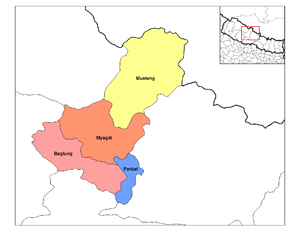
Upper Mustang
| Kingdom of Lo / Mustang སྨོནཋང |
||||
|---|---|---|---|---|
|
||||
 |
||||
| Capital | Lo Manthang | |||
| Official languages | ||||
| Establishment | 1380 | |||
| Area | ||||
| • | Total | 2,020[1] km2 700[1] sq mi |
||
| Population | ||||
| • | estimate | 7,000[1] | ||
| • | Density | 3.47/km2 10/sq mi |
||


Mustang (from the Tibetan möntang (Wylie: smon-thang ), Nepali: मुस्तांग "fertile plain"), formerly Kingdom of Lo, is a remote and isolated region of the Nepalese Himalayas. The Upper Mustang was a restricted demilitarized area until 1992 which makes it one of the most preserved regions in the world, with a majority of the population still speaking traditional Tibetic languages. Tibetan culture has been preserved by the relative isolation of the region from the outside world.
The Upper Mustang comprise the northern two-thirds of Mustang District of Dhawalagiri Zone, Nepal. The southern third of the district is called Thak and is the homeland of the Thakali, who speak the Thakali language, and whose culture combines Tibetan and Nepalese elements. Life in Mustang revolves around tourism, animal husbandry and trade.
Mustang's status as a kingdom ended in 2008 when its suzerain Kingdom of Nepal became a republic. The influence of the outside world, especially China, is growing and contributing to rapid change in the lives of Mustang's people.[2]
Climate
Upper Mustang has a transhimalayan climate which is cool and semi-arid with precipitation in the range of 250–400 mm. It is in the rain shadow of the Annapurna and Dhaulagiri ranges.
Demographics
The population of the whole Mustang District in 2001 was 14,981, spread between three towns and approximately thirty smaller settlements. The inhabitants are either Thakalis, Gurung or, in traditional Mustang, primarily Tibetan.
Most of the population of Mustang lives near the Kali Gandaki River, 2800–3900 m above sea level. The tough conditions cause a large winter migration into lower regions of Nepal. The administrative centre of Mustang District is at Jomsom (eight kilometers south of Kagbeni) which has had an airport since 1962 and has become the main tourist entry point since Mustang was opened to western tourism in 1992.
Geography

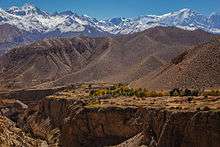

The main hydrographic feature of Mustang is the Kali Gandaki River. The river runs southward towards Nepal Terai, bisecting Mustang. Routes paralleling the river once served as a major trade route between Tibet and India, especially for salt. Part of the river valley in the southern Mustang District forms by some measures the deepest gorge in the world.
Traditional Mustang (the Lo Kingdom) is 53 km north–south at its longest, 60 km east–west at its widest and ranges from a low point of 2,750 m above sea level on the Kali Gandaki River just north of Kagbeni to 6,700 m at Khamjung Himal, a peak in southeast Mustang.
Transport
Upper Mustang is on an ancient trade route between Nepal and Tibet exploiting the lowest 4,660 metres (15,300 ft) pass Kora La through the Himalaya west of Sikkim. This route remained in use until China's annexation of Tibet in 1950.
Mechanized access inside Nepal began with the opening of an airstrip at Jomsom at the approximate boundary between the southern Thak and northern Lo sections of the valley, which was in operation by the 1960s.
China eventually decided to revitalize trade and in 2001 completed a 20 kilometres (12 mi) road from the international border to Lo Manthang.[3] Across the TAR border is Zhongba County of Shigatse Prefecture. China National Highway 219 follows the valley of the Yarlung Tsangpo River some 50 kilometres (31 mi) north of the border.
Meanwhile, road-building from the south was inhibited by difficulties along the Kali Gandaki Gorge to the south, but proceeded incrementally. In 2010, a 9 kilometres (6 mi) gap remained but the road was completed before 2015 and is suitable for high clearance and 4 WD vehicles. Currently, the easiest and only widely used road corridor, from Kathmandu to Lhasa—named Arniko Highway in Nepal and China National Highway 318 in the TAR—traverses a 5,125 metres (16,810 ft) pass. This is some 465 metres (1,530 ft) higher than Kora La.
History
Mustang was once an independent kingdom, although closely tied by language and culture to Tibet. From the 15th century to the 17th century, its strategic location granted Mustang control over the trade between the Himalayas and India. At the end of the 18th century the kingdom was annexed by Nepal.
Though still recognized by many Mustang residents, the monarchy ceased to exist on October 7, 2008, by order of the Government of Nepal.[4] The last official and current unofficial king (raja or gyelpo) is Jigme Dorje Palbar Bista (born c.1933), who traces his lineage directly back to Ame Pal, the warrior who founded this Buddhist kingdom in 1380.[5] Ame Pal oversaw the founding and building of much of the Lo and Mustang capital of Lo Manthang, a walled city surprisingly little changed in appearance from that time period.[6]
In 2007, a shepherd in Mustang discovered a collection of 55 cave paintings depicting the life of the Buddha.[7]
Tourism
.jpg)
Foreign visitors have been allowed to the region since 1992, but tourism to Upper Mustang is regulated. Foreigners need to obtain a special permit to enter, costing US$50 per day per person. Most tourists travel by foot over largely the same trade route used in the 15th century. Over a thousand western trekkers now visit each year, with over 2,000 in 2008. August and October are the peak visiting months. On August 27, 2010, local youth leaders in Mustang threatened to bar tourists beginning October 1, 2010 due to the refusal of the Nepalese government to provide any of the $50 per day fee to the local economy. Visitation, however, continued uninterrupted beyond that date.[8]
Mustang is rich in Buddhist culture, similar to the area of the Tibet Autonomous Region of the People's Republic of China. It is an alternate way to experience the Tibetan culture and landscape to the tours provided by the Chinese government. The Tiji festival in Lo-Manthang is another popular destination for tourists in the area seeking to experience the native culture.
The first westerner in Mustang was Toni Hagen, Swiss explorer and geologist, who visited the Kingdom in 1952 during one of his travels across the Himalayas. French Michel Peissel is considered the first westerner to stay in Lo Manthang, during the first authorised exploration of Mustang in 1964.[9]
In culture
- British Tibetologist David Snellgrove visited and researched Mustang's Buddhist temples and monasteries in 1956, 1960–61 and 1978.[10]
- In the book Merlins Keep, a novel by Madeleine Brent (alias of Peter O'Donnell) published 1977, Mustang is the setting for the heroine's youth and later adventures.
- Mustang is the setting for a large part of the book The Kingdom, a novel by Clive Cussler and Grant Blackwood published in 2011.
- In the 2013 movie Planes produced by DisneyToon Studios and released by Walt Disney Pictures one of the stops in Wings Across the World race is Nepal where the Planes land in Mustang.
See also
- Gandaki River
- Jomsom
- Jomsom Airport
- Kagbeni, Mustang
- Kali Gandaki Gorge
- Kali Gandaki River
- Lo Manthang
- Mustang District
- Tangbe
References
- 1 2 3 Raffaele, Paul (April 1998). "Into the Forbidden Kingdom of Mustang". Reader's Digest. 421. 71.
- ↑ Mustang: A Kingdom on the Edge Al Jazeera Correspondent
- ↑ "New highway divides isolated Buddhist kingdom of Mustang". Taipei Times. Taipei, Taiwan. AFP. May 19, 2007. Retrieved Dec 14, 2013.
- ↑ China View news
- ↑ Wild, windy and harsh, yet stunningly beautiful; The Sunday Tribune; April 21, 2002
- ↑ Peissel, Michel (1992) [1967]. Mustang - A Lost TIbetan Kingdom (2nd ed.). Book Faith India, Delhi. pp. 227–31.
- ↑ Shepherd leads experts to ancient Buddha cave paintings; Guardian Unlimited; May 4, 2007.
- ↑ Mustang to Bar Tourists
- ↑ Peissel, Michel [1967]. Mustang, a Lost Tibetan Kingdom, Books Faith, 2002
- ↑ Snellgrove, David (1989). Himalayan Pilgrimage, a Study of Tibetan Religion by a Traveller through Western Nepal (Second ed.). Boston & Shaftesbury: Shambhala.
Bibliography
- Marullo, Clara (1995). The Last Forbidden Kingdom, Mustang: land of Tibetan Buddhism. Photographs by Vanessa Schuurbeque. Charles E. Tuttle Co., Ltd., Rutland, Vermont. ISBN 0-8048-3061-4.
Documentaries
- Lost Treasures of Tibet, 2003-2-18.
- Steve Chao: Mustang: A Kingdom on the Edge. Al Jazeera Correspondent, 2012-2-20.
- The Last Lost Kingdom, a Feature Documentary by Larry Levene, 2014-2-20; www.facebook.com/mustang.elreino ; WEB:www.thelastlostkingdom.com;
External links
![]() Media related to Mustang (kingdom) at Wikimedia Commons
Media related to Mustang (kingdom) at Wikimedia Commons
Coordinates: 29°05′N 83°55′E / 29.083°N 83.917°E