Mussoorie
| Mussoorie मसूरी | |
|---|---|
| Hill station | |
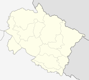 Mussoorie Location in Uttarakhand, India | |
| Coordinates: 30°27′N 78°05′E / 30.45°N 78.08°ECoordinates: 30°27′N 78°05′E / 30.45°N 78.08°E | |
| Country |
|
| State | Uttarakhand |
| District | Dehradun |
| Elevation | 2,005.5 m (6,579.7 ft) |
| Population (2001) | |
| • Total | 26,069 |
| Languages | |
| • Official | Hindi, Urdu |
| • Other | Garhwali , Hindi, English |
| Time zone | IST (UTC+5:30) |
| PIN | 248179 |
| Vehicle registration | UK 07, UK 09 |
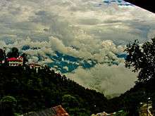
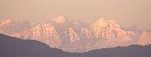
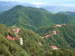
Mussoorie (Garhwali/Hindi: Masūrī) is a hill station and a municipal board in the Dehradun District of the northern Indian state of Uttarakhand. It is located about 35 km from the state capital of Dehradun and 290 km north from the national capital of New Delhi. This hill station is situated in the foothills of the Garhwal Himalayan range. The adjoining town of Landour, which includes a military cantonment, is considered part of 'greater Mussoorie', as are the townships of Barlowganj and Jharipani. The pin code for Mussoorie is 248179. [1] Being at an average altitude of 1,880 metres (6,170 ft), Mussoorie, with its green hills and varied flora and fauna, is a fascinating hill resort. Commanding snow ranges to the north-east, and glittering views of the Doon Valley and Shiwalik ranges in the south, the town was once said to present a 'fairyland' atmosphere to tourists.The second highest point is the original Lal Tibba in Landour, with a height of over 2,275 metres (7,464 ft).
History
Mussoorie was founded by Lt. Frederick Young ( Born 30 November 1786 at Green Castle, Moville, Ireland, Died 24 May 1874 in Ireland) of East India Company. Lt. Young came to these hills for the sole purpose of bagging some game.
He was so enamoured by the beauty that he decided to build a hunting lodge (shooting box) on the Camel's Back Road along with FJ Shore, Jt. Magistrate of Doon in 1823. He also raised the first Gurkha Regiment and planted the first potatoes in the valley. His tenure in Mussoorie ended in 1844 and he further served in Dimapore and Darjeeling and retired as a General and went back to Ireland.Sadly there are no memorials to commemorate Gen. Young in Mussoorie. However, there is a Young Road in Dehradoon on which ONGC's Tel Bhawan stands.
In 1832 Mussoorie was the intended terminus of the Great Trigonometric Survey of India that began at the southern tip of India. Although unsuccessful, the Surveyor General of India at the time, George Everest wanted to have the new office of the Survey of India based in Mussoorie. A compromise was to have it in Dehradun, where it still is.
In 1850 the first beer brewery in India was built in Mussoorie.[2] By 1894 there were 22 breweries in India producing 6 million gallons a year.
By 1901 Mussoorie's population had grown to 6,461, rising to 15,000 in the summer season. Earlier, Mussoorie was approachable by road from Saharanpur, 58 miles (93 km) away. Accessibility became easier in 1900 with the railway coming to Dehradun, thus shortening the road trip to 21 miles (34 km).[3]

The name Mussoorie is often attributed to a derivation of 'mansoor', a shrub which is indigenous to the area. The town is often referred to as 'Mansoori' by most Indians.
The main promenade in Mussoorie is called, as in other hill stations, the Mall. In Mussoorie, the Mall stretches from Picture Palace at its eastern end to the Public Library (shortened to 'Library') at its western end. During the British Raj, signs on the Mall expressly stated: "Indians and Dogs Not Allowed". Racist signs of this type were commonplace in hill stations, which were founded 'by and for' the British. Motilal Nehru, the father of Jawaharlal Nehru, deliberately broke this rule every day whenever he was in Mussoorie and would pay the fine. The Nehru family, including Nehru's daughter Indira (later Indira Gandhi) were frequent visitors to Mussoorie in the 1920s, 1930s and 1940s, and stayed at the Savoy Hotel. They also spent much time in nearby Dehradun, where Nehru's sister Vijayalakshmi Pandit ultimately settled full-time.
During the 1959 Tibetan Rebellion, the Central Tibetan Administration of the 14th Dalai Lama was at first established in Mussoorie before being moved to its present location in Dharamsala, Himachal Pradesh. The first Tibetan school was established in Mussoorie in 1960. Tibetans settled mainly in Happy Valley in Mussoorie. Today, some 5,000 Tibetans live in Mussoorie.
Now, Mussoorie suffers from overdevelopment of hotels and tourist lodges, given its relative proximity to Delhi, Ambala and Chandigarh, and has serious problems of garbage collection, water scarcity and parking shortages, especially during the summer tourist season. Landour, Jharipani and Barlowganj have fewer such problems.
Geography and climate
Mussoorie has an average elevation of about 2005.5 metres (6580 ft). The highest point is Lal Tibba, at a height of about 7500 ft (although the name Lal Tibba is now also used to describe a lovely lookout point, a short distance from the actual peak).
| Climate data for Mussoorie | |||||||||||||
|---|---|---|---|---|---|---|---|---|---|---|---|---|---|
| Month | Jan | Feb | Mar | Apr | May | Jun | Jul | Aug | Sep | Oct | Nov | Dec | Year |
| Record high °C (°F) | 20 (68) |
23 (73) |
26 (79) |
29 (84) |
34 (93) |
31 (88) |
29 (84) |
25 (77) |
27 (81) |
25 (77) |
25 (77) |
23 (73) |
34 (93) |
| Average high °C (°F) | 10 (50) |
12 (54) |
16 (61) |
21 (70) |
24 (75) |
23 (73) |
20 (68) |
20 (68) |
19 (66) |
18 (64) |
15 (59) |
13 (55) |
27 (81) |
| Average low °C (°F) | 2 (36) |
3 (37) |
7 (45) |
5 (41) |
14 (57) |
16 (61) |
15 (59) |
15 (59) |
14 (57) |
11 (52) |
7 (45) |
4 (39) |
10 (50) |
| Record low °C (°F) | −5 (23) |
−6 (21) |
−2 (28) |
−1 (30) |
4 (39) |
4 (39) |
11 (52) |
7 (45) |
1 (34) |
2 (36) |
−2 (28) |
−3 (27) |
−6 (21) |
| Average precipitation mm (inches) | 51 (2.01) |
52 (2.05) |
57 (2.24) |
30 (1.18) |
58 (2.28) |
174 (6.85) |
662 (26.06) |
670 (26.38) |
277 (10.91) |
64 (2.52) |
14 (0.55) |
18 (0.71) |
2,127 (83.74) |
| Source: | |||||||||||||
Demographics
As of 2011 India census,[4] Mussoorie had a population of 30,118. Males constitute 55% of the population and females 45%. Mussoorie has an average literacy rate of 89%, higher than the national average of 75%: male literacy is 94%, and female literacy is 84%. In Mussoorie, 9% of the population is under 6 years of age. In Mussoorie Nagar Palika Parishad, Female Sex Ratio is of 812 against state average of 963. Moreover, Child Sex Ratio in Mussoorie is around 918 compared to Uttarakhand state average of 890.
Accessibility
Mussoorie is conveniently connected by road to Delhi and major cities. It is called the "Gateway" to Yamunotri and Gangotri Shrines of Northern India. The closest rail station is Dehradun. Taxis are easily available for Mussorie as are buses at regular intervals.
The best time to visit is from mid-March to mid-November though torrential rain can be an inhibiting factor in the monsoon months of July to September.
Tourism


Tourism is the most significant segment of Mussoorie's economy. It has a nature walk known as "Camel's Back Road". This road takes its name from a rocky outcrop in the shape of a camel's hump. Along the road, a cemetery is located about mid-way on the loop. There is also "Gun Hill" where a cannon was used to sound out midday for many years. Gun Hill is accessible by the cable car on the Mall road. The oldest Christian church in the Himalayas, St Mary's, is situated above Mall Road, and is currently undergoing restoration. Kempty Falls is a nice picnic spot. Company Garden is popular tourist destination. During season, the Company Garden has a vast collection of flowers and plants. Happy Valley has a small Tibetan temple. This was the first Tibetan temple built in India. The temple was constructed in 1960 by the Tibetan refugees. Lal Tibba is another tourist spot of Mussoorie. Picturesque Dhanaulti hill station is about 32 kilometres from Mussoorie. Mussoorie also had India's largest roller skating rink.
Nahata Estate Previously known as "Childer's Lodge" is a huge property of more than 300 acres, owned by the Harakh Chand Nahata family. It is the highest peak of Mussoorie near Lal Tibba, it is situated at 5 km from the Tourist Office and one can go on horse back or on foot. The view of snow-clad mountains is exhilarating.
GunHill Second highest point of Mussoorie, at an altitude of 2024m located at 30°29′43″N 78°04′28″E / 30.4953°N 78.0745°E
Kempty Falls The Kempty Falls are situated on the hilly tracks of Uttarakhand, India, 15 km from Mussoorie on the Chakrata Road. This place is located nearly 1364 meters above sea level at 78°-02’East longitude and 30° -29’North latitude.
Lake Mist About 5 km before Kempty Falls on the Mussoorie-Kempty road is a good picnic spot with accommodation and restaurant facilities; boating is also available. With the Kempty river flowing through it, Lake Mist has many small waterfalls made by the river.

Municipal Garden Is a picnic spot having a garden and an artificial mini lake with paddle boating facility. It is located at a distance of 4 km by rickshaw cycles, pony or by a car and 2 km via Waverly Convent School road on foot.
Mussoorie Lake A newly developed picnic spot build by City Board & Mussoorie Dehradun Development Authority, is situated at 6 km on Mussoorie-Dehradun road having a facility of pedaled boats. It offers a view of Doon Valley and nearby villages.

Bhatta Falls 7 km from Mussoorie on Mussoorie-Dehradun Road near Bhatta Village. Accessible by car or bus up to Bhatta from where the fall is 3 km by foot. A fall with different ponds for bathing and water amusements, an ideal place for a picnic.
Jharipani Fall Located at 8.5 km from Mussoorie on Mussoorie-Jharipani road. One can go by local bus or car up to Jharipani from where the fall is about 1.5 km on foot.
Mossy Fall The fall is surrounded by a dense forest and is 7 km from Mussoorie. One can go there via Barlowganj or Balahisar.
Sir George Everest's House Park Estate is where one can find the remains of the building and laboratory of Sir George Everest, the Surveyor-General of India from 1830 to 1843. It is after George Everest that the world's highest peak Mt. Everest is named.[5] It is 6 km from Gandhi Chowk / Library Bazaar and is accessible by vehicle, although the road is very rough beyond Haathi Paon. The place provides a view of Doon Valley on one side and a panoramic view of the Aglar River valley and the snow peaks of the Himalayan ranges on the other. It is a scenic walk from Library Bazaar, and a picnic spot.
Nag Devta Temple An ancient temple dedicated to Snake God Lord Shiva and is situated on Cart Mackenzie Road about 6 km from Mussoorie on the way to Dehradun. Vehicles can go right up to the temple. This place provides an enchanting view of Mussoorie and the Doon Valley.

Jwalaji Temple (Benog Hill) Situated at an altitude of 2240 m, this temple is 9 km west of Mussoorie. It is situated on the top of Benog Tibba (Hill) and contains an old idol of Goddess Durga. There is a view of the Aglar River valley. It cannot be accessed by vehicle although a motor road goes most of the way from Mussoorie.
Cloud End This hotel is surrounded by thick deodar forest. The bungalow, built in 1838 by a British major, was one of the first four buildings of Mussoorie and has now been converted into a hotel. The place provides peace and calm and is full of flora and fauna.
Van Chetna Kendra 11 km to the South of library point lies an old sanctuary established in 1993 and covering an area of 339 hectares. It is famous for the extinct bird species Mountain Quail (Pahari Bater), which was last spotted in 1876.
Mussoorie is a popular destination for honeymooning couples, mainly because of its relatively cool climes and calm and lovely environment.
Institutions
There is Christian Institution called the Landour Community Hospital. It is a small mission hospital run by the Emmanuel Hospital Association, Delhi catering to the medical needs of the people on the hills for the last 75 years.

The schools include Convent of Jesus and Mary, Waverly (1845), St. George's College (1853), Woodstock School (1854), Oak Grove School (1888), Wynberg-Allen (1888), Guru Nanak Fifth Centenary (1969), Convent of Jesus and Mary Hampton Court.

St. George's College, Mussoorie (founded in 1853) is amongst the oldest and most reputed schools in the country. It has been run by the Patrician Brothers since 1893. Spread over 400 acres (1.6 km2), the school is also popularly referred to as 'Manor House'. Over the years, its alumni have made distinguished contributions in several fields, especially in serving the armed forces of the nation. The school's imposing facade stands out as one of the main architectural attractions of Mussoorie.
Woodstock School is a Christian, international, co-educational, residential school located in Landour, a small hill station contiguous with the town of Mussoorie, Uttarakhand, India. The school traces its origin to the 1850s when a group of English ladies were enlisted by British officers and American missionaries to provide a Protestant education for girls.
Woodstock is among the most well-known boarding schools of the Indian Subcontinent, said by some to be currently the best international school in India. (Others are the Kodaikanal International School and the Hebron School, Ooty, both in South India). The school has a campus spread over an area of about 250 acres (1 km2), and is located in a forest region with a variety of flora including pine, rhododendron, and oak. The terrain of the campus has an altitudinal range of 350 meters from its lowest point to the highest point. Classes at Woodstock begin from ECP (Early Childhood Program) and follow up to grade 12.

Oak Grove School stands out from the other notable institutions of Mussoorie for two reasons. First, it is affiliated with the CBSE, New Delhi, which is a rarity amongst the residential schools of Mussoorie. Second, it is a secular government-aided school, run by the Northern Railway. The school was founded in 1888 by the East Indian Railway (EIR) and passed to the Indian Railways when railways were nationalised after Independence. It has three separate semi independent wings, and is situated on two hills in Jharipani, 8 km from Mussoorie town, near the famous Jharipani fall.

Wynberg Allen School, established in 1888, is a well-known school which ranks amongst the finest in the country. In Kanpur, during the year 1887, a group of friends, Mr. Alfred Powell, Mr. and Mrs. Arthur Foy and Brigadier J H Condon met and decided to set up a school in Mussoorie. The school was built at Jabarkhet along the Tehri road and was later shifted to the present Wynberg Estate. The object was to provide for and give to children, wholly or partly of European descent, an education based on Protestant Christian principles; to maintain such children and to give them an academic and practical training conducive to economic welfare and happiness. It now accommodates students of all descents.
The school consists of two branches – the Junior branch (Wynberg) and the Senior branch (Allen) and accommodates around 700 children. The school has four houses – Allen, Powell, Foy and Condon. A student from the institution is referred to as an " ALWYNIAN "

The Convent of Jesus and Mary, Waverley, Mussoorie was established in 1845 by the Religious Sisters of Jesus and Mary Mussoorie Educational Society. The school is conducted by the Religious Sisters of Jesus and Mary. It is an all-girls school and perhaps the oldest Convent school in India. Waverley is situated at an elevation of 7,000 feet above sea level on one of the healthiest, most extensive and well wooded hills of Mussoorie. The Jesus and Mary Congregation was the first Congregation of Sisters to come to the north in 1842 at the invitation of Bishop Borghi the Vicar Apostolic of the Agra Mission. The Archbishop requested the sisters to come to Mussoorie to start a school for girls. In 1845 the sisters came to Mussoorie. The Estate of Waverley belonging to an Italian gentleman had just come into the market and the nuns bought it. That year saw the commencement of one of the most important Catholic educational institutions in the North of India. Thousands of girls Catholic and Non-Catholic alike have since passed through Waverley the small inadequate bungalow which was all the accommodation at first offered, has given place to a group of tastefully conceived buildings which dominate the town of Mussoorie.


The Guru Nanak Fifth Centenary School Mussoorie (GNFCS), is another one of Mussoorie's well-known schools and one of the best boarding establishments in India. Previously owned by the Seventh-day Adventists and known from 1922–1969 as Vincent Hill School, GNFCS purchased the land and extensive buildings and founded an international school in the sacred memory of Sri Guru Nanak Dev Ji, on the occasion of His 500th birth anniversary, celebrated in November 1969. The girls are housed at Shangri La situated at 6,750 feet (2,057 m) above sea level on an 11-acre (45,000 m2) plot, wooded with cypress, cedar and oak, on the south and west, facing the snow clad Himalayan peaks, to the north. The boys are at Vincent Hill, it is situated 3 km from the Library Chowk. Surrounded by picturesque scenery, and upgrading the old Vincent Hill School, it comprises a campus spread over 45 acres (180,000 m2). The GNFCS prepares students in accordance with the 10+2 formula for school education, for the Indian Certificate of Secondary Education (10 year course) examination and the Indian School Certificate (12 year course) examination.
Other schools in Mussourie include Mussoorie International School (founded in 1984), Mussoorie Modern School,[6] Tibetan Homes, CST Mussoorie and St Clares Convent School.

Mussorie also has the Lal Bahadur Shastri National Academy of Administration,[7] the premier training institute for officers of the Indian Foreign Service,Indian Administrative Service and other civil services. This unique institute is located about 2 km from Gandhi Chowk.
The library area also houses the premier academy of the Indo-Tibetan Border Police Force, an elite central Police organization belonging to the Government of India. It is a well respected institute for training ITBP officer recruits patrolling the porous borders. The Academy was moved to this location in 1978, consequent upon reorganization of the force, and located at two separate patches of land known as Cainville Estate (Adminb wing) and Astel estate (Combat wing) The Academy has grown over the years so as to take even friendly foreign countries officers as its trainees. State of the art facilities have been established here in order to provide the latest modern training to its trainees. The Academy has a helipad, synthetic tennis courts, modern computer labs and simulators besides one of the best libraries in town.
The Academy also serves the local inhabitants as the first-responder in any major or minor rescue and relief work, be it a traffic accident, or a cable car mishap, ITBP has provided much needed relief immediately. They have also been instrumental in assisting the town's local administration in preserving the green cover of this exotic hill station. The Academy is headed by Sh M.C. Bhatt, IG, at present, with Sh Satyendra Kumar as Commandant.
References
- ↑ "Mussoorie Pin code". citypincode.in. Retrieved 2015-03-03.
- ↑ 'Documentary History of the U.S. Brewers' Association, Part 1' by the United States Brewers' Association, page 63
- ↑ Mussoorie
 This article incorporates text from a publication now in the public domain: Chisholm, Hugh, ed. (1911). "article name needed". Encyclopædia Britannica (11th ed.). Cambridge University Press.
 - ↑ "Mussoorie Population Census 2011". Census Commission of India. Archived from the original on 2011-03-27. Retrieved 2016-09-19.
- ↑ Mussoorie, Places of Interest Official website of Dehradun city
- ↑ "Mussoorie Modern School (MMS)". mussooriemodernschool.com.
- ↑ "LBSNAA". civilservices.gov.in.
External links
| Wikimedia Commons has media related to Mussoorie. |
- Mussoorie on official website of Dehradun district
- Resorts near Delhi for Weekend
 Mussoorie travel guide from Wikivoyage
- Photographs of Sir George Everest's, house and laboratory, in Mussoorie, India
- Letitia Elizabeth Landon's poem 'The Abbey near Mussooree. The seat of J. C. Glen, Esq.', with illustration