District Municipality of Muskoka
| District of Muskoka | |
|---|---|
| Regional municipality (upper-tier) | |
| District Municipality of Muskoka | |
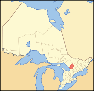 Map showing Muskoka District Municipality location in Ontario | |
| Coordinates: 45°10′N 79°20′W / 45.167°N 79.333°WCoordinates: 45°10′N 79°20′W / 45.167°N 79.333°W | |
| Country |
|
| Province |
|
| Government | |
| • Chair Governing Body | John Klinck |
| Area[1] | |
| • Land | 3,937.76 km2 (1,520.38 sq mi) |
| Population (2011)[1] | |
| • Total | 58,047 |
| • Density | 14.7/km2 (38/sq mi) |
| Time zone | Eastern (EST) (UTC-5) |
| • Summer (DST) | Eastern (EDT) (UTC-4) |
| Website | www.muskoka.on.ca |
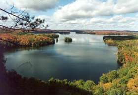
The District Municipality of Muskoka, more generally referred to as the District of Muskoka or Muskoka, is a Regional Municipality located in Central Ontario, Canada. Muskoka extends from Georgian Bay in the west, to the northern tip of Lake Couchiching in the south, to the western border of Algonquin Provincial Park in the east. Located approximately a two-hour car drive north of Toronto, Muskoka spans 6,475 km2 (2,500 sq mi). Muskoka has some 1,600 lakes, making it a popular cottaging destination.
This region, which, along with Haliburton, Kawartha Lakes, and Peterborough County is referred to as "cottage country", sees over 2.1 million visitors annually. Muskoka is a scenic area sprinkled with picturesque villages and towns, farming communities, and lakeside vacation hotels and resorts near to golf courses, country clubs, and marinas. The regional government seat is Bracebridge and the largest population centre is Huntsville.
The name of the municipality derives from a First Nations chief of the 1850s. Lake Muskoka was then the hunting grounds of a band led by Chief Yellowhead or Mesqua Ukie. He was revered by the government, who built a home for him in Orillia where he lived until his death at the age of 95.
Muskoka has 60,000 permanent residents, but an additional 100,000 seasonal property owners spend their summers in the region every year, making this a major summer colony. Many of the seasonal properties are large mansion-like summer estates, some of which have been passed down through families from generation to generation. Most of these expensive properties can be found along the shores of Muskoka's three major lakes: Lake Muskoka, Lake Rosseau, and Lake Joseph. In recent years, various Hollywood and sports stars have built retreats in Muskoka, including Steven Spielberg, Tom Hanks, Mike Weir,[2] Martin Short, Harry Hamlin, Cindy Crawford, Goldie Hawn and Kurt Russell.
The Muskoka region was ranked #1 for best trips of 2011 by National Geographic. Also was among the best trips of 2012 by National Geographic.
The soap opera Paradise Falls, about a fictitious cottage community, was shot partly on location here, to take advantage of the scenic background. Many summer camps are located in the region, to take advantage of the lakes, which offer opportunities for canoeing, sailing, windsurfing, kayaking, waterskiing, and other water activities. The area provides a refuge from hot cities during the summer months.
There are six municipalities in Muskoka: the towns of Bracebridge, Gravenhurst, and Huntsville; and the townships of Georgian Bay, Lake of Bays, and Muskoka Lakes. The Wahta Mohawk Territory and Moose Point 79 are also in the district.
The animated TV show Total Drama Island was said to take place in an unspecified area in Muskoka, which aired on Teletoon.
History
Native peoples
Geography drove history in the Muskoka region. Studded with lakes and rocks, the good land offered an abundance of fishing, hunting, and trapping, but was poorly suited to farming. Largely the land of the Ojibwa people, European inhabitants ignored it while settling what they thought were the more promising area south of the Severn River. The Ojibwa leader associated with the area was Mesqua Ukie, for whom the land is believed named, as he was liked by the European Canadians. The tribe lived south of the region, near present-day Orillia. They used Muskoka as their hunting grounds. Another Ojibwa tribe lived in the area of Port Carling, then called Obajewanung. The tribe moved to Parry Sound around 1866.
Since the late nineteenth century, Doncaster Reserve 14 is an area used for hunting and fishing by Mohawk from both the independent Kanesatake and Kahnewake reserves. An area was bought by the Sulpician Order brothers based in Oka, Quebec, to relocate Mohawk from that area because of a continuing dispute over land rights. In the early 21st century, this reserve has fewer than 10 residents.[3]
European arrival
Until the late 1760s, the European presence in the region was largely limited to seasonal fur trappers, but no significant trading settlements were established. Canadian government interest increased following the American Revolution when, fearing invasion from its new neighbour to the south, the government began exploring the region. It hoped to develop a settled population there and wanted to find travel lanes between Lake Ontario and Georgian Bay.[4] In 1826, Lieutenant Henry Briscoe became the first European man known to have crossed the middle of Muskoka. The explorer David Thompson drew the first maps of the area in 1837 and possibly camped near present-day Beaumaris.
Canada experienced heavy immigration from Europe in the 19th century, and Muskoka was no different. Large numbers of settlers from the United Kingdom, and to a lesser extent, Germany began to arrive. As the land south of the Severn was settled, the government planned to open the Muskoka region further north to settlement. Logging licences were issued in 1866 which opened Monck Township to logging.
The lumber industry expanded rapidly, denuding huge tracts of the area. They developed road and water transportation which contributed to later town settlement. The railroad pushed north to support the industry, reaching Gravenhurst in 1875 and Bracebridge in 1885. Road transportation took the form of the Muskoka Colonization Road, begun in 1858 and reaching Bracebridge in 1861. The road was roughly hewn from the woods and was of corduroy construction. Logs were placed perpendicular to the route of travel to keep carriages from sinking in the mud and swamps. This made for extremely rugged travel. The lumbering industry spawned a number of ancillary developments, with settlements springing up to supply the workers. Bracebridge (formerly North Falls) saw some leather-tanning businesses develop. Tanners used the bark from lumber to tan hides, turning what would otherwise be a waste product to effective use.
The passages of the Free Grants and Homestead Act of 1868 opened the era of widespread settlement to Muskoka. Settlers could receive free land if they agreed to clear the land, have at least 15 acres (61,000 m2) under cultivation, and build a 16 by 20-foot (6.1 m) house. Settlers under the Homestead Act, however, found the going hard. Clearing 15 acres (61,000 m2) of dense forest is a huge task. Once the land was clear, the settlers had to attack Muskoka's ubiquitous rocks, which also had to be cleared. Consisting largely of a dense clay, the soil in the region turned out to be poorly suited to farming.
As news of the difficult conditions spread back to the south, development in Muskoka began to falter, but development of the steamship revived industry. In a time when the railroads had not yet arrived and road travel was notoriously unreliable and uncomfortable, the transportation king was the steamship. Once a land connection was made to the southern part of the lake in Gravenhurst, the logging companies could harvest trees along the entire lakefront with relative ease. Steamships gave them the way to ship the harvest back to the sawmills in Gravenhurst.
The steamship era
Alexander Cockburn answered the call. Sometimes called the Father of Muskoka,[5] Cockburn began placing steamers on the lake. Starting with his steamship the Wenonah, Ojibwa for "first daughter", in 1866 Cockburn pressed the government to open the entire Muskoka lake system to navigation. He urged installing locks in Port Carling and opening a cut between Lake Rosseau and Lake Joseph at Port Sanfield. The government was eager to reinforce development in light of the faltering agricultural plan, and built the big locks in Port Carling in 1871. Cockburn's steamers had access to the entire lake system. Through the years he added more ships; when he died in 1905, his Muskoka Navigation Company was the largest of its kind in Canada.[5]
Shortly after the arrival of the steamships, another industry began to develop as agriculture never could. 1860 two young men, John Campbell and James Bain Jr, made a journey that marked them as perhaps the first tourists in the region.[6] Taking the Northern Railway to Lake Simcoe, they took the steamer Emily May up the lake to Orillia, and rowed across Lake Couchiching. They walked up the Colonization Road to Gravenhurst, where they vacationed. They liked what they saw and repeated the journey every year, bringing friends and relatives. These early tourist pioneers increased demand for transport services in the region. People were drawn by excellent fishing, natural beauty, and an air completely free of ragweed, providing relief for hay fever sufferers.
Early tourists built camps, but were joined by others desiring better accommodations. Farmers who were barely scratching a living from the rocky soil soon found demand for overnight accommodations literally arriving on their doorsteps. Some made the switch quickly and converted to boarding houses and hotels. The first wilderness hotel, called Rosseau House, was built at the head of Lake Rosseau in 1870. It was owned by New Yorker W. H. Pratt. The idea caught on and the number of tourists increased, establishing the tourist industry as the up-and-coming money earner in the 1880s.
The steamship era gave rise to the area's great hotels: Rosseau, Royal Muskoka, Windermere, and Beaumaris. When the railroad reached Gravenhurst in 1875, the area grew rapidly. Travel from Toronto, Pittsburgh, and New York City became less a matter of endurance than expenditure. Trains regularly made the run from Toronto to Gravenhurst, where travellers and their luggage were transferred to the great steamers of the Muskoka Navigation Co, such as the Sagamo. Making regular stops up the lakes, including at Bracebridge, Beaumaris, and Port Carling, tourists could transfer to smaller ships, such as the Islander. These could reach smaller ports. Improving transportation links opened smaller or more remote upper Muskoka lakes (Fairy, Vernon, Mary, Peninsula and Lake of Bays) to tourism around the turn of the 20th century, with steamers out of Huntsville servicing hotels like Deerhurst on Peninsula Lake. The Portage Railway between Peninsula Lake and Lake of Bays enabled comparatively easy access to the latter, resulting in a blossoming of tourism there, with 21 hotels eventually springing up,[7] among them notably the Wawa and Britannia[8] hotels and perhaps culminating in the Bigwin Inn.
The hotels became the centres of wealthy vacationers' lives, and families conducted extended stays that could stretch for weeks or months in the summer. As families became seasonally established, they began building cottages near the hotels; at first simple affairs replicating the rustic environment of the early camps. Later they built grander homes, including in some cases, housing for significant domestic staff. Initially cottagers relied on rowboats and canoes for daily transport and would sometimes row substantial distances. In the era of the steam and gasoline launch, tourists relied less on muscle power and more on motors. With the boats, the wealthier summer people built boathouses, often elaborate structures in their own right, in many cases designed with the look and feel of the main "cottage".
The coming of the car
World War I caused a significant dip in the tourist activity for the area and hence the economy. After the war, however, significant advances in the automobile brought demand for improved (paved) roads. These two developments, motorboats and private cars, brought greater overall development of the area; they also stimulated the spread of development around the lakes, as people no longer needed to be near major landings. Freed from the ports of call of the steamships, people built cottages farther afield. Demand began dropping for passenger billets on the steamship lines.
Meanwhile, demand increased for air transportation. The earliest runways of Muskoka Airport were laid out in 1933.[9] The airport has been intermittently upgraded. It was used strategically during World War II as a training field for the Norwegian Air Force after the Nazi occupation of Norway.
The demands of World War II slowed residential development in this area. Wartime shortages kept many Americans at home and many Canadians were engaged in war activities. Postwar prosperity brought another boom based around the availability of the automobile, improved roads, and the newly affordable fiberglass boat. Suddenly owning a summer cottage became possible not only for the adventurous or the wealthy, but for many in the middle class. They traveled by private automobiles, and the steamship companies were forced to retire their ships one by one, until the last sailing in the late 1950s.
Subdivisions
Municipalities:
- Town of Bracebridge
- Town of Gravenhurst
- Town of Huntsville
- Township of Georgian Bay
- Township of Lake of Bays
- Township of Muskoka Lakes
Native reserves:
Demographics
| Canada census – District Municipality of Muskoka community profile | |||
|---|---|---|---|
| 2011 | 2006 | 2001 | |
| Population: | 58,047 (0.8% from 2006) | 57,563 (8.4% from 2001) | 53,106 (5.2% from 1996) |
| Land area: | 3,937.76 km2 (1,520.38 sq mi) | 3,890.24 km2 (1,502.03 sq mi) | 3,890.42 km2 (1,502.10 sq mi) |
| Population density: | 14.7/km2 (38/sq mi) | 14.8/km2 (38/sq mi) | 13.7/km2 (35/sq mi) |
| Median age: | 45.3 (M: 44.4, F: 46.3) | 42.2 (M: 41.3, F: 43.0) | |
| Total private dwellings: | 44,619 | 44,634 | 42,843 |
| Median household income: | $61,159 | $43,661 | |
| Notes: Excludes census data for incompletely enumerated Indian reserves. – References: 2011[1] 2006[10] 2001[11] | |||
Senior administrators
- John Klinck, Chair and CEO
- Michael Duben, Chief Administrative Officer
- Jamie Clow, Commissioner of Legal Services and Regional Solicitor
- Fred Jahn, Commissioner of Public Works
Historic townships
Baxter township named for the Honourable Jacob Baxter, MPP for Haldimand County, Ontario from 1887 to 1898 and was Speaker of the Ontario Legislature from 1887 to 1891.
Brunel Township named for noted civil engineer Isambard Kingdom Brunel, Engineer-in-Chief to the Great Western Railway of England. Known in Canada for constructing the steamship Great Western.
Cardwell township named for Viscount Cardwell, Secretary of State for the Colonies from 1864 to 1866.
Chaffey Township named for a relative of Hon. Stephen Richards, Benjamin Chaffey, a Brockville contractor who helped build the St. Lawrence canals. Chaffey's sister was the wife of Hon. Stephen Richards.
Draper Township named for judge Hon. William Henry Draper, Solicitor General of Upper Canada in 1837 and Attorney General of Upper Canada in 1840.
Franklin township named for Arctic explorer Admiral Sir John Franklin.
Freeman township named for John Bailey Freeman, MPP for the North riding of Norfolk County from 1879 to 1890.
Gibson township named for Thomas Gibson MPP for a Huron riding from 1867 to 1898.
Macaulay township named for Chief Justice of the Common Pleas Sir James Buchanan Macaulay (1793–1859), veteran of the War of 1812.
McLean township named for Archibald McLean (1791–1865) a veteran of the War of 1812 he became Chief Justice of Upper Canada.
Medora township named for Mrs. Medora Cameron wife of a Toronto lawyer. She was also a niece of Hon. Stephen Richards, Commissioner of Crown Lands, hence the honour she received.
Monck township named for Viscount Monck, Lord of the Treasury in the Palmerston government in the United Kingdom from 1855 to 1857 and governor-general of British North America from 1861 to 1868.
Morrison township named for Mr. Angus Morrison who represented the North riding of Simcoe County from 1854 to 1863. Morrison was also a director of the old Northern Railway of Canada, Muskoka's pioneer railway, the terminus of which was Gravenhurst. Morrison was also Mayor of Toronto from 1876 to 1878.
Muskoka township and district and lake are named for one of the principal Chief of the Chippawa Nation. In 1815 he signed the treaty which the Indian title to a vast territory was surrendered to the Crown. The name means "Red Ground".
Oakley township named for one (which one is uncertain) of 13 villages of the name in Great Britain, 12 of which are in England, one in Scotland.
Ridout township named for the Ridout family, a very prominent Toronto family. They came from Sherborne in Dorsetshire, England, hence the name of Sherborne township, Haliburton County, which adjoined Ridout township on the East and hence also Dorset, a village in the township. Thomas Ridout was Surveyor-General of Upper Canada.
Ryde township named for the town of Ryde on the Isle of Wight.
Sinclair township, named for Donald Sinclair MPP for the North Riding of Bruce County from 1867 to 1883.
Stephenson township named for Robert Stephenson, son of George Stephenson of locomotive fame, Robert Stephenson designed the Victoria Tubular Bridge at Montreal, then the greatest Canadian bridge.
Stisted township named for Major General Henry William Stisted, Lieutenant-Governor Ontario from Confederation, July 1, 1867 to 1868.
Watt Township named for James Watt of steam engine fame.
Wood township named for Hon. Edmund Burke Wood, Provincial Treasure in the John Sandfield Macdonald Government. In 1874, appointed Chief Justice of Manitoba.
See also
References
Bracebridge Gazette, November 11, 1937, an address by Redmond Thomas, Assistant Editor of the Bracebridge Gazette, delivered to a meeting of the Men Teachers' Federation of Muskoka.
Ahlbrandt, Patricia (1989). Beaumaris. Erin, Ontario: Boston Mill Press.
- 1 2 3 "Muskoka, District municipality, census profile". 2011 Census of Population. Statistics Canada. Retrieved 2012-03-19.
- ↑ "Mike Weir makes Taboo his home course". MikeWeir.com. Retrieved January 31, 2007.
- ↑ Smith, Donald B. (1982). "Onasakenrat Joseph". In Halpenny, Francess G. Dictionary of Canadian Biography. XI (1881–1890) (online ed.). University of Toronto Press., accessed 13 October 2015
- ↑ Ahlbrandt p 16
- 1 2 Ahlbrandt p 21
- ↑ Ahlbrandt p35
- ↑ Barbaranne, Boyer (August 1, 1996). Muskoka's Grand Hotels. Boston Mills Press. ISBN 978-1550460513.
- ↑ "Britannia, Lake of Bays, Muskoka, a summer hotel, 1910". archive.org. 1910. Retrieved 21 February 2016.
- ↑
- ↑ "2006 Community Profiles". Canada 2006 Census. Statistics Canada. March 30, 2011. Retrieved 2012-03-19.
- ↑ "2001 Community Profiles". Canada 2001 Census. Statistics Canada. February 17, 2012. Retrieved 2012-03-19.
12. ^ http://www.mymuskokanow.com/30091/bracebridge-residents-form-website-in-opposition-to-proposed-sewage-project/ Residents on McCrank and Westvale Drive in Bracebridge are taking a proactive approach in opposing a proposed sewage line.
On Thursday a new website named ‘Oppose Bracebridge Sewers’ went live.
External links
| Wikivoyage has a travel guide for Muskoka. |
| Wikimedia Commons has media related to Muskoka District Municipality, Ontario. |
- District of Muskoka
- Muskoka District 1886-87 Map
- Muskoka Tourism
- Doitinmuskoka Area Guide
- Muskoka Magazine
- Ontario Tourism Investment Communique Muskoka
- Muskoka and Haliburton, 1615-1875: A Collection of Documents. Toronto: Champlain Society Publications, 1963.
- Guide book & atlas of Muskoka and Parry Sound Districts. Toronto: H.R. Page. 1879. p. 156. Retrieved 29 April 2016.
 |
Parry Sound District | Nipissing District | | |
| Georgian Bay | |
Haliburton County | ||
| ||||
| | ||||
| Simcoe County, Kawartha Lakes (single-tier city) |
| Regions | |
|---|---|
| Counties | |
| Districts | |
| Regional municipalities | |
| Single-tier municipalities | |
| Separated municipalities | |
| |