Musconetcong River
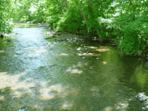
The Musconetcong River is a 45.7-mile-long (73.5 km)[1] tributary of the Delaware River in northwestern New Jersey in the United States. It flows through the rural mountainous country of northwestern New Jersey. Part of it is a National Wild and Scenic River.[2]
It rises out of Lake Hopatcong, on the border between Sussex and Morris counties. It flows through Lake Musconetcong, then flows southwest, past Stephensburg and New Hampton, passing south of Washington then along the southeastern side of the Pohatcong Mountain ridge. It joins the Delaware across from Riegelsville, Pennsylvania, approximately 10 mi (16 km) south of Phillipsburg.
The river does not flow through any large population center and has been the site of relatively little industrial development throughout its history. In the 18th century, the surrounding hills were largely deforested as a source of charcoal for the iron industry in the surrounding region. The local industry declined by the middle of the 19th century after the building of the former Morris Canal, the course of which ran along the upper river, to bring coal from Pennsylvania to northern New Jersey. After the demise of the canal from the introduction of railroads in the late 19th century, the dam pools along the river that supplied the canal became the site of a popular summer cottage industry. Silted remnants of the pools, as well as the remnants of the canal itself, can still be seen along the river.
Human habitation in the Musconetcong Valley can be traced back approximately 12,000 years to the end of the last ice age. The Plenge Site along the lower river in Warren County was the first of only two major Paleo-Indian archaeological site excavations in New Jersey, and is considered one of the most significant in the northeastern United States.
The USGS stream flow gauge at Bloomsbury has the river's flows recorded from as far back as 1904. The average flow over the time recorded for the gauge at Bloomsbury is approximately 244 cfs. Record flows of the river were recorded in 2011 as result of Hurricane Irene.[3]
According to an urban legend, the river is also home to a creature known as the Musconetcong River Mantis Man, a somewhat humanoid, somewhat insect-like creature.[4]
See also
References
- ↑ U.S. Geological Survey. National Hydrography Dataset high-resolution flowline data. The National Map, accessed April 1, 2011
- ↑ "Musconetcong Wild and Scenic River, New Jersey". The Wild & Scenic Rivers Council. Retrieved 22 October 2011.
- ↑ "Hurricane Irene causes record flows in Musconetcong River at Bloomsbury". NJ.com. Retrieved 2013-09-21.
- ↑ Urban legend: Have you seen the Musconetcong Mantis Man?
External links
- Musconetcong Watershed Association
- New Jersey Skylands: Musconetcong River
- U.S. Geological Survey: NJ stream gaging stations
- Musconetcong River Watershed -- photographs & discussion group on flickr
- NY-NJTC: Musconetcong River Reservation Details and Info
Coordinates: 40°38′09″N 75°07′21″W / 40.635848°N 75.122478°W