Murshidabad district
| Murshidabad মুর্শিদাবাদ | |
|---|---|
 | |
| Country |
|
| State | West Bengal |
| Government | |
| • Lok Sabha constituencies | Jangipur, Baharampur, Murshidabad |
| • Vidhan Sabha constituencies | Farakka, Samserganj, Suti, Jangipur, Raghunathganj, Sagardighi, Lalgola, Bhagabangola, Raninagar, Murshidabad, Nabagram, Khargram, Burwan, Kandi, Bharatpur, Rejinagar, Beldanga, Baharampur, Hariharpara, Naoda, Domkal, Jalangi |
| • Administrative Division | Presidency |
| • Headquarters | Baharampur |
| Area | |
| • City | 5,324 km2 (2,056 sq mi) |
| Population (2011)[1] | |
| • City | 7,103,807 |
| • Density | 1,334/km2 (3,460/sq mi) |
| • Urban | 1,400,692 |
| • Rural | 5,703,115 |
| Demographics | |
| • Population Growth | 21.09% |
| • Literacy | 66.59% |
| • Sex Ratio | 958 |
| Languages | |
| • Official | Bengali, English |
| Time zone | IST (UTC+5:30) |
| Website | Official Website |
Murshidabad district (Bengali: মুর্শিদাবাদ জেলা) is a district of West Bengal, in eastern India. Situated on the left bank of the river Ganges, the district is very fertile. Covering an area of 5,341 km² (2,062 sq mi) and having a population 5.863m (according to 2001 census), it is a densely populated district[2] and the ninth most populous in India (out of 640).[3] Baharampur town is the headquarters of the district.
The Murshidabad city, which lends its name to the district, was the seat of power of the Nawabs of Bangla. All of Bengal was once governed from this town. A few years after Nawab Siraj-ud-Daula lost to the British at the Battle of Plassey, the capital of Bengal was moved to the newly founded city of Calcutta.[4]
It borders West Bengal's Malda district to the north, Jharkhand's Sahebganj district and Pakur district to the north-west, Birbhum to the west, Bardhaman to the south-west and Nadia district due south. The international border with Bangladesh Rajshahi Division is on the east.
Etymology
- See also: 18th-century history of Murshidabad
The district is named after the historical town of Murshidabad, which was named after Murshidabad.
History
Prehistory
The capital city of Shashanka, the great king of Gda (comprising most of Bengal) in the seventh century AD and perhaps that of Mahipala, one of the later Pala kings of Bengal, were in this district. The earliest evidences of the history of the district date back to the pre-historic days, perhaps as early as circa 1500 BCE.[5]
18th century
The district got its present name in the early eighteenth century and its present shape in the later half of the eighteenth century. Murshidabad town, which lends its name to the district, derived its name from its founder, Murshid Quli Khan. Travellers marvelled at its glory through the ages. The city, lying just east of the Bhagirathi River, is an agricultural trade and silk-weaving centre. Originally called Makhsudabad, it was reputedly founded by the Mughal emperor Akbar in the 16th century.[6] Kartalab Khan was appointed as Diwan of Bengal Subah in 1701 CE by Aurangzeb. He shifted his office from Dacca (present day Dhaka) to Maksudabad in 1702 CE. In 1703 CE, Aurangzeb honoured him with the title of Murshid Quli Khan and granted the permission to rename the town as Murshidabad in 1704 CE after his newly acquired title.[7]
In 1704 the nawab Murshid Quli Khan changed the seat of government from Dacca to Maksudabad, which he called after his own name. The Nawab Murshid Quli Khan made Murshidabad the capital city of Sube Bangla, comprising Bengal, Bihar, and Orissa. The family of Jagat Seth maintained their position as state bankers at Murshidabad from generation to generation. The East India Company reigned from here for many years after the Battle of Plassey.
Warren Hastings removed the supreme civil and criminal courts to Calcutta in 1772, but in 1775 the latter court was brought back to Murshidabad again. In 1790, under Lord Cornwallis, the entire revenue and judicial staffs were fixed at Calcutta. The town is still the residence of the nawab, who ranks as the first nobleman of the province with the style of Nawab Bbahadur of Murshidabad, instead of Nawab Nazim of Bengal. The Murshidabad palace, dating from 1837, is a magnificent building in Italian style. The city still bears memories of Nawabs with other palaces, mosques, tombs, and gardens, and retains such industries as carving in ivory, gold and silver embroidery, and silk-weaving.[5]
Modern era
The first wave of movements for freedom from the rule of company was led by the Ulema until the middle and late 19th century. In the 19th century the nature of the struggle changed, and all communities joined forces for Independence from British rule.
Like other areas of Bengal Murshidabad also made its contribution to the freedom struggle of India. The Murshidabad District Committee of the Indian National Congress was formed in 1921. Brajabhushan Gupta was its first President. The students participated in movements like the Boycott of Foreign Goods and had links with the revolutionaries. In the Krishnanath College of Berhampore revolutionaries like Surya Sen and Niranjan Sen spent their college days. Netaji Subhas Chandra Bose and Kazi Nazrul Islam spent some of their prison days. Mahatma Gandhi, Dr. Rajendraprasad, C. R. Das and Netaji had also visited the district of Murshidabad during the freedom struggle days.
The efforts of Nawab Wasif Ali Mirza in forming the Hindu Muslim Unity Association in 1937 were also noteworthy. In 1943 a conference of the Association in Kolkata was arranged, at the request of Fazlul Haque. In 1940, the Revolutionary Socialist Party was formed by Tridib Choudhury in the district. The presence of the Quit India movement was also felt here.
India became independent on 15 August 1947, after being bifurcated into two nations, viz., India and Pakistan. Murshidabad, on the basis of the fact that Muslims were a majority, was part of (East) Pakistan for two days. Then it became part of India on the basis of the final award of the Radcliffe Commission.[5]
Geography
It borders Malda district to the north, Jharkhand's Sahebganj district and Pakur district to the north-west, Birbhum to the west, Bardhaman to the south-west and Nadia district due south. The international border with Bangladesh's Rajshahi division is on the east.
Landscape, Rivers and Vegetation
The district comprises two distinct regions separated by the Bhagirathi River. To the west lies the Rarh, a high, undulating continuation of the Chota Nagpur plateau. The eastern portion, the Bagri, is a fertile, low-lying alluvial tract, part of the Ganges Delta. The district is drained by the Bhagirathi and Jalangi rivers and their tributaries. Bhagirathi is a branch of the Ganges, and flows southwards from Farakka barrage where it originates from the Ganges. It flows southwards through the district and divides it into more or less equal halves. Dwarka River flows through kandi and meet with Ganges.
Most of the land is arable, and used as agricultural land. Commonly seen trees are Neem, Mango, Jackfruit.
Climate
Murshidabad has a tropical wet-and-dry climate (Köppen climate classification). The annual mean temperature is approximately 27 °C ; monthly mean temperatures range from 17 °C to 35 °C (approximate figures). Summers are hot and humid with temperatures in the low 30's and during dry spells the maximum temperatures often exceed 40 °C during May and June. Winter tends to last for only about two and a half months, with seasonal lows dipping to 9 °C – 11 °C between December and January. On an average, May is the hottest month with daily average temperatures ranging from a low of 27 °C to a maximum of 40 °C, while January the coldest month has temperatures varying from a low of 12 °C to a maximum of 23 °C. Often during early summer, dusty squalls followed by spells of thunderstorm or hailstorms and heavy rains cum ice sleets lash the district, bringing relief from the humid heat. These thunderstorms are convective in nature, and is locally known as Kal baisakhi (কালবৈশাখী, Nor'westers).[8]
Rains brought by the Bay of Bengal branch of South-West monsoon lash the city between June and September and supplies the district with most of its annual rainfall of approx 1,600 mm (62 in). The highest rainfall occurs during the monsoon in August approx 300 mm (12 in). Floods are common during Monsoon, causing loss of life, destruction of property, and loss of crops.
Economy
Most of the people depend on agriculture for their livelihood. There are some silk farms and some weaving machines, but they are losing out fast against the modern industries. Murshidabad is famous for the high quality silk produced here.Beedi industry is also there.Many of the India's major beedi companies are from this district.
Trade and business are conducted primarily with Asansol, Burdwan and Kolkata. There were some discussions between India and Bangladesh to open an internal water transport link between Dhulian and Rajshahi but it has not materialised yet.
In 2006 the Ministry of Panchayati Raj named Murshidabad one of the country's 250 most backward districts (out of a total of 640).[9] It is one of the eleven districts in West Bengal currently receiving funds from the Backward Regions Grant Fund Programme (BRGF).[9]
Agriculture
Rice, jute, legumes, oilseeds, wheat, barley, and mangoes are the chief crops in the east; extensive mulberry cultivation is carried out in the west. The district is known for the quality and diversity of Mango produced. However, Mango is not a major produce of the Murshidabad district, unlike the adjoining district of Malda.
Ivory and Silk
The Ivory and Wood craft industry dates back to the time when the Nawabs of Bengal had their court at Murshidabad. As this industry was fully dependent for its prosperity on the support of a luxurious court and wealthy noblemen, it had to face a crisis when the Nawabs lost their power and their court disappeared.
Indian Cork (Shola)
Sholapith is a milky-white sponge-wood which is carved into delicate and beautiful objects of art. Shola is a plant which grow wild in marshy waterlogged areas. The biological name of shola is Aeschynomene Indica or Aeschynomene Aspera (bean family) and it is a herbaceous plant. The sholapith is the cortex or core of the plant and is 1 ½ inch in diameter. The outer harder brown skin is removed by expert hands to reveal the inner soft milky-white and spongy material, almost similar to "Thermocol", artificially produced in a laboratory. However, sholapith is much superior to thermocol in terms of malleability, texture, lustre and sponginess. Artisans use it for making artefacts used for decoration and ornate head-wears of bridal couple.
In Murshidabad the shola crafts are flowery designs, decorative head-wears of gods and goddesses, garlands, intricate figurines like faces of gods and goddesses, elephant-howdahs, peacock-boats, palanquins and so on are made of sholapith.
Bell Metal Works
Bell-metal and brass utensils are manufactured in large quantities at Khagra, Berhampore, Kandi, Baranagar and Jangipur. They are exported as well as sold in the local markets. Locks and betelnut cutters of a superior kind are made at Dhulian and iron chests at Jangipur. The problem of getting raw materials for the brass and bell-metal artisans of the district is, however, acute. While delay in getting raw materials owing to the complicated procedural formalities involved in the submission of applications for raw materials has been almost a constant factor, the industry has also been affected by the change in consumers demand in favour of stainless steel, plastic and ceramic goods and crockery.
Heavy Industries
The District is having the largest Power Plant at Sagardighi 12 km from Raghunathganj, it also having a Central power plat at Farraka NTPC Generating 1600MW power.A Hydropower project is upcoming in the district.The District is the largest manufacturer of Bidi and many women from the district are involved in manufacturing Bidi.
Silk and Sari
The Baluchari sarees are figured silk saree produced in the town of Baluchar in Murshidabad district. Baluchar sarees essentially have a silk base with silk brocaded designs with respect to their colours, where in spite of a rich composition, the Baluchar bootidars almost avoid strong contrasts. Each pattern is treated in a colour which harmonises with the ground on which it is laid. The most popular colours used are red, blue, yellow, green and scarlet. The Baluchari sarees have large floral motifs interspersed with flowering shrubs. Traditionally the Muslim community was also known to produce these Baluchars with figured patterns depicting court scenes, horse with a rider, women smoking hookah. The Kalka design or the cone motif is often surrounded with floral borders.
Bengal had a nourishing silk industry in the past and Murshidabad long enjoyed a special reputation in this respect. The Bengal silk manufactures formed one of the important exports of the English East India Company to England, and these were exported also to the markets in the Asiatic countries. After the establishment of English factories at Malda and Cossimbazar, the English Company's trade in Bengal silk manufactures began to increase, and their use became common among the people in England because of their good quality and cheapness. In the mid-eighteenth century the country round about it (Cossimbazar) was very fertile, and the inhabitants remarkably industrious, being employed in many useful manufactures. About 1663 AD, the Dutch in their Cossimbazar factory sometimes employed 700 silk weavers, and the English and the other European nations smaller number. There was considerable demand for Bengal's raw silk in England's markets as the Continental System occasioned an entire cessation of the customary importations of the Italian raw silk.amirul Islam. Murshidabad has always had a high reputation for its quality of silk and that was one of the primary exports that the English East India Company made to England. Murshidabad has had a long association with the silk industry particularly during the times of the English East India company, which saw the emergence of two English factories to spruce up the production of silk as there was a growing demand in England owing to the cheaper prices and superior quality, particularly during a time when the Italians started charging additional cess.
At present, Murshidabad is a hub for sericulture and handicrafts.
Transport
Surface transport (road and rail) is the most important way of transport. Even though a major river runs through the district (Bhagirathi), water transport is not very common, even though small boats ferry people across rivers where no bridge is available. one main bridge name Ramendrasundar Tribedi.
Road
Buses are the most common form of transport, and they are easily available, and run to a wide range of destinations within and without the district. Bus transport is cheap (For example, a journey of 182 km to Kolkata from Baharampur costs about 80Rs.) Trucks carry majority of goods transported in the district. Overloaded trucks on the road are also a common sight, and they are a major reason roads are in bad condition.[10]
Rail
There are two major rail routes. The major line runs north-south and connects the district to Kolkata and North Bengal. There is another line that branches out from this line at Azimgunj and connects the Sahebgunj loop at Nalhati (Birbhum.)
Divisions
Administrative subdivisions
The district comprises five subdivisions: Barhampur, Domkol, Lalbag, Kandi and Jangipur. Other than municipality area, each subdivision contains community development blocks which in turn are divided into rural areas and census towns.[11] In total there are 29 urban units: 7 municipalities and 22 census towns. Baharampur and Kasim Bazar together form an urban agglomeration.
Barhampur consists of Baharampur municipality, Beldanga municipality, and five community development blocks: Berhampore, Beldanga I, Beldanga II, Hariharpara and Naoda. Domkol subdivision consists of four community development blocks: Domkal, Raninagar I, Raninagar II and Jalangi. Lalbag subdivision consists of Murshidabad municipality, Jiaganj-Azimganj municipality and five community development blocks: Murshidabad-Jiaganj, Bhagawangola I, Bhagawangola II, Lalgola and Nabagram. Kandi subdivision consists of Kandi municipality and five community development blocks: Kandi, Khargram, Burwan, Bharatpur I and Bharatpur II. Jangipur subdivision consists of Jangipur municipality, Dhulian municipality and seven community development blocks: Raghunathganj I, Raghunathganj II, Suti I, Suti II, Samserganj, Sagardighi and Farakka.[12] There are 26 police stations,[13] 26 development blocks, 7 municipalities, 254 gram panchayats and 1937 villages in this district.[12][14]
Assembly constituencies
As per order of the Delimitation Commission in respect of the delimitation of constituencies in the West Bengal, the district is now divided into 22 assembly constituencies:[15] Farakka (AC #55), Samserganj (AC #56), Suti (AC #57), Jangipur (AC #58), Raghunathganj (AC #59), Sagardighi (AC #60), Lalgola (AC #61), Bhagabangola (AC #62), Raninagar (AC #63), Murshidabad (AC #64), Nabagram (AC #65), Khargram (AC#66), Burwan (AC#67), Kandi (AC#68), Bharatpur (AC#69), Rejinagar (AC#70), Beldanga (AC#71), Baharampur (AC#72), Hariharpara (AC#73), Naoda (AC#74), Domkal (AC#75) and Jalangi (AC #76). Nabagram, Khargram and Burwan constituencies will be reserved for Scheduled Castes (SC) candidates.[15]
Farakka and Samserganj will be part of the newly formed Maldaha Dakshin (Lok Sabha constituency). Suti, Jangipur, Raghunathganj, Sagardighi, Lalgola, Nabagram and Khargram assembly segments will form the Jangipur (Lok Sabha constituency).[15] Burwan, Kandi, Bharatpur, Rejinagar, Beldanga, Baharampur and Naoda constituencies will form the Baharampur (Lok Sabha constituency). Bhagabangola, Raninagar, Murshidabad, Hariharpara, Domkal and Jalanagi will be part of the Murshidabad (Lok Sabha constituency), which will also contain the Karimpur assembly constituency from the Nadia district.[15]
Delimitation was made effective for all elections in the state of West Bengal that was to be held on or after 19 February 2008.[16]
Pre-delimitation scenario
The district was earlier divided into 19 assembly constituencies (AC):[17] Farakka (AC #50), Aurangabad (AC #51), Suti (AC #52), Sagardighi (AC #53), Jangipur (AC #54), Lalgola (AC #55), Bhagabangola (AC #56), Nabagram (AC #57), Murshidabad (AC #58), Jalangi (AC #59), Domkal (AC#60), Naoda (AC#61), Hariharpara (AC#62), Berhampore (AC#63), Beldanga (AC#64), Kandi (AC#65), Khargram (AC#66), Barwan (AC#67) and Bharatpur (AC#68). The constituencies of Sagardighi and Khargram are reserved for Scheduled Castes (SC) candidates.[17]
Farakka, Aurangabad, Suti, Sagardihi, Jangipur, Nabagram and Khargram assembly segments formed the Jangipur (Lok Sabha constituency).[17] Lalgola, Bhagabangola, Murshidabad, Jalangi, Hariharpara and Mayureswar constituencies were part of the Murshidabad (Lok Sabha constituency), which also contained the Karimpur assembly constituency from the Nadia district.[17] Naoda, Berhampore, Beldanga, Kandi, Barwan and Bharatpur were part of the Berhampore (Lok Sabha constituency), which also contained the Ketugram assembly constituency from the Bardhaman district.[17]
Sub-division
- Berhampore
- Lalbagh
- Kandi
- Jangipur
- Domkal
Demographics
According to the 2011 census Murshidabad district has a population of 7,102,430,[3] roughly equal to the nation of Bulgaria[18] or the US state of Washington.[19] This gives it a ranking of 9th in India (out of a total of 640).[3] The district has a population density of 1,334 inhabitants per square kilometre (3,460/sq mi) .[3] Its population growth rate over the decade 2001-2011 was 21.07%.[3] Murshidabad has a sex ratio of 957 females for 1000 every males,[3] and a literacy rate of 67.53%.[3]
As of 2001 India census, Murshidabad district had a population of 5,863,717 with a sex ratio of 952.[20] A 23.70% growth of population and an increase of sex ratio by nine were noted since the previous census of 1991.[20] The district has an area of 5,324 km2 (2,056 sq mi) and a population density of 1,101/km2 (2,850/sq mi) as per 2001 census data.[20] The following table summarises the population distribution:[20]
| Rural/Urban | Area | Persons | Males | Females | Population density | Sex ratio |
|---|---|---|---|---|---|---|
| Total | 5,324 km2 (2,056 sq mi) | 3,015,422 | 1,546,633 | 1,468,789 | 1,101/km2 (2,850/sq mi) | 952 |
| Rural | 5,195.11 km2 (2,005.84 sq mi) | 2,757,002 | 1,414,097 | 1,342,905 | 988/km2 (2,560/sq mi) | 949 |
| Urban | 128.89 km2 (49.76 sq mi) | 258,420 | 132,536 | 125,884 | 5,682 km2 (2,194 sq mi) |
Religion
The majority of people of the district, around 66%, are Muslim by faith.[21]
Language
The language of the district is Bengali. The dialect is more or less the same as spoken in south Bengal, with occasional local accents. Beside this Khotta language(A dialect of Hindi language mixed with Bengali words, largely spoken in Malda, Murshidabad and some parts of Birbhum) speaking people can be seen in the northern part of Murshidabad district. Specially from Farakka to Jangipur area such Khotta speaking people resides. They are from Muslim community and have got them into West Bengal OBC list because of their language distinction.
Culture
Tourism
The district, especially Murshidabad town is very important in Bengal's history. The place draws a good number of tourists every year.
The Hazarduari Palace
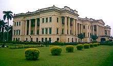
The Hazarduari Palace, or the palace with a thousand doors is the chief tourist attraction of Murshidabad. This three-storey palace was built in 1837 by Duncan McLeod for the Nawab Najim Humaun Jah, descendent of Mir Zafar. It has thousand doors (among which only 100 are real) and 114 rooms and 8 galleries, built in European architectural style. The total area of Hazarduari Palace is 41 acres (170,000 m2). It is now a museum and has a collection of armoury, splendid paintings, exhaustive portraits of the Nawabs, various works of art including beautiful works of ivory (Murshidabad school) of China (European) and many other valuables. The Armoury has 2700 arms in its collections of which only few are displayed. Swords used by Shiraj-ud-Daulla and his grandfather, Nawab Alivardi Khan, can be seen here. The other attractions in this floor are Vintage Cars and Fittan Cars used by the Nawabs and their families.
Wasef Manzil and other buildings and sites
Around the palace are other attractions like the Wasef Manzil (the New Palace) by the bank of the Ganges, Tripolia Gate, the Dakshin Darwaza, the Chak Darwaza, the Imambara, the Gharighar (the Clock Tower), the Bachchawali Tope (a canon) and the Madina, the only surviving structure built by Siraj-ud-Doula. The Bachchawali Tope (canon) was made between the 12th and the 14th century, probably by the Muslim rulers of Gaur.
The Royal Library
The library containing rare collections is not accessible to the public unless special permission is obtained. The building, rectangular on plan (424 feet Long and 200 feet (61 m) broad and 80 feet (24 m) high). The Palace was used for holding the "Durbar" or meetings and other official work of the Nawabs and also as the residence of the high ranking British Officials.
Festivals
Durga Puja, a five-day-long puja is the most important festival of the Hindus. Other pujas like Diwali, Kali puja, and Saraswati Puja are also celebrated here. Eid-ul-Fitr and Eid-ul-Adha (Bakri-eid, locally), Ashura are prominent Muslim festivities in this district.
Notable personalities
Literature
- Sarat Chandra Pandit (Dada Thakur)
- Nirupama Devi
- Moniruddin Khan
- Mahasweta Devi
- Syed Mustafa Siraj
- Manish Ghatak
- Nabarun Bhattacharya
- Ramendra Sundar Tribedi
- Paban Das Baul
History, Science & Culture
- Rakhaldas Bandyopadhyay
- Radhakamal Mukerjee
- Radha Kumud Mukherjee
- Ram Brahma Sanyal
- Syed Mustafa Siraj
- Arijit Singh
- Shreya Ghoshal
Educational Institutes
Educations Institutes in Murshidabad include:
Schools
- Lalgola M.N.Academy High School .
- Lalgola S.M.Girls High School
- Faridpur High school(H.S)(Faridpur, jalangi, murshidabad)
- Tikar Baria K.N. High school( Tikar Baria, Jalangi, Murshidabad)
- Chak Islampur S.C.M. High School, Islampur
- Dadpur High School[Dadpur,Murshidabad]
- Nashipur High Madrasah (H.S.), Islampur
- Giria High School, Giria, Jangipur
- Hareknagar A. M. Institution (H.S.), Hareknagar, Beldanga, Murshidabod
- Jangipur High School, Jangipur
- Jangipur Muniriah High Madrasah (H.S.), Jangipur
- Jangipur Girls High School, Jangipur
- Jotkamol High School, Jotkamol, Jangipur
- Raghunathganj Boys High School, Raghunathganj
- Raghunathganj Girls High School, Raghunathganj
- Kandi Raj High School, Kandi
- Kandi Raja Manindra Chandra Girl's High School, Kandi
- Bahara Adarsha Vidyapith, Kandi
- Jemo N.N High School, Kandi
- Delhi Public School, Farakka
- Farakka Barrage Project High School, Farakka
- J. N. Academy, Berhampore
- Maharani Kashiiswari Girls' High School, Berhampore
- Islampur Girls' High School, Islampur
- Gorabazar Iswar Chandra Institution, Berhampore
- Mahakali Pathshala (Girl's), Berhampore
- Gurudas Tarasundari Institution,Khagra, Berhampore
- Krishnath College School, Berhampore
- Lipika Memorial Girls' High School, Indraprastha, Berhampore
- Manindra Chandra Vidyapith, Berhampore
- Seva Milani Girls' High School, Berhampore
- Srish Chandra Girls' High School, Gorabazar, Berhampore,
- Beldanga C.R.G.S High School, Beldanga
- Nawab Bahadur's Institution, Lalbag, Murshidabad
- Lalbag M. M. C. Girls' High School, Lalbag, Murshidabad
- Singhi High School, Lalbag, Murshidabad
- Raja Bijay Singh High School, Jiaganj, Murshidabad
- Sargachi Ramakrishna Mission High School, Sargachi
- Bhabta Azizia High Madrasah
- Rasoroh Ambika High school
- Ahiran Hemangini Vidyaytan School (H.S.), Ahiran, Suti I, Murshidabad
- Sagardighi SN High School(H.S.), Sagardighi, Murshidabad
- Jitpur Paul Institution (H.S.), PO- Jitpur, Domkal, Murshidabad
- Nimtita G.D. Institution,Nimtita, murshidabad
- Aurangabad High School, Aurangabad
Colleges
- Krishnath College, Berhampore
- Berhampore Girls' College, Berhampore
- Sripat Singh College, Jiaganj
- Berhampore College, Berhampore
- Rani Dhanyakumari College, Jiaganj
- Subhas Chandra Bose Centenary College, Lalbag
- Dukhulal Nibaran Chandra College, Aurangabad, Murshidabad
- Kandi Raj College, Kandi, Murshidabad
- Raja Birendra Chandra College, Kandi, Murshidabad
- Sewnarayan Rameswar Fatepuria College, Beldanga
- Sagardighi Mahavidyalaya, Sagardighi
- Prof. Sayed Nurul Hassan College, Farakka
- Panchthupi Haripada Gouribala College, Panchthupi, Murshidabad
- Nur Mohammad Smriti Mahavidyalaya, Dhulian
- Nagar College, Nagar, Murshidabad
- Nabagram Amar Chand Kundu College, Nabagram, Murshidabad
- Murshidabad Adarsha Mahavidyalaya, Chalk Islampur, Murshidabad
- Muzaffar Ahmed Mahavidyalaya, Salar, Murshidabad
- Lalgola College, Lalgola
- Jatindra Rajendra Mahavidyalaya, Amtala, Murshidabad
- Jangipur College, Jangipur
- Jalangi Mahavidyalaya, Jalangi
- Hazi A.K. Khan College, Hariharpara, Murshidabad
- Dumkal College, Dumkal
- Domkal Girls’ College, Dumkal
- Union Christian Training College (B. Ed.), Berhampore
Engineering Colleges
- Government College of Engineering & Textile Technology, Berhampore
- Murshidabad Institute of Technology, Berhampore
- Murshidabad College of Engineering & Technology, Berhampore
- Jiaganj College of Engineering and Technology, Jiaganj
- Dumkal Institute of Technology, Dumkal
- Bcare Institute Of Management And Technology
- Jakir Hossain Institute of Polytechnic,Aurangabad
Medical College
Law College
- Kandi Raja Bimal Chandra College Of Law, Kandi
References
- ↑ "Murshidabad District : Census 2011 data". Census Organization of India. 2011. Retrieved 31 December 2013.
- ↑ Murshidabad Govt statistics page
- 1 2 3 4 5 6 7 "District Census 2011". Census2011.co.in. 2011. Retrieved 30 September 2011.
- ↑ "The story of Murshidabad".
- 1 2 3 Murshidabad Govt Website
- ↑ West Bengal Govt website on Murshidabad district
- ↑ Murshidabad
 This article incorporates text from a publication now in the public domain: Chisholm, Hugh, ed. (1911). "article name needed". Encyclopædia Britannica (11th ed.). Cambridge University Press..
 - ↑ Glossary of Meteorology, American Meteorological Society, Retrieved on 2006-09-05
- 1 2 Ministry of Panchayati Raj (8 September 2009). "A Note on the Backward Regions Grant Fund Programme" (PDF). National Institute of Rural Development. Retrieved 27 September 2011.
- ↑ Supreme Court Cracks Down on Overloading of Trucks
- ↑ "Population, Decadal Growth Rate, Density and General Sex Ratio by Residence and Sex, West Bengal/ District/ Sub District, 1991 and 2001". West Bengal. Directorate of census operations. Retrieved 12 November 2008.
- 1 2 "Directory of District, Sub division, Panchayat Samiti/ Block and Gram Panchayats in West Bengal, March 2008". West Bengal. National Informatics Centre, India. 19 March 2008. Retrieved 12 November 2008.
- ↑ "Census of India 2001, Final Population Totals, West Bengal, Rural Frame". West Bengal. Directorate of census operations. Retrieved 12 November 2008.
- ↑ "Statistical data". Official website of the Murshidabad district. Retrieved 12 November 2008.
- 1 2 3 4 "Press Note, Delimitation Commission" (PDF). Assembly Constituencies in West Bengal. Delimitation Commission. Retrieved 1 June 2009.
- ↑ "Press Note — Schedule for General Elections, 2009". Press Information Burueau, Government of India. Retrieved 1 June 2009.
- 1 2 3 4 5 "General election to the Legislative Assembly, 2001 – List of Parliamentary and Assembly Constituencies" (PDF). West Bengal. Election Commission of India. Retrieved 1 June 2009.
- ↑ US Directorate of Intelligence. "Country Comparison:Population". Retrieved 1 October 2011.
Bulgaria 7,093,635 July 2011 est.
- ↑ "2010 Resident Population Data". U. S. Census Bureau. Retrieved 30 September 2011.
Washington 6,724,540
- 1 2 3 4 "Census of India 2001". Provisional population totals, West Bengal, Table 4. Census Commission of India. Retrieved 21 May 2009.
- ↑ The Indian Census of 2001
- ↑
- ↑
- ↑
Further reading
- Lewis Sydney Steward O'Malley (1914). Murshidabad. Bengal secretariat book Department.
- John Henry Tull Walsh (1902). A History of Murshidabad District, Bengal. With Biographies of Some of Its Noted Families. With Map and Numerous Illustrations. London.
External links
 |
Sahebganj district, Jharkhand Pakur district, Jharkhand |
Malda district | Bangladesh | |
| Birbhum district | |
|||
| ||||
| | ||||
| Bardhaman district | Nadia district |
Cities, towns and locations in Murshidabad District | |||||||||||||||||||
|---|---|---|---|---|---|---|---|---|---|---|---|---|---|---|---|---|---|---|---|
| Cities, municipal and census towns |
| ||||||||||||||||||
| Locations other than cities and towns | |||||||||||||||||||
| Related topics |
| ||||||||||||||||||
Coordinates: 24°08′N 88°16′E / 24.14°N 88.26°E