Muottas Muragl
| Muottas Muragl | |
|---|---|
 View from Muottas Muragl towards Piz Ot | |
| Highest point | |
| Elevation | 2,454 m (8,051 ft) [1] |
| Coordinates | 46°31′18″N 9°54′09″E / 46.52167°N 9.90250°ECoordinates: 46°31′18″N 9°54′09″E / 46.52167°N 9.90250°E |
| Geography | |
 Muottas Muragl Location in Switzerland | |
| Location | Graubünden, Switzerland |
| Parent range | Livigno Alps |
| Climbing | |
| Easiest route | Funicular |
Muottas Muragl (2,454 m) is a location on the southern slopes of the Blais da Muottas (2,568 m), a summit at the western end of the range descending from Piz Vadret, in the Swiss canton of Graubünden. It overlooks the Engadin, between the towns of Samedan, St. Moritz and Pontresina. The mountain is within the municipality of Samedan.
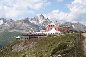
Muottas Muragl is accessible by a funicular railway, between Celerina and Pontresina, the Muottas Muragl Bahn, from the train stations Punt Muragl and Punt Muragl Staz, both served by the Rhaetian Railway. Muottas Muragl includes a hotel and a panoramic restaurant.
References
External links
![]() Media related to Muottas Muragl at Wikimedia Commons
Media related to Muottas Muragl at Wikimedia Commons
This article is issued from Wikipedia - version of the 1/29/2016. The text is available under the Creative Commons Attribution/Share Alike but additional terms may apply for the media files.