Mullewa, Western Australia
| Mullewa Western Australia | |
|---|---|
 Mullewa | |
| Coordinates | 28°32′13″S 115°30′43″E / 28.53694°S 115.51194°ECoordinates: 28°32′13″S 115°30′43″E / 28.53694°S 115.51194°E |
| Population | 425 (2006 census)[1] |
| Established | 1894 |
| Postcode(s) | 6630 |
| Elevation | 281 m (922 ft)[2] |
| Location | |
| LGA(s) | City of Greater Geraldton |
| State electorate(s) | Moore |
| Federal Division(s) | Durack |
Mullewa is a town in the Mid West region of Western Australia, 450 kilometres (280 mi) north of Perth and 98 kilometres (61 mi) east-northeast of Geraldton. Mullewa is well known for an abundance of wildflowers in spring and it is one of the few places in Western Australia that the wreath flower grows. The surrounding areas produce wheat and other cereal crops. The town is a receival site for Cooperative Bulk Handling.[3]
History
European settlers moved to the area in 1869 to take up pastoral leases for farming.[4] In 1894, the government built a narrow gauge railway from Geraldton to Mullewa and the town was gazetted in the same year.[4] The town is named for Mullewa Spring, based on an Aboriginal name recorded by surveyor John Forrest in 1873.[4] The meaning of the name is not certain, but the most accepted meaning is "place of fog".[4]
Church of Our Lady of Mt. Carmel and the Holy Apostles St. Peter and St. Paul and Priesthouse
The architect priest Mgr John Hawes built the Church mainly with his own hands and the help of parishioners. Work started in 1921 and the stone and tile church was completed, after some interruptions, in 1927. The eclectic design of the Church shows some influence of Spanish Mission style. Hawes built a presbytery for himself next to the church and this, known as the Priesthouse, was finished in 1929: it’s been used as a museum since 1980.
- Images of Our Lady of Mt. Carmel complex
 The Church, front
.jpg) Gargoyle on the Church
Gargoyle on the Church Church, side view
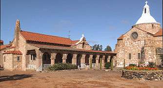 Priesthouse and Church
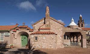 Priesthouse, street view
Rail service
One of the Western Australian Government Railways named overnight passenger services from Perth was known as The Mullewa, which ceased operation in 1974. Mullewa is the junction of the railway line northeast to Meekatharra, and south to Northam.[5]
Iron ore from the Tallering Peak mine is hauled by road 65 km to Mullewa, and loaded onto railway wagons for haulage 107 km to Geraldton where ships of up to 60,000 DWT are loaded.
Iron ore from the Karara mine will be hauled by rail, initially on narrow gauge trains, and later on standard gauge trains. The tracks from Karara to Mullewa are being laid with dual gauge sleepers.[6]
Media
Radio
Radio services available in Mullewa:
- ABC Midwest & Wheatbelt (6GN 828 AM) – Part of the ABC Local Radio Network.
- ABC Radio National – (6ABCRN 99.7 FM) – Speciality talk and music.
- Triple J – (6JJJ 98.9 FM) – Alternative music
- ABC News Radio – (6PNN 101.3 FM) – Rolling News bulletins, news magazine programs and LIVE coverage from Federal Parliament House of Representatives.
- WAFM (96.5FM) – Top 40 Music
- The Spirit Network (Radio 6BAY FM 98.1 \ 1512 AM) – Classic Hits / Adult Contemporary Music format aimed at 35 years + audience.
- Radio Mama- 100.5FM- Indigenous Community station
Television
Free-to-air broadcast television services available in Mullewa:
- Australian Broadcasting Corporation (ABC) – ABC1, ABC2, ABC3, ABC News 24 (digital channels)
- Special Broadcasting Service (SBS) – SBS One, SBS Two, SBS HD (digital channels)
- WIN Television, a dual affiliate of both the Nine Network and Network Ten.
- GWN7 (Golden West Network), an affiliate of the Seven Network.
The programming schedule is mainly the same as the Seven, Nine and Ten stations in Perth, with variations for news bulletins, sport telecasts such as the Australian Football League and National Rugby League, children's and lifestyle programs and advertorials. GWN7 produces a 30-minute regional news program each weeknight (originating from Bunbury) with a newsroom based in Geraldton, covering the local area.
Climate
Mullewa has a semi-arid climate with hot summers and mild to cool winters. The town features a dry summer/wetter winter routine, thus giving its climate some characteristics of the Mediterranean one.
| Climate data for Mullewa | |||||||||||||
|---|---|---|---|---|---|---|---|---|---|---|---|---|---|
| Month | Jan | Feb | Mar | Apr | May | Jun | Jul | Aug | Sep | Oct | Nov | Dec | Year |
| Record high °C (°F) | 47.3 (117.1) |
46.5 (115.7) |
44.0 (111.2) |
41.7 (107.1) |
35.5 (95.9) |
29.4 (84.9) |
28.9 (84) |
33.0 (91.4) |
37.6 (99.7) |
40.4 (104.7) |
43.2 (109.8) |
45.0 (113) |
47.3 (117.1) |
| Average high °C (°F) | 36.8 (98.2) |
36.4 (97.5) |
33.7 (92.7) |
28.7 (83.7) |
23.7 (74.7) |
19.9 (67.8) |
18.7 (65.7) |
20.1 (68.2) |
23.4 (74.1) |
27.1 (80.8) |
31.1 (88) |
34.4 (93.9) |
27.8 (82) |
| Average low °C (°F) | 19.4 (66.9) |
20.0 (68) |
18.3 (64.9) |
15.0 (59) |
11.1 (52) |
8.5 (47.3) |
6.9 (44.4) |
7.0 (44.6) |
8.5 (47.3) |
11.0 (51.8) |
14.3 (57.7) |
16.9 (62.4) |
13.1 (55.6) |
| Record low °C (°F) | 9.0 (48.2) |
10.0 (50) |
7.4 (45.3) |
5.0 (41) |
1.4 (34.5) |
−0.3 (31.5) |
−1.2 (29.8) |
−1.4 (29.5) |
0.0 (32) |
2.8 (37) |
6.0 (42.8) |
7.2 (45) |
−1.4 (29.5) |
| Average precipitation mm (inches) | 13.1 (0.516) |
18.6 (0.732) |
18.8 (0.74) |
21.2 (0.835) |
47.2 (1.858) |
64.6 (2.543) |
60.4 (2.378) |
42.2 (1.661) |
21.7 (0.854) |
13.0 (0.512) |
8.7 (0.343) |
8.5 (0.335) |
339.0 (13.346) |
| Average precipitation days | 2.3 | 2.4 | 2.5 | 3.8 | 7.1 | 10.3 | 11.2 | 9.6 | 6.1 | 4.1 | 2.3 | 1.9 | 63.6 |
| Source: [7] | |||||||||||||
References
- ↑ Australian Bureau of Statistics (25 October 2007). "Mullewa (L) (Urban Centre/Locality)". 2006 Census QuickStats. Retrieved 7 May 2008.
- ↑ http://www.altitude.nu/ Elevation at any place.
- ↑ "CBH receival sites" (PDF). 2011. Retrieved 1 April 2013.
- 1 2 3 4 Western Australian Land Information Authority. "History of country town names – M". Retrieved 7 May 2008.
- ↑ "The Demise of Mullewa as a Rail Centre" Milne, Rod Australian Railway Historical Society Bulletin, November, 1992 pp255-270
- ↑ http://gindalbie.com.au/our_projects/karara_iron_ore_project.phtml
- ↑ "Climate statistics for Mullewa". Bureau of Meteorology. Retrieved 15 October 2011.