Muleshoe, Texas
| Muleshoe, Texas | |
|---|---|
| City | |
|
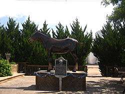
The National Mule Memorial at the Muleshoe Chamber of Commerce office | |
 Location of Muleshoe in Texas | |
| Coordinates: 34°13′35″N 102°43′25″W / 34.22639°N 102.72361°WCoordinates: 34°13′35″N 102°43′25″W / 34.22639°N 102.72361°W | |
| Country | United States |
| State | Texas |
| County | Bailey |
| Government | |
| • Mayor | Cliff Black |
| Area | |
| • Total | 3.4 sq mi (8.9 km2) |
| • Land | 3.4 sq mi (8.9 km2) |
| • Water | 0.0 sq mi (0.0 km2) |
| Elevation | 3,793 ft (1,156 m) |
| Population (2010) | |
| • Total | 5,158 |
| • Density | 1,500/sq mi (580/km2) |
| Time zone | CST (UTC-6) |
| • Summer (DST) | CDT (UTC-5) |
| ZIP code | 79347 |
| Area code | 806 |
| FIPS code | 48-49968 [1] |
| GNIS feature ID | 1375067 [2] |
| Website | City Website |
Muleshoe is a city in Bailey County, Texas, United States. The town of Muleshoe was founded in 1913 when the Pecos and Northern Texas Railway built an 88-mile (142 km) line from Farwell, Texas to Lubbock through northern Bailey County. In 1926, Muleshoe was incorporated. The population was 5,158 at the 2010 census. The county seat of Bailey County,[3] it is home to the National Mule Memorial.
The Muleshoe Heritage Center located off the combined U.S. Routes 70 and 84 is a popular museum which commemorates the importance of ranching to West Texas. The complex has several unique buildings originally from Bailey County that display the living conditions of the area in the late-19th century and the early to mid-20th century.
The Muleshoe National Wildlife Refuge is located some twenty miles (32 km) to the south on State Highway 214. Founded in 1935, the refuge is the oldest of its kind in the state of Texas. It is a 5,000-acre (20 km2) wintering area for migratory waterfowl flying from Canada to Mexico. It contains the largest number of sandhill cranes in North America.[4]
History
The name Muleshoe can be traced in the region to Henry Black when he registered a brand on November 12, 1860. In 1877, Black purchased three houses on a 40,000 acres (160 km2) in Stephens County, naming it Muleshoe Ranch. Later he built a large ranch house and a log schoolhouse, and established a small cemetery for family members.[5] Muleshoe Ranch was supposedly named after the owner found a mule shoe in the soil.
On April 23, 1906, the Gulf, Santa Fe and Northwestern Railway Company and the Pecos and Northern Texas Railway Company merged and were chartered to construct a railway between Lubbock, Texas and Farwell, Texas on the New Mexico border. From 1901 to 1915, communities along the future railway contributed hundreds of thousands of dollars to construction.[6] Muleshoe was founded in 1913 when the Pecos and Northern Texas Railway laid rails across northern Bailey county; residents borrowed the name from the nearby Muleshoe Ranch.[6]
Soon after the railroad passed through Muleshoe, the town expanded rapidly. In 1917 Muleshoe became the county seat after the county was organized, but it was not incorporated until 1926. Muleshoe continued to grow quickly, and by 1930 there were 800 residents in the town. Three decades later Muleshoe tripled in population to 3,871. In 1970 Muleshoe reached its pinnacle at over 5,000 residents, 200 businesses, two hospitals, two banks, a library, a newspaper, and a radio station.

During the 1970s and 1980s the population stagnated, and by the 1990s Muleshoe's population began to decrease. The population went from 5,048 in 1988 to 4,530 in 2000.[6] The once lively and vibrant Main Street is now quiet with many abandoned buildings. Many of the businesses that once called Main Street home are now on American Boulevard (US Highway 84/70).
During the early 1960s Texas residents were eager to build a memorial to the mule for his strength and sparse eating habits, traits which endeared him to the pioneers. In war, the mule carried cannon; in peace, he hauled freight. His small hooves allowed him to scale rocky areas.[7] The Mule Memorial was first displayed on July 4, 1965 near the intersection of US 70/84.[8] Muleshoe is the home of the world's largest mule shoe found at the Muleshoe Heritage Center.
Geography

Muleshoe is located at 34°13′40″N 102°43′46″W / 34.227816°N 102.729361°W.[9] with an elevation of 3,793 ft (1,156 m) above sea level. According to the United States Census Bureau, the city has a total area of 3.4 square miles (8.8 km2), all of it land. Muleshoe lies on the western extreme of the Central Standard Time Zone, just 17 miles (27 km) east of the Mountain Standard Time Zone.
Muleshoe is situated on he Great Plains in an area where the plains reach their highest altitude at the foot of the Rocky Mountains known as the High Plains; more specifically it is located on the South Plains in a region known as the Llano Estacado. The area topology is gently rolling plains with a large number of playa lakes on top of a large plateau. Many of the playa lakes have dried out due to the water exploitation of the Ogallala Aquifer that helped supply water to the lakes during dry seasons. Soil types vary from dark brown playa lake silt to iron rich clay to sandy soil; topsoil and subsoil layers vary as well. Most of the area contains a layer of caliche; in some areas there is no topsoil or subsoil revealing the layer of caliche while other places have up to four feet of topsoil or subsoil combined.
Muleshoe lies over the largest aquifer in the United States, the Ogallala Aquifer. The aquifer provides all of the city's water and is essential for the agriculture for the surrounding area. The aquifer is being depleted at an increasing rate over the years; this has triggered many changes in agriculture in efforts to preserve this natural resource.
The physical characteristics of the region makes Muleshoe an ideal place for agriculture. Much of the natural habitat of grasslands and shrubs has been replaced by cash crops and livestock, but a few areas of native fauna (called CRP) are preserved. About 20 miles (32 km) south of Muleshoe there is a system of sink lakes found at the Muleshoe National Wildlife Refuge. The refuge is a wintering area for large numbers of migratory waterfowl and sandhill cranes and preserves much of the native wildlife.
Climate
Muleshoe is in an area considered part of the semi-arid steppe climate zone that extends from areas of central Mexico to southern Alberta and Saskatchewan in Canada. The semi-arid steppe classifaction identifies areas that are intermediate between desert zones and humid zones. This West Texas town experiences hot summer days and cool summer nights and cool to warm winter days and harsh cold winter nights. Rainfall is low; the town and vicinity receive less than 18 inches (460 mm) of rainfall annually. High summer temperatures (average July temperature above 90 °F) precipitation moisture is rapidly lost to evaporation. Muleshoe experiences steady, and sometimes intense, winds from the north and west in the Fall and Winter and winds from the south or west in the Spring and Summer. The winds add a considerable wind chill factor in the winter.
Shortgrass prairie, prickly pear cacti and scrub vegetation are the most common flora to be seen around town. Agriculture in the forms of cattle ranching, dairy farming, and wheat and cotton farming are the most prevalent in the area.
| Climate data for Muleshoe, Texas | |||||||||||||
|---|---|---|---|---|---|---|---|---|---|---|---|---|---|
| Month | Jan | Feb | Mar | Apr | May | Jun | Jul | Aug | Sep | Oct | Nov | Dec | Year |
| Average high °F (°C) | 52 (11) |
57 (14) |
65 (18) |
73 (23) |
82 (28) |
90 (32) |
92 (33) |
90 (32) |
83 (28) |
74 (23) |
61 (16) |
53 (12) |
72.7 (22.5) |
| Average low °F (°C) | 20 (−7) |
24 (−4) |
30 (−1) |
39 (4) |
49 (9) |
58 (14) |
62 (17) |
61 (16) |
54 (12) |
41 (5) |
29 (−2) |
21 (−6) |
40.7 (4.8) |
| Average precipitation inches (mm) | 0.43 (10.9) |
0.50 (12.7) |
0.64 (16.3) |
1.01 (25.7) |
2.04 (51.8) |
2.49 (63.2) |
2.09 (53.1) |
3.07 (78) |
2.34 (59.4) |
1.50 (38.1) |
0.67 (17) |
0.59 (15) |
17.37 (441.2) |
| Source: [10] | |||||||||||||
Demographics
| Historical population | |||
|---|---|---|---|
| Census | Pop. | %± | |
| 1930 | 779 | — | |
| 1940 | 1,327 | 70.3% | |
| 1950 | 2,477 | 86.7% | |
| 1960 | 3,871 | 56.3% | |
| 1970 | 4,525 | 16.9% | |
| 1980 | 4,842 | 7.0% | |
| 1990 | 4,571 | −5.6% | |
| 2000 | 4,530 | −0.9% | |
| 2010 | 5,158 | 13.9% | |
| Est. 2015 | 5,185 | [11] | 0.5% |

As of the census[1] of 2010, there were 5,158 people, 1,595 households, and 1,178 families residing in the town. The population density was 1,323.9 people per square mile (511.4/km2). There were 1,802 housing units at an average density of 526.6 per square mile (203.4/km2). The racial makeup of the city was 63.27% White, 1.50% African American, 0.64% Native American, 0.20% Asian, 31.59% from other races, and 2.80% from two or more races. Hispanic or Latino of any race were 53.33% of the population.
There were 1,595 households out of which 38.6% had children under the age of 18 living with them, 61.3% were married couples living together, 8.8% had a female householder with no husband present, and 26.1% were non-families. 24.1% of all households were made up of individuals and 14.5% had someone living alone who was 65 years of age or older. The average household size was 2.80 and the average family size was 3.35.
In the city the population was spread out with 31.3% under the age of 18, 9.1% from 18 to 24, 25.1% from 25 to 44, 19.8% from 45 to 64, and 14.6% who were 65 years of age or older. The median age was 33 years. For every 100 females there were 92.8 males. For every 100 females age 18 and over, there were 90.8 males.
The median income for a household in the city was $25,519, and the median income for a family was $31,969. Males had a median income of $23,409 and females a median income $16,053. The per capita income for the city was $12,567. In 2007, the median house value was $48,748, and the average house value $66,525. In 2008 cost of living index in Muleshoe was 73.3 as compared to the U.S. average of 100. About 13.4% of families and 18.0% of the population were below the poverty line, including 21.9% of those under age 18 and 13.6% of those age 65 or over.
Recreation
In May 2010, Muleshoe opened a water park within the New City Park at 1611 West Avenue D. The facility has a large pool with a lazy river, diving board, and water slide. The park also offers soccer and softball fields, a playground, fishing pond, and basketball courts. City Secretary LeAnn Gallman said that the $1.8 million project originated in 2007, construction began in 2009 and was completed in 2010. The city had a previous 60-year-old pool.[13]
Education
Muleshoe is served by the Muleshoe Independent School District. Schools include:
- Muleshoe High School (Grades 9–12)
- Watson Junior High School (Grades 6–8)
- Mary DeShazo Elementary School (Grades 3–5)
- Neal B. Dillman Elementary School (Grades PK-2)
Over the past few years the Muleshoe Independent School District has expanded all of its campuses to accommodate the growing population of school aged children.The Muleshoe High School teams are known as "The Mules"; the school colors are black and white.
The Muleshoe Mules won the Division 1 2A football State Champions for the 2008–09 football season. This is the first State Champion title that the Mules have won so far.
There is also a branch of South Plains College which provides classes for students aspiring to become Licensed Vocational Nurses. The branch is located near the hospital.
Miscellaneous
The town is the home of the annual Tour de Muleshoe bicycle ride, a local competition which features 100K, 40-mile (64 km), and 10-mile (16 km) bike tours every year.
Muleshoe hosts one of the USArray Transportable Array seismic stations as part of the ongoing Earthscope project.[14]
Notable people
- Lee Horsley, Actor was born in Muleshoe on May 15, 1955. He played the fictional detective Matt Houston on an ABC series of the same name and later starred in the CBS western Paradise.
- Allan Weisbecker, writer, Surfer, lived briefly in Muleshoe during the late 1990s.
References
- 1 2 "American FactFinder". United States Census Bureau. Retrieved 2008-01-31.
- ↑ "US Board on Geographic Names". United States Geological Survey. 2007-10-25. Retrieved 2008-01-31.
- ↑ "Find a County". National Association of Counties. Retrieved 2011-06-07.
- ↑ Texas Historical Commission marker, Muleshoe National Wildlife Refuge, 1985
- ↑ "History of City/Area". City of Muleshoe. July 20, 1944. Retrieved 2013-11-08.
- 1 2 3 Hunt, William R. "Muleshoe, TX," Handbook of Texas Online, accessed November 8, 2013. Published by the Texas State Historical Association.
- ↑ Texas Historical Commission marker, National Mule Memorial
- ↑ "Muleshoe, Texas". Texas Online. July 4, 1965. Retrieved 2013-11-08.
- ↑ "US Gazetteer files: 2010, 2000, and 1990". United States Census Bureau. 2011-02-12. Retrieved 2011-04-23.
- ↑ "Average Weather for Muleshoe, Texas". The Weather Channel. Retrieved July 6, 2009.
- ↑ "Annual Estimates of the Resident Population for Incorporated Places: April 1, 2010 to July 1, 2015". Retrieved July 2, 2016.
- ↑ "Census of Population and Housing". Census.gov. Retrieved June 4, 2015.
- ↑ "Alyssa Dizon, "Muleshoe opens a new water park", May 29, 2010". Lubbock Avalanche-Journal. Retrieved May 29, 2010.
- ↑ "USArray Station Monitor – Station Viewer". Usarray.seis.sc.edu. Retrieved 2013-11-08.
External links
- City of Muleshoe
- Muleshoe Chamber of Commerce
- Muleshoe ISD
- Good Morning Muleshoe - GMM 7 News
- Handbook of Texas Online article
Municipalities and communities of Bailey County, Texas, United States | ||
|---|---|---|
| City |  | |
| Unincorporated communities | ||
| Ghost town | ||