Muhi
| Muhi | |
|---|---|
 Muhi Location of Muhi | |
| Coordinates: 47°58′40″N 20°55′46″E / 47.97789°N 20.92933°ECoordinates: 47°58′40″N 20°55′46″E / 47.97789°N 20.92933°E | |
| Country |
|
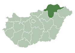
| County | Borsod-Abaúj-Zemplén |
| Area | |
| • Total | 9.62 km2 (3.71 sq mi) |
| Population (2004) | |
| • Total | 538 |
| • Density | 55.92/km2 (144.8/sq mi) |
| Time zone | CET (UTC+1) |
| • Summer (DST) | CEST (UTC+2) |
| Postal code | 3552 |
| Area code(s) | 46 |
Muhi is a village in Borsod-Abaúj-Zemplén county, Hungary.

Aerial photograph: Muhi, earth fort
The area has been inhabited since prehistoric times. In the thirteenth century, two villages stood here. In the Battle of Muhi in 1241, the Mongols decisively defeated the forces of King Béla IV of Hungary.
External links
- Street map (Hungarian)
This article is issued from Wikipedia - version of the 8/16/2016. The text is available under the Creative Commons Attribution/Share Alike but additional terms may apply for the media files.