Muggensturm
| Muggensturm | ||
|---|---|---|
| ||
 Muggensturm | ||
Location of Muggensturm within Rastatt district 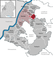
 | ||
| Coordinates: 48°52′21″N 08°16′46″E / 48.87250°N 8.27944°ECoordinates: 48°52′21″N 08°16′46″E / 48.87250°N 8.27944°E | ||
| Country | Germany | |
| State | Baden-Württemberg | |
| Admin. region | Karlsruhe | |
| District | Rastatt | |
| Government | ||
| • Mayor | Dietmar Späth | |
| Area | ||
| • Total | 11.56 km2 (4.46 sq mi) | |
| Population (2015-12-31)[1] | ||
| • Total | 6,179 | |
| • Density | 530/km2 (1,400/sq mi) | |
| Time zone | CET/CEST (UTC+1/+2) | |
| Postal codes | 76461 | |
| Dialling codes | 07222 | |
| Vehicle registration | RA | |
| Website | www.muggensturm.de | |

Muggensturm is a municipality in the district of Rastatt in Baden-Württemberg in Germany.
Geography

Muggensturm is sited in the Upper Rhine Plain at the foot of the Black Forest. The 27 km long Federbach flows through the town and the neighboring 43 ha nature reserve Federbachbruch.
The municipality borders Bietigheim, Malsch (district of Karlsruhe), Oberweier, Kuppenheim, Waldprechtsweier and Bischweier.
Muggensturm's area contains the municipality as well as the Ziegelhütte house in the Steinhardt and the lost settlements of Eichelbach and Frierlinde.[2]
History
The first mention of Muggensturm can be found in an official document of Pope Celestine III in the year 1193, where it is spelled Mugetstrum.
Politics
Municipal council

The 2009 local election resulted in the following composition of the municipal council (Gemeinderat):
- Free Voters (MBV) 38.8% (+11.0), 5 seats (+1)
- SPD 33.2% (+4.4), 5 seats (+1)
- CDU 27.9% (-0.9), 4 seats (=)
The voter participation was 54.1% (+0.2). Numbers in braces refer to the results of the previous local election.[3]
Town twinning
Muggensturm's twin town is Gradara in the Italian province of Pesaro and Urbino. It was established in 2002.[4] In 2011 an additional inner-German town twinning with Schönwalde-Glien (Brandenburg) was founded.
Culture
In 2005, the Bürgerband (citizen belt), a unique community photo album, was installed in the town hall. It shows around 2'500 Muggensturm citizens photographed by journalist Anton Jany.[5]
Every year at the end of July, the Muggensturm Volksfest attracts many visitors. Before 2011, local clubs would decorate waggons with up to 200'000 flowers and participate in a large pageant.[6]
Awards
In 2010, Muggensturm won the gold medal in the Entente Florale competition between municipalities. Entente Florale awards distinguished town development achievements.[7]
Infrastructure
Muggensturm is sited near the Bundesstraße 3 and the Rheintalbahn. It is connected to the Karlsruhe Stadtbahn.
References
| Wikimedia Commons has media related to Muggensturm. |
- ↑ "Gemeinden in Deutschland nach Fläche, Bevölkerung und Postleitzahl am 30.09.2016". Statistisches Bundesamt (in German). 2016.
- ↑ Das Land Baden-Württemberg. Amtliche Beschreibung nach Kreisen und Gemeinden. Band V: Regierungsbezirk Karlsruhe. Stuttgart: Kohlhammer. 1976. p. 180f. ISBN 3-17-002542-2.
- ↑ "2009 local election". Statistisches Landesamt Baden-Württemberg. Retrieved 25 October 2013.
- ↑ "Twin Town Partnership". Gemeinde Muggensturm. Retrieved 25 October 2013.
- ↑ "Kunst in Muggensturm". Gemeinde Muggensturm. Retrieved 25 October 2013.
- ↑ "Volksfest". Gemeinde Muggensturm. Retrieved 25 October 2013.
- ↑ "Participants since 2001". Entente Florale. Retrieved 25 October 2013.
Towns and municipalities in Rastatt (district) | ||
|---|---|---|