Muddy Mountains
| Muddy Mountains | |
|---|---|
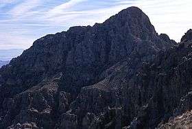 Muddy Peak, highpoint of the Muddy Mountains | |
| Highest point | |
| Peak | Muddy Peak |
| Elevation | 1,110 m (3,640 ft) |
| Geography | |
| Country | United States |
| State | Nevada |
| District | Clark County |
| Range coordinates | 36°23′34″N 114°39′01″W / 36.3928°N 114.6503°WCoordinates: 36°23′34″N 114°39′01″W / 36.3928°N 114.6503°W |
| Topo map | USGS Piute Point |

The Muddy Mountains are a mountain range in Clark County, Nevada.[1]
The Muddy Mountains surround a north section of Bitter Spring Valley, which also lies at the northwest perimeter of the Black Mountains, lying on a north shore of an east-west section of Lake Mead.
References
- 1 2 "Muddy Mountains". Geographic Names Information System. United States Geological Survey. Retrieved 2009-05-04.
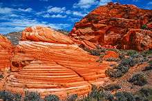
Cross bedding in Aztec Sandstone, Muddy Mountains Wilderness Area

Muddy Mountains seen from the Valley of Fire State Park, Nevada
This article is issued from Wikipedia - version of the 8/15/2014. The text is available under the Creative Commons Attribution/Share Alike but additional terms may apply for the media files.