Muang Soui
| Muang Suoi | |
|---|---|
| Town | |
 Muang Suoi | |
| Coordinates: 19°31′15″N 102°53′10″E / 19.52083°N 102.88611°E | |
| Country |
|
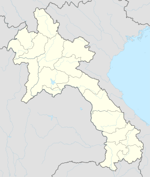
| Province | Xiangkhouang |
| Elevation | 1,097 m (3,599 ft) |
| Time zone | Laos Standard Time (UTC+7) |
Muang Soui (also called Muang Souy or Muong Soui) is a small town in Xiangkhouang Province in northeastern Laos. It is located along Route 7 , northwest of Phonsavan.
Laotian Civil War
Due to its location northwest of the strategic Plain of Jars, the town with its all weather runway (designated Lima Site 108 or LS-108) was a major base area for the Forces Armées Neutralistes (FAN) a "third force" in the Laotian Civil War from 1961 until 1966. The town was overlooked by the People's Army of Vietnam (PAVN) and Pathet Lao (PL) positions on the Phou Khout ridgeline. The FAN attempted unsuccessfully to take the Phou Khout ridgeline in Operation Triangle in July 1964[1] Following the disintegration of the FAN into pro and anti-communist forces in 1966, the town was effectively controlled by the Royal Lao Army. Captured by units of the PAVN 312th Division supported by PT-76 light tanks during the Campaign Toan Thang in June 1969.[2] Royalist forces supported by U.S. airpower tried unsuccessfully to recapture Muang Soui during Operation Off Balance in early July 1969.[3] The town was recaptured by Royalist forces in late September 1969 during Operation About Face.[4] After falling again to the Communists, it was recaptured by Royalist troops in Phou Khao Kham during August 1971.[5]
Notes
References
- Anthony, Victor B. and Richard R. Sexton (1993). The War in Northern Laos. Command for Air Force History. OCLC 232549943.
- Conboy, Kenneth and James Morrison (1995). Shadow War: The CIA's Secret War in Laos. Paladin Press. ISBN 0-87364-825-0.