Muak Lek District
| Muak Lek มวกเหล็ก | |
|---|---|
| Amphoe | |
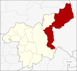 Amphoe location in Saraburi Province | |
| Coordinates: 14°39′20″N 101°11′54″E / 14.65556°N 101.19833°ECoordinates: 14°39′20″N 101°11′54″E / 14.65556°N 101.19833°E | |
| Country |
|
| Province | Saraburi |
| Seat | Muak Lek |
| Area | |
| • Total | 681.4 km2 (263.1 sq mi) |
| Population (2005) | |
| • Total | 49,572 |
| • Density | 73/km2 (190/sq mi) |
| Time zone | THA (UTC+7) |
| Postal code | 18180 |
| Geocode | 1911 |
Muak Lek (Thai: มวกเหล็ก) is a district (Amphoe) in the Saraburi Province of Thailand.
Geography
Muak Lek is the largest of the districts of Saraburi areawise, located in the east of the province. Neighboring districts are from the north clockwise Phattana Nikhom, Tha Luang and Lam Sonthi of Lopburi Province, Sikhio and Pak Chong of Nakhon Ratchasima Province, Mueang Nakhon Nayok of Nakhon Nayok Province, and Kaeng Khoi and Wang Muang of Saraburi.
The district is located within the hills of the Phetchabun Mountains, which separate central Thailand from the northeastern part (Isan). To the south of the district is the Khao Yai National Park.
History

The district was created on December 27, 1968, when the area of the former tambon Muak Lek in Kaeng Khoi district was split into three tambon containing 33 villages, and formed a new district named Muak Lek.[1] The new district started operation on January 21, 1969. On May 7, 1970 the permanent district office building was opened.
1988 the northwestern area was split off from the district to form the new Wang Muang minor district.
Traffic
The district is crossed by the Mittraphap Road and the northeastern railway line on their way through the hills.
Administration
The district is subdivided into 6 subdistricts (tambon), which are further subdivided into 65 villages (muban). Muak Lek itself has township status (thesaban tambon) and covers parts of tambon Muak Lek and Mittraphap. There are 6 tambon administrative organizations (TAO).
| No. | Name | Thai name | Villages | Pop. |
|---|---|---|---|---|
| 1. | Muak Lek | มวกเหล็ก | 13 | 9,925 |
| 2. | Mittraphap | มิตรภาพ | 10 | 10,448 |
| 4. | Nong Yang Suea | หนองย่างเสือ | 14 | 6,318 |
| 5. | Lam Somphung | ลำสมพุง | 10 | 4,468 |
| 7. | Lam Phaya Klang | ลำพญากลาง | 18 | 11,305 |
| 9. | Sap Sanun | ซับสนุ่น | 15 | 7,108 |
the missing numbers 3, 6 and 8 were the tambon which now form Wang Muang.
Education
There are a number of schools on Muak Lek including the local public high school Muak Lek Wittaya School.
Asia-Pacific International University (formerly Mission College) and its affiliated K-12 school Adventist International Mission School are located within the vicinity and cater to both the expat community and locals. They are part of the world-wide Seventh-Day Adventist education system, the second largest parochial school system in the world.
References
- ↑ พระราชกฤษฎีกาตั้งอำเภอมวกเหล็ก พ.ศ. ๒๕๑๑ (PDF). Royal Gazette (in Thai). 85 (121 ก): 1051–1053. December 31, 1968.
- http://www.muaklek.net
- http://www.saraburi.go.th/file/am-muak.doc (Thai winword file)