Mua District
| Mua Mu'a | |
|---|---|
| District | |
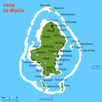 Map of Wallis Island showing the 3 districts: Mua is located in south | |
| Coordinates: 13°20′25″S 176°11′30″W / 13.34028°S 176.19167°WCoordinates: 13°20′25″S 176°11′30″W / 13.34028°S 176.19167°W | |
| Country |
|
| Territory |
|
| Island | Wallis |
| Chiefdom | Uvea |
| Capital | Mala'efo'ou |
| Area | |
| • Total | 26,3 km2 (102 sq mi) |
| Population (2008) | |
| • Total | 3,265 |
| Time zone | UTC+12 |
| No. of municipalities | 10 |
Mua (also spelled Mu'a, Uvean for "first") is one of the 5 districts of Wallis and Futuna, located in Wallis Island, in the Pacific Ocean. It is part of the Chiefdom of Uvea.
Geography
Located in the southern side of the island, Mua borders with the districts of Hahake. Mala'efo'ou (formerly named Mu'a) is the administrative seat.
The districts is divided into 10 municipal villages:[1]
| Village | Population |
|---|---|
| Utufua | 736 |
| Halalo | 637 |
| Vaimalau | 529 |
| Lavegahau | 379 |
| Teesi | 284 |
| Malaefoou | 279 |
| Gahi | 271 |
| Tepa | 246 |
| Haatofo | 239 |
| Kolopopo | 176 |
See also
References
- ↑ Municipal population of the villages in Wallis and Futuna (INSEE 2008, complete list)
External links
| Wikimedia Commons has media related to Chiefdoms and districts of Wallis and Futuna. |
- Google (4 September 2013). "Mua District" (Map). Google Maps. Google. Retrieved 4 September 2013.
Wallis and Futuna articles | |||
|---|---|---|---|
| Islands |  | ||
| Chiefdoms | |||
| Geography | |||
| Politics | |||
| Economy | |||
| Culture | |||
| |||
This article is issued from Wikipedia - version of the 4/16/2016. The text is available under the Creative Commons Attribution/Share Alike but additional terms may apply for the media files.