Mount Vernon, Illinois
| Mount Vernon | |
| Mt. Vernon | |
| City | |
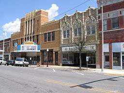 Town Center of Mount Vernon | |
| Motto: Mt. Vernon, City of Opportunity.[1] | |
| Nickname: The King City | |
| Country | United States |
|---|---|
| State | Illinois |
| County | Jefferson |
| Townships | Mount Vernon, Shiloh, Dodds, McClellan |
| Coordinates | 38°18′49″N 88°54′29″W / 38.31361°N 88.90806°WCoordinates: 38°18′49″N 88°54′29″W / 38.31361°N 88.90806°W |
| Area | 13.15 sq mi (34 km2) |
| - land | 13.07 sq mi (34 km2) |
| - water | 0.08 sq mi (0 km2) |
| Population | 15,277 (2010) |
| Density | 1,412.1/sq mi (545/km2) |
| Founded | 1817 |
| Mayor | Mary Jane Chesley |
| Timezone | CST (UTC−6) |
| - summer (DST) | CDT (UTC−5) |
| Postal code | 62864 |
| Area code | 618 |
  Location of Mount Vernon within Illinois | |
| Wikimedia Commons: Mount Vernon, Illinois | |
| Website: http://mtvernon.com | |
Mount Vernon known as "The King City" is a city in and the county seat of Jefferson County, Illinois, United States.[2] The population was 15,277 at the 2010 census.
Mount Vernon is the principal city of the Mount Vernon Micropolitan Statistical Area, which includes all of Jefferson and Hamilton counties.
History
19th century

Mt. Vernon was founded in 1817 by Zadok Casey, who was elected to the State Senate in 1822 and was elected Lieutenant Governor in 1833. He served in the U.S. Congress between 1833 and 1843. The town was named for George Washington's plantation, Mount Vernon, which was named for Edward Vernon, a British naval hero.
When the town was founded, there was no road to it. Travelers had to get there by either following the high ground from the north or crossing the swamps from the south. In the early 19th century the Goshen Road crossed Illinois in a northwesterly direction from Old Shawneetown, Illinois to the Goshen Settlement, near what is now Edwardsville. This road was the main road in Illinois. When Mt. Vernon was first settled, the Goshen Road made a wide arc across Jefferson County, crossing Casey Creek and the Big Muddy north of Mt. Vernon, avoiding the swamps to the south, but bypassing Mt. Vernon. The road entered the county at its southeast corner. It passed through, or near, what are now Opdyke, East Salem, Idlewood, Dix and Walnut Hill. However, it was apparent to the early settlers that the town would fail without roads. In 1820–1821, Ben Hood and Carter Wilkey built a bridge over Casey Creek, to the southeast of town. This bridge was near the present bridge on Illinois Route 142. A road was built from there northwest, over ground that is now impassable, toward the old cemetery behind the modern Bethel Cemetery. Deep cuts through the old cemetery attest to the location of the road. From there the road probably followed modern Route 37 into town, somewhere shifting from 10th Street on west to 12th Street.
After the state capitol was moved to Vandalia in 1819, it became apparent that a road to Vandalia was needed. A party was sent out to the northwest to mark the road. In 1823, Thomas D. Minor and William Maxwell built the "Vandalia Road", now called the "Old Centralia Road." It runs northwest out of Mt. Vernon to Walnut Hill. Although legend says that this road is crooked because of the drunken state of the surveyors, the path is probably just the natural path of a pioneer road following the terrain. After the bridge and the Vandalia Road were built, Mt. Vernon was "on the map." The bridge across Casey Creek and the Vandalia Road provided a much shorter path across Jefferson County than the original Goshen Road. The new Goshen Road soon captured most of the traffic, and Mt. Vernon became an important stop on the road west.
In 1836, Joshua Grant came to Mt. Vernon from Christian County, Kentucky with several of his sons and daughters. His family was an extremely wealthy, southern, slave-owning family, most of which soon moved to Arkansas, probably because slavery was illegal in Illinois. Joshua left behind several daughters and one son, Angus McNeil Grant, who soon became extremely important in the development of the town. "Upon his arrival, there were but four or five houses in the place, and from that time to the present (1883) he has constantly and ably exerted himself in securing to it the full development of its resources." Angus M. Grant's brother, Joshua Jr. taught school in Mt. Vernon in 1838. Some sources cite him as the first schoolteacher in the town.
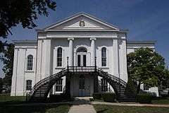
In 1848, the Illinois Supreme Court was relocated to Mt. Vernon at what is currently 14th and Main Streets. The 5th District Appellate Court was constructed in 1854 according to the National Register of Historic Places and is still in use as the Appellate Court House. When the Supreme Court was in session, the important lawyers in Illinois, including Abraham Lincoln, gathered in Mt. Vernon to argue their cases. The lawyers gathered at the Mt. Vernon Inn, owned by Angus McNeil Grant and his in-laws, the Andersons. This building has been on the National Register of Historic Places since July 2, 1973.[3]
In the 1870s, Mt. Vernon for a time prohibited the sale of alcohol. A village called "East Mt. Vernon" was organized in 1877 to allow the sale of alcohol. A court fight eventually held that the village was organized illegally. Mt. Vernon then voted alcohol back in, and the area of East Mt. Vernon was annexed into the city.
On February 19, 1888, a tornado cut a path a half mile wide through Mt. Vernon, killing 37 people and destroying more than 450 houses. The Jefferson County Courthouse was destroyed. This event was one of the first disasters to which the American Red Cross responded. Clara Barton herself directed the relief efforts.
The Mt. Vernon Car Manufacturing Company opened in 1889 after moving from Litchfield, Illinois. This relocation may have been an outgrowth of the relief efforts following the tornado. The Louisville and Nashville Railroad hauled in some 1,900 carloads of supplies for reconstruction of the town. Somehow, this effort translated into a major business building railroad cars, at first building about ten cars per day. By 1909, the car shops were producing 25 cars per day, employing more than 1000 workers, with a payroll of $60,000 per month.
20th and 21st centuries
During World War II, portions of the "Car Shops", as they had to come to be known, were converted over to wartime production, including the production of bomb casings. Around 1939, a portion of the car shops was purchased by Precision Engineering, which originally built components for locomotives. During the 1970s, this company purchased old diesel/electric railroad locomotives, which it scrapped out or refurbished. Today, the plant thrives as a hub for National Railway Equipment Company[4] which rebuilds and services diesel electric locomotives for rail lines across the globe. Ironically, the facility is poised to again become one of the area's largest employers as sales of its innovative hybrid locomotives fuel plant expansion to include another facility across town.
In 1954, the car shops closed, causing a temporary jump in unemployment throughout the city and the 108 communities called "home" by its former employees.
The Interstate Highway System was built in the late 1950s and 1960s. The concurrency of I-57 and I-64 is along the western border of the ridgeline which divides the Big Muddy River and Casey Creek. The stack interchange on the southwest side of town complements the historic Casey Creek bridges, allowing much shorter travel times through the swamps to the east and south.
In April 2007, Mount Vernon voters elected the first female mayor[5] of the city, Mary Jane Chesley. She was sworn into office on May 7, 2007.[6]
Geography
Mount Vernon is located at 38°18′49″N 88°54′29″W / 38.313512°N 88.908159°W.[7]
According to the 2010 census, Mount Vernon has a total area of 13.151 square miles (34.06 km2), of which 13.07 square miles (33.85 km2) (or 99.38%) is land and 0.081 square miles (0.21 km2) (or 0.62%) is water.[8]
The community is about 80 miles (130 km) east of St. Louis, Missouri.[9]
Mt. Vernon is located on high ground between Casey Creek and the Big Muddy River, which join south of the town in what is now Rend Lake. In pre-settlement times the area around these waterways was a swamp, a heavily forested area that was waist-deep in water during much of the winter and during wet summers. Mt. Vernon was thus often surrounded by water and swamp on three sides.
High ground was located to the north of Mt. Vernon. A ridge ran between the Big Muddy River and Casey Creek north toward what is now Dix.
There are high places both west and east of Mt. Vernon from which one can see the town as a forested point of high ground jutting out into the bottoms. These high places are: from the west, near the Woodlawn interchange off Interstate 64 and from the east, on Old Fairfield Road near Summersville School, with the highest point located on Old Route 15 right before it merges with New Route 15, near Bluford.
Demographics
| Historical population | |||
|---|---|---|---|
| Census | Pop. | %± | |
| 1860 | 707 | — | |
| 1870 | 1,167 | 65.1% | |
| 1880 | 2,324 | 99.1% | |
| 1890 | 3,233 | 39.1% | |
| 1900 | 5,216 | 61.3% | |
| 1910 | 8,007 | 53.5% | |
| 1920 | 9,815 | 22.6% | |
| 1930 | 12,375 | 26.1% | |
| 1940 | 14,724 | 19.0% | |
| 1950 | 15,600 | 5.9% | |
| 1960 | 15,566 | −0.2% | |
| 1970 | 16,270 | 4.5% | |
| 1980 | 17,193 | 5.7% | |
| 1990 | 16,988 | −1.2% | |
| 2000 | 16,269 | −4.2% | |
| 2010 | 15,277 | −6.1% | |
| Est. 2015 | 15,087 | [10] | −1.2% |
As of the census[12] of 2010, there were 15,277 people, 6,702 households and 3,781 families residing in the city. The population density was 1,168.7 people per square mile (545.3/km²). There were 7,534 housing units. The racial makeup of the city was 80.6% White, 14.7% African American, 0.3% Native American, 1% Asian, 0.0% Pacific Islander, and 2.6% from two or more races. Hispanic or Latino of any race were 2.4% of the population.[12]
There were 6,702 households out of which 25.8% had children under the age of 18 living with them, 35% of all households were married couples living together, 16.3% had a female householder with no husband present, and 43.6% were non-families. 37.6% of all households were made up of individuals and 16.1% had someone living alone who was 65 years of age or older. The average household size was 2.23 and the average family size was 2.92.[12]
In the city the population was spread out with 24.3% under the age of 18, 6.2% from 20 to 24, and 18% who were 65 years of age or older. The median age was 38.3 years. Males represent 46.5% of the population, and 34% of the population was male and over 18. Women were 53.5% of the population, 41% of the population being female and over 18.[12]
The median income for a household in the city was $32,549, and the median income for a family was $36,660. Males had a median income of $28,324 versus $16,497 for females. The per capita income for the city was $21,283. About 19.9% of families and 23.7% of the population were below the poverty line, including 35.4% of those under age 18 and 11.7% of that age 65 or over. 53.9% of households earn less than $35,000.[12]
Of the population over age 25, 72.7% have no college degree. 13.6% of those over 25 have no high school diploma nor equivalent. 7.6% of the population has a bachelor's degree or higher.[12]
According to the US Census, health care services and social services employ the second most people with 1,001 estimated jobs. Accommodation and food services (restaurants) are the highest employer with 1,146 estimated jobs.[12]
Economy
Mount Vernon hosts a 48-acre (190,000 m2) facility for Continental Tire of North America.It is also home to major distribution centers for NAPA, National Railway Equipment(NREC), ALCO and IPT (subsidiaries of NREC), and Walgreens along with many other smaller industries such as Vanex, Central Wholesale Liquors, IL-MO Welding supplies, Pepsi of Mid America, A.L. LEE Corporation, Goodman Air Conditioning, US Supply Co, Mine Supply Company, National Fabrication, IBT, Bearing Headquarters, Mt. Vernon Mold Works, Wiese Forklift Service Center, Black Forklift Service Center, Penske, Beelman Trucking, Clinton County Ready-Mix, Calison Wholesale Liquor, Praxair, Ultron Electronics, FedEx, UPS/Overnite, Springfield Electric, Mt. Vernon Electric, Roadway Express, Guaranteed Freight, Bennett Metals, Sun Container, Three-States Supply Co, Phoenix Modular Elevator Company and Petter Trucking, which are located in or within close proximity to the city's three industrial parks. There is discussion of creating a fourth industrial park which is to be used for distribution centers in the area of the new interchange, this park would encompass 100 acres (0.40 km2) and would be eligible for Tax Increment Financing and Enterprise Zone benefits.[13]
Development includes a Kohl's Department Store which opened early 2011 and Buffalo Wild Wings which opened December 19, 2010. Two new TIF (Tax Increment Financing) districts have been created, one TIF is at Exit 95 and is a conservation/industrial use. Exit 94 is an Industrial Park Conservation TIF.[14] Pepsi has built a new service and distribution center that was completed in March 2011, it is located off of the Davidson Avenue extension.
Top employers
According to Mount Vernon's 2014 Comprehensive Annual Financial Report,[15] the top employers in the city are:
| # | Employer | # of Employees |
|---|---|---|
| 1 | Continental Tires the Americas | 3,200 |
| 2 | Walgreens Distribution Center | 1,500 |
| 3 | Good Samaritan Hospital | 1,130 |
| 4 | Crossroads Community Hospital | 325 |
| 5 | Mount Vernon City Schools, District 80 | 260 |
| 6 | National Railway Equipment Company | 200 |
| 7 | Mt. Vernon Township High School | 172 |
| 8 | City of Mount Vernon | 134 |
| 9 | United Methodist Children's Home | 114 |
| 10 | Orthopaedic Center of Southern Illinois | 100 |
| 11 | Magnum Steel Works | 100 |
| 12 | InnoTech Manufacturing | 100 |
| 13 | Everbrite | 100 |
| 14 | Genuine Parts/NAPA Distribution Center | 90 |
Arts and culture
Mount Vernon is home to Cedarhurst[16] which is a 90-acre site. Cedarhurst celebrates the arts year-round with visual and performing arts programs for the public. The Cedarhurst Craft Fair[17] is held yearly in early September on the grounds. In addition to its programs on property, the Mitchell Museum is located on the CedarHurst grounds.
The city is host to an event the first Saturday of each month from April through October called Market Days.[18] This is an open-air market held near downtown and is similar to a craft fair or flea market.
There is also the Jefferson County Historical Museum and Village located within incorporated Mount Vernon. The Museum and the Village reflect life in Jefferson County from the mid 19th century to more recent years.[19]
The C.E.Brehm Memorial Public Library, built in 1905, is a source of information to the community and is located downtown.[20]
Beatles guitarist, George Harrison once bought a guitar from Fenton's Music store in Mt. Vernon in 1963 while he was visiting his sister in nearby Benton, Illinois. The guitar sold at auction for $657,000 in 2014.[21]
Parks
- Mount Vernon has multiple community parks with varying amenities.[22]
- Wayne Fitzgerrell State Recreation Area is located due south near Benton, Illinois. Rend Lake has almost 19,000 acres of water area for recreation including boating, fishing, camping, and a resort.
Government
Local government
The city of Mount Vernon uses a Council-manager government with a mayor.[23] The Mt. Vernon City Council meets regularly on the first and third Mondays each month. Meetings are moved to the following Tuesday if the first or third Monday falls on a holiday.[23]
The elective officers of the City of Mt. Vernon shall be a Mayor, four Councilmen, a City Clerk, and a City Treasurer. At the general election for City officers to be starting in January 1969 and every four years thereafter, there shall be elected a Mayor, City Clerk, City Treasurer, and two Councilmen. At the general election held in 1967 and every two years thereafter, two Councilmen shall be elected.[24]
The current mayor and council are:[25]
- Mayor – Mary Jane Chesley
- Council – Donte Moore, Dennis McEnaney, Todd Piper, and Jeff May.[26]
Crime
| Year | State | Months | Population | Violent Crime Rate | Murder and nonnegligent manslaughter rate | Forcible rape rate | Robbery rate | Aggravated assault rate | Property crime rate | Burglary rate | Larceny-theft rate | Motor vehicle theft rate |
|---|---|---|---|---|---|---|---|---|---|---|---|---|
| 2012 | IL | 12 | 15,243 | 1,246.5 | 0 | 124.6 | 170.6 | 951.3 | 5,878.1 | 1,430.2 | 4,336.4 | 111.5 |
Education
Mount Vernon City Schools operates elementary and middle schools. There are four education centers operated by school district 80 within the city:[28]
- Dr. Andy Hall Early Childhood Center which educates preschool children.
- Mount Vernon City Schools Primary Center which includes grades K-3.
- J.L. Buford Intermediate Education Center which includes grades 4 and 5.
- Zadok Casey Middle School which educates grades 6-8.
Mount Vernon Township High School is the community high school.
Area colleges and universities:
Media
Newspapers
- Mt. Vernon Register-News is located in downtown Mount Vernon serving the city and surrounding county.
- The Morning Sentinel (Mount Vernon, Illinois) is a daily newspaper located within the city that covers local, countywide, and regional news.
Radio
- WMIX (AM) is an AM frequency radio station operating within the city and owned by Withers Broadcasting.
- WMIX-FM is an FM radio station with a country music format on 94.1 MHz.
- WDML is an FM radio station with an adult rock & roll format on 106.9 MHz.
Television
- WPXS is a television station broadcasting north of Mount Vernon operating on digital channel 21 and virtual channel 13.
Transportation
Roads and highways
-
 I-57 runs north and south and is local
 -
 I-64 runs east and west and is local
 -
 IL 37 runs north and south and is local
 -
 IL 15 runs east and west and is local
Airports
- The Mount Vernon Airport has a 6500-foot main runway, fixed-base operation, terminal building and storage hangars. Charter and private aviation services are provided, as well as refueling. The facility offers Shell 100 and Jet A fuels and pilot lounge with weight and exercise room, shower and snooze rooms, wireless internet in the airport terminal, complimentary refreshments, courtesy shuttle, as well as overnight hangar reservations.[29]
- MidAmerica Airport, a cargo airport approximately 45 miles from Mt. Vernon, located in Mascoutah, Illinois along Interstate 64.
Railroad service
Motor freight
- UPS Freight
- FedEx Freight
- Direct Motor Freight
Bus service
Notable people
- Dwight Bernard, pitcher for the Milwaukee Brewers and New York Mets
- Ray Blades, left fielder for the St. Louis Cardinals; manager for the Cardinals and Brooklyn Dodgers[36]
- Louis Emmerson, 29th Governor of Illinois from 1929–1933
- Randy Fenoli, television presenter and fashion designer
- Crista Flanagan, comedic actress, roles including MADtv and Mad Men
- Walt Kirk, University of Illinois and pro basketball player
- Jeane Kirkpatrick, US ambassador to the United Nations; graduated from Mt. Vernon Township High School
- Ben Moses, TV producer, writer, director, filmmaker
- Charles W. Pavey, Illinois businessman and politician
- Kenny Troutt, Founder and CEO, Excel Communications
- Albert Watson, Illinois Supreme Court justice
- Albert Watson, II, US Army lieutenant general during World War II
- Jane Willis, attorney, member of blackjack team featured in New York Times best-selling book Bringing Down the House and the film 21 (2008 film)
References
- ↑ "Jefferson County History". Jefferson County IL Website. Jefferson County. Retrieved 4 August 2015.
- ↑ "Find a County". National Association of Counties. Retrieved 2011-06-07.
- ↑ "National Registry of Historic Places". National Registry of Historic Places. United States Government. Retrieved 3 October 2014.
- ↑ Nationalrailway.com Archived November 22, 2014, at the Wayback Machine.
- ↑ "Chesley Wins Mayoral Race". Mt. Vernon Register-News. Retrieved 2015-01-09.
- ↑ "King City Swears In First Woman Mayor". Mt. Vernon Register-News. Retrieved 2015-01-09.
- ↑ "US Gazetteer files: 2010, 2000, and 1990". United States Census Bureau. 2011-02-12. Retrieved 2011-04-23.
- ↑ "G001 - Geographic Identifiers - 2010 Census Summary File 1". United States Census Bureau. Retrieved 2015-12-27.
- ↑ Botelho, Greg and Nick Valencia. "7-year-old survives plane crash that kills 4 in Kentucky." CNN. January 2, 2015. Retrieved on January 5, 2015.
- ↑ "Annual Estimates of the Resident Population for Incorporated Places: April 1, 2010 to July 1, 2015". Retrieved July 2, 2016.
- ↑ "Census of Population and Housing". Census.gov. Retrieved June 4, 2015.
- 1 2 3 4 5 6 7 "American FactFinder". United States Census Bureau. Retrieved 2014-09-22.
- ↑ "Mt. Vernon Enterprise Zones". City of Mount Vernon. Retrieved 30 September 2014.
- ↑ "JCDC TIF Information". Jefferson County Development Corporation. JCDC. Retrieved 3 October 2014.
- ↑ City of Mount Vernon CAFR
- ↑ Cedarhurst http://www.cedarhurst.org/. Retrieved 25 September 2014. Missing or empty
|title=(help) - ↑ Cedarhurst Craft Fair http://www.cedarhurst.org/index.php?page=craft-fair. Retrieved 25 September 2014. Missing or empty
|title=(help) - ↑ Mount Vernon Market Days http://enjoymtvernon.com/catablog-items/mt-vernon-market-days/. Missing or empty
|title=(help) - ↑ Jefferson County Historical Society http://www.jchs.mvn.net/. Retrieved 25 September 2014. Missing or empty
|title=(help) - ↑ CE Brehm Memorial Library http://www.mtvbrehm.lib.il.us/. Retrieved 25 September 2014. Missing or empty
|title=(help) - ↑ "Beatles Rickenbacker Guitar Bought in Illinois Fetches $657K at Auction". NBC Chicago. NBC. May 19, 2014. Retrieved 2015-01-19.
- ↑ "Mount Vernon Parks". City of Mount Vernon. Retrieved 3 October 2014.
- 1 2 "City Government Information". City of Mount Vernon. City of Mount Vernon. Retrieved 13 March 2015.
- ↑ Mt. Vernon City Ordinances Article 1, Section 1.1 (a)
- ↑ "City Council Information". City of Mount Vernon. City of Mount Vernon. Retrieved 13 March 2015.
- ↑ "New Council Members Seated". Mt. Vernon Register-News. CNHI. Retrieved 12 May 2015.
- ↑ Uniform Crime Reporting Statistics. Federal Bureau of Investigation http://www.ucrdatatool.gov/Search/Crime/Local/RunCrimeOneYearofData.cfm. Retrieved 13 July 2015. Missing or empty
|title=(help) - ↑ Home page. Mount Vernon City Schools. Retrieved on January 5, 2015.
- ↑ Mt. Vernon Airport http://www.mtvernonairport.com/. Retrieved 30 September 2014. Missing or empty
|title=(help) - ↑ "EVWR Website". Evansville Western Railroad. Retrieved 3 October 2014.
- ↑ "Norfolk Southern Website". Norfolk Southern Incorporated. Retrieved 3 October 2014.
- ↑ "Union Pacific Website". Union Pacific Railroad. Retrieved 3 October 2014.
- ↑ "BNSF Website". Burlington-Northern Santa Fe. Retrieved 3 October 2014.
- ↑ "Greyhound Bus Website". Greyhound. Retrieved 3 October 2014.
- ↑ "SCMTD Website". South Central Mass Transit District. Retrieved 3 October 2014.
- ↑ "Ray Blades". Players. MLB Advanced Media, L.P. Retrieved 30 June 2012.
- History of Jefferson County, Illinois, William Henry Perrin, 1883
- Mt. Vernon Illinois A Pictorial History, Thomas A. Puckett, 1991, Bradley Publishing company
External links
| Wikimedia Commons has media related to: |
- Official website
- History of Jefferson County, Illinois (1883)
- Wall's History of Jefferson County, Illinois (1909)
- History of Jefferson County
- Register-news.com
- WDML 106.9FM Radio Website
- WMIX Radio Website
- Mount Vernon Township High School
- Mitchell Museum at Cedarhurst Center for the Arts
Municipalities and communities of Jefferson County, Illinois, United States | ||
|---|---|---|
| Cities | ||
| Villages | ||
| Townships | ||
| CDP | ||
| Other unincorporated communities |
| |
| Footnotes | ‡This populated place also has portions in an adjacent county or counties | |
| Counties | 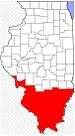 | |
|---|---|---|
| Mid-sized cities (25,000+) | ||
| Small Cities (10,000-25,000) | ||
| Small Cities (5,000-10,000) | ||
| Interstates | ||
| Airports/Military bases |
| |
| Universities | ||
| Colleges | ||
| Sports teams based in the Southern Illinois | ||