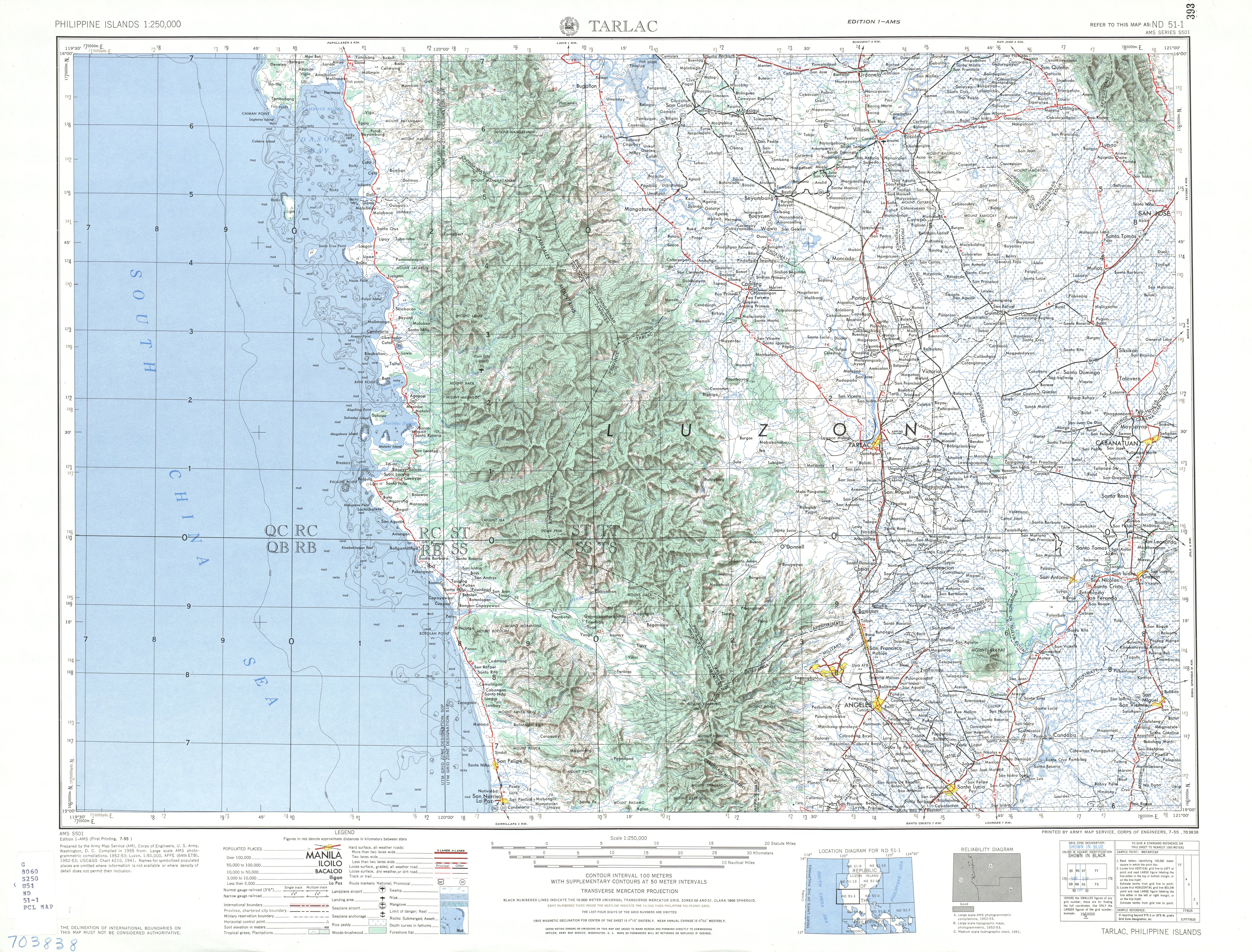
Mount Pinatubo
| Mount Pinatubo | |
|---|---|
 | |
| Highest point | |
| Elevation |
1,486 m (4,875 ft) (current) 1,745 m (5,725 ft) (before 1991 eruption) |
| Listing | Active volcano |
| Coordinates | 15°08′30″N 120°21′00″E / 15.14167°N 120.35000°ECoordinates: 15°08′30″N 120°21′00″E / 15.14167°N 120.35000°E |
| Naming | |
| Pronunciation | /ˌpiːnəˈtuːboʊ/ |
| Geography | |
.svg.png) Mount Pinatubo Location within the Philippines | |
| Location | Luzon |
| Country | Philippines |
| Region | Central Luzon |
| Provinces | |
| Parent range | Zambales Mountains |
| Geology | |
| Age of rock |
Between 635,000 ± 80,000 and 1.1 ± 0.09 million years[1] |
| Mountain type | Stratovolcano[2] |
| Last eruption | June 15, 1991[3] |

Mount Pinatubo (Filipino: Bundok Pinatubo/Bulkang Pinatubo) is an active stratovolcano in the Cabusilan Mountains on the island of Luzon, near the tripoint of the Philippine provinces of Zambales, Tarlac and Pampanga.[4][5] Its eruptive history was unknown to most before the volcanic activities of 1991. Pinatubo was heavily eroded, inconspicuous, and obscured from view. It was covered with dense forest which supported a population of several thousand indigenous Aetas people.
The volcano's Plinian / Ultra-Plinian eruption on June 15, 1991 produced the second largest terrestrial eruption of the 20th century after the 1912 eruption of Novarupta in the Alaska Peninsula.[6] Complicating the eruption was the arrival of Typhoon Yunya (Diding), bringing a lethal mix of ash and rain to areas surrounding the volcano. Predictions at the onset of the climactic eruption led to the evacuation of tens of thousands of people from the surrounding areas, saving many lives. Surrounding areas were severely damaged by pyroclastic flows, ash deposits, and, subsequently, by the lahars caused by rainwaters re-mobilizing earlier volcanic deposits. This caused extensive destruction to infrastructure and changed river systems for years after the eruption.[6][7]
The effects of the eruption were felt worldwide. It ejected roughly 10,000,000,000 tonnes (1.1×10¹⁰ short tons) or 10 km3 (2.4 cu mi) of magma, and 20,000,000 tonnes (22,000,000 short tons) SO
2, bringing vast quantities of minerals and metals to the surface environment. It injected more particulate into the stratosphere than any eruption since Krakatoa in 1883. Over the following months, the aerosols formed a global layer of sulfuric acid haze. Global temperatures dropped by about 0.5 °C (0.9 °F) in the years 1991-93,[8] and ozone depletion temporarily increased substantially.[9]
Overview of the area

The volcano is 87 km (54 mi) northwest of Manila, the capital of the Philippines. Near Mount Pinatubo, the United States maintained two large military bases in the region. The U.S. Naval Base Subic Bay was 37 km (23 mi) south of Pinatubo, and the extent of Clark Air Base was just 14 km (8.7 mi) east of the volcano's summit.[10] The volcano is near to about 6 million people.[11]
History
Mount Pinatubo's summit before the 1991 eruption was 1,745 m (5,725 ft) above sea level, only about 600 m (2,000 ft) above nearby plains, and only about 200 m (660 ft) higher than surrounding peaks, which largely obscured it from view.[12] It is part of a chain of volcanoes which lie along the western side of the edge of the island of Luzon called the Zambales Mountains.[13]
Pinatubo belongs to the Cabusilan Mountains, the central range of the Zambales Mountains, which consists of Mt. Cuadrado, Mt. Negron, Mt. Mataba and Mt. Pinatubo.[14] They are subduction volcanoes, formed by the Eurasian Plate sliding under the Philippine Mobile Belt along the Manila Trench to the west. Mount Pinatubo and the other volcanoes on this volcanic belt arise due to magma occlusion from this subduction plate boundary.[15]
Pinatubo is flanked on the west by the Zambales Ophiolite Complex, which is an easterly-dipping section of Eocene oceanic crust uplifted during the late Oligocene. The Tarlac Formation north, east and southeast of Pinatubo consists of marine, nonmarine and volcaniclastic sediments formed in the late Miocene and Pliocene.[16]
The most recent study of Mount Pinatubo before the activities of 1991 was the overall geological study in 1983 and 1984 made by F. G. Delfin for the Philippine National Oil Company as part of the surface investigations of the area before exploratory drilling and well testing for geothermal energy sources in 1988 to 1990. He recognized two life histories of the mountain, which he classified as 'ancestral' and 'modern' Pinatubo.[16][17]
Ancestral Pinatubo

Activity of Ancestral Pinatubo seems to have begun about 1.1 million years ago and probably ended tens of thousands of years or more before the birth of 'Modern Pinatubo'. Much of the rugged land around the present volcano consists of remnants of 'ancestral' Pinatubo. It was an andesite and dacite stratovolcano whose eruptive activity was much less explosive than modern Pinatubo. Its center was roughly where the current volcano is. The projected height of the mountain is up to 2,300 m (7,500 ft), 1,43 miles above sea level if it was a lone peak, based on profile fitting to the remaining lower slopes, or lower if it had more than one peak.[16]
The old volcano is exposed in the walls of an old 3.5 km × 4.5 km (2.2 mi × 2.8 mi) wide caldera, referred to as Tayawan Caldera by Delfin. Some of the nearby peaks are the remnants of ancestral Pinatubo, left behind when the softer parts of the old mountain slopes were eroded by weathering. Ancestral Pinatubo is a somma volcano with 'Modern' Pinatubo as the new cone. Mount Dorst, to the east, is part of the dip slope of the ancestral Pinatubo. Several mountains near modern Pinatubo are old satellite vents of ancestral Pinatubo, forming volcanic plugs and lava domes. These satellite vents were probably active around the same time as the ancestral volcano and include the domes of Mount Negron, Mount Cuadrado, Mount Mataba, and the Bituin and Tapungho plugs.[16]
Modern Pinatubo
- ~33,000 BC: After a long period of dormancy, Modern Pinatubo was born in Pinatubo's cataclysmic and most explosive eruption, estimated to be five times larger than the 1991 eruption. It deposited all around the mountain up to 25 km3 (6.0 cu mi) of pyroclastic flow material up to 100 metres (330 ft) thick. The total volume of volcanic material ejected during the eruption is unknown. The removal of so much material from the underlying magma chamber caused the Tayawan caldera. The eruptive period started by the eruption is referred to by Delfin as the Inararo Eruptive Period, named after a village that was destroyed in the 1991 eruption.[16]
Later eruptions of Modern Pinatubo occurred episodically and lasted for periods much shorter than the repose intervals between them. Subsequent eruptions and eruptive period occurred about:
- ~15,000 BC (Sacobia Eruptive Period)
- ~7000 BC (Pasbul Eruptive Period). Its eruptions were as energetic, if not as voluminous as the Inararo eruptions.
- ~4000–3000 BC (Crow Valley Eruptive Period). This and the Maraunot period's eruptions were smaller than the Inararo eruption but about 2 to 3 times as big as that of 1991 based on the pyroclastic flow runout distances and depths of valley filling.
- ~1900–300 BC (Maraunot Eruptive Period)
- ~AD 1500 (Buag Eruptive Period). Its eruptions were roughly the same size as those of 1991.
Each of these eruptions seems to have been very large, ejecting more than 10 km³ of material and covering large parts of the surrounding areas with pyroclastic flow deposits. Some eruptive periods have lasted decades and perhaps as much as several centuries and might appear to include multiple large explosive eruptions.[16]
The maximum size of eruptions in each eruptive period though has been getting smaller through the >35,000-yr history of modern Pinatubo, but this might be an artifact of erosion and (or) burial of older deposits. The oldest eruption of modern Pinatubo, Inararo, was also its largest.
The 1991 eruption was among the smallest documented in its geologic record.[16]
The volcano has never grown very large between eruptions, because it produces mostly unwelded, easily erodible deposits, and periodically destroys the viscous domes that fill its vents. After the Buag eruption (~1500 AD), the volcano lay dormant, its slopes becoming completely covered in dense rainforest and eroded into gullies and ravines. The ~500-year repose though between the Buag and present eruptive periods is among the shorter repose periods recognized in its geologic history.[16]
Possible precursor in 1990
On July 16, 1990, the major 1990 Luzon earthquake of magnitude 7.7 struck central Luzon. This was the largest earthquake recorded in 1990,[20][21] comparable in size to the 1906 San Francisco earthquake and the 2008 Sichuan earthquake. Its epicenter was in the municipality of Rizal, Nueva Ecija,[22] about 100 km northeast of Pinatubo, and faulted northwest-southeast through three provinces.
It also followed the Philippine Fault System west as far as Baguio City, which was devastated, and is located about 80 kilometres (50 mi) north-northeast of Pinatubo, leading volcanologists to speculate that it might ultimately have triggered the 1991 eruption, although this is impossible to prove conclusively. Two weeks after the earthquake, local residents reported steam coming from the volcano, but scientists who visited the mountain in response found only small landslides rather than any eruptive activity.
1991 activities leading to the eruption
On March 15, 1991, a succession of earthquakes were felt by villagers on the northwestern side of the volcano. Further earthquakes of increasing intensity were felt over the next two weeks, and it became clear some kind of volcanic activity was likely. On April 2, the volcano awoke, with phreatic eruptions occurring near the summit along a 1.5 km (0.93 mi) long fissure. Over the next few weeks, small eruptions continued, dusting the surrounding areas with volcanic ash. Seismographs recorded hundreds of small earthquakes every day.
Scientists immediately installed monitoring equipment and analyzed the volcano for clues as to its previous eruptive history. Radiocarbon dating of charcoal found in old volcanic deposits revealed the last three major explosive eruption periods in recent millennia, about 5500, 3500 and 500 years ago. Geological mapping showed that much of the surrounding plains were formed by lahar deposits from previous eruptions.
Volcanic activity increased throughout May. Measurements of sulfur dioxide emissions showed a rapid increase from 500 t (550 short tons) per day by May 13 to 5,000 t (5,500 short tons) per day by May 28. This implied that there was a rising column of fresh magma beneath the volcano. After May 28, the amount of SO
2 being emitted decreased substantially, raising fears that the degassing of the magma had been blocked somehow, leading to a pressure build-up in the magma chamber and a high likelihood of explosive eruptions.
The first magmatic eruptions occurred on June 3, and the first large explosion on June 7 generated an ash column 7 km (4.3 mi) high. The Philippine Institute of Volcanology and Seismology (PHIVOLCS) issued a warning indicating the possibility of a major eruption within two weeks.
Evacuations

Given all the signs that a very large eruption was imminent, PHIVOLCS – assisted by the U.S. Geological Survey – worked to convince local inhabitants of the severity of the threat. A false warning might have led to cynicism about any later warnings, but delaying a warning until an eruption began might lead to thousands of deaths, so the volcanologists were under some pressure to deliver a timely and accurate assessment of the volcanic risk.
Three successive evacuation zones were defined, the innermost containing everything within 10 km of the volcano's summit, the second extending from 10 to 20 km from the summit, and the third extending from 20–40 km (12–25 mi) from the summit (Clark Air Base and Angeles City were in this zone). The 10 km (6.2 mi) and 10–20 km (6.2–12.4 mi) zones had a total population of about 40,000, while some 331,000 people lived in the 20–40 km (12–25 mi) zone.
Five stages of volcanic alert were defined, from level 1 (low level seismic disturbances) up to level 5 (major eruption in progress). Daily alerts were issued stating the alert level and associated danger area, and the information was announced in major national and local newspapers, on radio and television stations, by nongovernmental organizations (NGOs), and directly to the endangered inhabitants.
Many of the Aeta who lived on the slopes of the volcano left their villages of their own volition when the first explosions began in April, gathering in a village about 12 kilometres (7.5 mi) from the summit. They moved to increasingly distant villages as the eruptions escalated, some Aeta moving up to nine times in the two months before the colossal eruption.
The first formal evacuations were ordered from the 10 km (6.2 mi) zone on April 7. Evacuation of the 10–20 km (6.2–12.4 mi) zone was ordered when a level 4 alert was issued on June 7. A level 5 alert triggered evacuation of the 20–40 km (12–25 mi) zone on June 13, and in all some 60,000 people had left the area within 30 kilometres (19 mi) of the volcano before June 15. Most people temporarily relocated to Manila and Quezon City, with some 30,000 using the Amoranto Velodrome in Quezon City as an evacuee camp.
1991 eruption
| 1991 Mount Pinatubo eruption | |
|---|---|
 The eruption cloud shortly before the climactic eruption. | |
| Date | June 15, 1991 |
| Type | Ultra-Plinian |
| Location | Central Luzon Region, Luzon, Philippines |
| VEI | 6 |
| Impact |
|
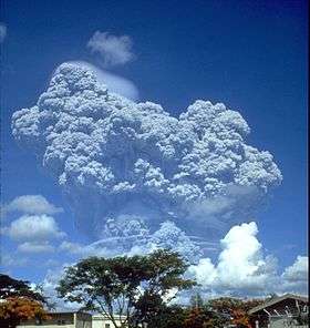
The second-largest volcanic eruption of the 20th century, and by far the largest eruption to affect a densely populated area, occurred at Mount Pinatubo on June 15, 1991. The eruption produced high-speed avalanches of hot ash and gas, giant mudflows, and a cloud of volcanic ash hundreds of miles across.[23]
Climactic eruption buildup
In early June, tiltmeter measurements had shown that the volcano was inflating, evidently due to growing amounts of magma filling the reservoir beneath the summit. At the same time, seismic activity, previously concentrated at a depth of a few kilometers below a point about 5 kilometres (3.1 mi) northwest of the summit, shifted to shallow depths just below the summit.
On June 7, the first magmatic eruptions took place with the formation of a lava dome at the summit of the volcano. The dome grew substantially over the next five days, reaching a maximum diameter of about 200 m (660 ft) and a height of 40 m (130 ft).
Timely forecasts of an eruption by scientists from the Philippine Institute of Volcanology and Seismology and the U.S. Geological Survey enabled people living near the volcano to evacuate to safer distances, saving at least 5,000 lives.
A small explosion at 03:41 on June 12 marked the beginning of a new, more violent phase of the eruption.
A few hours later the same day, large explosions lasting about half an hour generated an eruption column which quickly reached heights of over 19 kilometres (12 mi), and which generated large pyroclastic flows extending up to 4 km (2.5 mi) from the summit in some river valleys. Fourteen hours later, a 15-minute eruption hurled ash to heights of 24 km (15 mi). Friction in the uprushing ash column generated abundant lightning.
A third large eruption began at 08:41 on June 13, after an intense swarm of small earthquakes over the previous two hours. It lasted about five minutes, and the eruption column once again reached 24 km. After three hours of quiet, seismic activity began, growing more and more intense over the next 24 hours, until a three-minute eruption generated a 21 km (13 mi) high eruption column at 13:09 on June 14.
Tephra fall from these four large eruptions was extensive to the southwest of the volcano. Two hours after the last of these four explosions, a series of eruptions began which lasted for the next 24 hours, and which saw the production of much larger pyroclastic flows and surges which traveled several kilometers down river valleys on the flanks of the volcano.
Dacite was the igneous rock making up the tephra in these eruptions and in the following climactic event. The most abundant phenocryst minerals were hornblende and plagioclase, but an unusual phenocryst mineral was also present—the calcium sulfate, anhydrite. The dacite magma was more oxidized than most magmas, and the sulfur-rich nature of the eruption was probably causally related to the redox state.
The climactic eruption
The June 15 final massive eruption of Mount Pinatubo began at 13:42. It caused numerous large earthquakes due to the collapse of the summit of Mount Pinatubo and the creation of a caldera 2.5 kilometers (1.5 miles) in diameter, reducing the peak from 1745 meters (5725 feet) to 1485 meters (4872 feet).[25]
All the seismographs at Clark Air Base had been rendered completely inoperative by 14:30 mostly by super-massive pyroclastic surges. Intense atmospheric pressure variation was also recorded.
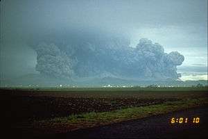
On the same day, Typhoon Yunya, locally named as Diding, struck the island, with its center passing about 75 km (47 mi) north of the volcano. The typhoon rains mostly obscured the eruption, but measurements showed that ash was ejected to 34 km (21 mi) high by the most violent phase of the eruption, which lasted about three hours. Pyroclastic flows poured from the summit, reaching as far as 16 km (9.9 mi) away from it. Typhoon rains mixed with the ash deposits caused massive lahars.
The ash cloud from the volcano covered an area of some 125,000 km2 (48,000 sq mi), bringing total darkness to much of central Luzon. Almost all of the island received some ash fall, which formed a heavy, rain-saturated snow-like blanket. Tephra fell over most of the South China Sea and ashfall was recorded as far away as Vietnam, Cambodia and Malaysia.
Twelve days after the first magmatic eruptions of June 3, on June 15, 1991, by about 22:30, and about nine hours after the onset of the most recent climactic phase, atmospheric pressure waves had decreased to the pre-eruption levels. No seismic records were available at this time, but volcanologists believe 22:30 marked the end of the climactic eruption.
Vast quantities of minerals and metals were brought to the surface. Overall, introduced to the surface environment, was an estimated 800,000 t (880,000 short tons) of zinc, 600,000 t (660,000 short tons) of copper, 550,000 t (610,000 short tons) of chromium, 300,000 t (330,000 short tons) of nickel, and massive amounts of toxic heavy metals such as 100,000 t (110,000 short tons) of lead, 10,000 t (11,000 short tons) of arsenic, 1,000 t (1,100 short tons) of cadmium, and 800 t (880 short tons) of mercury.[26]
The eruption effects on aircraft
At least 16 commercial aircraft made damaging in-flight encounters with the ash cloud ejected by the June 15 eruption, as did other aircraft on the ground. The encounters caused loss of power to one engine on each of two aircraft. 10 engines were damaged and replaced, including all four engines of one jumbo jet. Longer term damage to aircraft and engines was reported, including accumulation of sulfate deposits on engines.[27] The eruption also irreparably damaged the Philippine Air Force's recently retired fleet of Vought F-8s, as these were in open storage at Basa Air Base at the time.[28]
Aftermath of the 1991 eruption

Explosivity of the eruption
The June 15 eruption had a volcanic explosivity index (VEI) of 6, and came some 450–500 years after the volcano's last known eruptive activity. The eruption ejected about 10 km3 (2.4 cu mi) of material, making it the largest eruption since that of Novarupta in 1912 and some ten times larger than the 1980 eruption of Mount St. Helens. Ejected material such as tephra fallout and pyroclastic flow deposits are much less dense than magma, and the volume of ejected material was equivalent to about 4 km3 (0.96 cu mi) of unerupted material.[29]
The former summit of the volcano was obliterated and replaced by a caldera 2.5 km (1.6 mi) wide. The highest point on the caldera rim now stood 1,485 m (4,872 ft) above sea level, some 260 m (850 ft) lower than the pre-eruption summit.
Death toll
A reported 847 people were killed by the eruption, mostly by roofs collapsing under the weight of accumulated wet ash, a hazard amplified by the simultaneous arrival of Typhoon Yunya.[30][31] The evacuation in the days before the eruption certainly saved tens of thousands of lives, and has been hailed as a great success for volcanology and eruption prediction.
After the eruption, about 500,000 people continue to live within 40 km (25 mi) of the mountain, with population centers including the 150,000 in Angeles City and 30,000 at Clark Freeport Zone.
Effects on agriculture
Many reforestation projects were destroyed in the eruption, with a total area of 150 km2 (37,000 acres) valued at 125 million pesos destroyed. Agriculture was heavily disrupted, with 800 km2 (200,000 acres) of rice-growing farmland destroyed, and almost 800,000 head of livestock and poultry killed, destroying the livelihoods of thousands of farmers. The cost to agriculture of eruption effects was estimated to be 1.5 billion pesos.
Many farmers near Pinatubo began growing crops such as peanuts, cassava and sweet potatoes, which are quick-ripening and could be harvested before the threat of lahar flows during the late summer rainy season.[32]

Local economic and social effects
In total, 364 communities and 2.1 million people were affected by the eruption, with livelihoods and houses being damaged or destroyed. More than 8,000 houses were completely destroyed, and a further 73,000 were damaged. In addition to the severe damage sustained by these communities, roads and communications were damaged or destroyed by pyroclastic flows and lahar throughout the areas surrounding the volcanoes. Total losses in 1991 and 1992 alone were estimated at 10.6 and 1.2 billion pesos respectively, including damage to public infrastructure estimated at 3.8 billion pesos (~US$92,000,000). Education for thousands of children was seriously disrupted by the destruction of schools in the eruption.[33]
The eruption of Pinatubo severely hampered the economic development of the surrounding areas. The gross regional domestic product of the Pinatubo area accounted for about 10% of the total Philippine gross domestic product. The GRDP had been growing at 5% annually before the eruption, but fell by more than 3% from 1990 to 1991. In 1991, damage to crops and property was estimated at $374 million, to which continuing lahar flows added a further $69 million in 1992. 42 percent of the cropland around the volcano was affected by mudflows, dealing a severe blow to the agricultural economy in the region.[34]
Lahars

Since the eruption, each heavy rain brought lahars from the mountain range, displacing thousands of people and inflicting extensive damage to buildings and infrastructure costing billions to repair. A large supply of funds were spent in constructing dikes and dams to control the post-eruption lahar flows.[32]
Several important river systems stem from Mount Pinatubo, the major rivers being the Abacan, Tarlac, Pasig-Potrero, Sta. Lucia, Bucao, Santo Tomas, Maloma, Tanguay, Ashley, and Kileng rivers. Before the eruption, these river systems were important ecosystems, but the eruption filled many valleys with deep pyroclastic deposits. Since 1991, the rivers have been clogged with sediment, and the valleys have seen frequent lahars which continued for years after the eruption. Studies show that the river systems will take years to recover from the 1991 eruption.
On September 3, 1995 a lahar buried San Guillermo Parish Church to half its 12-meter height.[32]
Military impact
The United States Air Force initiated a massive airlift effort to evacuate American service members and their families from the two affected bases during and immediately following the eruption, named Operation Fiery Vigil. Most personnel were initially relocated to Guam, Okinawa, and Hawaii, although some returned to the continental United States. Clark Air Base was ultimately abandoned by the United States military, and Subic Bay reverted to Philippine control the next year following the breakdown of lease negotiations.
Global environmental effects
The powerful eruption of such an enormous volume of lava and ash injected significant quantities of aerosols and dust into the stratosphere. Sulfur dioxide oxidized in the atmosphere to produce a haze of sulfuric acid droplets, which gradually spread throughout the stratosphere over the year following the eruption. The injection of aerosols into the stratosphere is thought to have been the largest since the eruption of Krakatoa in 1883, with a total mass of SO
2 of about 17,000,000 t (19,000,000 short tons) being injected—the largest volume ever recorded by modern instruments (see chart and figure).
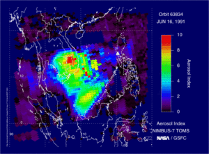
This very large stratospheric injection resulted in a reduction in the normal amount of sunlight reaching the Earth's surface by roughly 10% (see figure). This led to a decrease in northern hemisphere average temperatures of 0.5–0.6 °C (0.9–1.1 °F) and a global fall of about 0.4 °C (0.7 °F).[9][35] At the same time, the temperature in the stratosphere rose to several degrees higher than normal, due to absorption of radiation by the aerosol. The stratospheric cloud from the eruption persisted in the atmosphere for three years after the eruption. While not directly responsible, the eruption may have played a part in the formation of the 1993 Storm of the Century.[36]
The eruption had a significant effect on ozone levels in the atmosphere, causing a large increase in the destruction rate of ozone. Ozone levels at mid-latitudes reached their lowest recorded levels, while in the southern hemisphere winter of 1992, the ozone hole over Antarctica reached its largest ever size until then, with the fastest recorded ozone depletion rates. The eruption of Mount Hudson in Chile in August 1991 also contributed to southern hemisphere ozone destruction, with measurements showing a sharp decrease in ozone levels at the tropopause when the aerosol clouds from Pinatubo and Hudson arrived.
Impact on the indigenous people of Pinatubo
The Aeta people were the hardest hit by the eruption. After the areas surrounding the volcano were declared safe, many Aetas returned to their old villages only to find them destroyed by pyroclastic and lahar deposits. Some were able to return to their former way of life, but most moved instead to government-organized resettlement areas. Conditions on these were poor, with each family receiving only small plots of land not ideal for growing crops. Many Aeta found casual labor working for lowland farmers, and overall Aeta society became much more fragmented, and reliant on and integrated with lowland culture.[37]
Aftermath of the eruptions in pictures
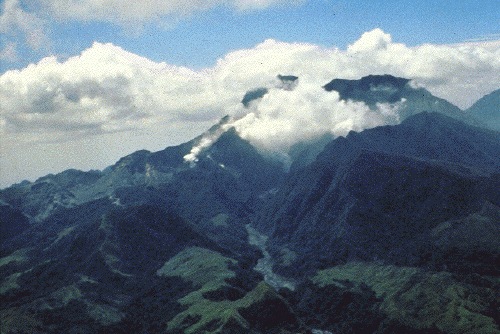
 Explosive eruption, late June 1991
 Snow-like ashfall caused by heavy rain mixing with ash columns
 Erosional dissection of ash deposits on Pinatubo
 Aircraft hangars at Clark Air Base destroyed by ashfall
 Lahars from Pinatubo volcano fill the broad Santo Tomás River valley SW of the volcano
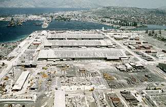
 A McDonnell-Douglas DC-10 owned by World Airways rests on its tail due to heavy ashfall deposited by the eruption at Cubi Point Naval Air Station
Activity since 1991

Following the climactic eruption of June 15, 1991, activity at the volcano continued at a much lower level, with continuous ash eruptions lasting until August 1991 and episodic eruptions continuing for another month. Activity then remained low until July 1992 when a new lava dome started growing in the caldera. Volcanologists suspected that further violent eruptions could be possible, and some areas were evacuated. However, the eruption was only minor; and since that episode, the volcano has been quiet.
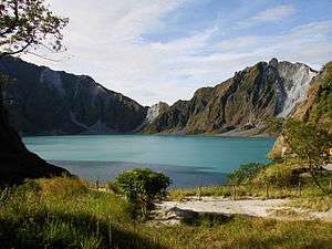
Lake Pinatubo
The 1991 caldera afterwards filled with water from monsoon rains and a crater lake, Lake Pinatubo, was formed. In 1992, a growing lava dome formed an island, which was eventually submerged by the lake. Initially, the lake was hot and highly acidic, with a minimum pH of 2 and a temperature of about 40 °C (104 °F). Subsequent rainfall cooled and diluted the lake, lowering the temperature to 26 °C (79 °F) and raising the pH to 5.5 by 2003.
The lake deepened by about 1 m (3.3 ft) per month on average, eventually submerging the lava dome, until September 2001, when fears that the walls of the crater might be unstable prompted the Philippine government to order a controlled draining of the lake. An estimated 9,000 people were once again evacuated from surrounding areas in case a large flood was accidentally triggered. Workers cut a 5 m (16 ft) notch in the crater rim and drained about a quarter of the lake's volume.[38]

Recent activity
On 10 July 2002 the west wall of the crater collapsed, slowly releasing approximately 160 million cubic meters of water and sediments into the Maraunot River in Botolan, Zambales.[39]
On 26 July 2011, a 5.9 magnitude earthquake struck close to Pinatubo; however, no major damages or casualties were reported.[40]
Cultural history
The word pinatubo could mean "fertile place where one can make crops grow", or could mean "made to grow", in Tagalog and Sambal, which may suggest a knowledge of its previous eruption in about 1500 AD. There is a local oral tradition suggestive of a folk memory of earlier large eruptions. An ancient legend tells of Bacobaco, a terrible spirit of the sea, who could metamorphose into a huge turtle and throw fire from his mouth. In the legend, when being chased by the spirit hunters, Bacobaco flees to the mountain and digs a great hole in its summit showering the surrounding land with rock, mud, dust and fire for three days; howling so loudly that the earth shakes.[41]
History among Aetas
Aeta elders tell many stories about the history of the mountain, the best known being that it was once a Batung Mabye (Kapampangan language for "living stone"). It was said to have been planted on a kingdom by a displeased sorcerer but relocated by a hero. The mountain was soon turned into the abode of Apo Namalyari ("The lord of happenings/events"), the pagan deity of the Sambal, Aeta, and Kapampangans living on the Zambales range.[42]
It was said to comprise the whole mountain range until Sinukuan of Mount Arayat (the god of the Kapampangans) became a strong rival of Namalyari. Their fight, which took place over the center plains, shattered the mountain into smaller bodies and Mount Arayat lost its center peak. Other versions have it that Pinatubo's peak shattered because of Namalyari's immense fury in an attempt to teach humans the meaning of fear and show how misdeeds will be punished.[42]
According to the elders, Apo Namalyari caused the 1991 eruption because of displeasure toward illegal loggers and Philippine National Oil Company executives who performed deep exploratory drilling and well testing on the mountain looking for geothermal heat from 1988 to 1990.[43] Discouraging results from the wells forced the abandonment of the prospect 13 months before the April 2, 1991 explosions.[44]
Aetas granted ownership of Pinatubo
After being driven away by the 1991 eruption of Mount Pinatubo, in May 2009 some 454 Aeta families in Pampanga were given the first clean ancestral land ownership on Mount Pinatubo with the Certificate of Ancestral Domain Title (CADT) by the National Commission on Indigenous Peoples (NCIP), the government agency that deals with issues concerning indigenous people of the Philippines. The approved and declared net land area of 7,440.1 ha (18,385 acres) covers the barangays of Mawakat and Nabuklod in Floridablanca, Pampanga, plus a portion of San Marcelino, Zambales, and a portion of Barangay Batiawan in Subic, Zambales.[45]
On January 14, 2010, some 7,000 Aeta families from Zambales were officially granted the Certificate of Ancestral Domain Title (CADT) covering the Zambales side of Pinatubo which includes the summit and Lake Pinatubo, officially becoming their lutan tua (ancestral land). The ancestral domain title covers 15,984 ha (39,500 acres) and includes the villages of Burgos, Villar, Moraza and Belbel in Botolan and portions of the towns of Cabangan, San Felipe and San Marcelino.[46][47]
Having the land title will protect them from others — including foreigners — exploiting their land without compensation to the indigenous tribes. In the past, the Aetas had to contend with mining companies, loggers, and, recently, tourist companies who earn from Mount Pinatubo but do not compensate the local tribes.[47]
Ancestral domain titles are awarded to a certain community or indigenous group who have occupied or possessed the land continuously in accordance with their customs and traditions since time immemorial. They have the legal right to collectively possess and to enjoy the land and its natural resources to the exclusion of others.[47]
Pinatubo in popular culture
Long before Mt. Pinatubo became famous for its cataclysmic eruption, Philippine President Ramon Magsaysay, a native of Zambales, named his C-47 presidential plane "Mt. Pinatubo". The plane crashed in Mount Manunggal in Cebu province in 1957, killing the President and 24 others on board.[48] Mt. Pinatubo is also featured in the Filipino romantic comedy film Crazy Beautiful You in which Kiko and Jackie go on a trip to the lake.


Hiking Pinatubo
The caldera formed and Lake Pinatubo has since become a tourist attraction with the preferred route through Barangay Santa Juliana in Capas, Tarlac.[49]
See also
- List of active volcanoes in the Philippines
- List of inactive volcanoes in the Philippines
- List of volcanic eruptions by death toll
- List of potentially active volcanoes in the Philippines
- Timeline of volcanism on Earth
Notes
- ↑ "Pinatubo Volcano". The Philippine Institute of Volcanology and Seismology (PHIVOLCS).
- ↑ Pinatubo, Global Volcanism Program.
- ↑ Mount Pinatubo Eruption - Mount Pinatubo
- ↑ "Tarlac map". University of Texas in Austin Library. Retrieved 2011-08-02.
- ↑ "Report of the Philippine Commission to the President, 1901 Vol. III", pg. 141. Government Printing Office, Washington, 1901.
- 1 2 "The Cataclysmic 1991 Eruption of Mount Pinatubo, Philippines". Retrieved 2007-04-09.
- ↑ Rodolfo, Umbal, and Alonso. "Two Years of Lahars on the Western Flank of Mount Pinatubo: Initiation, Flow Processes, Deposits, and Attendant Geomorphic and Hydraulic Changes". USGS Publications. Retrieved 2012-03-07.
- ↑ Stephen Self; Jing-Xia Zhao; Rick E. Holasek; Ronnie C. Torres & Alan J. King (1999). "The Atmospheric Impact of the 1991 Mount Pinatubo Eruption". Retrieved July 25, 2014.
- 1 2 "Mt. Pinatubo's cloud shades global climate". Science News. Retrieved 2010-03-07.
- ↑ Tactical Pilotage Chart, Sheet K-11B, Defense Mapping Agency, Department of Defense, 1982.
- ↑ Philippine Census
- ↑ Pinatubo, Philippines
- ↑ Central Luzon Mountaineer
- ↑ U.S. War Department. "Report of the Philippine Commission, 1901 Vol. III"), pg. 141. Government Printing Office, Washington.
- ↑ Topinka, Lyn (July 13, 2009). "Description: Mount Pinatubo, Philippines". United States Geological Survey. Retrieved April 18, 2010.
- 1 2 3 4 5 6 7 8 Newhall, Christopher G.; Punongbayan, Raymundo S., eds. (1996). "Eruptive history of Mount Pinatubo". FIRE and MUD: Eruptions and Lahars of Mount Pinatubo, Philippines. Philippine Institute of Volcanology and Seismology; University of Washington Press. ISBN 0-295-97585-7.
- ↑ Delfin, F.G.; Villarosa, H.G.; and Layugan, D.B. "Geothermal Exploration of the pre-1001 Mount Pinatubo Hydrothermal System". United States Geological Survey Publications. Retrieved 2012-03-07.
- ↑ Photographic Record, Mount Pinatubo
- ↑ http://pubs.usgs.gov/pinatubo/punong1/fig2a.jpg
- ↑ USGS. "Earthquake Information for 1990". Retrieved 2010-03-06.
- ↑ USGS Earthquake Magnitude Policy
- ↑ Factoran, Fulgencio Jr. S. (2001). "The July 16 Luzon Earthquake: A Technical Monograph". Inter-Agency Committee for Documenting and Establishing Database on the July 1990 Earthquake. Philippine Institute of Volcanology and Seismology. Archived from the original on 2008-09-07. Retrieved 2009-01-07.
- 1 2 "The Cataclysmic 1991 Eruption of Mount Pinatubo, Philippines". U.S. Geological Survey Fact Sheet 113-97. U.S. Geologic Survey. 1997.
- ↑ Rosenberg, Matt. "Mount Pinatubo Eruption - The Volcanic Mount Pinatubo Eruption of 1991 that Cooled the Planet".
- ↑ Mount Pinatubo Eruption _ By Matt Rosenberg Geography Expert. http://geography.about.com/od/globalproblemsandissues/a/pinatubo.htm
- ↑ Garret, R.G. (November 2000). "Natural sources of metals in the environment". Human and Ecological Risk Assessment: an International Journal. 6 (6): 945–963. doi:10.1080/10807030091124383.
- ↑ In 1991, it was Pinatubo - INQUIRER.net, Philippine News for Filipinos
- ↑ Philippine Air Force. "Philippine Air Force: F-8 Crusader". Philippine Air Force. Archived from the original on 2007-06-25. Retrieved 10 November 2013.
- ↑ "Mt. Pinatubo, Luzon, Philippines". National Geophysical Data Center (U.S. NOAA). Retrieved 2007-12-02.
- ↑ CoolGeography - Mount Pinatubo
- ↑ "Ashfall, Pyroclastic Flow, Lahar: The Aftermath". Pinatubu Volcano: The Sleeping Giant Awakens. expo.edu.ph. Archived from the original on 2011-07-26.
- 1 2 3 Reilly 2009, p. 70.
- ↑ Joan Martí; Gerald Ernst (2005). Volcanoes and the environment. Cambridge University Press. pp. 450. ISBN 978-0-521-59254-3.
- ↑ Reilly 2009, p. 69.
- ↑ Ward, Peter L. (2 April 2009). "Sulfur Dioxide Initiates Global Climate Change in Four Ways" (PDF). Thin Solid Films. 517 (11): 3188–3203. Bibcode:2009TSF...517.3188W. doi:10.1016/j.tsf.2009.01.005. Retrieved 2010-03-19.
- ↑ Stevens, William (March 14, 1993). "THE BLIZZARD OF '93: Meteorology; 3 Disturbances Became a Big Storm". The New York Times. Retrieved July 29, 2014.
- ↑ Shimizu, Hiromu (2002), Struggling for Existence after the Pinatubo Eruption 1991: Catastrophe, Suffering and Rebirth of Ayta Communities. Paper presented inter-congress of the International Union of Anthropological and Ethnological Sciences, Tokyo, Japan. Retrieved from the original on 2004-08-15.
- ↑ "Filipinos return as volcano lake drains". BBC News. September 7, 2001.
- ↑ Timelines Page @ glassiris.info
- ↑ Gonzaga, Robert and Orejas, Tonette (2011-07-26). "5.9-magnitude quake jolts households in Luzon, Metro areas". Inquirer News.
- ↑ Rodolfo, K.S. & Umbal, J.V. (2008) "A prehistoric lahar-dammed lake and eruption of Mount Pinatubo described in a Philippine aborigine legend", J. Volcanol. Geotherm. Res., 176, 432-437
- 1 2
- ↑ Loeb, Vernon (1991-07-21). "Natives Who Worship Pinatubo Feel Its Wrath". Seattle Times. Retrieved 2008-11-22.
- ↑ Delfin Jr., F.G., Villarosa, H.G.. "Geothermal Exploration of the pre-1991 Mount Pinatubo Hydrothermal System". USGS. Retrieved on 2011-08-14.
- ↑ (2009-05-27). "Aetas in Pampanga awarded first clean title of ancestral domain". Scribd. Retrieved on 2011-08-14.
- ↑ Orejas, Tonette (2009-11-27). "It’s official: Pinatubo is now owned by Aetas". PIPLinks (originally from Philippine Daily Inquirer). Retrieved on 2011-08-14.
- 1 2 3 Valdez, Katrina Mennen A. (2010-01-14). "Aetas to receive title to domain at Mt. Pinatubo". Preda Foundation. Retrieved on 2011-08-14.
- ↑ Dominico C. Moneva (2006-03-18). "Speak out: Magsaysay's death". Sun Star Cebu. Archived from the original on 2008-05-17. Retrieved 2008-03-21.
- ↑ "Trekking-Mt-Pinatubo". inquirer.net. 2010-05-29. Retrieved 13 June 2012.
References
- Chakraborty P, et al. (2009). "Volcanic mesocyclones" (PDF). Nature. 458: 495–500. Bibcode:2009Natur.458..497C. doi:10.1038/nature07866.
- Decker, R. and Decker, B. (1997) Volcanoes, 3rd edition, WH Freeman, New York.
- McCormick, M. Patrick; et al. (1995). "Atmospheric effects of the Mt Pinatubo eruption". Nature. 373 (6513): 399–404. Bibcode:1995Natur.373..399M. doi:10.1038/373399a0.
- Rantucci, Giovanni (1994). Geological Disasters In The Philippines: The July 1990 Earthquake And The June 1991 Eruption of Mount Pinatubo. Description, effects and lessons learned. Philippine Institute of Volcanology and Seismology (PHIVOLCS). ISBN 978-0-7881-2075-6. Retrieved 2009-08-15.
- Reilly, Benjamin (2009). Disaster and human history: case studies in nature, society and catastrophe. McFarland. ISBN 978-0-7864-3655-2.
- Self S.; Zhao, Jing-Xia; Holasek, R.E.; Torres, R.C.; King, A.J. (1998). Newhall, C.G., Punongbayan, R.S., eds. "Fire and Mud, Eruptions and Lahars of Mount Pinatubo, Philippines". Washington: Smithsonian Institution - Global Volcanism Program: 1126. Retrieved 2010-04-21.
The atmospheric impact of the 1991 Mount Pinatubo eruption
- Scaillet, B. and Evans, B. W. (1999) The June 15, 1991 Eruption of Mount Pinatubo. I. Phase Equilibria and Pre-eruption P–T–fO2–fH2O Conditions of the Dacite Magma. Journal of Petrology, v. 40, 381–411.
- Stimac J.A., Goff F., Counce D., Larocque A.C.L., Hilton D.R. (2003), The crater lake and hydrothermal system of Mount Pinatubo, Philippines: evolution in the decade after eruption, Bulletin of Volcanology, v. 66, p. 149–167
- Wiesner, M.G., Wetzel, A. Catane, S.G., Listanco, E.L. and Mirabueno, H.T. (2004) Grain size, areal thickness distribution and controls on sedimentation of the 1991 Mount Pinatubo tephra layer in the South China Sea. Bulletin of Volcanology, v. 66, 226–242.
- Dhot, S. Mt Pinatubo Safety.
External links
| Wikimedia Commons has media related to Mount Pinatubo. |

- Mount Pinatubo Mount Pinatubo page
- Fire and Mud. Eruptions and Lahars of Mount Pinatubo, United States Geological Survey site
- Weather effects of the 1991 eruption EOS Volcanology.
- The Cataclysmic 1991 Eruption of Mount Pinatubo, Philippines. United States Geological Survey site
- Pinatubo, Philippines (volcanic images)