Mow Cop

Coordinates: 53°06′47″N 2°13′03″W / 53.112973°N 2.217582°W
Mow Cop /ˈmaʊˈkɒp/ is an isolated village which straddles the Cheshire–Staffordshire border, and is divided between the North West and West Midlands regions of England. It is 24 miles south of Manchester and 6 miles north of Stoke-on-Trent, lying on a steep hill of the same name rising up to 335m (1099ft) above sea level.[1] The village fringes the Cheshire Plain to the west and the hills of the Staffordshire Moorlands to the east. For population details taken at the 2011 census see Kidsgrove.
The name is first recorded as "Mowel" around 1270 AD, and is believed to be derived from either the Anglo-Saxon Mūga-hyll, meaning "heap-hill", with copp = "head" added later, or the Common Celtic ancestor of Welsh moel (= hill), with Anglo-Saxon copp added later.[2]
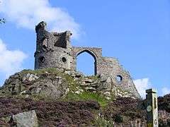
At the village's summit, men once quarried stone to make into querns, used since the Iron Age for milling corn; this trade ended during the Victorian period. The village also has a long history of coal mining. A 65 ft rock feature called the Old Man O'Mow sits in one of the quarry areas and is believed to be the site of an ancient cairn. The most dominant feature is Mow Cop Castle which is a folly of a ruined castle at the summit of the hill, built in 1754. Both Mow Cop and Old Man O'Mow are under the management of the National Trust and sit on the walking route of the Cheshire Gritstone Trail. The village was served by a railway station which was opened by the North Staffordshire Railway on 9 October 1848.
Mow Cop is also noteworthy as the birthplace of the Primitive Methodist movement. Starting in 1800, Hugh Bourne from Stoke-on-Trent and William Clowes from Burslem began holding open-air prayer meetings. On 31 May 1807, a large 14-hour camp meeting was held, leading to development of the Primitive Methodist Church in 1810. These camp meetings became a regular feature at Mow Cop, with camps held to celebrate the 100th, 150th and 200th anniversaries of the first camp.[3]
Since the late 20th century, Mow Cop is known for its Killer Mile, a one-mile road race from the railway level crossing on the western side of the hill, up to the castle. The race was first organized in the early 1980s by John Britton.[4] The climb is also well known among local cyclists and features in the 100 Greatest Cycling Climbs in Britain.[5]
Geography
The 335m (1099ft) hill in which the village lies upon is a moorland ridge composed of Sandstone and Millstone Grit rising eastwards above the Cheshire Plain. It lies at the western edge of the Staffordshire Moorlands, forming an upland fringe of the southern Pennines, most of which are inside the Peak District National Park lying further east.[6] On a clear day, the hill offers views extending to the West Pennine Moors, Welsh mountains (including Snowdonia), Shropshire Hills and Cannock Chase.
Representation in other media
- The village is featured prominently in the 1973 novel, Red Shift, by Alan Garner.
Notable residents
- Alan Jones, former Port Vale Football Club Director
- Jack Simcock (born 6 June 1929; died 13 May 2012), artist
External links
| Wikimedia Commons has media related to Mow Cop. |
- Mow Cop Computer-generated summit panoramas
- www.mowcoprunner.com
- History of Mow Cop
- Photographs of the castle
- Campsite on Mow cop
References
- ↑ "Mow Cop - Trig Point". Hill Bagging. Retrieved 29 April 2016.
- ↑ Kent, Jeff (2013). Staffordshire's 1,000-Foot Peaks. Witan Books. ISBN 978-0-9927505-0-3.
- ↑ Farndale, W. E. (1950). The Secret of Mow Cop: A New Appraisal of the Origins of Primitive Methodism. London: Epworth Press.
- ↑ "Killer Mile". www.mowcop.info. Mow Cop Residents Association. Retrieved 30 June 2015.
- ↑ Warren, Simon (2010). 100 greatest cycling climbs: A road cyclist's guide to Britain's hills. London: Frances Lincoln. ISBN 9780711231207.
- ↑ "Potteries and Churnet Valley". Scottish Natural Heritage. Retrieved 3 May 2016.
Cheshire Portal | |
| Unitary authorities | |
| Major settlements | |
| Rivers | |
| Topics | |
| Unitary authorities | |
|---|---|
| Boroughs or districts | |
| Major settlements | |
| Rivers | |
| Canals | |
| Topics | |