Mountain View, California
| City of Mountain View | ||
|---|---|---|
| Charter city[1] | ||
|
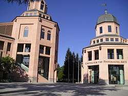
City Hall and the Center for the Performing Arts in the Downtown area | ||
| ||
 Location of Mountain View within Santa Clara County, California | ||
 City of Mountain View Location in the United States | ||
| Coordinates: 37°23′22″N 122°4′55″W / 37.38944°N 122.08194°WCoordinates: 37°23′22″N 122°4′55″W / 37.38944°N 122.08194°W | ||
| Country | United States | |
| State | California | |
| County | Santa Clara | |
| Incorporated | November 7, 1902[2] | |
| Government | ||
| • Type | Council-manager[3] | |
| • Mayor | Pat Showalter[3] | |
| • Vice mayor | Ken Rosenberg[3] | |
| • City Manager | Dan Rich[4] | |
| Area[5] | ||
| • Total | 12.273 sq mi (31.788 km2) | |
| • Land | 11.995 sq mi (31.068 km2) | |
| • Water | 0.278 sq mi (0.720 km2) 2.26% | |
| Elevation[6] | 105 ft (32 m) | |
| Population (April 1, 2010)[7] | ||
| • Total | 74,066 | |
| • Estimate (2013)[7] | 77,846 | |
| • Density | 6,000/sq mi (2,300/km2) | |
| Time zone | Pacific (UTC−8) | |
| • Summer (DST) | PDT (UTC−7) | |
| ZIP codes[8] | 94035, 94039–94043 | |
| Area code | 650 | |
| FIPS code | 06-49670 | |
| GNIS feature IDs | 277611, 2411186 | |
| Website |
www | |
Mountain View is a city located in Santa Clara County, California, United States, named for its views of the Santa Cruz Mountains.[9] From its origins as a stagecoach stop, it grew to a large suburb with a pedestrian-friendly downtown, free wi-fi, and a population of 74,066. The city borders Palo Alto and the San Francisco Bay to the north, Los Altos to the south, and Moffett Federal Airfield and Sunnyvale to the east.
Situated in the southern end of the San Francisco Peninsula in the San Francisco Bay Area, Mountain View is home to many high technology companies. In 1956, Shockley Semiconductor Laboratory, the first company to develop silicon semiconductor devices in what came to be known as Silicon Valley, was established in the city by William Shockley. Today, many of the largest technology companies in the world are headquartered in the city, including Google, Mozilla Foundation, Symantec, and Intuit. The original Byte Shop computer store was opened at 1063 El Camino Real, Mountain View by Paul Terrell, and the first 50 Apple I computers were sold from that location. The Santa Clara Valley Transportation Authority integrates the city with the neighboring cities of Palo Alto, Los Altos, and Sunnyvale.
History
The Mexican land grant of Rancho Pastoria de las Borregas was given in 1842 by Alta California Governor Juan Alvarado to Francisco Estrada. This grant was later passed on to Mariano Castro, who sold half of the land to Martin Murphy, Jr. Eventually, the former land grant became the cities of Mountain View and Sunnyvale.
First known as the major center of Fremont Twp. before the first California 1852 census, for Santa Clara County (online). [Fremont township is bounded on the north by San Mateo county and a portion of the bay of San Francisco; on the east by Alviso and Santa Clara townships; on the south by Redwood township, and on the west by San Mateo county.] Which meant that it was a predecessor to Mayfield and Palo Alto. Mountain View Station, officially named in 1864, had its beginnings earlier as a stagecoach stop on the route between San Francisco and San Jose, including the Butterfield Overland Mail. Incorporated on November 7, 1902. Phyllis Ave. & El Camino Real of today, was closer to what was once the original town center and its then San Jose Road. The early pioneers were commonly buried at the old cemetery between Mercy & Church, off Castro Street, now the present city Library and park, aka Pioneer Park. Reverend Henry Merrill Henderson, born in Maryland, age 35, arrived in Spring of 1852, with his family to meet with relatives Ricketts and many others from Missouri & Kentucky. He was the first Baptist minister in town and soon was going by horse to Half-Moon Bay, and McCartersville (Saratoga) for services. His next-door neighbor arrived later that year, Seligman Weilheimer and brother Samuel from Dossenheim, Baden, Germany, who built at that property, the first big general merchandise store in 1856. The Fremont twp. population was about 560 by 1860, less Mayfield Post office section, which began north of present San Antonio Road. The town's early growth was due to agriculture, William Bubb later being a town figure, buying 80 acres to farm in October 1851, where he died in 1864. His heirs expanded and intermarried in the area. Agriculture remained the primary industry into the middle of the 20th century. The U.S. Navy's adjacent 1000 acre Moffet Field Complex began after 1931 and brought many economic opportunities . After World War II, the population grew significantly with the development of the aerospace and electronics industries.[10] Between 1950 and 1960, the population grew from 6,563 to 30,889, an increase of 370.7%.
Today, high technology is the foundation of the local economy, and there exist few remnants of the city's agricultural past. In 1990, Kevin Duggan began his position as city manager. He built a relationship with Google, Inc., and issued a long-term lease to that and other technology companies. As of 2014, those leases generate over $5 million per year in city revenue. Duggan reinstituted a special tax district for the Shoreline area, which was a landfill and pig farm in 1990. That money allowed the city to create a large park and golf course on the site. The Castro Street downtown area also benefitted from a special tax district.[11]
Geography
According to the United States Census Bureau, the city has a total area of 12.3 sq mi (31.8 km2), of which 12.0 sq mi (31.1 km2) is land and 0.27 sq mi (0.7 km2) (2.26%) is water.
Mountain View is located at the north end of State Route 85, where it meets U.S. Route 101. State Route 82 follows the route of the historic El Camino Real through Mountain View. The city is bounded to the northwest by Palo Alto, to the north by the Bay, to the south and southwest by Los Altos, and to the east by Sunnyvale and Moffett Federal Airfield.
To the west lie the Santa Cruz Mountains, after which the city is named and which separate it from the Pacific Ocean. To the east lies the Diablo Range. Both ranges, which together form the boundaries of the Santa Clara Valley, are visible from many parts of the city.
Most of Mountain View consists of residential neighborhoods. Business parks are located mostly in the North Shoreline neighborhood, north of Highway 101, and east of Highway 85.
Climate
Mountain View has a warm-summer Mediterranean climate (Köppen climate classification Csb: dry-summer subtropical).[12] Summers are warm and dry, while winters are mild and wet. However, both summers and winters are somewhat moderated due to its relative proximity to the Pacific, although it has a lesser maritime influence than San Francisco further north on the peninsula.
| Climate data for Mountain View | |||||||||||||
|---|---|---|---|---|---|---|---|---|---|---|---|---|---|
| Month | Jan | Feb | Mar | Apr | May | Jun | Jul | Aug | Sep | Oct | Nov | Dec | Year |
| Record high °F (°C) | 75 (24) |
81 (27) |
82 (28) |
95 (35) |
102 (39) |
104 (40) |
104 (40) |
100 (38) |
104 (40) |
99 (37) |
86 (30) |
75 (24) |
104 (40) |
| Average high °F (°C) | 58.6 (14.8) |
61.9 (16.6) |
64.9 (18.3) |
68.7 (20.4) |
72.1 (22.3) |
76.3 (24.6) |
77.2 (25.1) |
77.4 (25.2) |
77.5 (25.3) |
73.4 (23.0) |
65.1 (18.4) |
58.8 (14.9) |
69.4 (20.8) |
| Daily mean °F (°C) | 50.7 (10.4) |
53.6 (12.0) |
56.1 (13.4) |
59 (15.0) |
62.8 (17.1) |
66.4 (19.1) |
68.2 (20.1) |
68.4 (20.2) |
67.6 (19.8) |
63.7 (17.6) |
56.1 (13.4) |
50.9 (10.5) |
60.3 (15.7) |
| Average low °F (°C) | 43 (6.1) |
45.3 (7.4) |
47.3 (8.5) |
49.5 (9.7) |
53.2 (11.8) |
56.7 (13.7) |
59.2 (15.1) |
59.2 (15.1) |
57.7 (14.3) |
53.8 (12.1) |
47.3 (8.5) |
43 (6.1) |
51.3 (10.7) |
| Record low °F (°C) | 21 (−6) |
27 (−3) |
30 (−1) |
32 (0) |
37 (3) |
43 (6) |
45 (7) |
46 (8) |
41 (5) |
32 (0) |
30 (−1) |
23 (−5) |
21 (−6) |
| Average precipitation inches (mm) | 2.799 (71.1) |
3.098 (78.7) |
2.299 (58.4) |
1 (25.4) |
0.5 (12.7) |
0.098 (2.5) |
0 (0) |
0 (0) |
0.201 (5.1) |
0.598 (15.2) |
1.598 (40.6) |
2.598 (66.0) |
14.701 (373.4) |
| Average precipitation days | 10 | 10.5 | 9.6 | 5.2 | 2.6 | 0.7 | 0.2 | 0.2 | 1.5 | 4.1 | 8.3 | 11.1 | 63.9 |
| Source: [13] | |||||||||||||
Economy
Mountain View is one of the major cities that make up Silicon Valley, and has many notable Silicon Valley companies either headquartered there or with a large presence.
Top employers
According to the City's 2015 Comprehensive Annual Financial Report,[14] the main employers in the city are:
| # | Employer | # of employees |
|---|---|---|
| 1 | 16,688 | |
| 2 | Symantec | 2,789 |
| 3 | Microsoft Powerpoint, MSN teams | 1,688 |
| 4 | El Camino Hospital | 1,300 |
| 5 | Intuit | 1,287 |
| 6 | 1,228 | |
| 7 | Samsung | 1,085 |
| 8 | Synopsys | 1,031 |
| 9 | Palo Alto Medical Foundation | 665 |
| 10 | City of Mountain View | 534 |
| 11 | Omnicell | 500 |
Economic past
Due to its history as a center for semiconductor manufacturing, Mountain View has seven sites on the Environmental Protection Agency's Final National Priorities List (NPL), a list of hazardous waste sites in the United States eligible for long-term remedial action financed under the federal Superfund program. The sites were formerly used by companies including Fairchild Semiconductor, Intel, Raytheon, Spectra-Physics, Jasco Chemical, GTE and Teledyne. These seven sites make up a portion of the 22 NPL sites in Santa Clara County, which are included in the total of 94 sites in California.[15]
Demographics
| Historical population | |||
|---|---|---|---|
| Census | Pop. | %± | |
| 1880 | 250 | — | |
| 1930 | 3,308 | — | |
| 1940 | 3,946 | 19.3% | |
| 1950 | 6,563 | 66.3% | |
| 1960 | 30,889 | 370.7% | |
| 1970 | 54,132 | 75.2% | |
| 1980 | 58,655 | 8.4% | |
| 1990 | 67,460 | 15.0% | |
| 2000 | 70,708 | 4.8% | |
| 2010 | 74,066 | 4.7% | |
| Est. 2015 | 80,435 | [16] | 8.6% |
2010
The 2010 United States Census[18] reported that Mountain View had a population of 74,066. The population density was 6,034.8 people per square mile (2,330.0/km²). The racial makeup of Mountain View was 56.0% (41,468) White, 26.0% (19,232) Asian, 2.2% (1,629) African American, 0.5% (391) Pacific Islander, 0.5% (344) Native American, 9.8% (7,241) from other races, and 5.1% (3,761) from two or more races. Non-Hispanic Whites numbered 32,638 (44.1%) while there were 16,071 Hispanic or Latino residents of any race (21.7% of the population).
The census reported that 73,801 people (99.6% of the population) lived in households, 145 (0.2%) lived in non-institutionalized group quarters, and 120 (0.2%) were institutionalized.
There were 31,957 households, out of which 8,731 (27.3%) had children under the age of 18 living in them, 13,806 (43.2%) were opposite-sex married couples living together, 2,456 (7.7%) had a female householder with no husband present, 1,253 (3.9%) had a male householder with no wife present. There were 1,928 (6.0%) unmarried opposite-sex partnerships, and 280 (0.9%) same-sex married couples or partnerships. 10,961 households (34.3%) were made up of individuals and 2,471 (7.7%) had someone living alone who was 65 years of age or older. The average household size was 2.31. There were 17,515 families (54.8% of all households); the average family size was 3.01.
The population was spread out with 14,594 people (19.7%) under the age of 18, 5,401 people (7.3%) aged 18 to 24, 28,577 people (38.6%) aged 25 to 44, 17,647 people (23.8%) aged 45 to 64, and 7,846 people (10.6%) who were 65 years of age or older. The median age was 35.9 years. For every 100 females there were 103.6 males. For every 100 females age 18 and over, there were 103.5 males.
There were 33,881 housing units at an average density of 2,760.6 per square mile (1,065.9/km²), of which 13,332 (41.7%) were owner-occupied, and 18,625 (58.3%) were occupied by renters. The homeowner vacancy rate was 1.3%; the rental vacancy rate was 4.4%. 32,002 people (43.2% of the population) lived in owner-occupied housing units and 41,799 people (56.4%) lived in rental housing units.
|
2000
As of the census[21] of 2000, there were 70,708 people, 31,242 households, and 15,902 families residing in the city. The population density was 2,263.7/km² (5,861.4/mi²). There were 32,432 housing units at an average density of 1,038.3/km² (2,688.5/mi²). The racial makeup of the city was 63.77% White, 20.67% Asian, 18.26% Hispanic or Latino (of any race), 2.53% African American, 0.39% Native American, 0.26% Pacific Islander, 8.32% from other races, and 4.07% from two or more races.
There were 31,242 households out of which 23.3% had children under the age of 18 living with them, 40.0% were married couples living together, 7.3% had a female householder with no husband present, and 49.1% were non-families. 35.6% of all households were made up of individuals and 7.0% had someone living alone who was 65 years of age or older. The average household size was 2.25 and the average family size was 2.97.
In the city the population was spread out with 18.0% under the age of 18, 8.3% from 18 to 24, 43.4% from 25 to 44, 19.8% from 45 to 64, and 10.5% who were 65 years of age or older. The median age was 35 years. For every 100 females there were 106.8 males. For every 100 females age 18 and over, there were 106.9 males.
According to a 2007 estimate the median income for a household in the city was $82,648, and the median income for a family was $105,079.[22] Males had a median income of $64,585 versus $44,358 for females. The per capita income for the city was $39,693. About 3.6% of families and 6.8% of the population were below the poverty line, including 7.2% of those under age 18 and 5.9% of those age 65 or over.
Government


Mountain View has a council-manager government system. An executive city manager is in charge of several departments, while the city council, supported by several boards, commissions, and committees, is the legislature responsible for the ordinances of the city code. The executive in turn enforces the code and promulgates administrative regulations to execute it. The city clerk and attorney perform supporting roles. The Community Development Department is the agency responsible for planning and zoning.[23]
State and federal representatives
In the state legislature, Mountain View is in the 13th Senate District, represented by Democrat Jerry Hill, and in the 24th Assembly District, represented by Democrat Marc Berman.[24]
In the United States House of Representatives, Mountain View is in California's 18th congressional district, represented by Democrat Anna Eshoo.[25]
Education
Mountain View is home to both public and private schools.
Public
The public elementary (Bubb, Castro, Huff, Landels, Mistral, Monta Loma, Stevenson, and Theuerkauf) and middle schools (Crittenden and Graham) are governed by the Mountain View-Whisman School District.[26] Springer Elementary, although located within the borders of Mountain View, is governed by the Los Altos School District. The public high schools are governed by the Mountain View-Los Altos Union High School District and consist of Alta Vista High School, Mountain View High School, and Los Altos High School.[27] Mountain View High and Los Altos High each contain approximately 50% Los Altos residents and 50% Mountain View residents. Some Mountain View residents attend Almond Elementary and Egan Junior High in the Los Altos School District.
Mountain View taxed a large portion of its most valuable commercial and industrial properties in the Shoreline Regional Park Community at very low relative levels, and until the creation of a joint-powers agreement (JPA) in 2006, none of those property taxes reached the local schools. After the creation of the JPA, the Shoreline Regional Park Community shared less than $1 million per year with the elementary and high school districts.[28][29]
A citizen-supported parcel tax, largely aimed at reducing class size, was recently renewed with an overwhelming positive vote.[30] The current ratio of students to full-time-equivalent teachers in the Mountain View public elementary schools is 20.4 to one.[31]
Private
Notable private schools in Mountain View include: Saint Francis High School, a Roman Catholic secondary school; German International School of Silicon Valley(GISSV), a PK-12 German-English bilingual international school; and Yew Chung International School of Silicon Valley, a PK-12 Chinese-English bilingual international school.
Library

Mountain View has one central public library, the Mountain View Public Library, offering video, music, books, self-check out, and access to the Internet. During the 2006-2007 fiscal year, 810,589 customers visited the Library. Circulation was more than 1.4 million, 105,870 reference and information questions were answered, 36,693 children listened to stories and participated in children's programs and 27,342 new books and media items were added to the collection which includes holdings of 300,000, including 210,000 books and 423 periodical subscriptions. The library also provides valuable outreach services through the bookmobile and S.O.S. volunteer program to those in Mountain View, who are unable to come to the main branch. The building was built in 1997. The second floor of the library has a special collection in a room devoted to the history of Mountain View, which features a portrait of Crisanto Castro, for whom the downtown main street is named. The library hosts the Mountain View Reads Together program.[32] Outside the library one can find a piece of the torn down Berlin Wall on display.[33]
Infrastructure
Transportation

.jpg)
The Downtown Mountain View Station is the transit center for the city, connecting the public commuter rail, light rail, bus, and private shuttle systems. Mountain View is served by the Caltrain commuter rail system, which runs from San Francisco to Gilroy. The two Caltrain stations in the city are Downtown Mountain View Station and San Antonio Station. The city is also served by the Santa Clara Valley Transportation Authority (VTA), which operates various bus lines and the light rail system. There are a total of four stations in the city on the Mountain View – Winchester VTA light rail line, with Downtown Mountain View Station serving as the northern terminus, while the other three stations are Whisman, Middlefield, and Bayshore/NASA. Many large local employers (including Google, Microsoft, Apple Inc., and NASA Ames Research Center) operate employee shuttles that stop at the Downtown Mountain View Station. There is also a free community shuttle bus that serves 50 stops within Mountain View.[34]
The nearest major airports are San Jose International Airport (SJC), San Francisco International Airport (SFO), and Oakland International Airport (OAK), in that order. Moffett Federal Airfield is located just north of Mountain View, but it is restricted to government, military, and private use. The nearest general aviation airport is the Palo Alto Airport of Santa Clara County.
Utilities
On August 16, 2006, after over a year of test deployments, Google announced that its implementation for free IEEE 802.11g wireless service for all of the City was fully operational.[35]
On February 19, 2014 the City of Mountain View and Google announced a new connectivity plan for residents to replace the existing system. Service will be available along the downtown corridor of Mountain View, primarily on Castro Street. Other areas to be covered include Rengstorff Park, the Mountain View Public Library, Senior, Community, and Teen Centers.[36]
Points of interest
Downtown

Mountain View has a pedestrian-friendly downtown centered on Castro Street. The downtown area consists of the seven blocks of Castro Street from the Downtown Mountain View Station transit center in the north to the intersection with El Camino Real in the south. The transit center links the Caltrain commuter rail and Santa Clara Valley Transportation Authority (VTA) light rail and bus systems.

Four blocks with a concentration of restaurants, cafes, and shops extend south from the downtown station. Chez TJ, one of the few restaurants rated by the Michelin Guide in the Bay Area, is located a block from Castro Street on Villa Street. Tied House, located next door, was one of the first brewpubs in the Bay Area, and is a popular stop in downtown.

The core of downtown is the plaza shared by City Hall, the Mountain View Center for the Performing Arts (MVCPA) and the Mountain View Public Library. The plaza is used for many community gatherings and events, and features a collection of public art. Peninsula Youth Theatre and TheatreWorks are among the home companies of the MVCPA.[37] The City Hall and MVCPA complex, designed by William Turnbull of San Francisco, opened in 1991.[38] Behind those buildings is Pioneer Park, formerly the site of Mountain View's first cemetery.[39]
The Mountain View Police Department is located two blocks away from Castro Street on Villa Street.
Since 1971, the city has held the annual Mountain View Art & Wine Festival on Castro Street by closing down the street to traffic for two days. There is a farmer's market in the Caltrain parking lot every Sunday morning. Every summer, once a month, the city celebrates Thursday Night Live by closing off Castro street to cars and providing live music events and car shows on Castro Street.
The entire length of El Camino in Mountain View is a low-density commercial area.
Parks

The largest park in the city is Shoreline Park, which was built on a landfill and runs along the Bay north of U.S. Route 101. It includes Shoreline Amphitheatre, Shoreline Golf Course, as well as Rengstorff House, which is listed in the National Register of Historic Places. On the north side, facing the Bay, the park includes tidal ponds and mudflats, accessible via pedestrian and bicycle paths. The San Francisco Bay Trail runs along Shoreline Park.
Stevens Creek runs through Mountain View from the south and empties into the Bay in Shoreline Park. A paved pedestrian and bicycle path, the Stevens Creek Trail, runs alongside the creek for nearly its entire distance in Mountain View.
Other parks include:
- Eagle Park, which holds a public swimming pool, dog-friendly lawn, and World War II war memorial
- Dana Park, a pocket park next to Mountain View Fire Station No. 1
- Charleston Park, a five-acre park located near the Googleplex. The park was designed by SWA Group who received an ASLA Centennial Medallion in 1999 for their work.[40]
-
 Media related to Parks of Mountain View, California at Wikimedia Commons
Other


- The Computer History Museum is home to the largest and most significant collection of computing artifacts in the world.
- Moffett Field is a joint civil-military federal airfield located between northern Mountain View and northern Sunnyvale, California. It is home to NASA Ames Research Center and the Air National Guard. Its hangars for blimps and rigid airships (now mostly vacant) make unique landmarks for motorists on Highway 101.
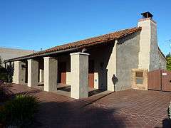
- The Historic Adobe Building, a small events center on Moffett Boulevard, is listed in the National Register of Historic Places.
- St. Joseph Parish was founded in 1905, and survived the 1906 San Francisco earthquake, only to burn down in 1928.[41] St. Joseph's Seminary operated here between 1924 and 1991.[42] The current St. Joseph church building was built in 1929.[41]
Sister cities
The Mountain View Sister City Affiliation was incorporated in 1974 as an independent non-profit governed by a Board of Directors. Mountain View is affiliated with the cities of
 Iwata, Shizuoka, Japan
.svg.png) Hasselt, Belgium
Hasselt, Belgium
The rock garden in Pioneer Park was a gift from the sister city of Iwata to celebrate the completion of Mountain View's City Hall building.[43] [44]
See also
Notable people
- Tully Banta-Cain, two-time Super Bowl champion[45]
- Carroll Clark, seven-time Academy Award for Best Art Direction nominee[46]
- Assaf Cohen, supporting actor, Heroes and Entourage[47]
- Gregor Collins, writer, actor, and producer[48]
- Brandon Crawford, professional baseball player in MLB, plays for the San Francisco Giants[49]
- Paula Creamer, professional golfer and formerly Women's World Golf Rankings number two player[50]
- Doris Gates, author and librarian[51]
- Dan Green, powerlifter, world record holder in 220 and 242 lbs weight classes[52]
- Steve Jobs, technology entrepreneur, co-founder and CEO of Apple[53]
- Salman Khan, online educator, resides in Mountain View[54]
- Mark Leonard former Left Fielder for the San Francisco Giants & Baltimore Orioles
- Sally J. Lieber former mayor of Mountain View and politician
- Kenny Roberts, Jr., 2000 500cc Road Racing World Champion[55]
- Jose Antonio Vargas, Pulitzer Prize winner and founder of Define American
References
- ↑ "Celebrating our Hundredth Birthday: 1902-2002". City of Mountain View. Retrieved February 13, 2015.
- ↑ "California Cities by Incorporation Date" (Word). California Association of Local Agency Formation Commissions. Retrieved August 25, 2014.
- 1 2 3 "City Council Roster". City of Mountain View. Retrieved January 6, 2016.
- ↑ "Office of the City Manager". City of Mountain View. Retrieved 2016-01-06.
- ↑ "2010 Census U.S. Gazetteer Files – Places – California". United States Census Bureau.
- ↑ "Mountain View". Geographic Names Information System. United States Geological Survey. Retrieved October 13, 2014.
- 1 2 "Mountain View (city) QuickFacts". United States Census Bureau. Retrieved March 17, 2015.
- ↑ "ZIP Code(tm) Lookup". United States Postal Service. Retrieved December 3, 2014.
- ↑ Munro-Fraser, J. P. (1881). History of Santa Clara County, California. San Francisco: Alley, Bowen & Co. p. 262. Retrieved April 2008. Check date values in:
|access-date=(help) - ↑ "City of Mountain View - Learn About Our City". Retrieved March 15, 2011.
- ↑ Gibboney, Tom (July 4, 2014). "A front-row seat watching the city boom: Farewell to the Voice". Mountain View Voice.
- ↑ "Mountain View, California Climate Summary". Weatherbase. Retrieved 8 July 2015.
- ↑ "Mountain View, California Temperature Averages". Weaterbase. Retrieved 8 July 2015.
- ↑ "Comprehensive Annual Financial Report for the Fiscal Year Ended June 30, 2015" (PDF). City of Mountain View, California.
- ↑ "Final National Priorities List (NPL) Sites - by State". United States Environmental Protection Agency. Retrieved 2011-03-25.
- ↑ "Annual Estimates of the Resident Population for Incorporated Places: April 1, 2010 to July 1, 2015". Retrieved July 2, 2016.
- ↑ "Census of Population and Housing". Census.gov. Retrieved June 4, 2015.
- ↑ "2010 Census Interactive Population Search: CA - Mountain View city". U.S. Census Bureau. Retrieved July 12, 2014.
- ↑ Bureau, US Census. "Census.gov". www.census.gov. Retrieved 2016-06-18.
- ↑ "Bay Area Census". www.bayareacensus.ca.gov. Retrieved 2016-06-18.
- ↑ "American FactFinder". United States Census Bureau. Retrieved 2008-01-31.
- ↑ "Factfinder.census.gov". Retrieved October 25, 2014.
- ↑ "City of Mountain View - Departments". Retrieved October 25, 2014.
- ↑ "Statewide Database". UC Regents. Retrieved November 20, 2014.
- ↑ "California's 18th Congressional District - Representatives & District Map". Civic Impulse, LLC.
- ↑ "Mountain View Whisman School District - School Info". mvwsd.org. Archived from the original on July 24, 2007. Retrieved 27 May 2015.
- ↑ "MVLA High School District". Retrieved October 25, 2014.
- ↑ "Flush times at high school district," Mountain View Voice, June 30, 2006
- ↑ "Mountain View Shoreline Regional Park Community Act," uncodified Act of the California Legislature, 1969, Chapter 1109.
- ↑ Casey Weiss (4 June 2008). "Measure C passes by a landslide". mv-voice.com. Retrieved 27 May 2015.
- ↑ "District Detail for Mountain View-Whisman Elementary". Retrieved October 25, 2014.
- ↑ "City of Mountain View - Library". Retrieved October 25, 2014.
- ↑ List of Berlin Wall segments#Mountain View.2C California.2C USA
- ↑ Mountain View Community Shuttle, retrieved February 11, 2015
- ↑ Google Says It Has No Plans for National Wi-Fi Service
- ↑ "City of Mountain View - Wi-Fi". mountainview.gov. Retrieved 27 May 2015.
- ↑ "MVCPA General Info". Retrieved October 25, 2014.
- ↑ Newman, Morris (June 16, 1991). "National Notebook: Mountain View, Calif.; A Civic Center For a Revival". The New York Times.
- ↑ "Info Mountain View 2014–15" (PDF) (pdf). Mountain View Voice. p. 16.
- ↑ Taylor, Helaine (2011-08-23). "Company Headquarters For Google Inc Googleplex In California Receive ASLA National Honor Award 2001". NewsLikeThis.com. Retrieved 2015-01-03.
- 1 2 "St. Joseph Parish: History". sjpmv.org. Archived from the original on February 28, 2008. Retrieved 27 May 2015.
- ↑ "Welcome Friends". St. Joseph’s - St. Patrick’s College Alumni Association. Retrieved October 30, 2012.
- ↑ "Former Mayor Dies". Mountain View Voice. Retrieved February 11, 2015.
- ↑ "Pioneer Park Rock Garden". Waymarking.com. Retrieved February 11, 2015.
- ↑ "Tully Banta-Cain". databaseFootball.com. Retrieved December 3, 2012.
- ↑ "CARROLL CLARK AND EMILE KURI". Turner Classic Movies. Retrieved July 9, 2014.
- ↑ "Assaf Cohen". TV.com. Retrieved July 9, 2014.
- ↑ Gregor Collins at the Internet Movie Database
- ↑ "Brandon Crawford Stats". Baseball Almanac. Retrieved December 3, 2012.
- ↑ "Hottest players on the LPGA Tour". Golf.com.
- ↑ Sarkissian, Adele (editor) (1986). Something About the Author, Autobiography Series, Vol. 1. Gale Research. ISBN 978-0-8103-4450-1.
- ↑ "Men's Raw World Records". powerliftingwatch.com. Retrieved 27 May 2015.
- ↑ "Mountain View Online : Steve Jobs called Mountain View home as a child". Mv-voice.com.
- ↑ Begos, Kevin. "Salman Khan among three Bay Area residents getting $250,000 Heinz awards". San Jose Mercury News.
- ↑ "Kenny Roberts Jr". motogp.com. Retrieved 27 May 2015.
External links
| Wikimedia Commons has media related to Mountain View, California. |
- Official website
- Historic Homes of Mountain View
- Block by Block Photo Tour of Castro Street, Downtown Mountain View
-
 Mountain View (California) travel guide from Wikivoyage
Other points of interest
- Monta Loma Neighborhood Neighborhood Web Site
- Old Mountain View Neighborhood Neighborhood Web Site
Municipalities and communities of Santa Clara County, California, United States | ||
|---|---|---|
| Cities and towns | 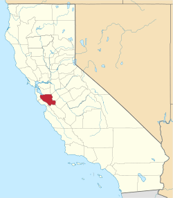 | |
| CDPs | ||
| Unincorporated communities | ||
| CCDs | ||
| Ghost towns | ||
| Bodies of water |
|  |
|---|---|---|
| Counties | ||
| Major cities | ||
| Cities and towns 100k–250k | ||
| Cities and towns 50k–99k | ||
| Cities and towns 25k-50k | ||
| Cities and towns 10k–25k |
| |
| Sub-regions | ||