Mountain Home, Idaho
| Mountain Home, Idaho | |
|---|---|
| City | |
|
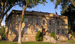
Elmore County Courthouse in 2009 | |
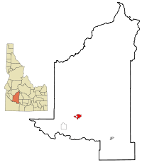 Location in Elmore County and the state of Idaho | |
 Mountain Home, Idaho Location in the United States | |
| Coordinates: 43°8′13″N 115°41′40″W / 43.13694°N 115.69444°WCoordinates: 43°8′13″N 115°41′40″W / 43.13694°N 115.69444°W | |
| Country | United States |
| State | Idaho |
| County | Elmore |
| Government | |
| • Mayor | Rich Sykes[1] |
| Area[2] | |
| • Total | 6.36 sq mi (16.47 km2) |
| • Land | 6.07 sq mi (15.72 km2) |
| • Water | 0.29 sq mi (0.75 km2) |
| Elevation | 3,146 ft (959 m) |
| Population (2010)[3] | |
| • Total | 14,206 |
| • Estimate (2012[4]) | 13,791 |
| • Density | 2,340.4/sq mi (903.6/km2) |
| Time zone | Mountain (MST) (UTC-7) |
| • Summer (DST) | MDT (UTC-6) |
| ZIP code | 83647 |
| Area code(s) | 208 |
| FIPS code | 16-54730 |
| GNIS feature ID | 0374044 |
| Website | Official website |
Mountain Home is the largest city in the county seat of Elmore County, Idaho, USA.[5] The population was 14,206 in the 2010 census. Mountain Home is the principal city of the Mountain Home, Idaho Micropolitan Statistical Area, which includes Elmore County.
Mountain Home was originally a post office at Rattlesnake Station, a stagecoach stop on the Overland Stage Line, about seven miles (11 km) east of the city, on present-day US-20 towards Fairfield. With the addition of the Oregon Short Line Railroad in 1883, the post office was moved downhill and west to the city's present site.[6]
Mountain Home Air Force Base, an Air Combat Command installation, is located 12 miles (20 km) southwest of the city. Opened in 1943 during World War II, the base was originally a bomber training base and later an operational Strategic Air Command bomber and missile base (1953–65). It switched to Tactical Air Command and fighters in January 1966; TAC was succeeded by ACC in 1992.
Geography
Mountain Home is located at 43°8′13″N 115°41′40″W / 43.13694°N 115.69444°W (43.136812, -115.694474),[7] at an elevation of 3,146 feet (959 m) above sea level.
According to the United States Census Bureau, the city has a total area of 6.36 square miles (16.47 km2), of which 6.07 square miles (15.72 km2) is land and 0.29 square miles (0.75 km2) is water.[2]
About 8 miles (13 km) to the northwest are the Crater Rings, a National Natural Landmark.
Mountain Home experiences a semi-arid climate (Köppen BSk) with short, cold winters and hot, dry summers.
| Climate data for Mountain Home (1971–2000) | |||||||||||||
|---|---|---|---|---|---|---|---|---|---|---|---|---|---|
| Month | Jan | Feb | Mar | Apr | May | Jun | Jul | Aug | Sep | Oct | Nov | Dec | Year |
| Average high °F (°C) | 37.6 (3.1) |
44.9 (7.2) |
53.6 (12) |
62.5 (16.9) |
71.6 (22) |
82.3 (27.9) |
91.7 (33.2) |
91.2 (32.9) |
79.5 (26.4) |
66.2 (19) |
48.5 (9.2) |
38.2 (3.4) |
63.98 (17.77) |
| Average low °F (°C) | 20.4 (−6.4) |
24.4 (−4.2) |
29.7 (−1.3) |
35.1 (1.7) |
42.8 (6) |
50.4 (10.2) |
56.7 (13.7) |
55.5 (13.1) |
45.8 (7.7) |
35.4 (1.9) |
26.9 (−2.8) |
20.3 (−6.5) |
36.95 (2.76) |
| Average precipitation inches (mm) | 1.32 (33.5) |
0.97 (24.6) |
1.19 (30.2) |
0.92 (23.4) |
0.86 (21.8) |
0.59 (15) |
0.38 (9.7) |
0.20 (5.1) |
0.68 (17.3) |
0.76 (19.3) |
1.32 (33.5) |
1.38 (35.1) |
10.57 (268.5) |
| Source: NOAA (normals, 1971–2000) [8] | |||||||||||||
Highways

|
Demographics
| Historical population | |||
|---|---|---|---|
| Census | Pop. | %± | |
| 1890 | 233 | — | |
| 1900 | 529 | 127.0% | |
| 1910 | 1,411 | 166.7% | |
| 1920 | 1,644 | 16.5% | |
| 1930 | 1,243 | −24.4% | |
| 1940 | 1,193 | −4.0% | |
| 1950 | 1,887 | 58.2% | |
| 1960 | 5,984 | 217.1% | |
| 1970 | 6,451 | 7.8% | |
| 1980 | 7,540 | 16.9% | |
| 1990 | 7,913 | 4.9% | |
| 2000 | 11,143 | 40.8% | |
| 2010 | 14,206 | 27.5% | |
| Est. 2015 | 13,730 | [9] | −3.4% |
2010 census

At the 2010 census,[3] there were 14,206 people, 5,648 households and 3,686 families residing in the city. The population density was 2,340.4 inhabitants per square mile (903.6/km2). There were 6,249 housing units at an average density of 1,029.5 per square mile (397.5/km2). The racial makeup of the city was 83.2% White, 3.3% African American, 1.0% Native American, 2.9% Asian, 0.6% Pacific Islander, 4.8% from other races, and 4.4% from two or more races. Hispanic or Latino of any race were 11.9% of the population.
There were 5,648 households of which 36.9% had children under the age of 18 living with them, 50.0% were married couples living together, 10.9% had a female householder with no husband present, 4.4% had a male householder with no wife present, and 34.7% were non-families. 27.6% of all households were made up of individuals and 8.1% had someone living alone who was 65 years of age or older. The average household size was 2.49 and the average family size was 3.06.
The median age in the city was 29.8 years. 27.9% of residents were under the age of 18; 12.4% were between the ages of 18 and 24; 29.1% were from 25 to 44; 20.7% were from 45 to 64; and 9.9% were 65 years of age or older. The gender makeup of the city was 51.3% male and 48.7% female.
2000 census
At the 2000 census,[11] there were 11,143 people, 4,337 households and 2,957 families residing in the city. The population density was 2,150.8 per square mile (830.6/km²). There were 4,738 housing units at an average density of 914.5 per square mile (353.2/km²). The racial makeup of the city was 87.89% White, 2.61% African American, 0.94% Native American, 1.73% Asian, 0.31% Pacific Islander, 3.41% from other races, and 3.11% from two or more races. Hispanic or Latino of any race were 8.33% of the population.
There were 4,337 households of which 36.8% had children under the age of 18 living with them, 55.7% were married couples living together, 9.0% had a female householder with no husband present, and 31.8% were non-families. 26.6% of all households were made up of individuals and 7.4% had someone living alone who was 65 years of age or older. The average household size was 2.54 and the average family size was 3.11.

29.6% of the population were under the age of 18, 9.8% from 18 to 24, 32.8% from 25 to 44, 18.1% from 45 to 64, and 9.7% who were 65 years of age or older. The median age was 32 years. For every 100 females there were 101.0 males. For every 100 females age 18 and over, there were 99.5 males.
The median household income was $37,307 and the median family income was $41,485. Males had a median income of $28,724 and females $21,905. The per capita income was $17,029. About 8.6% of families and 10.4% of the population were below the poverty line, including 13.9% of those under age 18 and 11.8% of those age 65 or over.
Notable people
- Richard McKenna - novelist (The Sand Pebbles)
- Ford Rainey - actor
- Victor Wooten - musician
References
- ↑ "Mayor and City Council". City of Mountain Home. 2011. Retrieved July 8, 2016.
- 1 2 "US Gazetteer files 2010". United States Census Bureau. Retrieved December 18, 2012.
- 1 2 "American FactFinder". United States Census Bureau. Retrieved December 18, 2012.
- ↑ "Population Estimates". United States Census Bureau. Retrieved June 3, 2013.
- ↑ "Find a County". National Association of Counties. Retrieved June 7, 2011.
- ↑ Conley, Cort (1982). Idaho for the Curious. p. 417. ISBN 0-9603566-3-0.
- ↑ "US Gazetteer files: 2010, 2000, and 1990". United States Census Bureau. February 12, 2011. Retrieved April 23, 2011.
- ↑ "Climatography of the United States NO.81" (PDF). National Oceanic and Atmospheric Administration. Retrieved January 13, 2011.
- ↑ "Annual Estimates of the Resident Population for Incorporated Places: April 1, 2010 to July 1, 2015". Retrieved July 2, 2016.
- ↑ "Census of Population and Housing". Census.gov. Retrieved June 4, 2015.
- ↑ "American FactFinder". United States Census Bureau. Retrieved January 31, 2008.
External links
| Wikimedia Commons has media related to Mountain Home, Idaho. |
Municipalities and communities of Elmore County, Idaho, United States | ||
|---|---|---|
| Cities | ||
| CDP | ||
| Unincorporated communities | ||