Mount Yonaha
| Mount Yonaha | |
|---|---|
| 与那覇岳 | |
|
Mount Yonaha | |
| Highest point | |
| Elevation | 503 m (1,650 ft) |
| Coordinates | 26°43′1.2″N 128°13′7.2″E / 26.717000°N 128.218667°ECoordinates: 26°43′1.2″N 128°13′7.2″E / 26.717000°N 128.218667°E |
| Naming | |
| Pronunciation | Japanese: [Yonaha-dake] |
| Geography | |
 Mount Yonaha | |
| Climbing | |
| Easiest route | Hiking |
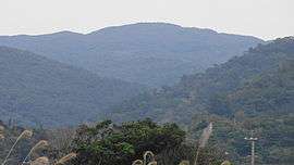
Mount Yonaha (与那覇岳 Yonaha-dake), also known as Mount Yunaha (ユナハダキ Yunaha-daki),[1] is a mountain located in Kunigami on the main island of Okinawa in Okinawa Prefecture. The mountain has an elevation of 503 m (1,650 ft).
Etymology
The name of Mount Yonaha in the Japanese language is formed from three kanji, 与, 那, and 覇. The kanji are ateji, or kanji used phonetically to represent native or borrowed words.
Geography
Mount Yonaha is located approximately 80 km (50 mi) north of the capital of Okinawa Prefecture, Naha,[2] and approximately 4.5 km (3 mi) east of the Okuma district (奥間集落 Okuma shūraku) of Kunigami. Mount Yonaha is formed from schist, phyllite, and sandstone, and dates from the Tertiary period to the mid-Mesozoic era.[3] Mount Yonaha appears to be a gentle slope, but its summit is surrounded by a series of complex valleys.[1] It is the highest mountain on the island and the second highest in the prefecture after Mount Omoto 525.5 m (1,724 ft) in Ishigaki, Okinawa.[3] Mount Yonaha is part of the Okinawa Kaigan Quasi-National Park, and is the highest mountain in the park. A paved mountain road extends from the village of Kunigami at the base of Mount Yonaha to the mountain summit.[3] Mount Yonaha is also home to the largest waterfall on Okinawa Island, the Hiji Waterfall (26 m (85 ft)).[2] Mounta Yonaha, due to the effect of the Kuroshio Current, is almost always covered in fog.[2]
Rivers
- Okuma River (奥間川 Okuma-gawa)
- Hiji River (比地川 Hiji-gawa)
- Toko River (床川 Toko-gawa)
Yanbaru forest
Mount Yonaha is at the center of the Yanbaru forest that spans the villages of Higashi, Kunigami, and Ōgimi. Yanbaru contains some of the last large surviving tracts of subtropical rainforest in Asia, and the mountain is lush with evergreens forests. While Mount Yonaha is an important natural habitat to numerous species of plants, birds, and animals, the ecology of the mountain has been negatively affected by agricultural development at the base of the mountain, and lumbering and the subsequent establishment of second-growth forest.[3]
Military installation
The summit of Mount Yonaha is approximately 2 km (1 mi) west of the border of Camp Gonsalves, a jungle warfare training center of the United States Marine Corps.
External links
- 与那覇岳天然保護区(Japanese)
References
- 1 2 "Yonaha-dake". Nihon Rekishi Chimei Taikei (日本歴史地名大系 “Compendium of Japanese Historical Place Names”) (in Japanese). Tokyo: Shogakukan. 2012. Retrieved 2012-03-16.
- 1 2 3 与那覇岳天然保護区(Japanese)
- 1 2 3 4 "Yonaha-dake". Nihon Daihyakka Zensho (Nipponika) (日本大百科全書(ニッポニカ) “Large Encyclopedia of Japan (Nipponika)”) (in Japanese). Tokyo: Shogakukan. 2012. Retrieved 2012-03-16.