Mount Webster
| Mount Webster | |
|---|---|
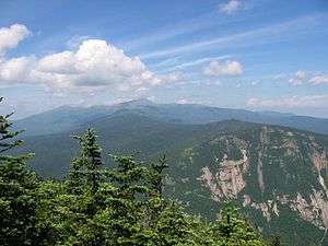 The view from Mt. Willey along the spine of the Presidential Range, from Jefferson (left background) to Webster (right foreground). | |
| Highest point | |
| Elevation | 1,192 m (3,911 ft) |
| Prominence | 46 m (151 ft) |
| Coordinates | 44°11.69′N 71°23.29′W / 44.19483°N 71.38817°WCoordinates: 44°11.69′N 71°23.29′W / 44.19483°N 71.38817°W |
| Geography | |
| Location | Bean's Purchase, Coös County / Hart's Location, Carroll County, New Hampshire, U.S. |
| Parent range | Presidential Range |
| Topo map | USGS Crawford Notch |
Mount Webster is a mountain located on the border between Coos County and Carroll County, New Hampshire. The mountain, formerly called Notch Mountain, is named after Daniel Webster (1782–1852), and is the southwesternmost of the Presidential Range of the White Mountains. Mount Webster is flanked to the northeast by Mount Jackson; to the southwest it faces Mount Willey across Crawford Notch.
The west face of Mount Webster drains directly into the Saco River, thence into the Gulf of Maine at Saco, Maine. The north and southeast faces drain into the Saco via Silver Cascade and Webster Brook respectively.
Mount Webster is on the western boundary of the Presidential Range - Dry River Wilderness. The Appalachian Trail, a 2,170-mile (3,500-km) National Scenic Trail from Georgia to Maine, runs along the ridge of the Presidentials, across the summit of Webster.
See also
External links
- U.S. Geological Survey Geographic Names Information System: Mount Webster
- Mt. Webster on Topozone
- PeakBagger.com: Mt. Webster
- summitpost.org: Mt. Webster