Mount Tabor, Portland, Oregon
| Mount Tabor | |
|---|---|
| Neighborhood | |
|
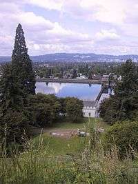
Downtown Portland, Oregon, from on Mt. Tabor Park. | |
 Mount Tabor | |
|
Coordinates: 45°30′46″N 122°35′33″W / 45.5128968°N 122.5925937°WCoordinates: 45°30′46″N 122°35′33″W / 45.5128968°N 122.5925937°W PDF map | |
| Country | United States |
| State | Oregon |
| City | Portland |
| Government | |
| • Association | Mount Tabor Neighborhood Association |
| • Coalition | Southeast Uplift Neighborhood Program |
| Area | |
| • Total | 1.60 sq mi (4.14 km2) |
| Population (2000)[1] | |
| • Total | 10,037 |
| • Density | 6,280/sq mi (2,424/km2) |
| Housing[1] | |
| • No. of households | 4316 |
| • Occupancy rate | 96% occupied |
| • % households renting | 35% renting |
| • Avg. household size | 2.33 persons |
| Race Distribution: White 84.6%, Asian 6.4%, Hispanic 3.5%, Black 1.3% | |

Mount Tabor is the name of a volcanic cinder cone, the city park on the volcano, and the neighborhood of Southeast Portland that surrounds it, all in the U.S. state of Oregon. The name refers to Mount Tabor, Israel. It was named by Plympton Kelly, son of Oregon City pioneer resident Clinton Kelly.[2]
Neighborhood
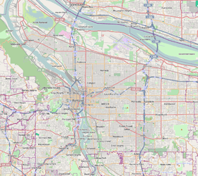
The Mount Tabor neighborhood lies between SE 49th Ave. (SE 50th Ave. south of SE Hawthorne Blvd.) on the west and SE 76th Ave. on the east, and between E Burnside St. on the north and SE Division St. on the south. It is bordered by Sunnyside and Richmond on the west, North Tabor on the north and west, Montavilla on the north and east, and South Tabor on the south.
Mount Tabor Park is the neighborhood's principal feature. The campus of Warner Pacific College (affiliated with the Church of God (Anderson)) is located just south of the park. The neighborhood also marks the eastern end of the Hawthorne District. The campus of Western Seminary is located on the western slope, overlooking downtown Portland.
Before becoming part of Portland in 1905, Mount Tabor was a rural farming community dating back to the 1850s. It became a city-recognized neighborhood (encompassing a far smaller area than its historical boundaries) in 1974.[3]
See also
- Chauncey Hosford, an early owner of the property at the summit of Mt. Tabor
References
- 1 2 Demographics (2000)
- ↑ McArthur, Lewis A.; Lewis L. McArthur (2003) [1928]. Oregon Geographic Names (Seventh ed.). Portland, Oregon: Oregon Historical Society Press. ISBN 0-87595-278-X.
- ↑ "Mt Tabor Neighborhood Association - History: The early years of Mt. Tabor". Mttaborpdx.org. Retrieved 2008-11-04.
Further reading
- Mount Tabor Park in the Oregon Encyclopedia
- Mount Tabor: Architectural Heritage, 1850–1930 (by Jan Caplener)
- The early years of Mount Tabor (by Grant Nelson)
- East Buttes, Terraces And Wetlands Conservation Plan, Bureau of Planning, Portland, Oregon (1993)
External links
| Wikimedia Commons has media related to Mount Tabor, Portland, Oregon. |
- Mount Tabor Cinder Cone, Portland, Oregon (USGS Cascades Volcanic Observatory)
- Friends of the Reservoirs
- Friends of Mount Tabor, a non-profit group founded in 2000
- Closeup of the crater, the half-circle next to the parking lot
- Audio from March 2007 news story on KPOJ, about traffic on Mount Tabor
|