Mount San Cristobal
| Mount San Cristobal | |
|---|---|
 | |
| Highest point | |
| Elevation | 1,470 m (4,820 ft) [1] |
| Listing | Potentially active[2] |
| Coordinates | 14°03′52″N 121°25′36″E / 14.06443°N 121.42680°ECoordinates: 14°03′52″N 121°25′36″E / 14.06443°N 121.42680°E |
| Geography | |
.svg.png) Mount San Cristobal Location within the Philippines | |
| Location | Luzon |
| Country | Philippines |
| Region | CALABARZON |
| Provinces | |
| Municipalities | |
| Geology | |
| Mountain type | Complex volcano |
| Volcanic arc/belt | Macolod Corridor |
| Last eruption | Unknown |
| Climbing | |
| Easiest route | from Dolores, Quezon |
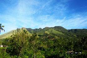
Mount San Cristobal is a dormant volcano in Quezon province on the island of Luzon, Philippines. The mountain rises to an elevation of 1,470 m (4,820 ft) above mean sea level [1] and is one of the volcanic features of Macolod Corridor.[3]
Mount San Cristobal is considered the Devil's mountain in Filipino folklore. It is the alter-ego of the Holy Mountain,[1] Mount Banahaw, and is part of Mounts Banahaw–San Cristobal Protected Landscape covering 10,901 hectares (26,940 acres) of land.
The mountain is bounded by San Pablo, province of Laguna at its northern slope and Dolores, province of Quezon at its southern slope.

7 lakes of San Pablo City, Laguna as seen from the top of Mt. San Cristobal at 1470 meters above sea level.
See also
- List of mountains in the Philippines
- List of national parks of the Philippines
- List of reportedly haunted locations in the Philippines
References
- 1 2 3 "Mt. Cristobal (1,470+)". Pinoy Mountaineer. 23 September 2007. Retrieved 5 February 2015.
- ↑ "Potentially Active". Philippine Institute of Volcanology and Seismology. 30 July 2008. Retrieved 24 March 2016.
- ↑ Tectonophysics. Amsterdam: Elsevier Science Publishers. 1990. p. 266.
External links
| Wikimedia Commons has media related to Mount San Cristobal. |
This article is issued from Wikipedia - version of the 9/11/2016. The text is available under the Creative Commons Attribution/Share Alike but additional terms may apply for the media files.