Mount Pleasant, Iowa
| Mount Pleasant, Iowa | |
|---|---|
| City | |
|
Mount Pleasant, Iowa | |
| Motto: Pursuing excellence | |
 Location of Mount Pleasant, Iowa | |
| Coordinates: 40°58′1″N 91°33′4″W / 40.96694°N 91.55111°WCoordinates: 40°58′1″N 91°33′4″W / 40.96694°N 91.55111°W | |
| Country |
|
| State |
|
| County | Henry |
| Incorporated | July 15, 1856 [1] |
| Government | |
| • Mayor | Steve Brimhall |
| Area[2] | |
| • Total | 8.53 sq mi (22.09 km2) |
| • Land | 8.51 sq mi (22.04 km2) |
| • Water | 0.02 sq mi (0.05 km2) |
| Elevation | 715 ft (218 m) |
| Population (2010)[3] | |
| • Total | 8,668 |
| • Estimate (2012[4]) | 8,741 |
| • Density | 1,018.6/sq mi (393.3/km2) |
| Time zone | Central (CST) (UTC-6) |
| • Summer (DST) | CDT (UTC-5) |
| ZIP code | 52641 |
| Area code(s) | 319 |
| FIPS code | 19-54705 |
| GNIS feature ID | 0459328 |
| Website | City of Mount Pleasant |

Mount Pleasant is a city in and the county seat of Henry County, Iowa, in the United States.[5] The population was 8,668 in the 2010 census, a decline from 8,751 in the 2000 census.[6][7] It was founded in 1835 by pioneer Presley Saunders.
History
Mount Pleasant was first incorporated as a town by European Americans in 1842, and again in 1851.[8]
In 1869, Mount Pleasant was the site of a solar eclipse expedition, under the command of James Craig Watson and sponsored by National Almanac. The total solar eclipse occurred on August 7, 1869.[9]
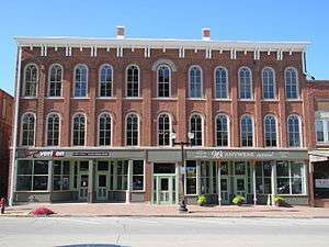
In the Union Block building in 1869, Arabella A. Mansfield became the first woman in the United States to be awarded a license to practice law. She had passed the bar exam with high scores and won a court case for entry to the bar. The legislature changed its statute.
The third floor of the Union Block housed the Opera House or Union Hall, a gathering place for the community. It attracted national speakers on tour, including abolitionists Frederick Douglass, Sojourner Truth, and Anna Dickinson. James Harlan also spoke there, as he was president of Iowa Wesleyan College in the town, and later was elected several times to the United States Senate. This building had been considered one of the most endangered historic sites in Iowa.[10]
The Mount Pleasant Mental Health Institute was built in 1861. However, in 1936, a fire did great damage to the building. The hospital had to be closed, as little of the facility survived the fire.[11]
On December 10, 1986, Ralph Orin Davis, a resident, walked into a city council meeting and shot Mayor Edward King and two council members. Mayor King died of his wounds after being shot point blank in the head. The 69-year-old gunman had attended a couple of previous meetings, complaining about a backed-up sewer and wanting the city to pay for damages to his house. The two council members were seriously wounded.[12] Tom Vilsack was the replacement mayor, later becoming governor for 8 years then Secretary of Agriculture for 8 years.[13]
Geography
According to the United States Census Bureau, the city has a total area of 8.53 square miles (22.09 km2), of which, 8.51 square miles (22.04 km2) is land and 0.02 square miles (0.05 km2) is water.[2]
Mount Pleasant's population density is estimated at 1123 people per square mile which is considered low for urban areas.[1]
Demographics
| Historical population | |||
|---|---|---|---|
| Census | Pop. | %± | |
| 1850 | 758 | — | |
| 1860 | 3,530 | 365.7% | |
| 1870 | 4,245 | 20.3% | |
| 1880 | 4,410 | 3.9% | |
| 1890 | 3,997 | −9.4% | |
| 1900 | 4,109 | 2.8% | |
| 1910 | 3,874 | −5.7% | |
| 1920 | 3,987 | 2.9% | |
| 1930 | 3,743 | −6.1% | |
| 1940 | 4,610 | 23.2% | |
| 1950 | 5,843 | 26.7% | |
| 1960 | 7,339 | 25.6% | |
| 1970 | 7,007 | −4.5% | |
| 1980 | 7,322 | 4.5% | |
| 1990 | 8,027 | 9.6% | |
| 2000 | 8,751 | 9.0% | |
| 2010 | 8,668 | −0.9% | |
| Est. 2015 | 8,433 | [14] | −2.7% |
2010 census
As of the census[3] of 2010, there were 8,668 people, 3,127 households, and 1,935 families residing in the city. The population density was 1,018.6 inhabitants per square mile (393.3/km2). There were 3,365 housing units at an average density of 395.4 per square mile (152.7/km2). The racial makeup of the city was 85.7% White, 4.3% African American, 0.4% Native American, 4.4% Asian, 0.3% Pacific Islander, 2.4% from other races, and 2.5% from two or more races. Hispanic or Latino of any race were 6.7% of the population.
There were 3,127 households of which 30.5% had children under the age of 18 living with them, 46.1% were married couples living together, 10.8% had a female householder with no husband present, 4.9% had a male householder with no wife present, and 38.1% were non-families. 33.3% of all households were made up of individuals and 15% had someone living alone who was 65 years of age or older. The average household size was 2.31 and the average family size was 2.94.
The median age in the city was 37.3 years. 21.1% of residents were under the age of 18; 12.3% were between the ages of 18 and 24; 26.5% were from 25 to 44; 24.8% were from 45 to 64; and 15.3% were 65 years of age or older. The gender makeup of the city was 52.7% male and 47.3% female.
2000 census
As of the census[16] of 2000, there were 8,751 people, 3,119 households, and 1,940 families residing in the city. The population density was 1,137.3 people per square mile (439.4/km²). There were 3,355 housing units at an average density of 436.0 per square mile (168.4/km²). The racial makeup of the city was 90.46% White, 3.19% African American, 0.32% Native American, 3.53% Asian, 0.06% Pacific Islander, 0.73% from other races, and 1.71% from two or more races. Hispanic or Latino of any race were 1.79% of the population.
There were 3,119 households out of which 31.4% had children under the age of 18 living with them, 49.3% were married couples living together, 9.9% had a female householder with no husband present, and 37.8% were non-families. 33.2% of all households were made up of individuals and 14.3% had someone living alone who was 65 years of age or older. The average household size was 2.34 and the average family size was 3.01.
Age spread: 22.5% under the age of 18, 11.6% from 18 to 24, 31.5% from 25 to 44, 20.2% from 45 to 64, and 14.1% who were 65 years of age or older. The median age was 36 years. For every 100 females there were 110.0 males. For every 100 females age 18 and over, there were 113.6 males.
The median income for a household in the city was $35,558, and the median income for a family was $46,063. Males had a median income of $31,524 versus $22,628 for females. The per capita income for the city was $16,824. About 8.3% of families and 10.2% of the population were below the poverty line, including 11.5% of those under age 18 and 9.4% of those age 65 or over.
Arts and culture

Mount Pleasant is also home to the Midwest Old Thresher's Reunion which attracts a crowd numbering over 100,000 admissions annually during an extended five-day weekend which ends on Labor Day. The reunion dates back to 1950 and pays tribute to the agricultural heritage of the American Midwest in an extensive, highly interactive manner, with live-action exhibition-style displays centering on restored mechanical equipment, particularly steam engines, farm tractors, stationary gas engines, antique and classic cars, the narrow-gauge Midwest Central Railroad, and electric trolleys. Country music shows featuring top-name performers, an expansive modern campground with transportation to the main grounds, and an extensive food court and numerous other offerings (run entirely by local churches and nonprofit organizations) are some of the amenities Old Threshers guests enjoy.
Economy
A meat processing plant operated by West Liberty Foods is located in Mount Pleasant. South of the city is the Mount Pleasant Correctional Facility, a medium-security state prison that in the year 2010 housed approximately ±875 male and ±100 female inmates, and employed ±340 staff.[17] The Mount Pleasant Mental Health Institute is also located on the same campus.
Education
Public schools
The public school system in Mount Pleasant is administered by the Mount Pleasant Community School District. The district oversees the High school, Middle school, four elementary schools, Harlan, Lincoln, Salem, and Van Allen and the WisdomQuest Education Center.[18]
Advanced education
The city is home to Iowa Wesleyan University, which, founded in 1842, ranks as the oldest coeducational college/university west of the Mississippi River. The P.E.O. Sisterhood, an international philanthropic organization for women, was founded on the campus in Mount Pleasant by seven Iowa Wesleyan students.
Transportation
Amtrak, the national passenger rail system, provides service to Mount Pleasant, operating its California Zephyr daily in both directions between Chicago, Illinois, and Emeryville, California, across the bay from San Francisco.
U.S. Route 34 bypasses Mount Pleasant to the north, while U.S. Route 218/Iowa Highway 27 bypass the city to the east. These highways' former routes through the city are now designated as business routes.
The Mount Pleasant Municipal Airport (FAA Identifier: MPZ) is at an elevation of 730 ft (222.5 m) and is located 3 miles (4.8 km) southeast of the city. The airport started operations in March 1945. As of May 2014 it has 2 runways: Runway 15/33 is hard surfaced (asphalt) and is 4001 ft long x 75 ft wide (1220m x 23m) with runway edge lights; Runway 03/21 is turf and is 1965 ft long x 120 ft wide (599m x 37m) marked by yellow cones.[19]
Notable people
- James Van Allen (1914–2006) – considered America's foremost space scientist.[20]
- Warren Wallace Beckwith (1874-1955) - athlete, husband of Abraham Lincoln's granddaughter.
- Tom Vilsack – former Mount Pleasant mayor, former governor of Iowa, and current United States Secretary of Agriculture.[21]
- Arabella Mansfield (1846–1911) – first female lawyer in the United States.[22]
- James Harlan (1820-1899) – politician, president of Iowa Wesleyan College.
- Mary Eunice Harlan (1846-1937) – daughter of James Harlan; wife of Robert Todd Lincoln.
- Dana Holgorsen – head coach for the West Virginia University football team.[23][24]
- Leigh S. J. Hunt (1855-1933) – Superintendent of Schools in the 1880s.
- Carolyn Pendray (1881-1958) - first woman elected to the Iowa General Assembly.[25]
- Ab Saunders (1851-1883) - Wild West cowboy and outlaw.
- Frederick A. Shannon (1921-1965) – herpetologist.
References
- 1 2 "City Data". Hospers. Retrieved 2010-12-21.
- 1 2 "US Gazetteer files 2010". United States Census Bureau. Retrieved 2012-05-11.
- 1 2 "American FactFinder". United States Census Bureau. Retrieved 2012-05-11.
- ↑ "Population Estimates". United States Census Bureau. Archived from the original on 2013-06-17. Retrieved 2013-05-23.
- ↑ "Find a County". National Association of Counties. Archived from the original on 2015-05-10. Retrieved 2011-06-07.
- ↑ "Population & Housing Occupancy Status 2010". United States Census Bureau American FactFinder. Archived from the original on 2011-07-21. Retrieved 2011-07-08.
- ↑ "Data from the 2010 Census". State Data Center of Iowa. Retrieved 2011-07-08.
- ↑ The History of Henry County, Iowa: Containing a History of the County, Its Cities, Towns, &c. Western Historical Company. 1879. p. 504.
- ↑ Wikisource:''Popular Science Monthly''/Volume 19/September 1881/"Sketch of James Craig Watson"
- ↑ It reopened in August of 2014 housing businesses on the first and second floors. The ballroom was restored and updated on the third floor making it a beautiful hall used for a variety of community gatherings, events, and private parties. "2008 Most Endangered Properties", Preservation Iowa,
- ↑
- ↑ "Mayor killed, 2 hurt in meeting gunfire", Kentucky New Era, 6 December 1986
- ↑ http://www.desmoinesregister.com/story/news/local/kyle-munson/2015/10/23/mount-pleasant-fountain-mayor-edd-king-shooting-tom-vilsack/74274030/
- ↑ "Annual Estimates of the Resident Population for Incorporated Places: April 1, 2010 to July 1, 2015". Retrieved July 2, 2016.
- ↑ "Census of Population and Housing". Census.gov. Archived from the original on May 11, 2015. Retrieved June 4, 2015.
- ↑ "American FactFinder". United States Census Bureau. Archived from the original on 2013-09-11. Retrieved 2008-01-31.
- ↑ "Iowa Department of Corrections". Institution Descriptions. Advanced Technologies Group, Inc. Retrieved 2010-12-21.
- ↑ "Mt. Pleasant Community School District". Homepage. Retrieved 2010-12-21.
- ↑ "KMPZ Mount Pleasant Municipal Airport". AirNav, LLC. Retrieved 2011-07-08.
- ↑ Van Allen, James A. "What Is A Space Scientist? An Autobiographical Example (Parentage, Boyhood, and Early Education)". Retrieved 2007-12-06.
- ↑ Okamoto, Lynn (2009-10-15). "Vilsack biography". Des Moines Register. Retrieved 2010-12-16.
- ↑ "JRank". Arabella Mansfield - A Commanding Presence. Retrieved 2010-12-16.
- ↑ Hickman, Dave (December 15, 2010). "At previous stops, Holgorsen's impact has been felt right away". Charleston Gazette. Archived from the original on June 22, 2011. Retrieved 2010-12-21.
- ↑ "Oklahoma State University". Athletic Department. Retrieved 2010-12-21.
- ↑ Frommelt, A.G.; Elijah, Earl; Long, Irving D. (1959). "Senator Carolyn Campbell Pendray". Iowa Legislature.
External links
| Wikimedia Commons has media related to Mount Pleasant, Iowa. |
Municipalities and communities of Henry County, Iowa, United States | ||
|---|---|---|
| Cities | ||
| Unincorporated community | ||
| Footnotes | ‡This populated place also has portions in an adjacent county or counties | |