Mount Pelée
| Mount Pelée hey | |
|---|---|
 | |
| Highest point | |
| Elevation | 1,397 m (4,583 ft) [1] |
| Prominence | 1,397 m (4,583 ft) |
| Coordinates | 14°49′0″N 61°10′0″W / 14.81667°N 61.16667°WCoordinates: 14°49′0″N 61°10′0″W / 14.81667°N 61.16667°W |
| Geography | |
 Mount Pelee | |
| Geology | |
| Mountain type | Stratovolcano |
| Volcanic arc/belt | Lesser Antilles Volcanic Arc |
| Last eruption | 1929–1932 [1] |
| Climbing | |
| Easiest route | walk |
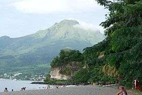
Mount Pelée (pronounced /pəˈleɪ/; French: Montagne Pelée meaning "bald mountain" or "peeled" mountain"[2]) is a semi-active volcano at the northern end of Martinique, an island and French overseas department in the Lesser Antilles island arc of the Caribbean. Its volcanic cone is composed of layers of volcanic ash and hardened lava.[3] The volcano is currently in a quiescent state, which means it is not active, but is registering seismic activity.[4]
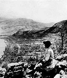
The stratovolcano is famous for its eruption in 1902 and the destruction that resulted, dubbed the worst volcanic disaster of the 20th century.[5][6][7] The eruption killed about 30,000 people.[8][9] Most deaths were caused by pyroclastic flows which completely destroyed the city of Saint-Pierre (at that time, the largest city on the island.[10][11]), within minutes of the eruption.[12]
The eruption left only two survivors in the direct path of the flows: Louis-Auguste Cyparis survived because he was in a poorly ventilated, dungeon-like jail cell; Léon Compère-Léandre, living on the edge of the city, escaped with severe burns.[13] Havivra Da Ifrile, a young girl, reportedly escaped with injuries during the eruption by taking a small boat to a cave down shore, and was later found adrift two miles (3 km) from the island, unconscious. The event marked the only major volcanic disaster in the history of France and its overseas territories.
Geographical setting and description
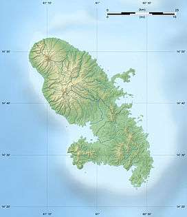
Mount Pelée is the result of a typical subduction zone. The subduction formed the Lesser Antilles island arc, a curved chain of volcanoes approximately 850 kilometres (530 mi) in length, between Puerto Rico and Venezuela, where the Caribbean Plate meets Atlantic Oceanic crust belonging to the South American Plate. Other volcanoes in the island arc are also known for their volcanic activity, including Saint Vincent's La Soufrière, Guadeloupe's La Grande Soufriere volcano, Montserrat's Soufrière Hills, and the submarine volcano Kick 'em Jenny.[3]
Geological history
Volcanologists have identified three different phases in the evolution of mount Pelée volcano: initial, intermediate, and modern.[3] In an initial phase, called the "Paléo-Pelée" stage, Mount Pelee was a common stratovolcano. The cone of Paléo-Pelée was composed of many layers of lava flows and fragmented volcanic debris. Remains of the Paléo-Pelée cone are still visible at the northern view at the volcano today.
A second stage, now called the intermediate phase, started around 100,000 years ago, after a long period of quiescence. This stage is grouped by the formation of the Morne Macouba lava dome, then later on, the Morne Macouba caldera. During the intermediate phase, there were several eruptions which produced pyroclastic flows like those that destroyed Saint-Pierre in the 1902 eruption. Around 25,000 years ago, a large southwest sector collapse occurred, forming a landslide. This event is similar to the eruption of Mount Saint Helens in 1980.[3]
The modern stage of the evolution of Mount Pelée has created most of the current cone, with deposits of pumice and the results of past pyroclastic flows. More than 30 eruptions have been identified during the last 5,000 years of the volcano's activity.
3,000 years ago, following a large pumice eruption, the Étang Sec (French for Dry Pond) caldera was then formed. The 1902 eruption took place within the Étang Sec crater. This eruption formed many pyroclastic flows and produced a dome which filled the caldera.
The following eruption in 1929 formed a second dome in the Étang Sec caldera, and produced pyroclastic flows emptying into the Blanche River valley. This last eruption is mainly responsible for the current state of Mount Pelée.[3]
1902 eruption

Before the tragic 1902 eruption, as early as the summer of 1900, signs of increased fumarole activity were present in the Étang Sec (Dry Pond) crater near the summit.[14] Relatively minor phreatic (steam) eruptions that occurred in 1792 and 1851 were evidence that the volcano was active and potentially dangerous. Local natives, the Carib people, knew it as "fire mountain" from previous eruptions in ancient times.
Mount Pelée began its eruptions on April 23, 1902. In early April, excursionists noted the appearance of sulfurous vapors emitting from fumaroles near the mountaintop. This was not regarded as important, as fumaroles had appeared and disappeared in the past.
On April 23, the mountain caused a light rain of cinders on its southern and western side, together with sharp underground shocks.
On April 25, the mountain emitted a large cloud containing rocks and ashes from its top, where the Étang Sec caldera was located. The ejected material did not cause a significant amount of damage.
On April 26, the area was dusted by volcanic ash from an eruption; the public authorities still did not see a reason to worry.
On April 27, several excursionists climbed the mountaintop to find Étang Sec filled with water, forming a lake 180 m (590 ft) across. There was a 15 m (50 ft) high cone of volcanic debris built up on one side, feeding the lake with a steady stream of boiling water. Sounds resembling a cauldron with boiling water were heard from deep underground. The strong smell of sulfur was all over the city, 6.4 km (4.0 mi) away from the volcano, causing discomfort to people and horses.
On April 30, Rivière des Pères and the river Roxelane swelled, carrying boulders and trees from the mountaintop. The villages of Prêcheur and Sainte-Philomène received a steady stream of ash.
At 11:30 p.m. on May 2, the mountain produced loud explosions, earthquakes, and a massive pillar of dense black smoke. Ashes and fine-grained pumice covered the entire northern half of the island. The detonation continued in 5-6 hour intervals. This led the local newspaper Les Colonies to indefinitely postpone the proposed picnic on the mountain, originally planned for May 4. Farm animals started dying from hunger and thirst, as their sources of water and food were contaminated with ash.
On Saturday, May 3, the wind blew the ash cloud northwards, alleviating the situation in Saint-Pierre. The next day the ash fall intensified, and the communication between Saint-Pierre and the Prêcheur district was severed. The ash cloud was so dense that the coastal boats feared to navigate through it. Many citizens decided to flee the city, filling the steamer lines to capacity. The area was covered with a layer of fine, flour-like white ash.
On Monday, May 5, the mountain apparently calmed down somewhat; however, at about 1 PM, the sea suddenly receded about 100 metres (330 ft) and then rushed back, flooding parts of the city, and a large cloud of smoke appeared westwards of the mountain. One wall of the Étang Sec crater collapsed and propelled a mass of boiling water and mud, or lahar, into Blanche River, flooded the Guérin sugar works and buried about 150 victims under 60 metres (200 ft) to 90 metres (300 ft) of mud. Refugees from other areas rushed into Saint-Pierre. That night, the atmospheric disturbances disabled the electric grid, sank the city into darkness and added to the confusion.
The next day, at about 2 AM, loud sounds were heard from within the depth of the mountain.
On Wednesday, May 7, at around 4 AM, the mountain stepped up its activity; the clouds of ash caused numerous bolts of volcanic lightning around the mountaintop, and both the craters glowed reddish orange into the night. Through the day, people were leaving the city, but more people from the countryside were attempting to find refuge in the city, increasing its population by several thousand. The newspapers still claimed the city was safe. News of the volcano Soufrière erupting on the nearby Saint Vincent island reassured the people that the internal pressures in the mountain were being relieved. Not everyone was reassured. Captain Marina Leboffe, of the barque Orsolina, left the harbor with only half of the sugar cargo loaded, despite shippers' protests, clearance refused by the port authorities, and threats of being arrested, as were many other civilians refused permission to exit town.[13] Governor Louis Mouttet and his wife stayed in the city. By the evening, the mountain's tremors seemed to calm down again.


The main eruption
On May 8, 1902, Ascension Day, a volcanic eruption destroyed the town of Saint-Pierre, about 6.4 kilometres (4.0 mi) south of the summit.
In the morning, people were observing the fireworks the mountain was displaying. The night shift telegraph operator was sending the reports of the volcano's activity to the operator at Fort-de-France, claiming no significant new developments; his last transmission was at 7:52 was "Allez", handing over the line to the remote operator.[15] In the next second, the telegraph line went dead. A cable repair ship had the city in direct view; the upper mountainside ripped open and a dense black cloud shot out horizontally.[13] A second black cloud rolled upwards, forming a gigantic mushroom cloud and darkening the sky in a 50-mile (80 km) radius. The initial speed of both clouds was later calculated to be over 670 kilometres (420 mi) per hour. The horizontal pyroclastic surge hugged the ground and sped down towards the city of Saint-Pierre, appeared black and heavy, glowing hot from the inside. It consisted of superheated steam and volcanic gases and dust, with temperatures exceeding 1,075 °C (1,967 °F). In under a minute it reached and covered the entire city, instantly igniting everything flammable with which it came in contact.
A rush of wind followed, this time towards the mountain. Then came a half-hour downpour of muddy rain mixed with ashes. For the next several hours, all communication with the city was severed. Nobody knew what was happening, nor who had authority over the island, as the governor was unreachable and his status unknown.
There are unnamed eyewitnesses to the eruption, probably survivors on the boats at the time of the eruption. One eyewitness said "the mountain was blown to pieces, there was no warning," while another said "it was like a giant oil refinery." One person even went as far to say that "the town vanished before our eyes."[16]
The area devastated by the pyroclastic cloud covered about 8 square miles (21 km2), with the city of Saint-Pierre taking the brunt of the damage.
At the time of the eruption, Saint-Pierre had a population of about 28,000, which had swollen with refugees from the minor explosions and mud flows first emitted by the volcano. Legend has previously reported that out of the 30,000 in the city, there were only two survivors: Louis-Auguste Cyparis, a felon held in an underground cell in the town's jail for wounding a friend with a cutlass, and Léon Compère-Léandre, a man who lived at the edge of the city.[13] In reality, there were a number of survivors who made their way out of the fringes of the blast zone. Many of these survivors were horribly burned, and some died later from their injuries. A number made their way to Le Carbet, just south of St. Pierre behind a ridge that protected that town from the worst of the pyroclastic flow; survivors were rescued on the beach there by Martinique officials.[17]
Compère-Léandre stated the following when asked about his survival:
I felt a terrible wind blowing, the earth began to tremble, and the sky suddenly became dark. I turned to go into the house, with great difficulty climbed the three or four steps that separated me from my room, and felt my arms and legs burning, also my body. I dropped upon a table. At this moment four others sought refuge in my room, crying and writhing with pain, although their garments showed no sign of having been touched by flame. At the end of 10 minutes one of these, the young Delavaud girl, aged about 10 years, fell dead; the others left. I got up and went to another room, where I found the father Delavaud, still clothed and lying on the bed, dead. He was purple and inflated, but the clothing was intact. Crazed and almost overcome, I threw myself on a bed, inert and awaiting death. My senses returned to me in perhaps an hour, when I beheld the roof burning. With sufficient strength left, my legs bleeding and covered with burns, I ran to Fonds-Saint-Denis, six kilometers from Saint-Pierre.[13]
One woman, a housemaid, also survived the pyroclastic flow but perished soon after. She said that the only thing she remembered from the event was sudden heat. She died very shortly after being discovered. A third reported survivor was Havivra Da Ifrile, a 10-year-old girl who had rowed to shelter in a cave. Included among the victims were the passengers and crews of several ships docked at Saint-Pierre.
One passenger steamship, the Roraima, which went missing on April 26, was believed to have been engulfed by ash from a preliminary explosion. However, it reached the port of Saint-Pierre at 6:30 AM, shortly before the eruption, and was set aflame by the pyroclastic flow. It later sank; its wreck is still present offshore of Saint-Pierre. Twenty-eight of her crew, and all the passengers except two (a little girl and her creole nurse), were killed by the cloud.[13]
Relief
At about 12:00 noon the acting governor of Martinique sent the warship Suchet to investigate what had happened and the warship arrived off the burning town at about 12.30 p.m. The fierce heat beat back landing parties until nearly 3 p.m., when the captain came ashore on the Place Bertin, the tree-shaded square with cafés near the center of town. Not a tree was standing; the denuded trunks, scorched and bare, lay prone, torn out by the roots. The ground was littered with dead. Fire and a suffocating stench prevented any deeper exploration of the burning ruins.
Meanwhile, a number of survivors had been plucked from the sea by small boats; they were sailors who had been blown into the water by the impact of the blast, and who had clung to wreckage for hours. All were badly burned. In the village of Carbet, shielded from the fiery cloud by a high promontory at the southern end of the city, were more victims, also horribly burned; few of these lived longer than a few hours.
The area of devastation covered about eight square miles. Inside this area, the annihilation of life and property was total; outside was a second, clearly defined zone where there were casualties, but the material damage was less, while beyond this lay a strip in which vegetation was scorched but life was spared.
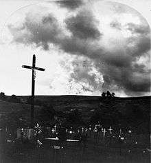
Many victims were in casual attitudes, their features calm and reposeful, indicating that death had overtaken them without warning and without pain; others were contorted in anguish. The clothing had been torn from nearly all the victims struck down outdoors. Some houses were almost pulverized; it was impossible even for persons familiar with the city to identify the foundations of the city landmarks. The city burned for days. Sanitation parties penetrated the calcined ruins bit by bit, to dispose of the dead by burning; burial was out of the question. The stench was sickening. Thousands of victims lay under a shroud of ashes, heaped in windrows several feet deep, caked by the rains; many of these bodies were not retrieved for weeks, and few were identifiable.
The United States quickly offered help to Martinique authorities. On May 12, US president Theodore Roosevelt instructed the Secretaries of War, Navy, and Treasury to start relief measures at once.[18] U.S. cruiser Cincinnati, lying at Santo Domingo, and the Navy tug Potomac at San Juan, Puerto Rico, were ordered to proceed to the disaster area as soon as possible. President Roosevelt asked Congress for an immediate appropriation of $500,000 for emergency assistance to the victims of the calamity. The President said: "One of the greatest calamities in history has befallen our neighboring island of Martinique ... The city of St. Pierre has ceased to exist ... The government of France ... informs us that Fort-de-France and the entire island of Martinique are still threatened. They therefore request that, for the purpose of rescuing the people who are in such deadly peril and threatened with starvation, the government of the United States may send as soon as possible the means of transporting them from the stricken island."
Congress voted for $200,000 of immediate assistance and set hearings to determine what larger sum might be needed when the full nature of the disaster could be learned. In an appeal for public funds the President empowered postmasters to receive donations for relief of the victims; a national committee of prominent citizens took charge of chartering supply ships. Canada, the UK, Germany, France, Italy, Denmark, Japan, Russia, and the Vatican also offered help.
Subsequent activity

On May 20, 1902, a second eruption equal to the first one in both type and force obliterated what was left of Saint-Pierre, killing 2000 rescuers, engineers, and mariners bringing supplies to the island.[19] During a powerful eruption on August 30, 1902, a pyroclastic flow extended further east than the flows of 8 and 20 May. Although not quite as powerful as the previous two eruptions, the August 30 pyroclastic flow struck Morne Rouge (at least 800 fatalities),[20] Ajoupa-Bouillon [21] (250 fatalities),[20] and parts of Basse-Pointe (25 fatalities) and Morne-Capot (10 fatalities).[20] A tsunami caused some damage in Carbet.[21] To date, this was the last fatal eruption of Mount Pelée.[20]
The study of the causes of the disaster marked the beginning of modern volcanology with the definition and the analysis of the deadliest volcanic hazard: the pyroclastic flows and surges, also known as nuées ardentes (Fr: burning clouds). The eruption also lent its name to the "Peléan eruption style". Among those who studied Mount Pelée were Angelo Heilprin and Antoine Lacroix. Lacroix was the first to describe the nuée ardente (pyroclastic flow) phenomenon.[22]
The destruction caused by the 1902 eruption was quickly publicized by recent modern means of communication. It brought to the attention of the public and governments the hazards and dangers of an active volcano.
Mount Pelée continued to erupt until July 4, 1905. Thereafter, the volcano took a rest and gave off no more than steam until 1929.[23]
On September 16, 1929, Mount Pelée began to erupt again. This time, there was no hesitation on the part of authorities and the danger area was immediately evacuated. Although there were pyroclastic flows, the activity was not as violent as the 1902 activity. It culminated in another "spine" or lava plug, albeit smaller than the 1902 plug, being emplaced at the summit. The activity ended in late 1932.[24]
Volcanic spine

Beginning in October 1902, a dramatic volcanic spine grew from the crater floor in the Étang Sec crater, reaching a maximum width of about 100 to 150 m (300 to 500 ft) and a height of about 300 m (1,000 ft). Called the "Needle of Pelée" or "Pelée's Tower", this extraordinary volcanic feature rose up to 15 m (50 ft) a day, and became twice the height of the Washington Monument and more or less the same volume as the Great Pyramid of Egypt. It became unstable and collapsed into a pile of rubble in March 1903,[25] after 5 months of growth.
Current status
As of 2013, the volcano currently lies quiescent above Saint-Pierre and Martinique. Before the 1902 eruption—as early as the summer of 1900—signs of increased fumarole activity were present in the Étang Sec crater (Scarth, p. 30). Relatively minor phreatic (steam) eruptions that occurred in 1792 and 1851 were evidence that the volcano was active. Signs of unrest will almost certainly precede any future eruptive activity from Mount Pelée, and its past activity (including the violent eruptions uncovered by carbon dating) is an extremely important factor for hazard assessment.[26]
A few volcanic earthquakes occur on Martinique every year, but Mount Pelée is under continuous watch by geophysicists and volcanologists (IPGP). As researcher Jean-Pierre Viode states, the volcanic observatory on Martinique would be able to observe activity months before an actual eruption.[27]
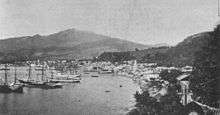
The city of Saint-Pierre was never fully rebuilt, though some villages grew up in its place. The estimated population of Commune of Saint-Pierre in 2004 was 4,544.
Biology
_(14595295848).jpg)
The Martinique volcano frog, Allobates chalcopis, is endemic to Mount Pelée,[28] and the only species among related frogs (family Aromobatidae) endemic to an oceanic island.[29]
In literature
- Martinique Island by Rex Bestle. Book based on the volcanic eruption of Mount Pelée, when it erupted on May 8, 1902 killing over 30,000 people.
- The Day The World Ended by Gordon Thomas and Max Morgan Witts (Stein and Day, 1969, 306 pp). The authors used contemporary records and survivor accounts to construct a historically accurate novel of the events and lives of residents of Martinique, leading up to and through the tragic eruption of May 8, 1902.
- Texaco by Patrick Chamoiseau (Gallimard, 1992. Trans. Rose-Myriam Réjouis and Val Vinokurov, Vintage International, 1998). In this novel that retraces several generations of Martinique's history, Esternome, the protagonist of the novel's first part, witnesses firsthand the destruction caused by the volcano. Marie-Sophie Laborieux, Esternome's daughter and the novel's narrator, recounts her father's experiences and also discusses the traces of this event she has seen herself, including burn scars on her father's body and ossuaries in the ruins of Saint-Pierre. The eruption and its aftermath are discussed in the section "Amour grillée" ("Barbecued Love").
- The Last Moon by DeAnn Lubell (xLibris, 2011). Historical fiction that provides a glimpse and refreshes the memory of those who have witnessed the picturesque splendor of St. Pierre.
- Heat, by Jean Rhys.
See also
- List of volcanic eruptions by death toll
- List of volcanoes in Martinique
- Mount Pinatubo
- Mount Vesuvius
References
- 1 2 "Pelée". Global Volcanism Program. Smithsonian Institution. Retrieved 2008-12-06.
- ↑ Scarth, Alwyn (2002). La Catastrophe: The Eruption of Mount Pelee, the Worst Volcanic Eruption of the Twentieth Century. Oxford: Oxford University Press. p. 2. ISBN 0-19-521839-6.
- 1 2 3 4 5 "Mount Pelee". Mount-pelee.com.
- ↑ https://www.ngdc.noaa.gov/hazard/stratoguide/glossary.html
- ↑
- ↑ Wright, Pierson (1992). USGS Circular 1073. USGS. p. 39.
- ↑ Tilling (1985). Volcanoes. USGS. pp. 16–17.
- ↑ "USGS document of the 1902 eruption of Mount Pelee". USGS.
- ↑ Tilling (1985). Volcanoes. USGS.
- ↑ Blong, R.J. (1984). Volcanic Hazards: A Sourcebook on the Effects of Eruptions. Orlando, Florida: Academic Press.
- ↑ Wright,Pierson (1992). Living With Volcanoes: USGS Circular 1073. USGS.
- ↑ Heilprin, Angelo (1903). Mont Pelee And The Tragedy Of Martinique. Philadelphia: J. B. Lippincott Company. Retrieved 2009-08-15.
- 1 2 3 4 5 6 "The eruption of Mount Pelee". SDSU.
- ↑ Scarth, Alwyn (2002). La Catastrophe. Oxford. p. 30.
- ↑ Zebrowski Jr., Ernest; The Last Days of St. Pierre-The Volcanic Disaster that Claimed 30,000 Lives; P. 128; Rutgers University Press: 2002
- ↑ Staff. "Mt. Pelee". Windows to the universe.
- ↑ La Catastrophe; Alwyn Scarth; 2002: Oxford Press; pp 129-136
- ↑ "Government Relief Work: How the War and Navy Departments Have Divided it--Merchant Vessels May Be Chartered". The New York Times. May 14, 1902.
- ↑ http://blogs.scientificamerican.com/history-of-geology/2012/05/08/may-8-1902-la-pelee/
- 1 2 3 4 Scarth, Alwyn (2002). La Catastrophe. Oxford. pp. 212–218.
- 1 2 Notes, Nature No.1714 Vol.66. 1902.
- ↑ Scarth, Alwyn (2002). La Catastrophe. Oxford. p. 207.
- ↑ Scarth, Alwyn (2002). La Catastrophe. Oxford. p. 221.
- ↑ Zebrowski Jr., Ernest; The Last Days of St. Pierre-The Volcanic Disaster that Claimed 30,000 Lives; P. 268; Rutgers University Press: 2002
- ↑ Scarth, Alwyn (2002). La Catastrophe. Oxford. pp. 219–221.
- ↑ "Pelee: Eruptive History". Global Volcanism Program. Smithsonian Institution.
- ↑ http://www.geotimes.org/may02/geophen.html
- ↑ Frost, Darrel R. (2014). "Allobates chalcopis (Kaiser, Coloma, and Gray, 1994)". Amphibian Species of the World: an Online Reference. Version 6.0. American Museum of Natural History. Retrieved 23 September 2014.
- ↑ Fouquet, A.; Pineau, K. V.; Rodrigues, M. T.; Mailles, J.; Schneider, J. B.; Ernst, R.; Dewynter, M. L. (2013). "Endemic or exotic: The phylogenetic position of the Martinique Volcano Frog Allobates chalcopis (Anura: Dendrobatidae) sheds light on its origin and challenges current conservation strategies". Systematics and Biodiversity. 11: 87–101. doi:10.1080/14772000.2013.764944.
External links
| Wikimedia Commons has media related to Mount Pelée. |
- The eruption of Pelée : a summary and discussion of the phenomena and their sequels, Angelo Heilprin, Linpincott, 1908.
- Eruption of Mt. Pelée (1902)
- "A Pioneering Volcanologist Narrowly Beats the Reaper"
- La montagne Pelée
- Photos of Mt. Pelée volcanic rocks (with text in French) retrieved 2009-05-17
- "The Destruction in Martinique". The World's Work: A History of Our Time. II: 2267–2268d. June 1902. Retrieved 2009-07-09.
- LATELY THOMAS (August 1961). "PRELUDE to DOOMSDAY". American Heritage Magazine. 12 (5).
- Mt. Pelee volcano, St. Pierre, Martinique 61 digitized photographs from album that includes views of Martinique and destruction, dead, and rubble from the eruption of the Mt. Pelee volcano, May 1902. Also included are views of ships and the "Landing of the Refugees at St. Lucia." The album was published by W. G. Cooper, who operated a photography studio in Bridgetown, Barbados.