Mount Ogden
| Mount Ogden | |
|---|---|
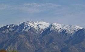 Mt. Ogden from the west | |
| Highest point | |
| Elevation | 9,579 ft (2,920 m) NAVD 88[1] |
| Prominence | 3,810 feet (1,161 m) [2] |
| Coordinates | 41°12′00″N 111°52′55″W / 41.199913961°N 111.882033519°WCoordinates: 41°12′00″N 111°52′55″W / 41.199913961°N 111.882033519°W [1] |
| Geography | |
 Mount Ogden Location in Utah | |
| Location | Weber County, Utah, U.S. |
| Parent range | Wasatch Range |
| Topo map | USGS Ogden |
Mount Ogden is a peak in Weber County, Utah, United States in the northern Wasatch Range.
Mount Ogden has an elevation of 9,579 feet (2,920 m). The peak is popular with hikers, particularly in its three main canyons: Beus, Waterfall, and Taylor Canyons. The mountain’s east face has some good technical crack and face climbing routes. The summit accommodates several large radio towers and a helipad.
Mount Ogden is home to Snowbasin ski resort, where the 2002 Olympics downhill ski races were held.
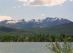
Mount Ogden from the east, with Pineview Reservoir in the foreground
References
- 1 2 "Ogden Peak". NGS data sheet. U.S. National Geodetic Survey. Retrieved 2016-04-22.
- ↑ "Mount Ogden, Utah". Peakbagger.com. Retrieved 2016-04-22.
External links
![]() Media related to Mount Ogden at Wikimedia Commons
Media related to Mount Ogden at Wikimedia Commons
- "Mount Ogden". Geographic Names Information System. United States Geological Survey.
- "Mount Ogden". SummitPost.org.
This article is issued from Wikipedia - version of the 12/2/2016. The text is available under the Creative Commons Attribution/Share Alike but additional terms may apply for the media files.