Mount Oberlin
| Mount Oberlin | |
|---|---|
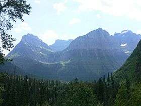 Mount Oberlin at left towers over Bird Woman Falls | |
| Highest point | |
| Elevation | 8,180 ft (2,490 m) [1] |
| Prominence | 660 ft (200 m) [1] |
| Coordinates | 48°42′16″N 113°44′09″W / 48.70444°N 113.73583°WCoordinates: 48°42′16″N 113°44′09″W / 48.70444°N 113.73583°W [2] |
| Geography | |
| Location | Flathead County, Montana, U.S. |
| Parent range | Lewis Range |
| Topo map | USGS Logan Pass, MT |
Mount Oberlin (8,180 feet (2,493 m)) is located in the Lewis Range, Glacier National Park in the U.S. state of Montana.[3] Mount Oberlin is just northwest of Logan Pass. Below the summit to the northwest, water and melting snow off Mount Oberlin lead to the 492 feet (150 m) Bird Woman Falls, one of the tallest waterfalls in Glacier National Park.
Dr. Lyman B. Sperry, a member of an 1895 party exploring the Glacier Park region, named the mountain after his employer, Oberlin College.[4][5]
See also
References
- 1 2 "Mount Oberlin, Montana". Peakbagger.com. Retrieved 2010-08-22.
- ↑ "Mount Oberlin". Geographic Names Information System. United States Geological Survey. Retrieved 2010-08-22.
- ↑ "Mount Oberlin, Montana" (Map). TopoQuest (USGS Quad). Retrieved 2010-08-22.
- ↑ "Through The Years In Glacier National Park: An Administrative History (Appendix A)". National Park Service. Retrieved 2013-06-15.
- ↑ "Discovery and Exploration". National Park Service. Archived from the original on February 23, 2006. Retrieved 2007-01-12.
This article is issued from Wikipedia - version of the 4/3/2016. The text is available under the Creative Commons Attribution/Share Alike but additional terms may apply for the media files.