Mount Morgan (Mono County, California)
Not to be confused with Mount Morgan (Inyo County, California) located 9 miles (14 km) to the south southwest..
| Mount Morgan | |
|---|---|
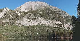 Mount Morgan from Davis Lake | |
| Highest point | |
| Elevation | 12,998+ ft (3,962+ m) NAVD 88[1] |
| Prominence | 1,472 ft (449 m) [1] |
| Listing | Sierra Peaks Section[2] |
| Coordinates | 37°30′41″N 118°46′47″W / 37.5113223°N 118.7798486°WCoordinates: 37°30′41″N 118°46′47″W / 37.5113223°N 118.7798486°W [3] |
| Geography | |
| Location | Mono County, California, U.S. |
| Parent range | Sierra Nevada |
| Topo map | USGS Convict Lake |
| Climbing | |
| First ascent | 1934 by David Brower and Norman Clyde[4] |
| Easiest route | Hike, arduous class 1[4] |
Mount Morgan is a highest point on Nevahbe Ridge in the Sherwin Range of the Sierra Nevada. It lies in Mono County, California, between McGee Canyon and Hilton Lakes. The mountain is in the John Muir Wilderness Area in the Inyo National Forest.
References
- 1 2 "Mount Morgan, California". Peakbagger.com. Retrieved 2014-01-19.
- ↑ "Sierra Peaks Section List" (PDF). Angeles Chapter, Sierra Club. Retrieved 2014-01-19.
- ↑ "Mount Morgan". Geographic Names Information System. United States Geological Survey.
- 1 2 Roper, Steve (1976). The Climber's Guide to the High Sierra. San Francisco: Sierra Club Books. pp. 133, 340. ISBN 9780871561473.
External links
- "Mount Morgan (N)". SummitPost.org.
This article is issued from Wikipedia - version of the 3/23/2016. The text is available under the Creative Commons Attribution/Share Alike but additional terms may apply for the media files.