Mount Kosciuszko
| Mount Kosciuszko | |
|---|---|
| Jagungal, Jar-gan-gil, Tar-gan-gil, Tackingal[1] | |
|
Mount Kosciuszko summit | |
| Highest point | |
| Elevation | 2,228 m (7,310 ft) [2][3] |
| Prominence | 2,228 m (7,310 ft) [2] |
| Isolation | 1,894.26 km (1,177.04 mi) [2] |
| Listing | |
| Coordinates | 36°27′27″S 148°15′44″E / 36.45750°S 148.26222°ECoordinates: 36°27′27″S 148°15′44″E / 36.45750°S 148.26222°E [4] |
| Geography | |
 Mount Kosciuszko 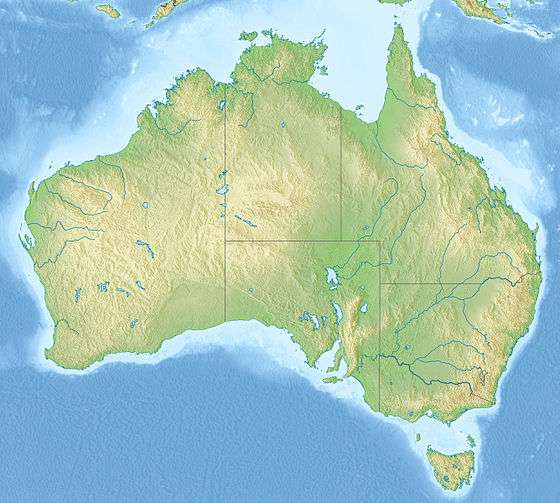 Mount Kosciuszko Location in New South Wales | |
| Location | Snowy Mountains, New South Wales, Australia |
| Parent range | Main Range, Great Dividing Range |
| Topo map | Perisher Valley |
| Climbing | |
| First ascent |
1840 by Paweł Edmund Strzelecki (European)[2][4] Ancient Times by Indigenous Australians |
| Easiest route | Walk (dirt road) |

Mount Kosciuszko is a mountain located on the Main Range of the Snowy Mountains in Kosciuszko National Park, part of the Australian Alps National Parks and Reserves, in New South Wales, Australia and is located west of Crackenback and close to Jindabyne.
With a height of 2,228 metres (7,310 ft) above sea level, it is the highest mountain in mainland Australia.[2][3] Various measurements of the peak originally called Kosciuszko showed it to be slightly lower than its neighbour, Mount Townsend. The names of the mountains were swapped by the New South Wales Lands Department in 1892 so that Mount Kosciuszko remains the name of the highest peak of Australia, and Mount Townsend ranks as second.[5] The 1863 picture by Eugene von Guerard hanging in the National Gallery of Australia titled "Northeast view from the northern top of Mount Kosciusko" is actually from Mount Townsend.[6][7]
When considering all of Oceania as a continent, Mount Kosciuszko is overshadowed by Puncak Jaya in Papua, Indonesia, also called Carstensz Pyramid. Different versions of the Seven Summits climbing challenge depend on which is chosen to be the "Australia" peak.[8]
Etymology
It was named by the Polish explorer Paul Edmund Strzelecki in 1840, in honour of the Polish national hero, General Tadeusz Kościuszko,[note 1] because of its perceived resemblance to the Kościuszko Mound in Kraków.[9]
The name of the mountain was previously spelt "Mount Kosciusko", an Anglicisation, but the spelling "Mount Kosciuszko" was officially adopted in 1997 by the Geographical Names Board of New South Wales.[4] The traditional English pronunciation of Kosciuszko is /kɒziːˈʌskoʊ/, but the pronunciation /kɒˈʃʊʃkoʊ/ is now sometimes used,[10] which is substantially closer to the Polish pronunciation [kɔɕˈt͡ɕuʂkɔ].
There are several native Aboriginal (Ngarigo) names associated with the mountain, with some confusion as to the exact sounds. These are Jagungal, Jar-gan-gil, Tar-gan-gil, Tackingal; however, all of them mean "Table Top Mountain."[1]
Reaching the summit
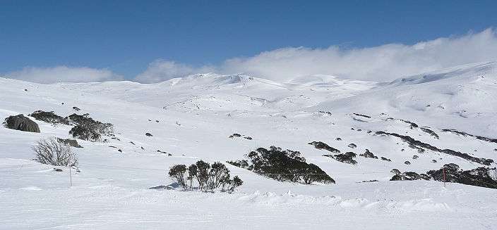
Mount Kosciuszko is the highest summit in mainland Australia. There is a road to Charlotte Pass, from which an 8-kilometre (5 mi) path leads to the summit. Anyone with a modest level of fitness can walk to the top. Until 1977 it was possible to drive through Rawson Pass to within a few metres of the summit. The walking track to Mount Kosciuszko from Charlotte Pass is in fact that road, which was closed to public motor vehicle access due to environmental concerns. This track is also used by cyclists as far as Rawson Pass, where they must leave their bicycles at a bicycle rack and continue onto the summit track on foot.
The peak may also be approached from Thredbo, which is a shorter 6.5 kilometres (4.0 mi), taking 3 to 3.5 hours for a round trip. This straightforward walk is supported by a chairlift all-year round. From the top of the chairlift there is a raised mesh walkway to protect the native vegetation and prevent erosion.
Both tracks meet at Rawson Pass, at an elevation of 2,100 metres (6,900 ft) above sea level, from where it is about 1.6 kilometres (0.99 mi) to the summit. Australia's highest public toilet was built at this pass in 2007, to cope with the more than 100,000 people visiting the mountain each summer.[11]
The peak and the surrounding areas are snow-covered in winter and spring (usually beginning in June and continuing until October or later). The road from Charlotte Pass is marked by snow poles and provides a guide for cross-country skiers and the track from Thredbo is easily followed until covered by snow in winter.
| ||||||||||||||

Recreation

Kosciuszko National Park is also the location of the downhill ski slopes closest to Canberra and Sydney, containing the Thredbo, Charlotte Pass, and Perisher ski resorts. Mount Kosciuszko may have been ascended by Indigenous Australians long before the first recorded ascent by Europeans.
Each year in December, an ultramarathon running race called the Coast to Kosciuszko ascends to the top of Mount Kosciuszko after starting at the coast 240 kilometres (150 mi) away. Paul Every, who is credited as being the one who thought of holding such a race, was the inaugural co-winner in 2004.[12]
Higher Australian mountains
Higher peaks exist within territory administered or claimed by Australia, but outside the continent:
- Mawson Peak (2,745 m or 9,006 ft) on Heard Island
- Dome Argus (4,030 m or 13,220 ft), Mount McClintock (3,490 m or 11,450 ft) and Mount Menzies (3,355 m or 11,007 ft) in the Australian Antarctic Territory.
Higher peaks in the region, but outside the mainland continent:
- Puncak Jaya (4,884 m or 16,024 ft) in New Guinea. It is the highest island mountain in the world, the highest mountain in Indonesia and the highest in the Australian continent and Oceania.
- Puncak Mandala (4,760 m or 15,620 ft) in the Papua province of Indonesia. It is the second highest mountain of the Australian continent, Oceania, Australasia, New Guinea and Indonesia.
- Puncak Trikora (4,750 m or 15,580 ft) in the Papua province of Indonesia.
- Mount Wilhelm (4,509 m or 14,793 ft) in Papua New Guinea. It is the highest mountain in that country.
- Mount Victoria (4,072 m or 13,360 ft) in Central Province, Papua New Guinea.
- Mount Giluwe (4,368 m or 14,331 ft) a volcanic mountain in Papua New Guinea. It is the highest volcanic summit in the Australian continent.
In popular culture
Australian rock band Midnight Oil performed a song called "Kosciusko" on its 1984 album Red Sails in the Sunset, referring to the mountain. The spelling was updated to "Kosciuszko" for the group's 1997 compilation album, 20,000 Watt R.S.L.
Gallery
 Mount Kosciuszko from south side
 Mount Etheridge from south side showing high elevation toilet at Rawson Pass
 East side of the mountain
 The plate at the top
 The base of a survey trig marker at the top
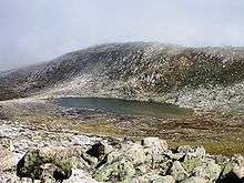 Lake Cootapatamba, the lake on the highest place in the Australian continent
 A view from the track to Mount Kosciuszko
 Thredbo from the Australian Alps Walking Track.
 View of Mount Kosciuszko and the Etheridge Range from the headwaters of the Snowy River
See also
Notes
- ↑ Kościuszko was also a national hero in Lithuania, and Belarus, and hero of the American Revolutionary War
References
- 1 2 "James M. Spencer, THE HIGHEST POINT IN AUSTRALIA.". The Sydney Morning Herald. National Library of Australia. 18 February 1885. p. 7. Retrieved 22 February 2014.; cited in Alan E.J. Andrews, Kosciusko: The Mountain in History, O'Connor, A.C.T, Tabletop Press, 1991, p.50.
- 1 2 3 4 5 "Mount Kosciuszko, Australia". Peakbagger.com. Retrieved 28 May 2015.
- 1 2 "Kosciuszko National Park". Australian Alps National Parks. Australian Government. Retrieved 13 June 2009.
- 1 2 3 "Mount Kosciuszko". Geographical Names Register (GNR) of NSW. Geographical Names Board of New South Wales. Retrieved 27 May 2015.
- ↑ "Mountain systems of Australia". Year Book Australia, 1901-1909. Australian Bureau of Statistics.
- ↑ "Eugene von Guérard: North-east view from the northern top of Mount Kosciusko 1863". National Gallery of Australia. Archived from the original on 4 November 2008.
- ↑ http://www.jokar.com.au/projects/Ten-Mile%20Stare/slides/Mt_Townsend_Panorama1.html
- ↑ "Facts & figures of all 7summiteers!". Retrieved 19 August 2013.
- ↑ "Australian Geographical Name Derivations". Wikiski.com. 8 April 2011. Retrieved 18 June 2012.
- ↑ Yallop, Colin, ed. (2005). Macquarie Dictionary (4th ed.). Melbourne: The Macquarie Library. ISBN 1-876429-14-3.
- ↑ "The rush to complete Australia's highest dunny" (PDF). Department of Environment and Climate Change, NSW. 3 May 2007. pp. 6–7.
- ↑ "Coast to Kosciuszko". Coast2kosci.com. Retrieved 18 June 2012.
13. http://mtkosciuszko.org.au/english/strzelecki-kosciuszko.htm Webpage of proper name explanations
External links
| Wikisource has the text of the 1911 Encyclopædia Britannica article Kosciusco. |
| Wikimedia Commons has media related to Mount Kosciuszko. |
- Mt Kosciuszko Inc. — page for information about explorer P.E Strzelecki – and news about Mount Kosciuszko
- Peakware – World Mountain Encyclopaedia — photo
- Hiking Mount Kosciuszko
|  | |
| ||
| Townships and Villages | |
|---|---|
| Localities and rural places |
|
| National parks and other natural features | |
| Rivers and other watercourses | |
| Dams and/or associated reservoirs |
|
| Mountain ranges |
|
| Attractions | |
Main Article: Local government areas of New South Wales | |