Mount Kineo
| Mount Kineo | |
|---|---|
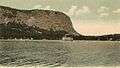
 Mount Kineo in 2009 | |
| Highest point | |
| Elevation | 1,789 ft (545 m) [1] |
| Prominence | 750 ft (230 m) [1][2] |
| Listing | List of mountains of Maine |
| Coordinates | 45°41′59″N 69°44′02″W / 45.69972°N 69.73389°WCoordinates: 45°41′59″N 69°44′02″W / 45.69972°N 69.73389°W [3] |
| Geography | |
 Mount Kineo Piscataquis County, Maine, U.S. | |
| Topo map | USGS Mount Kineo |
Mount Kineo, situated beside Moosehead Lake in Maine, is in the northern Maine forest, which stretches north to Canada. Kineo is a peninsula, comprising 1,150 acres (4.7 km²), which extends from the easterly shore into the lake. Mt. Kineo, with 700-foot (210 m) cliffs rising straight up from the water, is a dramatic setting that has attracted visitors for centuries.
Native Americans once traveled great distances to Mt. Kineo to acquire its rhyolite rock. The mountain is said to contain one of the largest formations of rhyolite in the world. This rhyolite is evidence of an igneous (volcanic) phase although the mountain formation also contain slate and sandstone demonstrating sedimentary and metaphoric history as well. The mechanical properties of the rhyolite on Mount Kineo exhibits the physical properties of flint and was used extensively by indigenous peoples to make arrowheads and implements and thus, has often been referred to as "Kineo flint" in literature; but this term misleads by implication that the rhyolite is a cryptocrystalline form of the mineral quartz derived from a sedimentary origin. The rhyolite is actually an igneous extrusive material implying a volcanic phase that created the unique properties of this highly sought after material. Being the country's largest known mass of this rock, once used by Indians to craft arrowheads, hatchets, chisels, etc., Indian implements made from the stone have been found in all parts of New England and even further south, it is evident that various tribes visited Mt. Kineo for centuries to obtain this material.[4]
In 1846, Henry David Thoreau visited the Moosehead Lake region, and the mountain's geological formation, Indian relics and traditions deeply interested him. The first Mt. Kineo House was built on the shores of Moosehead Lake in 1848, but burned in 1868. Rebuilt in 1870 and opened in 1871, the second Mt. Kineo House would burn in 1882. Designed by Arthur H. Vinal, the third Mt. Kineo House opened in 1884. Mt. Kineo Golf Course, built in the 1880s, is believed to be the second oldest in New England.[5]
In 1911, the Maine Central Railroad purchased the resort and engaged the Hiram Ricker Hotel Company to operate it. Then the largest inland waterfront hotel in America, it had accommodations for over 500 guests. But in 1933, the railroad eliminated its Kineo branch, and in 1938 sold the hotel. It burned during demolition and today the old employee house still stands next to hole # 9 of the golf course.[5]
Under new ownership since 2009, the golf course has been upgraded every year. New tee-off areas, better green management and an updated club house are among the new features. Played on the original 1893 course it is a classic lake side layout with no sand traps and small greens. With the Kineo cliff as a back-drop; the over-the-water par 3 hole #4 is one of the most scenic golf holes anywhere.
The Golf Club also operates the seasonal water shuttle service from the public dock in Rockwood to Mount Kineo.
 Steamer arriving at Mt. Kineo in 1906
 The Mt. Kineo House in 1908
References
- 1 2 "Mount Kineo". Peakbagger.com. Retrieved 2009-08-22.
- ↑ Key col elevation between 1030 and 1040 feet.
- ↑ "Mount Kineo". Geographic Names Information System. United States Geological Survey. Retrieved 2009-05-03.
- ↑ "History of Mount Kineo". Moosehead Historical Society. Retrieved 2010-11-19.
- 1 2 "History of The Mount Kineo House". baharris.org. Retrieved 2010-11-19.