Ipf (mountain)
| Ipf | |
|---|---|
|
Ipf | |
| Highest point | |
| Elevation | 668 m (2,192 ft) |
| Coordinates | 48°52′14″N 10°21′23″E / 48.87056°N 10.35639°ECoordinates: 48°52′14″N 10°21′23″E / 48.87056°N 10.35639°E |
| Geography | |
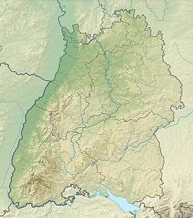 Ipf Location within Baden-Württemberg | |
| Location | Baden-Württemberg, Germany |
| Parent range | Swabian Jura |

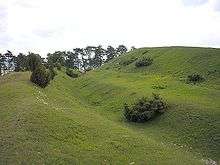
Prehistoric wall on the northern hillside

This aerial image shows the extensive fortification on the Ipf
The Ipf is a mostly treeless mountain (668 metres), near Bopfingen, Ostalbkreis, Baden-Württemberg, Germany with a prehistoric hill fort on its top.
The fort is situated on an isolated hill, with a flattened summit surrounded by a stone wall, ditch and large counterscarp (outer bank). The overall diameter is about 180 metres. There are also extensive ramparts traversing the slopes to protect a large enclosed area and entranceway. There is evidence of occupation from the Bronze Age through the Iron Age to the early Celtic La Tene period, a span of almost a thousand years (1200 BC - 300 BC).[1]
References
- ↑ F. Hertlein: Die vorgeschichtlichen Befestigungen auf dem Ipf. Blätter des Schwäbischen Albvereins, 23. Jg. (1911), Nr. 2, S. 48–55 und Nr. 3, S. 68–74.
This article is issued from Wikipedia - version of the 5/26/2015. The text is available under the Creative Commons Attribution/Share Alike but additional terms may apply for the media files.