Mount Hampton
| Mount Hampton | |
|---|---|
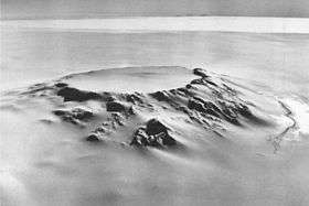 The caldera of Mt. Hampton viewed from the northwest. | |
| Highest point | |
| Elevation | 3,323 m (10,902 ft) |
| Coordinates | 76°29′S 125°48′W / 76.483°S 125.800°WCoordinates: 76°29′S 125°48′W / 76.483°S 125.800°W |
| Geography | |
| Location | Marie Byrd Land, Antarctica |
| Parent range | Executive Committee Range |
| Geology | |
| Mountain type | Shield volcano |
Mount Hampton is a shield volcano with a circular ice-filled crater occupying much of the summit area. It is the northernmost of the volcanoes which comprise the Executive Committee Range in Marie Byrd Land, Antarctica.
Discovered by the USAS on a flight, December 15, 1940, and named for Ruth Hampton, Dept. of the Interior member of the USAS Executive Committee. Mapped in detail by USGS from surveys and U.S. Navy trimetrogon photography, 1958-60.

Topographic map of Mount Hampton (1:250,000 scale) from USGS Mount Hampton
See also
Sources
- LeMasurier, W. E.; Thomson, J. W., eds. (1990). Volcanoes of the Antarctic Plate and Southern Oceans. American Geophysical Union. p. 512 pp. ISBN 0-87590-172-7.
- U.S. Geological Survey Geographic Names Information System: Mount Hampton
- "Skiing the Pacific Ring of Fire and Beyond". Amar Andalkar's Ski Mountaineering and Climbing Site. 2007 [1997]. Retrieved 2005-01-14.
This article is issued from Wikipedia - version of the 11/11/2016. The text is available under the Creative Commons Attribution/Share Alike but additional terms may apply for the media files.