Mount Gibbs
| Mount Gibbs | |
|---|---|
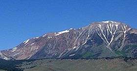 Mount Gibbs, June 2004 | |
| Highest point | |
| Elevation | 12,779 ft (3,895 m) NAVD 88[1] |
| Prominence | 1,093 ft (333 m) [1] |
| Parent peak | Mount Dana[2] |
| Listing |
|
| Coordinates | 37°52′38″N 119°12′43″W / 37.8771495°N 119.2118164°WCoordinates: 37°52′38″N 119°12′43″W / 37.8771495°N 119.2118164°W [5] |
| Geography | |
 Mount Gibbs  Mount Gibbs
| |
| Location | Mono and Tuolumne counties, California, U.S. |
| Parent range | Sierra Nevada |
| Topo map | USGS Mount Dana |
| Geology | |
| Age of rock | Cretaceous |
| Mountain type | Metamorphic rock |
| Climbing | |
| First ascent | 1864 by Frederick Law Olmsted and William Henry Brewer on horseback[6] |
| Easiest route | Cross-country hike, class 1[6] |
Mount Gibbs is located in the Sierra Nevada of the U.S. state of California, 2.6 miles (4 km) south of Mount Dana. The mountain was named in honor of Oliver Gibbs, a professor at Harvard University and friend of Josiah Whitney.[7] The summit marks the boundary between Yosemite National Park and the Ansel Adams Wilderness.
The peak is accessible either from the west, starting at Tioga Pass Road, or from the east, via Bloody Canyon from the trailhead at Walker Lake. Overnight camping is not permitted on the western side of the mountain, which is part of the protected watershed of Dana Meadows and Tioga Pass. In the summer the mountain has only patchy snow, on the northern slope. The easiest ascent is via the ridge extending west from the peak; there is a steep section of loose, unstable rock, leading to the gentle ridge that forms the top of the mountain. Although the top is above the tree line, there is some sparse plant life, including wildflowers. The view of Mono Lake from the summit is partially obstructed by an outcropping to the northeast.
References
- 1 2 "Mount Gibbs, California". Peakbagger.com. Retrieved 2008-11-26.
- ↑ "Mount Gibbs". ListsOfJohn.com. Retrieved 2011-06-15.
- ↑ "Sierra Peaks Section List" (PDF). Angeles Chapter, Sierra Club. Retrieved 2009-08-10.
- ↑ "Western States Climbers List". Climber.org. Retrieved 2016-03-27.
- ↑ "Mount Gibbs". Geographic Names Information System. United States Geological Survey. Retrieved 2008-11-26.
- 1 2 Secor, R.J. (2009). The High Sierra Peaks, Passes, and Trails (3rd ed.). Seattle: The Mountaineers. p. 397. ISBN 9780898869712.
- ↑ Farquhar, Francis P. (1926). Place Names of the High Sierra. San Francisco: Sierra Club. Retrieved 2008-11-26.
External links
- "Mount Gibbs". SummitPost.org.