Mount Edgcumbe Country Park
Coordinates: 50°21′11″N 4°11′02″W / 50.353°N 4.184°W

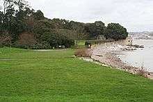
Mount Edgcumbe Country Park ![]() is listed as grade one on the National Register of Historic Parks and Gardens and is one of four designated country parks in Cornwall, United Kingdom.[1] The 885 acres (3.58 km2) country park is on the Rame Peninsula, overlooking Plymouth Sound and the River Tamar. The park has been famous since the 18th century, when the Edgcumbe family created formal gardens, temples, follies and woodlands around the Tudor house. Specimen trees such as Sequoiadendron giganteum,[2] stand against copses which shelter a herd of wild fallow deer. The South West Coast Path runs through the park for nine miles (14 km) along the coastline.
is listed as grade one on the National Register of Historic Parks and Gardens and is one of four designated country parks in Cornwall, United Kingdom.[1] The 885 acres (3.58 km2) country park is on the Rame Peninsula, overlooking Plymouth Sound and the River Tamar. The park has been famous since the 18th century, when the Edgcumbe family created formal gardens, temples, follies and woodlands around the Tudor house. Specimen trees such as Sequoiadendron giganteum,[2] stand against copses which shelter a herd of wild fallow deer. The South West Coast Path runs through the park for nine miles (14 km) along the coastline.
The park also contains the villages of Kingsand and Cawsand, as well as Mount Edgcumbe House itself. The Formal Gardens are grouped in the lower park near Cremyll. Originally a 17th-century 'wilderness' garden, the present scheme was laid out by the Edgcumbe family in the 18th century. The Formal Gardens include an Orangery, an Italian Garden, a French Garden, an English Garden and a Jubilee Garden, which opened in 2002, to celebrate the Queen's Golden Jubilee. The park and Formal Gardens are open all year round and admission is free. The park and gardens are jointly managed by Cornwall Council and Plymouth City Council. Although the park covers a large area, the park has limited formal maintenance. This gives it a rough and ready rural feel in all except the Formal Gardens.
Features of the park
The park is well endowed with interesting features, many of which are Grade II or Grade II* listed.
- Barn Pool
A sheltered deep water basin anchorage used by the Vikings in 997. Offshore there is a shipwreck of the Catharina von Flensburg. On 27 December 1831, HMS Beagle set off from here on her second survey voyage, captained by Robert FitzRoy with Charles Darwin on board.[3]
- Barrow
c.1200 BC - a Bronze Age burial mound, re-used as a "Prospect Mound" in the 18th century.
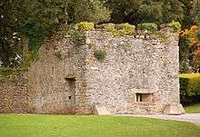
c.1545 - a small fort built on the shoreline in King Henry VIII's reign, to defend the mouth of the Tamar and the Edgcumbes' town of West Stonehouse opposite. [4]
- Coastguard Station at Rame Head
Originally a Lloyd's Signal Station, where signalling was done from passing ships to the station by flags during the day and by lights at night, it became a radio station in 1905, then transferred to the Coastguards c.1925.
- Cremyll Ferry
c.1204 - a major ferry crossing between Devon and Cornwall since medieval times.
- Deer
In 1515 Sir Piers Edgcumbe was given permission by King Henry VIII to empark deer: the deer of today roam freely on the Rame Peninsula.
- Deer Wall or Ha Ha
c.1695 - A stone wall with outer ditch to protect the Amphitheatre from deer. [5]
- Earl's Drive
In early days called the Terrace. A driveway from the House round the coast to Maker Church by 1788, extended to Penlee Point by 1823.

1747 - an artificial ruin which replaced a navigation obelisk. It was built from stone from the churches of St. George and St. Lawrence, Stonehouse.[6]
- Formal Gardens
From circa 1750 to 1820 - gardens in Italian, English and French styles. New Zealand, American (1989) and Jubilee Gardens (2003) have now been added.[7]
- Garden Battery
c.1747 and 1863 - an 18th-century saluting platform, originally mounted with 21 guns to greet visitors. Re-built in 1863 as part of Plymouth's Naval defences, with granite casemates for 7 large 68-pounder guns.[8][9]

- Harbour View Seat
18th century - a much damaged ornamental seat also known as White Seat, with a magnificent view north up the River Tamar. [10]
- Upper Deer House and Pebble Seat
19th century - in the Grotton Plantation the ruins of a two storey fodder store for deer; and the ruined 18th century Pebble Seat facing south.[11][12]
From around 1800, this ice house is under the bridge leading to the House. It is only open on special occasions.[13]
- Maker Church
First mentioned in 1186, it was enlarged in the 15th century. This is the family church of the Edgcumbes.

- Milton's Temple
A circular temple from 1755, with a plaque inscribed with lines from Paradise Lost; overhead up grew, insuperable heights of loftiest shade...... [14]
The Orangery in the Italian Garden is thought to have been built as early as 1760. The building is now a fully licensed restaurant. [15]
1892 - the remains of a Victorian fort armed with 3 guns in both World Wars. A granite sculpture by Greg Powlesland, (1995), is in the nearby nature reserve.
- Picklecombe Fort Seat
A seat made from a doorway and enclosing a small niche with a piscina at the back. The carved stone comes from the churches of St. George and St. Lawrence at Stonehouse. [16]
- Queen Adelaide's Grotto
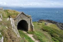
18th century cave used as a watch house, enhanced with an arched stone building after Adelaide's visit, 1827.
Rebuilt from a Norman church in 1239, and enlarged in the 15th century.
- Red Seat
19th century - a ruinous rest house, sometimes called the Kiosk, which was painted red. Below is another ruined seat known as Indian Cottage or The Verandah. [17]
c.1850 - The stables, dairy, smithy, sawmill and stores, all essential to the running of the estate. The stables are open to the public and house a cafe as well as various activity centres and art studios.[18]
- St. Julian's Well
A very small 15th century chapel and holy well, which was restored c.1890.[19]

14th century - a chapel and simple lighthouse, with a beacon site nearby. Across the neck of the headland are the earthworks of an Iron Age fort.
This goes around the Country Park.
From around 1760, a Doric pavilion with seats looking across to Plymouth Sound. Verses from Thomson's "The Seasons" are inscribed on the wall. [20]
- West Lodge and Arch
The Arch over the Earl's Drive may have been built to mark the creation of the Viscount in 1781.[21]
The Zig-Zag walks were from the 1760s, and became famous in the 19th century as The Horrors. Intricate paths on a dramatic cliff, surrounded by exotic shrubs. The lower cliff paths and some stone seats have been lost to cliff erosion.
Wildlife and ecology
Several larvae of the Beautiful Pearl (Agrotera nemoralis), was found by members of the Cornish branch of Butterfly Conservation on European hornbeam (Carpinus betulus) during August, 2013. The micro-moth was previously only known (in Britain) from East Blean Woods, Kent.[22]
See also
References
- ↑ "Mount Edgcumbe". Heritage Gateway. English Heritage. Retrieved 29 January 2015.
- ↑ Thurston, Edgar (1930). British & Foreign Trees and Shrubs in Cornwall. Cambridge: Cambridge University Press.
- ↑ FitzRoy, R. 1839. Narrative, p. 42.
Keynes, R. D. ed. 2001. Charles Darwin's Beagle diary, pp 4–17 - ↑ "Name: TUDOR BLOCK HOUSE List entry Number: 1161267". Historic England. Retrieved 12 July 2015.
- ↑ "Name: HA HA List entry Number: 1140615". Historic England. Retrieved 12 July 2015.
- ↑ "Name: THE FOLLY List entry Number: 1329143". Historic England. Retrieved 12 July 2015.
- ↑ "MOUNT EDGCUMBE List entry Number: 1000134". Historic England. Retrieved 12 July 2015.
- ↑ "Name: GARDEN BATTERY List entry Number: 1329141". Historic England. Retrieved 12 July 2015.
- ↑ http://www.ecastles.co.uk/plymouthcentral.html
- ↑ "Name: THE WHITE SEAT List entry Number: 1140618". Historic England. Retrieved 12 July 2015.
- ↑ "Name: THE UPPER DEER HOUSE List entry Number: 1161325". Historic England. Retrieved 12 July 2015.
- ↑ "THE PEBBLE SEAT List entry Number: 1140626". Historic England. Retrieved 12 July 2015.
- ↑ "Name: DRIVE BRIDGE AND ICE HOUSE, WEST OF MOUNT EDGCUMBE PARK List entry Number: 1140654". Historic England. Retrieved 12 July 2015.
- ↑ "Name: TEMPLE OF MILTON List entry Number: 1140616". Historic England. Retrieved 12 July 2015.
- ↑ "Name: ORANGERY IN THE ITALIAN GARDEN List entry Number: 1329142". Historic England. Retrieved 12 July 2015.
- ↑ "Name: PICKLECOMBE SEAT List entry Number: 1140628". Historic England. Retrieved 12 July 2015.
- ↑ "Name: THE RED SEAT List entry Number: 1310099". Historic England. Retrieved 12 July 2015.
- ↑ "Name: RANGE OF OUTBUILDINGS AND WALL ATTACHED TO REAR OF 1 TO 5 BARROW PARK FLATS List entry Number: 1140653". Historic England. Retrieved 12 July 2015.
- ↑ "Name: ST JULIAN'S WELL List entry Number: 1329144". Historic England. Retrieved 12 July 2015.
- ↑ "Name: THOMSON'S SEAT List entry Number: 1161293". Historic England. Retrieved 12 July 2015.
- ↑ "Name: THE ARCHWAY OVER THE EARL'S DRIVE List entry Number: 1310044". Historic England. Retrieved 12 July 2015.
- ↑ "Pearls In The Park". Cornwall Butterfly Conservation. Butterfly Conservation. Retrieved 29 January 2015.
External links
- Official Website
- Mount Edgcumbe photo gallery
- Old photos of Mount Edgcumbe
- Village Holiday Information
- Postcards of Mount Edgcumbe
Cornwall Portal | |
| Unitary authorities | |
| Major settlements |
|
| Rivers | |
| Topics | |