Mount Clare (Maryland)
|
Mount Clare | |
|
Mount Clare, December 2011 | |
   | |
| Location | Carroll Park, Baltimore, Maryland |
|---|---|
| Coordinates | 39°16′44″N 76°38′37″W / 39.27889°N 76.64361°WCoordinates: 39°16′44″N 76°38′37″W / 39.27889°N 76.64361°W |
| Area | 0 acres (0 ha) |
| Built | 1763 |
| Architect | Unknown |
| Architectural style | Georgian |
| NRHP Reference # | 70000860 |
| Significant dates | |
| Added to NRHP | April 15, 1970[1] |
| Designated NHL | April 15, 1970[2] |
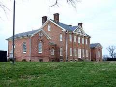
"Mount Clare" — also known as "Mount Clare Mansion", known today as the Mount Clare Museum House — is the oldest Colonial-era structure in the City of Baltimore, Maryland, U.S.A. The Georgian style of architecture plantation house exhibits a somewhat altered five-part plan.[3] It was built on a Carroll family plantation beginning in 1763 by barrister Charles Carroll the Barrister, (1723-1783), a descendant of the last Gaelic Lords of Éile in Ireland and a distant relative of Charles Carroll of Carrollton, (1737-1832), longest living signer of the Declaration of Independence and the richest man in America in his later years, also the layer of the "first stone" of the new Baltimore and Ohio Railroad, just a short distance away in 1828.
The City of Baltimore purchased a large portion of the former estate in 1890 as its third large landscaped park.[4] Mount Clare has been maintained by the National Society of Colonial Dames in Maryland, the local chapter of The National Society of The Colonial Dames of America, since 1917. In 1970, it was added to the National Register of Historic Places and designated a National Historic Landmark.
Description
"Mount Clare" features a portico on the front facade with a projecting bay above. The upper bay contains a Palladian window.
The City of Baltimore built Palladian pavilions connected by hyphens on either side in 1910 as a concealed public toilets structure,[5] but these do not reflect historical construction that were originally on the estate.[4] They have since been converted to a library and a colonial-era kitchen exhibit.[5] A circa 1912 stable, once used to house the Baltimore City Department of Recreation and Parks' Park Ranger horses, is restored and now used for classroom space as well as a rental facility for-events and meetings.
History
The first building on the "Mount Clare" property was built by John Henry Carroll, barrister Charles Carroll's brother, (1723-1783), in 1754, and was probably eventually incorporated as a portion of the larger house. Charles inherited the property originally named "Georgia Plantation" which overlooked the northwestern shore of "Ridgely's Cove of the Middle Branch and Ferry Branch of the Patapsco River where some wharves and docks existed along with a small iron-making foundry after brother John's death and began construction between 1757 and 1760 (unfortunately mistakenly listed for years on museum brochures and tourist information as 1754).
This area had originally been near the first selected site by the appointed Town Commissioners for the new "Baltimore Town" on the site to be laid out in 1729. A different location, further northeast on "The Basin", head of the Northwest Branch of the Patapsco River was chosen after the landowner John Moale objected to the project on the theory that he had located important iron ore deposits there that he intended to eventually mine and exploit. One hundred and twenty years earlier, during the first explorations and mapping by the famed Captain John Smith, (1580-1631), of the northern Chesapeake Bay, on his 1608 map he had labeled what is now called the "Patapsco River" as "Bolus" river, from the Latin, meaning red soil, usually holding iron mineral deposits.
Charles Carroll the Barrister, (1723-1783), began building the present 2-1/2 story Georgian style central block, incorporating his brother John's kitchen and flanking it with a wash house and an orangery. In 1768, Charles added the projecting bay and Palladian window that dominate the entry facade today. The kitchen wing was enlarged and an office wing was added for balance, resulting in a symmetrical nine-part elevation.[6] The house was completed about 1767.[5]
After Barrister Charles' death in 1783, his widow made further changes, connecting the outbuildings and adding a greenhouse to the orangery and expanding the laundry, resulting in a complex about 360 feet long. These additions, along with other alterations, were in the more current style of Federal architecture which is similar to but slightly different from the older Georgian.[6]
By the 1820s, nearby to the east as the street grid of the city began growing and inching closer towards the southwest with its rows and lines of streets and alleys filled with the dense development of small brick rowhouses of various styles. Under the competitive economic pressure to the City and the Port of Baltimore of the 1825 massive construction project with the opening of the northern Erie Canal, with its quicker and cheaper access from the Great Lakes to New York City and the proposed Chesapeake and Ohio Canal along the Potomac River to the south from Georgetown and Washington, D.C. to the western Appalachian Mountains and Cumberland, Maryland caused a long reaction among leading citizens and leaders of the City. The forming by several businessmen and industrialists, after hearing details of the incredible new transportation technology now being used in Great Britain from several of its leading merchants, the Baltimore and Ohio Railroad Company, was formed in 1827 which included Charles Carroll of Carrollton, (1737-1832), as one of its directors and the important ceremonial position of setting the "First Stone" for the railroad at the end of the big parade, festivities and ceremonies on "Independence Day", July 4, 1828, near the old house.
The soon-to-be-famous foundries, shops, forges and other equipment sheds and shacks would be known as the "Mount Clare Shops" off East Pratt Street near future Arlington Street, where a small "Mount Clare Station" was erected in the early 1830s as one of its first passenger terminals and joined by its landmark B. & O. Roundhouse in 1884, (future site after 1953 of the Railroad Company's new "B. & O. Transportation Museum", later reorganized independently as the "B&O Railroad Museum"), in addition to the main temporary one at the southeast corner of West Pratt and South Charles Streets, near the "Basin's" waterfront piers. The "Mount Clare" name which was also attached to the nearby growing neighborhood in the early 19th Century was also home to an increasing complex of foundries, shops, mechanics, industries and businesses supplying equipment, workmen, contractors and businesses, all revolving around the business of "the road". Famous American industrialists, inventors, manufacturers were attracted to the growing industrial capabilities of the area such as Peter Cooper, (1791-1883), of New York who designed the first steam engine locomotives for the railroad when it quickly shifted from the horse-drawn power used during its first four years and Ross Winans, (1796-1877), who further developed locomotives and various other equipment, (followed by his son Thomas Dekoven Winans, with his Russian contracts and work), two of several others who worked with the Company or as contractors and later established their own businesses or foundries nearby. Hundreds of workers with specialized industrial skills, both citizens and recent foreign immigrants worked in southwest Baltimore and lived nearby in the surrounding streets and communities. Other nearby neighborhoods were: "Poppleton", "Union Square", and "East Baltimore", along with the earlier "Pigtown", (also known by the gentrified 1980's as "Washington Village").
The Mansion left the Carroll Family's ownership in 1840, and the house's flanking hyphen wings were demolished. During the American Civil War, (1861-1865), when Baltimore was occupied beginning in May 1861, by northern state militia and then Regular Army forces which surrounded the city with about a dozen forts, fortifications, camps, trenches, earthen berms, bastions and various other impairments, in addition to many military general hospitals and supply depots. Mount Clare was used as a headquarters by Union Army forces who fortified the site and named it "Camp Carroll", as a series of earthen forts surrounding Baltimore, then making it the second most fortified city in the world at that time, next to Washington, D.C, the Nation's Capital.
After the War, and a period as a "beer garden" (the "Schutzengarten"?) by the German community in Baltimore, the house and adjacent acreage 70 acres (28 ha) facing Washington Boulevard and the Gwynns Falls and Middle Branch of the river were purchased in 1890 by the City of Baltimore as its third large landscaped park for its growing southwestern city residents (joining earlier Druid Hill Park, (1860), Patterson Park (1827), and later Clifton Park, (1895), Riverside Park, Herring Run Park and Gwynns Falls Park (including later addition/purchase of Leakin Park in the 1940s) along with many other smaller parks, playgrounds, athletic fields as the Baltimore City Department of Recreation and Parks was established, reorganized and grew.[5]
Beginning in January 2012, a collaborative operating agreement between the City of Baltimore's Department of Recreation and Parks and the B&O Railroad Museum and The National Society of The Colonial Dames of America (Maryland Chapter) (a descendents/ancestors heritage group - whose local members and citizens have been administering, care-taking and keeping in trust this first historic site in the City since 1917, [27 years after the surrounding estate became a city park], long before any city agencies were organized or professionally capable of such proper care and the modern standards of historic preservation) provides for joint administration of "Mount Clare" by both historical institutions. The B&O Railroad Museum, located approximately one mile northeast of Mount Clare, provides seasonal train rides to and from its "Mount Clare Shops" museum complex for visitors, and has developed tours and exhibits noting the railroad and Civil War heritage emphasis of the mansion site. It is also interesting to note that the soon-to-be-constructed/restored/renovation of the second small passenger station ("Mount Clare Station") to supplement its original, little-known, waterfront first station on West Pratt Street (between South Charles and Light Streets along with an extensive complex of workshops, furnaces, warehouses and foundries to maintain the new growing transportation system a mile to the northeast on the edge of the estate were named the "Mount Clare Shops". The Colonial Dames with their experienced staff, volunteers, docents and historians will be telling the story of the mansion itself and its furnishings/decorations with the colonial lifestyle of both the Carroll family (and several subsequent owners in the 19th Century), their relatives and visitors, with the slaves/servants employed in the house, gardens, and outlying grounds and plantation outside of old Baltimore Town.
Access
The manor house has been appointed with historically relevant furnishings and is open to the public. Guided tours are preceded by an introductory video and include a walk through the entire house, together encompassing about 45 to 60 minutes.
Gallery
.jpg) "Mount Clare" Mansion, October 1958 HABS Photograph
"Mount Clare" Mansion, October 1958 HABS Photograph
References
- ↑ National Park Service (2010-07-09). "National Register Information System". National Register of Historic Places. National Park Service.
- ↑ "Mount Clare". National Historic Landmark summary listing. National Park Service. Retrieved 2008-06-17.
- ↑ "Maryland Historical Trust". National Register of Historic Places: Properties in Baltimore City. Maryland Historical Trust. 2008-06-10.
- 1 2 "Mount Clare". Baltimore:A National Register of Historic Places Travel Itinerary. National Park Service. Retrieved 2009-03-17.
- 1 2 3 4 National Historic Landmark Nomination: Mount Clare (pdf). National Park Service. December 19, 1969.
- 1 2 Dorsey, John; Dilts, James D. (1981). A Guide to Baltimore Architecture (Second ed.). Centreville, Maryland: Tidewater Publishes. pp. 140–142. ISBN 0-87033-272-4.
External links
- Mount Clare Museum House - official site
- Mount Clare, National Park Service, Baltimore:A National Register of Historic Places Travel Itinerary
- Mount Clare, Baltimore City, including undated photo, at the Maryland Historical Trust
- Mount Clare, Bayard & South Monroe Streets, Carroll Park, Baltimore, Independent City, MD: 7 photos, 18 data pages, at Historic American Buildings Survey maintained by the Library of Congress
| Topics |  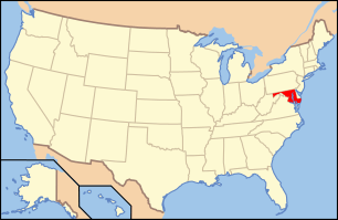 | |
|---|---|---|
| Lists by county | ||
| Lists by city | ||
| Other lists | ||
| ||
museums in Maryland]]