Mount Carleton
| Mount Carleton | |
|---|---|
 | |
| Highest point | |
| Elevation | 820 m (2,690 ft) |
| Listing | |
| Coordinates | 47°23′N 66°53′W / 47.383°N 66.883°WCoordinates: 47°23′N 66°53′W / 47.383°N 66.883°W |
| Geography | |
 Mount Carleton | |
| Parent range | Appalachian Mountains |
| Topo map | NTS 21O/07 |
| Climbing | |
| Easiest route | Hike |

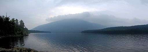
Mount Carleton, in Mount Carleton Provincial Park, is at 817m the highest elevation in the Canadian province of New Brunswick, and is also the highest peak in the Canadian Maritime Provinces. It is one of the highlights of the Canadian portion of the International Appalachian Trail. It is also part of the eighth and final section of the Nepisguit Mi'Gmaq Trail.[1] The mountain was named after Thomas Carleton, New Brunswick's first lieutenant governor,[2][3] and forms part of the Notre Dame Mountains chain, which is visible on Map 24 of the NB Atlas.[4]
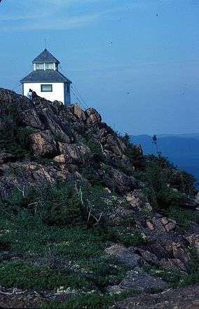
Before aerial surveillance was extensively used, a hut was maintained on the summit for fire-spotting in the remote north-central part of the province. A very similar hut was maintained on Big Bald Mountain. Triangulation among these huts and other fire towers allowed the locations of wildfires to be determined quickly and easily.
Mount Carleton is a monadnock, an erosional remnant of resistant igneous rocks that remained after an ancient Mesozoic peneplain surface was uplifted in the Cenozoic to form a plateau, and subsequently dissected via millions of years of erosion by wind, water and glacial ice.[5][6][7][8] It consists of 400 million-year-old rhyolitic and basaltic volcanics.
See also
- List of highest points of Canadian provinces and territories
- Mountain peaks of Canada
- Mountain peaks of North America
- List of mountains of New Brunswick
References
- ↑ "HISTORY - FRIENDS OF THE NEPISIGUIT MI'GMAQ TRAIL". Retrieved 2015-09-23.
- ↑ Rayburn, A. (1975) Geographical Names of New Brunswick. Toponymy Study 2. Surveys and Mapping Branch, Energy Mines and Resources Canada, Ottawa
- ↑ Geographical Names of Canada http://geonames.nrcan.gc.ca/index_e.php
- ↑ snb.ca: "NB Atlas, Second Edition (Revised 2002)"
- ↑ Wilson, R. A., M. A. Parkhill, and J. I. Carroll, New Brunswick Appalachian Transect: Bedrock and Quaternary geology of the Mount Carleton - Restigouche River Area, http://www.gnb.ca/0078/minerals/pdf/FieldG_Bdrk_Quatern_Geo_NE_NB-e.pdf
- ↑ Roland, A. E. 1982. Geological Background and Physiography of Nova Scotia. Halifax: The Nova Scotian Institute of Science.
- ↑ Encyclopaedia Britannica, http://www.britannica.com/eb/topic-388796/article-9053304
- ↑ Mount Carleton Provincial Park Retrieved on 2007-08-18