Mount Ararat
| Mount Ararat | |
|---|---|
|
| |
| Highest point | |
| Elevation |
5,137 m (16,854 ft) See Elevation section |
| Prominence |
3,611 m (11,847 ft) [1] Ranked 48th |
| Isolation | 379 kilometres (235 mi) |
| Parent peak | Mount Damavand[2] |
| Listing |
Country high point Ultra Volcanic Seven Second Summits |
| Coordinates | 39°42.113′N 44°17.899′E / 39.701883°N 44.298317°ECoordinates: 39°42.113′N 44°17.899′E / 39.701883°N 44.298317°E [3] |
| Geography | |
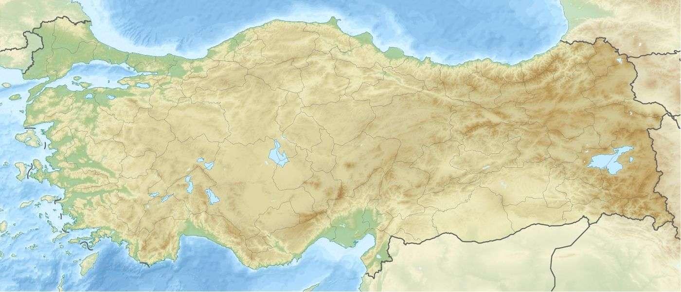 Mount Ararat Location in Turkey | |
| Location | Iğdır Province (65%)[4] and Ağrı Province, Turkey[lower-alpha 1] |
| Parent range | Armenian Highlands |
| Geology | |
| Mountain type | Stratovolcano |
| Last eruption | 1840[6] |
| Climbing | |
| First ascent |
9 October [O.S. 27 September] 1829 Friedrich Parrot, Khachatur Abovian, two Russian soldiers, two Armenian villagers |
.jpg)
| Designations | |
|---|---|
IUCN Category II (National Park) | |
| Official name | Ağrı Dağı Milli Parkı |
| Designated | 1 November 2004[7] |
Mount Ararat (/ˈɑːrəˌrɑːt/ ar-UH-rat;[8] Turkish: Ağrı Dağı; traditional Armenian: Մասիս, Masis) is a snow-capped and dormant compound volcano in the eastern extremity of Turkey.[9] It consists of two major volcanic cones: Greater Ararat, the highest peak in Turkey and the Armenian plateau with an elevation of 5,137 m (16,854 ft); and Little Ararat, with an elevation of 3,896 m (12,782 ft).[10] The Ararat massif is about 40 km (25 mi) in diameter.
Scholars agree the biblical "mountains of Ararat" do not refer to specifically Mt. Ararat. Nevertheless, it has been perceived as the traditional resting place of Noah's Ark since the 11th century. It is the principal national symbol of Armenia and has been considered a sacred mountain by Armenians. It is featured prominently in Armenian literature and art and is an icon for Armenian irredentism. Along with Noah's Ark, it is depicted on the coat of arms of Armenia.
The first efforts to reach Ararat's summit were made in the Middle Ages. However, it was not until 1829 when Friedrich Parrot and Khachatur Abovian, accompanied with four others, made the first recorded ascent.[11]
Political borders
Mount Ararat forms a near-quadripoint between Turkey, Armenia, Azerbaijan and Iran. Its summit is located some 16 km (10 mi) west of both the Iranian border and the border of the Nakhchivan exclave of Azerbaijan, and 32 km (20 mi) south of the Armenian border. The Turkish–Armenian–Azerbaijani and Turkish–Iranian–Azerbaijani tripoints are some 8 km apart, separated by a narrow strip of Turkish territory containing the E99 road which enters Nakhchivan at 39°39′19″N 44°48′12″E / 39.6553°N 44.8034°E.
From the 16th century until 1828 Great Ararat's summit and the northern slopes, along with the eastern slopes of Little Ararat were part of Persia, while the range was part of the Ottoman-Persian border. Following the 1826–28 Russo-Persian War and the Treaty of Turkmenchay, the Persian controlled territory was ceded to the Russian Empire. Little Ararat became the point where the Turkish, Persian, and Russian imperial frontiers converged.[12] The current international boundaries were formed throughout the 20th century. The mountain came under Turkish control during the 1920 Turkish–Armenian War.[13] It formally became part of Turkey according to the 1921 Treaty of Moscow and Treaty of Kars.[14] In the late 1920s, Turkey crossed the Iranian border and occupied the eastern flank of Lesser Ararat as part of its effort to quash the Kurdish Ararat rebellion.[15] The Kurdish rebels were using the area "as a haven against the state in their uprising."[16] Iran eventually agreed to cede the area to Turkey in a territorial exchange.[15][17] The Iran-Turkey boundary skirts east of Lesser Ararat, the lower peak of the Ararat massif.
Names and etymology
.jpg)


Ararat (Hebrew: אֲרָרָט;[18] Armenian: Արարատ) is the Hebrew spelling of Urartu,[19][lower-alpha 2] a kingdom that existed in the Armenian plateau in the 9th-6th centuries BC. The mountain is known as Ararat in European languages.[21][22] However, none of the native peoples have traditionally referred to the mountain by that name.[23]
The traditional Armenian name is Masis (Մասիս [maˈsis]), which is sometimes transliterated as Massis.[24][23] However, nowadays, the terms Masis and Ararat are both widely, often interchangeably, used in Armenian.[25][26] The peaks are referred to in plural as Մասիսներ Masisner.[27] Greater Ararat is known as simply Masis or Մեծ Մասիս (Mets Masis, "Great/Big Masis"). While Lesser Ararat is known as Sis (Սիս)[28][29] or Փոքր Մասիս (P′ok′r Masis, "Little/Small Masis").[21][27] The folk etymology expressed in Movses Khorenatsi's History of Armenia derives the name from king Amasya, the great-grandson of the legendary Armenian patriarch Hayk, who is said to have called the mountain Masis after himself.[30][31] While according to Sebeos it comes from the personal name Marseak.[30] According to Russian orientalist Anatoly Novoseltsev the word Masis derives from Middle Persian masist, "the largest."[32] According to Armenian historian Sargis Petrosyan the mas root in Masis means "mountain", cf. Indo-European *mņs-.[31]
In classical antiquity, particularly in Strabo's Geographica, the peaks of Ararat were known in Greek as Ἄβος (Abos) and Νίβαρος (Nibaros).[lower-alpha 3]
The Turkish name is Ağrı Dağı [ɑːrɯ dɑ.ɯ], Ottoman Turkish: اغـر طﺎﻍ Ağır Dağ), i.e. "Mountain of Ağrı". Ağrı literally translates to "pain" or "sorrow".[21][32][37][38] This name has been known since the late Middle Ages.[32]
The traditional Persian name is کوه نوح, [ˈkuːhe ˈnuːh], Kūh-e Nūḥ,[12] literally the "mountain of Noah".[21][24]
The Kurdish name of the mountain is Çiyayê Agirî[39][40] [t͡ʃɪjaːˈje aːgɪˈriː], which translates to "fiery mountain".[41]
Geography
Mount Ararat is located in the Eastern Anatolia Region of Turkey between Doğubeyazıt and Iğdır, near the border with Iran, Armenia and Nakhchivan exclave of Azerbaijan, between the Aras and Murat rivers.[5] Its summit is located some 16 km (10 mi) west of the Turkey-Iran border and 32 km (20 mi) south of the Turco-Armenian border. The Ararat plain runs along its northwest to western side.
Elevation
An elevation of 5,165 m (16,946 ft) for Mount Ararat is still given by some authorities. However, a number of other sources, such as public domain and verifiable Shuttle Radar Topography Mission (STRM) data[42] and a 2007 GPS measurement[43] show that the alternatively widespread figure of 5,137 m (16,854 ft) is probably more accurate, and that the current elevation may be even lower due to the melting of its snow-covered ice cap. 5,137 m is also supported by numerous topographic maps.[44]

Summit Ice Cap
Mount Ararat has an ice cap on its summit. Since at least about 1957, it has been shrinking. In the late 1950s, Blumenthal[45] observed that there existed 11 outlet glaciers emerging from a summit snow mass that covered about 10 km2 (3.9 sq mi). At that time, it was found that the present glaciers on the summit of Ararat to extend as low as an elevation of 3,900 meters (12,800 ft) on the north-facing slope, and an elevation of 4,200 meters (13,800 ft) on its south-facing slope.[45] Using pre-existing aerial imagery and remote sensing data, Sarıkaya[39][46] and others studied the extent of the ice cap on Mount Ararat between 1976 and 2011. They discovered that this ice cap had shrunk to 8.0 km2 (3.1 sq mi) by 1976 and to 5.7 km2 (2.2 sq mi) by 2011. They calculated that between 1976 and 2011, the ice cap on top of Mount Ararat had lost 29% of its total area at an average rate of ice loss of 0.07 km2 (0.027 sq mi) per year over 35 years. This rate is consistent with the general rates of retreat of other Turkish summit glaciers and ice caps that have been documented by other studies.[46]
Blumenthal[45] estimated that the snow line had been as low as 3,000 meters (9,800 ft) in elevation during the Late Pleistocene. Such a snow line would have created an ice cap of 100 km2 (39 sq mi) in extent. However, he observed a lack of any clear evidence of prehistoric moraines other than those which were close to the 1958 glacier tongues. Blumenthal explained the absence of such moraines by the lack of confining ridges to control glaciers, insufficient debris load in the ice to form moraines, and their burial by later eruptions. Years later, Birman[47] observed on the south-facing slopes a possible moraine that extends at least 300 meters (980 ft) in altitude below the base of the 1958 ice cap at an elevation of 4,200 meters (13,800 ft). He also found two morainal deposits that were created by a Mount Ararat valley glacier of Pleistocene, possibly Wisconsinan (Last Glacial Maximum) age downvalley from Lake Balik Golu. The higher moraine lies at an altitude of about 2,200 meters (7,200 ft) and the lower moraine lies at an altitude of about 1,800 meters (5,900 ft). The lower moraine occurs about 15 kilometers (9.3 mi) downstream from Lake Balik Golu. Both moraines are about 30 meters (98 ft) high. It is suspected that Lake Balik Golu occupies a glacial basin.[47]

Geology
Mount Ararat is a polygenic, compound stratovolcano. Covering an area of 1,100 km2 (420 sq mi), it is the largest volcanic edifice within the region. Along its northwest–southeast trending long axis, Mount Ararat is about 45 kilometers (28 mi) long and is about 30 kilometers (19 mi) long along its short axis. It consists of about 1,150 km3 (280 cu mi) of dacitic and rhyolitic pyroclastic debris and dacitic, rhyolitic, and basaltic lavas.[10]
Mount Ararat consists of two distinct volcanic cones, Greater Ararat and Lesser Ararat (Little Ararat). The western volcanic cone, Greater Ararat, is a steep-sided volcanic cone that is larger and higher than the eastern volcanic cone. Greater Ararat is about 25 kilometers (16 mi) wide at the base and rises about 3 kilometers (1.9 mi) above the adjacent floors of the Iğdir and Doğubeyazıt basins. The eastern volcanic cone, Lesser Ararat, is 3,896 meters (12,782 ft) high and 15 kilometers (9.3 mi) across. These volcanic cones, which lie 13 kilometers (8.1 mi) apart, are separated by a wide north–south-trending crack. This crack is the surface expression of an extensional fault. Numerous parasitic cones and lava domes have been built by flank eruptions along this fault and on the flanks of both of the main volcanic cones.[10]
Mount Ararat lies within a complex, sinistral pull-apart basin that originally was a single, continuous depression. The growth of Mount Ararat partitioned this depression into two smaller basins, the Iğdir and Doğubeyazıt basins. This pull-apart basin is the result of strike-slip movement along two en-echelon fault segments, the Doğubeyazıt–Gürbulak and Iğdir faults, of a sinistral strike–slip fault system. Tension between these faults, not only formed the original pull-apart basin, but created a system of faults, exhibiting a horsetail splay pattern, that control the position of the principal volcanic eruption centers of Mount Ararat and associated linear belt of parasitic volcanic cones. The strike-slip fault system within which Mount Ararat located is the result of north–south convergence and tectonic compression between the Arabian Platform and Laurasia that continued after the Tethys Ocean closed during the Eocene epoch along the Bitlis–Zagros suture.[10][48][49]
Geological history
During the early Eocene and early Miocene, the collision of the Arabian platform with Laurasia closed and eliminated the Tethys Ocean from the area of what is now Anatolia. The closure of these masses of continental crust, collapsed this ocean basin by middle Eocene and resulted in a progressive shallowing of the remnant seas, until the end of the early Miocene. Post-collisional tectonic convergence within the collision zone resulted in the total elimination of the remaining seas from East Anatolia, at the end of early Miocene, crustal shortening and thickening across the collision zone, and uplift of the East Anatolian–Iranian plateau. Accompanying this uplift was extensive deformation by faulting and folding, which resulted in the creation of numerous local basins. The north–south compressional deformation continues today as evidenced by ongoing faulting, volcanism, and seismicity.[10][48][50]
Within Anatolia, regional volcanism started middle-late Miocene. During the late Miocene–Pliocene period, widespread volcanism blanketed the entire East Anatolian–Iranian plateau under thick volcanic rocks. This volcanic activity has continued uninterrupted until historical times. Apparently, it reached a climax during the latest Miocene–Pliocene, 6 to 3 Ma. During the Quaternary, the volcanism became restricted to a few local volcanoes such as Mount Ararat. These volcanoes are typically associated with north–south tensional fractures formed by the continuing the north–south shortening deformation of Anatolia.[10]
In their detailed study and summary of the Quaternary volcanism of Anatolia, Yilmaz[10] and others recognized four phases to the construction of Mount Ararat from volcanic rocks exposed in glacial valleys deeply carved into it flanks. First, they recognized a fissure eruption phase of Plinian-subPlinian fissure eruptions that deposited more than 700 meters (2,300 ft) of pyroclastic rocks and a few basaltic lava flows. These volcanic rocks were erupted from approximately north northwest–south southeast-trending extensional faults and fissures prior to the development of Mount Ararat. Second, a cone-building phase began when the volcanic activity became localized at a point along a fissure. During this phase, the eruption of successive flows of lava up to 150 meters (490 ft) thick and pyroclastic flows of andesite and dacite composition and later eruption of basaltic lava flows, formed the Greater Ararat cone with a low conical profile. Third, during a climatic phase, copious flows of andesitic and basaltic lavas were erupted. During this phase, the current cones of Greater and Lesser Ararat were formed as eruptions along subsidiary fissures and cracks and flank occurred. Finally, the volcanic eruptions at Mount Ararat transitioned into a flank eruption phase during which a major north–south-trending fault offset the two cones developed along with a number of subsidiary fissures and cracks on the volcano's flanks. Along this fault and the subsidiary fissures and cracks, a number of parasitic cones and domes were built by minor eruptions. One subsidiary cone erupted voluminous basalt and andesite lava flows. They flowed across the Doğubeyazıt plain and along the southerly flowing Sarısu River. These lava flows formed black ʻaʻā and pāhoehoe lava flows that contain well preserved lava tubes.[10] The radiometric dating of these lava flows yielded radiometric ages of 0.4, 0.48 and 0.81 Ma.[51] Overall, radiometric ages obtained from the volcanic rocks erupted by Mount Ararat range from 1.5 to 0.02 Ma.[10]
Recent volcanic and seismic activity
The chronology of Holocene volcanic activity associated with Mount Ararat is poorly documented. However, either archaeological excavations, oral history, historical records, or combination of these data provide solid evidence that volcanic eruptions of Mount Ararat occurred in 2500–2400 BC, 550 BC, possibly in 1450 AD and 1783 AD, and definitely in 1840 AD. Archaeological evidence demonstrates that explosive eruptions and pyroclastic flows from the northwest flank of Mount Ararat destroyed and buried at least one Koura–Arax culture settlement and caused numerous fatalities in 2500–2400 BC. Oral histories indicated that a significant eruption of uncertain magitude occurred in 550 BC and minor eruptions of uncertain nature might have occurred in 1450 AD and 1783 AD.[6][49][50][52] According to the interpretation of historical and archaeological data, strong earthquakes not associated with volcanic eruptions also occurred the area of Mount Ararat in 139, 368, 851–893, and 1319 AD. During the 139 AD earthquake, a large landslide that caused many casualties and was similar to the 1840 AD landslide originated from the summit of Mount Ararat.[49][50][53]
1840 eruption
Historical records and oral history document a phreatic eruption and pyroclastic flow from radial fissures on the upper north flank of Mount Ararat and a possibly associated earthquake of magnitude 7.4 that caused severe damage and numerous casualties in 1840 AD. Up to 10,000 people in the Mount Ararart region died in the earthquake, including 1900 villagers in the village of Akhuri (modern Yenidoğan) who were killed by a gigantic landslide and subsequent debris flow. In addition, this combination of landslide and debris flow destroyed the town of Aralik, several villages, and Russian military barracks. It also temporarily dammed the Sevjour River.[6][49][50][52]
Ascents
The 13th century missionary William of Rubruck wrote that "Many have tried to climb it, but none has been able."[54] In response to its first ascent by Parrot and Abovian, one high-ranking Armenian Apostolic Church clergyman commented that to climb the sacred mountain was "to tie the womb of the mother of all mankind in a dragonish mode." By contrast, in the 21st century to climb Ararat is "the most highly valued goal of some of the patriotic pilgrimages that are organized in growing number from Armenia and the Armenian diaspora."[55]
First ascent


The first recorded ascent of the mountain in the modern times took place on 9 October [O.S. 27 September] 1829.[11][56][57][58] The Baltic German naturalist Friedrich Parrot of the University of Dorpat arrived at Etchmiadzin in mid-September 1829, almost two years after Russian capture of Erivan, for the single purpose of exploring Ararat. The prominent Armenian writer Khachatur Abovian, then a deacon and translator at Etchmiadzin, was assigned by Catholicos Yeprem, the head of the Armenian Church, as interpreter and guide.
Parrot and Abovian crossed the Aras River into the district of Surmali and headed to the Armenian village of Akhuri situated on the northern slope of Ararat 1,220 metres (4,000 ft) above sea level. They set up a base camp at the Armenian monastery of St. Hakob some 730 metres (2,400 ft) higher, at an elevation of 1,943 metres (6,375 ft). After two failed attempts, they reached the summit on their third attempt at 3:15 p.m. on October 9, 1829.[56][59] The group included Parrot, Abovian, two Russian soldiers—Aleksei Zdorovenko and Matvei Chalpanov, and two Armenian Akhuri villagers—Hovhannes Aivazian and Murad Poghosian.[60] Parrot measured the elevation at 5,250 metres (17,220 ft) using a mercury barometer. This was not only the first ascent of Ararat, but also the second highest elevation climbed by man up to that date outside of Mount Licancabur in the Chilean Andes. Abovian dug a hole in the ice and erected a wooden cross facing north.[61] Abovian also picked up a chunk of ice from the summit and carried it down with him in a bottle, considering the water holy. On 8 November [O.S. 27 October] 1829, Parrot and Abovian together with the Akhuri hunter Sahak’s brother Hako, acting as a guide climbed up Lesser Ararat.[62]
In 2011, a documentary film on Parrot's expedition to Ararat was produced in Estonia by filmmaker Riho Västrik. It was screened at the Golden Apricot International Film Festival in Yerevan in 2013.[63]
Later notable ascents
| Wikisource has original text related to this article: |
Other early notable climbers of Ararat included Russian climatologist and meteorologist Kozma Spassky-Avtonomov (August 1834), Karl Behrens (1835), German mineralogist and geologist Otto Wilhelm Hermann von Abich (29 July 1845),[64] British politician Henry Danby Seymour (1848).[65] Later in the 19th century, two British scholars on Armenia—James Bryce (1876)[66] and H. F. B. Lynch (1893)[67][68]—climbed the mountain. The first winter climb was by Bozkurt Ergör, the former president of the Turkish Mountaineering Federation, who climbed on 21 February 1970.[69]
Resting place of Noah's Ark
Origins of the tradition
According to the fourth verse of the eighth chapter of the Book of Genesis (Genesis 8:4) following a flood, Noah's Ark landed on the "mountains of Ararat" (Biblical Hebrew: הָרֵי אֲרָרָט, hare ararat;[70] Septuagint: ὄρη τὰ ᾿Αραράτ, óri tá ᾿Ararát).[71] Most historians and Bible scholars agree that "Ararat" is the Hebrew name of Urartu, the geographic predecessor of Armenia and referred to the wider region at the time and not the mountain today known as Ararat.[lower-alpha 4] The phrase is translated as "mountains of Armenia" (montes Armeniae) in the Vulgate, the fourth century Latin translation of the Bible.[75] Nevertheless, Mount Ararat is considered the traditional site of the resting place of the Noah's Ark and most Christians prefer this view "largely because it would have been the first peak to emerge from the receding flood waters."[76] It has therefore been called a biblical mountain.[77][78][79]
_-_topographia_paradisi.jpg)
According to Arnold, Mount Ararat has been associated with the Genesis flood story since the 11-12th centuries.[73] Bailey suggested that the local Armenian population began to identify it as the ark's landing place in the 11-12th centuries.[81] British orientalist F. C. Conybeare in his 1901 review of Friedrich Murad's book on Ararat wrote that the mountain was "a center and focus of pagan myths and cults [...] and it was only in the eleventh century, after these had vanished from the popular mind, that the Armenian theologians ventured to locate on its eternal snows the resting-place of Noah's ark."[82] Fischer[72] and Drs. Lee Spencer and Jean Luc Lienard[83] name the 13th century Franciscan missionary William of Rubruck as the earliest reference for the tradition of Mount Ararat as the landing place of the ark in European literature.[54] The 14th century English traveler John Mandeville is another early[84] author who mentioned Mount Ararat, "where Noah's ship rested, and it is still there."[85]
Prevalence of the legend

Spencer and Lienard wrote in 2005 that Mount Ararat is where the European tradition and most of Western Christianity place the landing of Noah's Ark, and add that the tradition "seems to be well entrenched in the Christian world."[83] Howard F. Vos wrote in the International Standard Bible Encyclopedia that most Christians identify Mt. Ararat with the biblical "mountains of Ararat," despite the fact that six other landing places have been proposed.[76] During his visit to Armenia in 2001 Pope John Paul II declared in his homily in Yerevan's St. Gregory the Illuminator Cathedral: "We are close to Mount Ararat, where tradition says that the Ark of Noah came to rest."[88] Patriarch Kirill of Moscow, the head of the Russian Orthodox Church, also mentioned Mount Ararat as the resting place of Noah's Ark in his speech at the Etchmiadzin Cathedral during his visit to Armenia in 2010.[89]
In his 1722 biblical dictionary French monk Augustin Calmet defines Ararat as "a famous mountain in Armenia, on which the ark is said to have rested, after the deluge."[90] American Christian missionary H. G. O. Dwight wrote in 1856 that "the general opinion of the learned in Europe" is that Noah's Ark rested on Mount Ararat.[91] The 1871 Jamieson-Fausset-Brown Bible Commentary mentions it as the "mountain which tradition points to as the one on which the ark rested."[lower-alpha 5] British historian and politician James Bryce, while admitting that the biblical passage implies that the ark rested upon a "mountain in the district which the Hebrews knew as Ararat, or Armenia", wrote in an 1878 article that the biblical writer must have had Mt. Ararat in mind because it is so "very much higher, more conspicuous, and more majestic than any other summit in Armenia."[66]
Those critical of this view point out that Ararat was the name of the country, not the mountain, at the time when Genesis was written. Arnold wrote in his 2008 Genesis commentary, "The location 'on the mountains' of Ararat indicates not a specific mountain by that name, but rather the mountainous region of the land of Ararat."[19] One 19th century scholar argued that "these peaks do not seem suitable for the purpose."[94]
Searches
Searches for Noah's Ark have traditionally concentrated on Mount Ararat.[76] Augustin Calmet wrote in his 1722 biblical dictionary, "It is affirmed, but without proof, that there are still remains of Noah's ark on the top of this mountain; but M. de Tournefort, who visited this spot, has assured us there was nothing like it; that the top of mount Ararat is inaccessible, both by reason of its great height, and of the snow which perpetually covers it."[90] Despite numerous reports of ark sightings (e.g. Ararat anomaly) and rumors, "no scientific evidence of the ark has emerged."[95] Searches for Noah's Ark are considered by scholars an example of pseudoarchaeology.[96][97] Kenneth Feder writes, "As the flood story itself is unsupported by any archaeological evidence, it is not surprising that there is no archaeological evidence for the existence of an impossibly large boat dating to 5,000 years ago."[98]
Significance among Armenians
Symbolism


Mount Ararat has historically been associated with Armenia,[101] and is widely considered the country's principal national symbol.[102][103][104] It is known as the "holy mountain" of the Armenian people,[99][105][106] largely due to its association with the Biblical flood story.[107] It was the home of the gods in pre-Christian Armenian mythology.[108] With rise of Christianity, the mythology associated with pagan worship of the mountain was lost.[109]
Ararat has been described as Armenia's calling card[110] and the country's main brand.[111] One scholar noted that the image of Ararat is "so ubiquitous in everyday material culture [...] that it would prove quite a feat to spend a day in Yerevan without seeing its pictorial representations framed within a nationalizing discourse."[112] Herbert Lottman noted in 1976 that Mt. Ararat is "almost a required backdrop in paintings and prints" and is "the inevitable trademark on local products" in Armenia.[113] Armenians have "a sense of possession of Ararat in the sense of symbolic cultural property," wrote one ethnographer.[114] A Turkish journalist wrote in Radikal that "for the residents of Armenia, it means much more than a mountain."[115] The titles of at least two books describe Armenians as the "people of Ararat."[116][117]
It was the geographical center of ancient Armenian kingdoms,[118][119][lower-alpha 6] and thus a critical piece of the Armenian homeland.[120] One scholar defined the historic Greater Armenia as "the area about 200 miles in every direction from Mount Ararat."[121] In 19th-century era of romantic nationalism, when an Armenian state did not exist, Mt. Ararat symbolized the historical Armenian nation-state.[122] The First Republic of Armenia, the first modern Armenian state that existed between 1918 and 1920, was sometimes called the Araratian Republic or the Republic of Ararat as it was centered in the Ararat plain.[123][124][125]
Myth of origin
The Genesis flood narrative was linked to the Armenian myth of origin by the early medieval historian Movses Khorenatsi. In his History of Armenia, Khorenatsi wrote that Hayk, the legendary founding father and the name giver of the Armenian people is the son of Torgom, the great-grandson of Japheth, one of Noah's sons.[126] Hayk established the roots of the Armenian nation around Mount Ararat.[127][128] According to Razmik Panossian, this myth of creation "makes Armenia the cradle of all civilisation since Noah's Ark landed on the 'Armenian' mountain of Ararat. […] it connects Armenians to the biblical narrative of human development. […] it makes Mount Ararat the national symbol of all Armenians, and the territory around it the Armenian homeland from time immemorial."[129]
Symbol of genocide and Western Armenia
In the aftermath of the Armenian Genocide of 1915, a large portion of the Armenian homeland, particularly what is now eastern Turkey, was left with little to no Armenian population. Although Ararat was then part of the Russian Empire's Erivan Governorate and was ceded to Turkey by the 1921 Treaty of Kars, it came to represent the loss of Western Armenia (eastern Turkey) in the national consciousness of the Armenians.[lower-alpha 7][131][132] "[I]t looms as a reminder of the tragedy that has dominated Armenian life: Mount Ararat is visible from Armenia, but it belongs to Turkey," wrote one journalist in the Smithsonian magazine.[133] Ari L. Goldman noted in 1988, "In most Armenian homes in the modern diaspora, there are pictures of Mount Ararat, a bittersweet reminder of the homeland and national aspirations."[134] Ararat has become a symbol of Armenian efforts to reclaim its "lost lands", i.e. the areas west of Ararat that are now part of Turkey that had significant Armenian population before the genocide.[135] Adriaans wrote, "In everyday banal irredentism we can see that mount Ararat, indeed, features as a sanctified territory for the Armenians, following in the footsteps of the Ark of Noah, its image providing an imaginary link to a golden past."[136] Stephanie Platz wrote, "Omnipresent, the vision of Ararat rising above Yerevan and its outskirts constantly reminds Armenians of their putative ethnogenesis … and of their exile from Eastern Anatolia after the Armenian genocide of 1915."[137]
Coat of arms of Armenia
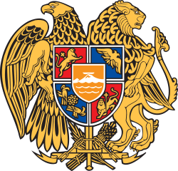
Mount Ararat has been depicted on the coat of arms of Armenia consistently since 1918. The First Republic's coat of arms was designed by architect Alexander Tamanian and painter Hakob Kojoyan. This coat of arms was adopted by the legislature of the Republic of Armenia on April 19, 1992, after Armenia regained independence. Ararat is depicted along with the ark on its peak on the shield on an orange background.[138]
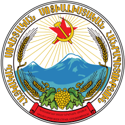
The emblem of the Armenian Soviet Socialist Republic (Soviet Armenia) was created by the painters Martiros Saryan and Hakob Kojoyan in 1921.[139] Mount Ararat is depicted in the center and makes up a large portion of it.[140]
 First Republic (1918–20) |
 Soviet Republic (1921–91) |
 Current Republic (1992–) |
Territorial claims

The nationalist Armenian Revolutionary Federation (Dashnaktsutyun) party claims eastern Turkey (Western Armenia) as part of what it considers United Armenia.[142][143] The Armenian government has not made official claims to any Turkish territory,[144][145] however the Armenian government has avoided "an explicit and formal recognition of the existing Turkish-Armenian border."[146] According to Turkish political scientist Bayram Balci, regular references to the Armenian Genocide and Mount Ararat "clearly indicates" that the border with Turkey in contested in Armenia.[144]
In a 2010 interview with Der Spiegel, Armenian President Serzh Sargsyan was asked: "You can see Mount Ararat, Armenia's national symbol, from the windows of your residence. Today, the mountain is inaccessible, on the other side of the Turkish border. Turkey fears demands for land and compensation. Do you want Mount Ararat back?" Sargsyan, in response, said:[147]
No one can take Mount Ararat from us; we keep it in our hearts. Wherever Armenians live in the world today, you will find a picture of Mount Ararat in their homes. And I feel certain that a time will come when Mount Ararat is no longer a symbol of the separation between our peoples, but an emblem of understanding. But let me make this clear: Never has a representative of Armenia made territorial demands. Turkey alleges this—perhaps out of its own bad conscience?
In various settings, several notable individuals such as German historian Tessa Hofmann,[lower-alpha 8] Slovak conservative politician František Mikloško,[lower-alpha 9] Lithuanian political scientist and Soviet dissident Aleksandras Štromas[lower-alpha 10] have spoken in support of Armenian claims over Mt. Ararat.
Cultural depictions

Ethnographer Levon Abrahamian noted that Ararat is visually present for Armenians in reality (it can be seen from many houses in Yerevan and settlements in the Ararat plain), symbolically (through many visual representations, such as on Armenia's coats of arms), and culturally—in numerous and various nostalgic poetical, political, architectural representation.[152] The first three postage stamps issued by Armenia in 1992 after achieving independence from the Soviet Union depicted Mt. Ararat.[151]
Mount Ararat has been depicted on various Armenian dram banknotes issued in 1993-2001; on the reverse of the 10 dram banknotes issued in 1993, on the reverse of the 50 dram banknotes issued in 1998, on the obverse of the 100 and 500 dram banknotes issued in 1993, and on the reverse of the 50,000 dram banknotes issued in 2001. It was also depicted on the reverse of the Turkish 100 lira banknotes of 1972-1986.[lower-alpha 11]
Ararat is depicted on the logos of two of Armenia's leading universities—the Yerevan State University and the American University of Armenia. It is depicted on the logos of Football Club Ararat Yerevan (since the Soviet times) and the Football Federation of Armenia. The logo of Armavia, Armenia's now defunct flag carrier, also depicted Ararat. The publications of the Social Democrat Hunchakian Party in Lebanon (Ararad daily) and California, U.S. (Massis weekly) are both named for Ararat.
In visual art
European
Ararat was depicted in the books of European, including many British, and American travelers in the 18th-19th centuries who visited Armenia.

 Robert Ker Porter, 1821
 "View of Ararat and the Monastery of Echmiadzin", from the 1846 English translation of Friedrich Parrot's Journey to Ararat
 James Bryce, 1877
 H. F. B. Lynch, 1901
Armenian
According to one source, the first Armenian artist to depict the mountain was Ivan Aivazovsky,[153] who created a painting of Ararat during his visit to Armenia in 1868.[154] Other major Armenians artists who painted Ararat include Yeghishe Tadevosyan, Gevorg Bashinjaghian, Martiros Saryan,[155] and Panos Terlemezian.
.jpg) Ivan Aivazovsky, Valley of Mount Ararat, 1882
Ivan Aivazovsky, Valley of Mount Ararat, 1882 Yeghishe Tadevosyan, Ararat from Ejmiatsin, 1895
 Gevorg Bashinjaghian, 1912
.jpg) Panos Terlemezian, 1929
Panos Terlemezian, 1929
In literature
Rouben Paul Adalian suggested that "there is probably more poetry written about Mount Ararat than any other mountain on earth."[109] Travel writer Rick Antonson described Ararat as the "most fabled mountain in the world."[156]

Non-Armenian
English Romantic poet William Wordsworth imagines seeing the ark[157] in the poem "Sky-Prospect": Lo! in the burning west, the craggy nape/ Of a proud Ararat! and thereupon, / The Ark, her melancholy voyage done![158]
In his Journey to Arzrum (Путешествие в Арзрум; 1835–36), which is about his travels to the Caucasus and Armenia at the time of the Russo-Turkish War (1828–29), the prominent Russian poet Aleksandr Pushkin wrote of Mt. Ararat, "Avidly I looked at the Biblical mountain, saw the ark moored to its peak with the hope of regeneration and life, saw both the raven and dove, flying forth, the symbols of punishment and reconciliation..."[159]
Russian Symbolist poet Valery Bryusov often referred to Ararat in his poetry and dedicated two poems to the mountain,[lower-alpha 12] which were published in 1917. For Bryusov, Ararat is the embodiment of antiquity of the Armenian people and their culture.[160]
In The Maximus Poems American poet Charles Olson, who grew up near the Armenian neighborhood in Worcester, Massachusetts, compares the Ararat Hill near his childhood home to the mountain and "imagines he can capture an Armenian's immigrant perspective: the view of Ararat Hill as Mount Ararat."[161]
Armenian
Mt. Ararat is featured prominently in Armenian literature. According to Meliné Karakashian, Armenian poets "attribute to it symbolic meanings of unity, freedom, and independence."[162] According to Bardakjian, Ararat "epitomizes Armenia and Armenian suffering and aspirations, especially the consequences of the 1915 genocide: almost total annihilation, loss of a unique culture and land [...] and an implicit determination never to recognize the new political borders."[163]
The last two lines of Yeghishe Charents's 1920 poem "I Love My Armenia" (Ես իմ անուշ Հայաստանի) read: "And in the entire world you will not find a mountaintop like Ararat's. / Like an unreachable peak of glory I love my Mount Masis."[164]
In a 1926[165] poem dedicated to the mountain Avetik Isahakyan wrote: "Ages as though in second came, / Touched the grey crest of Ararat, / And passed by...! [...] It's now your turn; you too, now, / Stare at its high and lordly brow, / And pass by...!"[166]
Mount Ararat is the most frequently cited symbol in the poetry of Hovhannes Shiraz.[163] In collection of poems, Knar Hayastani (Lyre of Armenia) published in 1958, there are many poems "with very strong nationalist overtones, especially with respect to Mount Ararat (in Turkey) and the irredentism it entailed." In one such poem, "Ktak" (Bequest), Shiraz bequeaths his son Mt. Ararat to "keep it forever, / As the language of us Armenians, as the pillar of your father’s home."[167]
The first lines of Paruyr Sevak's 1961 poem "We Are Few..." (Քիչ ենք, բայց հայ ենք) read: "We are few, but they say of us we are Armenians. / We do not think ourselves superior to anyone. / Clearly we shall have to accept / That we, and only we, have an Ararat"[168]
In one short poem Silva Kaputikyan compares Armenia to an "ancient rock-carved fortress", the towers of which are Ararat and Aragats.
In popular culture
In music
- "Holy Mountains", the 8th track of the album Hypnotize (2005) by System of a Down, an American rock band composed of four Armenian Americans, "references Mount Ararat [...] and details that the souls lost to the Armenian Genocide have returned to rest here."[169]
- "Here's to You Ararat" is a song from the 2006 album How Much is Yours' of Arto Tunçboyacıyan's Armenian Navy Band.[170]
In film
- The 2002 film Ararat by Armenian-Canadian filmmaker Atom Egoyan features Mt. Ararat prominently in its symbolism.[171]
Places named for Ararat
In Armenia, there is a province, two cities (Ararat, Masis), and two villages (Ararat, Masis) named Ararat or Masis.
The Turkish province of Ağrı was named for the mountain (its Turkish name) in 1927, while the city of Karaköse was renamed to Ağrı in 1946.[172]
In the United States, an unincorporated community in North Carolina, a township and mountain in Pennsylvania, and a river in Virginia and North Carolina are named Ararat.
In the Australian state of Victoria, there is a city and a rural city named Ararat.
96205 Ararat is an asteroid named in the mountain's honor
Gallery
 taken from the International Space Station on 8 July 2011
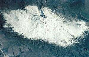 taken from the Space Shuttle on 18 March 2001

 View of Ararat from Khor Virap, Armenia
 View of Ararat from Iğdır, Turkey
 from Doğubeyazıt
 from Iğdır
 from Nakhchivan
References
Notes
- ↑ The only permitted route to climb Mount Ararat begins in Doğubeyazıt, optionally by automobile. Ministry of Culture and Tourism (2005).[5]
- ↑ Bodie Hodge writes, "Ararat and Urartu are spelled the same in Hebrew (no vowels in Hebrew, so it would be "rrt" for both with their Hebrew letters), but pronounced differently."[20]
- ↑ Strabo, Geographica, XI.14.2 and XI.14.14.[33] They are also transliterated as Abus and Nibarus.[34] Abos and Nibaros are the two peaks of Ararat according to scholars such as Nicholas Adontz,[33] Vladimir Minorsky,[35] Julius Fürst.[36]
- ↑
- Richard James Fischer: "The Genesis text, using the plural "mountains" (or hills), identifies no particular mountain, but points generally toward Armenia ("Ararat" being identical with the Assyrian "Urartu") which is broadly embraces that region."[72]
- Exell, Joseph S.; Spence-Jones, Henry Donald Maurice (eds.). "Genesis". The Pulpit Commentary.
It is agreed by all that the term Ararat describes a region.
view online - Dummelow, John, ed. (1909). "Genesis". John Dummelow's Commentary on the Bible.
Ararat is the Assyrian 'Urardhu,' the country round Lake Van, in what is now called Armenia [...] and perhaps it is a general expression for the hilly country which lay to the N. of Assyria. Mt. Masis, now called Mt. Ararat (a peak 17,000 ft. high), is not meant here.
view online - Bill T. Arnold: "Since the ancient kingdom of Ararat/Urartu was much more extensive geographically than this isolated location in Armenia, modern attempts to find remaints of Noah's ark here are misguided."[73]
- Vahan Kurkjian: "It has long been the notion among many Christians that Noah's Ark came to rest as the Flood subsided upon the great peak known as Mount Ararat; this assumption is based upon an erroneous reading of the 4th verse of the VIIIth chapter of Genesis. That verse does not say that the Ark landed upon Mount Ararat, but upon "the mountains of Ararat." Now, Ararat was the Hebrew version of the name, not of the mountain but of the country around it, the old Armenian homeland, whose name at other times and in other tongues appears variously as Erirath, Urartu, etc."[74]
- ↑ "upon the mountains of Ararat--or Armenia, as the word is rendered ( 2 Kings 19:37 , Isaiah 37:38 ). The mountain which tradition points to as the one on which the ark rested is now called Ara Dagh, the "finger mountain." Its summit consists of two peaks..."[92] The source erroneously calls Ararat "Ara Dagh" instead of Agri Dagh", but its translation as "finger mountain" proves it refers to Ararat.[93]
- ↑ "The sacred mountain stands in the center of historical and traditional Armenia, but today it is in Turkish territory."[113]
- ↑ "The lands of Western Armenia which Mt. Ararat represent..."[122] "mount Ararat is the symbol of banal irredentism for the territories of Western Armenia"[130]
- ↑ Hofmann suggested that "the return of the ruins of Ani and of Mount Ararat [by Turkey to Armenia], both in the immediate border area could be considered as a convincing gesture of Turkey's apologies and will for reconciliation."[148]
- ↑ Mikloško stated at a 2010 conference on Turkey's foreign policy: "Mount Ararat [represents the] Christian heritage of Armenians. Does modern Turkey consider the possibility of giving the mount back to Armenians? The return of Ararat would be an unprecedented step to signify Turkey’s willingness to build a peaceful future and promote its image at the international scene."[149]
- ↑ Štromas wrote: "The Armenians would also be right to claim from Turkey the Ararat Valley, which is an indivisible part of the Armenian homeland containing the main spiritual center and supreme symbol of Armenia's nationhood, the holy Mountain of Ararat itself."[150]
- ↑ Central Bank of the Republic of Turkey. Banknote Museum: 6. Emission Group - One Hundred Turkish Lira - I. Series, II. Series & III. Series.
- ↑ "К Арарату" ("To Ararat") and "Арарат из Эривани" ("Ararat from Erivan")
Citations
- ↑ "100 World Mountains ranked by primary factor". ii.uib.no. Institutt for informatikk University of Bergen.
- ↑ Gardaneh-e-Kuhin - Key col for Mount Ararat peakbagger.com. Retrieved 30 January 2016
- ↑ 2007 GPS survey
- ↑ "Ağrı Dağı'nın yüzde 65'i Iğdır'da". internetigdir.com (in Turkish). 22 December 2012.
...Ağrı Dağı'nın yüzölçümü olarak yüzde 65'i Iğdır sınırındadır.
- 1 2 "Ağrı – Mount Ararat". Republic of Turkey Ministry of culture and tourism (kultur.gov.tr). 2005.
- 1 2 3 Siebert, L., T. Simkin, and P. Kimberly (2010) Volcanoes of the world, 3rd ed. University of California Press, Berkeley, California. 551 pp. ISBN 978-0-520-26877-7.
- ↑ "Ağrı Dağı Milli Parkı [Ağrı Dağı National Park]". ormansu.gov.tr (in Turkish). Republic of Turkey Ministry of Forest and Water Management.
- ↑ "Ararat". Merriam-Webster.
Ar•a•rat \ˈa-rə-ˌrat\
"Ararat". Reference.com.[ar-uh-rat]
- ↑ Merriam-Webster's Geographical Dictionary (3rd ed.). Springfield, Massachusetts: Merriam-Webster. 2001. p. 63. ISBN 9780877795469.
- 1 2 3 4 5 6 7 8 9 Yilmaz, Y.; Güner, Y.; Saroğlu, F. (1998). "Geology of the quaternary volcanic centres of the east Anatolia". Journal of Volcanology and Geothermal Research. 85: 173–210. doi:10.1016/s0377-0273(98)00055-9.
- 1 2 Parrot 2016, p. 139.
- 1 2 de Planhol, X. (1986). "Ararat". Encyclopædia Iranica.
- ↑ Hovannisian, Richard G. (1973). "Armenia and the Caucasus in the Genesis of the Soviet-Turkish Entente". International Journal of Middle East Studies. 4 (2): 129. doi:10.1017/s0020743800027409. JSTOR 162238.
...Nationalist Turkey annexed the Surmalu district, embracing Mount Ararat, the historic symbol of the Armenian people.
- ↑ Parrot 2016, p. xxii.
- 1 2 Parrot 2016, p. xxiii.
- ↑ Yildiz, Kerim; Taysi, Tanyel B. (2007). The Kurds in Iran: The Past, Present and Future. London: Pluto Press. p. 71. ISBN 978-0745326696.
- ↑ Tsutsiev, Arthur (2014). Atlas of the Ethno-Political History of the Caucasus. Translated by Nora Seligman Favorov. New Haven: Yale University Press. p. 92. ISBN 978-0300153088.
- ↑ Frymer, Tikva S.; Sperling, S. David (2008). "Ararat, Armenia". Encyclopaedia Judaica (2nd ed.). view online
- 1 2 Arnold 2008, p. 104.
- ↑ Hodge, Bodie (2013). Tower of Babel: The Cultural History of Our Ancestors. New Leaf Publishing Group. p. 114. ISBN 9781614583189.
- 1 2 3 4 Hewsen, Robert H. (2001). "Armenia: The Physical Setting--Mt. Ararat". Armenia: A Historical Atlas. University of Chicago Press. p. 15. ISBN 0-226-33228-4.
- ↑ Smith, Eli (1832). "Foreign Correspondence". The Biblical Repository and Classical Review: 203.
On the last occasion we passed very near the base of that noble mountain, which is called by the Armenians, Masis, and by Europeans generally Ararat...
- 1 2 Bryce 1877, p. 198.
- 1 2 Jastrow, Jr., Morris; Kent, Charles Foster (1902). "Ararat". Jewish Encyclopedia Volume II. New York: Funk & Wagnalls Co. p. 73.
The mountain itself is known as Ararat only among Occidental geographers. The Armenians call it Massis, the Turks Aghri Dagh, and the Persians Koh i Nuh, or "the mountain of Noah."
view online - ↑ Avetisyan, Kamsar (1979). Հայրենագիտական էտյուդներ [Armenian studies sketches] (in Armenian). Yerevan: Sovetakan grogh. p. 14.
Հայերը Արարատը անվանում են Մասիս...
- ↑ "Պատմություն [History]" (in Armenian). Ministry of Foreign Affairs of the Republic of Armenia.
Բարձրավանդակի գրեթե կենտրոնում վեր է հառնում աստվածաշնչյան Արարատ (Մասիս) լեռը...
- 1 2 "Մասիսներ [Masisner]". encyclopedia.am (in Armenian).
- 1 2 Peroomian, Rubina (2007). "Historical Memory: Threading the Contemporary Literature of Armenia". In Hovannisian, Richard. The Armenian Genocide: Cultural and Ethical Legacies. Transaction Publishers. p. 113. ISBN 9781412835923.
...the majestic duo of Sis and Masis (the two peaks of Mount Ararat) that hover above the Erevan landscape are constant reminders of the historical injustice.
- ↑ Delitzsch, Franz (2001). New Commentary on Genesis. Wipf and Stock Publishers. p. 274.
The Armenians call Little Ararat sis and Great Ararat masis, whence it seems that great, the meaning of meds, is contained in ma.
- 1 2 Khorenatsi 1978, p. 91.
- 1 2 Petrossyan 2010, p. 221.
- 1 2 3 Novoseltsev 1978.
- 1 2 Petrossyan 2010, p. 220.
- ↑ Jones, Horace Leonard, ed. (1928). "XI.14". The Geography of Strabo. Harvard University Press. view Book XI, Chapter 14 online
- ↑ Minorsky, V. (1944). "Roman and Byzantine Campaigns in Atropatene". Bulletin of the School of Oriental and African Studies, University of London. 11 (2): 259.
Although what Strabo means by Abos seems to be the southern spurs of Mt. Ararat...
- ↑ Julius Fürst cited in Exell, Joseph; Jones, William; Barlow, George; Scott, W. Frank; et al. (1892). The Preacher's Complete Homiletical Commentary. "...the present Aghri Dagh or the great Ararat (Pers. Kuhi Nuch, i.e. Noah's mountain, in the classics ὁ ἄβος, Armen. massis)..." (Furst.) view online
- ↑ Dalton, Robert H. (2004). Sacred Places of the World: A Religious Journey Across the Globe. Abhishek. p. 133. ISBN 9788182470514.
The Turkish name for Mt Ararat is Agri Dagi (which means mountain of pain).
- ↑ McCarta, Robertson (1992). Turkey (2nd ed.). Nelles. p. 210. ISBN 9783886184019.
(Turkish: Agri Dagi, "Mount of Sorrows")
- 1 2 Sarıkaya, Mehmet Akif (2012). "Recession of the ice cap on Mount Ağrı (Ararat), Turkey, from 1976 to 2011 and its climatic significance". Journal of Asian Earth Sciences. 46: 190–194. doi:10.1016/j.jseaes.2011.12.009.
- ↑ "Xortekî tirk dixwaze bi bîsîklêtê xwe ji çiyayê Agirî berde xwarê" (in Kurdish). Rudaw Media Network. 19 June 2014.
- ↑ Waugh, Alexander (27 August 2008). "Will he, won't He? Ararat by Frank Westerman, translated by Sam Garrett". The Spectator.
- ↑ SRTM data for Mount Ararat
- ↑ Mount Ararat Trip Report
- ↑ Detailed topographic maps of Mount Ararat
- 1 2 3 Blumenthal, M. M. (1958). "Vom Agrl Dag (Ararat) zum Kagkar Dag. Bergfahrten in nordostanatolischen Grenzlande". Die Alpen. 34: 125–137.
- 1 2 Sarıkaya, M.A., and A.E. Tekeli (2014) Satellite inventory of glaciers in Turkey. In J. S. Kargel and others, eds., pp. 465-480, Global Land Ice Measurements from Space. Springer Praxis Books, Springer-Verlag, New York. 876 pp. ISBN 978-3540798170
- 1 2 Birman, J.H., (1968) Glacial Reconnaissance in Turkey. Geological Society of America Bulletin. vol. 79, no. 8, pp. 1009-1026.
- 1 2 Dewey, J.F., M.R. Hempton, W.S.F. Kidd, F. Saroglum and A.M.C. Sengὃr (1986) Shortening of continental lithosphere: the neotectonics of Eastern Anatolia - a young collision zone. In M.P. Coward, and A.C. Ries, eds., pp. pp. 3-36, Collision Tectonics. Special Publication No. 19, Geological Society of London, London, United Kingdom.
- 1 2 3 4 Karakhanian, A.; Djrbashian, R.; Trifonov, V.; Philip, H.; Arakelian, S.; Avagian, A. (2002). "Holocene–Historical Volcanism and Active Faults as Natural Risk Factor for Armenia and Adjacent Countries". Journal of Volcanology and Geothermal Research. 113 (1): 319–344. doi:10.1016/s0377-0273(01)00264-5.
- 1 2 3 4 Karakhanian, A.S.; Trifonov, V.G.; Philip, H.; Avagyan, A.; Hessami, K.; Jamali, F.; Bayraktutan, M. S.; Bagdassarian, H.; Arakelian, S.; Davtian, V.; Adilkhanyan, A. (2004). "Active faulting and natural hazards in Armenia, Eastern Turkey and North-Western Iran". Tectonophysics. 380: 189– 219. doi:10.1016/j.tecto.2003.09.020.
- ↑ Allen, Mark B.; Mark, Darren F.; Kheirkhah, Monireh; Barfod, Dan; Emami, Mohammad H.; Saville, Christopher (2011). "40Ar/39Ar dating of Quaternary lavas in northwest Iran: constraints on the landscape evolution and incision rates of the Turkish–Iranian plateau". Geophysical Journal International. 185: 1175–1188. doi:10.1111/j.1365-246x.2011.05022.x.
- 1 2 Haroutiunian, R. A. (2005). "Катастрофическое извержение вулкана Арарат 2 июля 1840 года [Catastrophic eruption of volcano Ararat on 2 july, 1840]". Proceedings: Earth Sciences (in Russian). Armenian National Academy of Sciences. 58 (1): 27–35. ISSN 0515-961X.
- ↑ Taymaz, Tuncay; Eyidog̃an, Haluk; Jackson, James (1991). "Source parameters of large earthquakes in the East Anatolian fault zone (Turkey)". Geophysical Journal International. 106: 537–550. doi:10.1111/j.1365-246x.1991.tb06328.x.
- 1 2 William of Rubruck (1998). The Journey of William of Rubruck to the Eastern Parts of the World, 1253-55. W. W. Rockhill (translator). New Delhi: Asian Educational Services. p. 269–270. ISBN 9788120613386.
[...] mountains in which they say that Noah's ark rests; and there are two mountains, the one greater than the other; and the Araxes flows at their base [...] Many have tried to climb it, but none has been able. [...] An old man gave me quite a good reason why one ought not to try to climb it. They call the mountain Massis [...] "No one," he said, "ought to climb up Massis; it is the mother of the world."
- ↑ Siekierski, Konrad (2014). ""One Nation, One Faith, One Church": The Armenian Apostolic Church and the Ethno-Religion in Post-Soviet Armenia". In Agadjanian, Alexander. Armenian Christianity Today: Identity Politics and Popular Practice. Ashgate Publishing. p. 14. ISBN 9781472412737.
- 1 2 Randveer, Lauri. "How the Future Rector Conquered Ararat". University of Tartu.
- ↑ Khachaturian, Lisa (2011). Cultivating Nationhood in Imperial Russia: The Periodical Press and the Formation of a Modern Armenian Identity. Transaction Publishers. p. 52. ISBN 9781412813723.
- ↑ Milner, Thomas (1872). The Gallery of Geography: A Pictorial and Descriptive Tour of the World, Volume 2. W.R. M'Phun & Son. p. 783.
Great Ararat was ascended for the first time by Professor Parrot, October 9, 1829...
- ↑ Ketchian, Philip K. (December 24, 2005). "Climbing Ararat: Then and Now". The Armenian Weekly. 71 (52). Archived from the original on September 8, 2009.
- ↑ Parrot 2016, p. 142.
- ↑ Parrot 2016, p. 141-142.
- ↑ Parrot 2016, p. 183.
- ↑ 'Journey to Ararat' Documentary Film, Golden Apricot International Film Festival, July 2013.
- ↑ Fairbairn, Patrick (1866). "Ararat". The Imperial Bible-Dictionary: Historical, Biographical, Geographical and Doctrinal - Volume I. p. 119.
- ↑ Polo, Marco; Yule, Henry (2010). The Book of Ser Marco Polo, the Venetian: Concerning the Kingdoms and Marvels of the East, Volume 1. Cambridge University Press. p. 49.
- 1 2 Bryce, James (1878). "On Armenia and Mount Ararat". Proceedings of the Royal Geographical Society of London. London: Royal Geographical Society. 22 (3): 169–186. doi:10.2307/1799899. JSTOR 1799899.
- ↑ Lynch, H. F. B. (1893). "The ascent of Ararat". The Geographical Journal. 2: 458.
- ↑ Lynch, H. F. B. (1901). Armenia, travels and studies. Volume I: The Russian Provinces. London: Longmans, Green, and Co. p. 176.
- ↑ "Conquering the legendary Mount Ararat". Hürriyet Daily News. 15 January 2006.
- ↑ "Genesis 8 Hebrew Transliterated Bible". biblehub.com.
- ↑ "The end of the flood. Gn.8.1-22". katapi.org. katapi bible resource.
- 1 2 Richard James Fischer (2007). "Mount Ararat". Historical Genesis: From Adam to Abraham. University Press of America. pp. 109–111. ISBN 9780761838074.
- 1 2 Arnold 2008, p. 105.
- ↑ Kurkjian, Vahan (1964) [1958]. A History of Armenia. New York: Armenian General Benevolent Union of America. p. 2.
- ↑ "Douay-Rheims Bible + Latin Vulgate". Douay-Rheims Bible Online.
- 1 2 3 Vos, Howard F. (1982). "Flood (Genesis)". In Bromiley, Geoffrey W. International Standard Bible Encyclopedia: E-J (fully revised ed.). Wm. B. Eerdmans Publishing. p. 319. ISBN 0-8028-3782-4.
- ↑ Tremblais, Jean-Louis (16 July 2011). "Ararat, montagne biblique". Le Figaro (in French).
- ↑ "Biblical mountain's glaciers shrinking". News24. 8 August 2010.
- 1 2 Avagyan, Ṛafayel (1998). Yerevan--heart of Armenia: meetings on the roads of time. Union of Writers of Armenia. p. 17.
The sacred biblical mountain prevailing over Yerevan was the very visiting card by which foreigners came to know our country.
- ↑ Spar, Ira (2003). "The Mesopotamian Legacy: Origins of the Genesis tradition". In Aruz, Joan. Art of the First Cities: The Third Millennium B.C. from the Mediterranean to the Indus. New York: Metropolitan Museum of Art. p. 488. ISBN 9781588390431.
- ↑ Bailey, Lloyd R. (1990). "Ararat". In Mills, Watson E.; Bullard, Roger Aubrey. Mercer Dictionary of the Bible. Mercer University Press. p. 54.
...the local (Armenian) population called Masis and which they began to identify as the ark's landing place in the eleventh-twelfth centuries.
- ↑ Conybeare, F. C. (1901). "Reviewed Work: Ararat und Masis. Studien zur armenischen Altertumskunde und Litteratur by Friedrich Murad". The American Journal of Theology. 5 (2): 335–337. doi:10.1086/477703. JSTOR 3152410.
Masis was anyhow a center and focus of pagan myths and cults, which the author enumerates; and it was only in the eleventh century, after these had vanished from the popular mind, that the Armenian theologians ventured to locate on its eternal snows the resting-place of Noah's ark.
- 1 2 Spencer, Lee; Lienard, Jean Luc (2005). "The Search for Noah's Ark". Southwestern Adventist University. (archived)
- ↑ Mandel, Jerome (2013). "Ararat, Mount". In Friedman, John Block; Figg, Kristen Mossler. Trade, Travel, and Exploration in the Middle Ages: An Encyclopedia. Routledge. p. 30. ISBN 9781135590949.
- ↑ Mandeville, John (2012). The Book of Marvels and Travels. Anthony Bale (translator). Oxford University Press. p. 70. ISBN 9780199600601.
...there's another mountain called Ararat; the Jews call this Thano, where Noah's ship rested, and it is still there. One can glimpse it from afar in clear weather, and the mountain is seven miles high.
- ↑ "Նոյն իջնում է Արարատից (1889) [Descent of Noah from Ararat (1889)]" (in Armenian). National Gallery of Armenia.
- ↑ Conway Morris, Roderick (24 February 2012). "The Key to Armenia's Survival". The New York Times.
- ↑ "Homily of John Paul II". vatican.va. Holy See. 26 September 2001.
- ↑ "Приветственная речь Святейшего Патриарха Кирилла в кафедральном соборе Эчмиадзина [Welcome speech by His Holiness Patriarch Kirill at the Cathedral of Etchmiadzin]". patriarchia.ru (in Russian). Russian Orthodox Church. 16 March 2010.
Каждый, кто приезжает в Армению, получает неизгладимое впечатление, лицезрея ее главный символ — священную гору Арарат, на которой остановился после потопа ковчег праотца Ноя.
- 1 2 original title: Dictionnaire historique, critique, chronologique, geographique et literal de la Bible. English translation: Calmet, Augustin (1830). "Ararat". Calmet's Dictionary of the Holy Bible: With the Biblical Fragments, Volume 1. Charles Taylor (translator). London: Holdsworth and Ball. p. 178–179.
- ↑ Dwight 1856, p. 189: "The mountain on which, according to ancient Armenian tradition, and the general opinion of the learned in Europe, the ark of Noah rested after the deluge, is called in Armenian Masis, and in Turkish Aghur Dagh..."
- ↑ Jamieson, Robert; Fausset, Andrew Robert; Brown, David (1871). Commentary Critical and Explanatory on the Whole Bible. view Genesis 8:4 commentary online
- ↑ "Ararat". Peter Parley's Bible Gazetteer: Containing Illustrations of Bible Geography. W. Robinson. 1844. p. 23.
The Turks call it Agri-dagh, or the Finger Mountain...
- ↑ Murphy, James Gracey (1866). A Critical and Exegetical Commentary on the Book of Genesis. Warren F. Draper. p. 196.
It cannot be supposed that it rested on either of the peaks now called Ararat, as Ararat was a country, not a mountain, and these peaks do not seem suitable for the purpose.
- ↑ Mayell, Hillary (27 April 2004). "Noah's Ark Found? Turkey Expedition Planned for Summer". National Geographic. pp. 1, 2.
- ↑ Cline, Eric H. (2009). Biblical Archaeology: A Very Short Introduction. Oxford University Press. p. 72. ISBN 978-0-19-534263-5.
- ↑ Fagan, Garrett G. (2006). Archaeological Fantasies: How Pseudoarchaeology Misrepresents the Past and Misleads the Public. Psychology Press. p. 69. ISBN 9780415305921.
- ↑ Feder, Kenneth L. (2010). "Noah's Ark". Encyclopedia of Dubious Archaeology: From Atlantis to the Walam Olum: From Atlantis to the Walam Olum. ABC-CLIO. pp. 195–196.
- 1 2 Boniface, Brian; Cooper, Chris; Cooper, Robyn (2012). Worldwide Destinations: The Geography of Travel and Tourism (6th ed.). Taylor & Francis. p. 338. ISBN 978-0-415-52277-9.
The snow-capped peak of Ararat is a holy mountain and national symbol for Armenians, dominating the horizon in the capital, Erevan, yet it is virtually inaccessible as it lies across the border in Turkey.
- ↑ Lydolph, Paul E. (1979). Geography of the U.S.S.R., Topical Analysis. Misty Valley Publishing. p. 46.
...about 65 kilometers south of Yerevan where Mount Ararat reaches an elevation of 5156 meters.
- ↑ Shoemaker, M. Wesley (2014). "Armenia". Russia and The Commonwealth of Independent States 2014. Rowman & Littlefield. p. 203. ISBN 9781475812268.
Mt. Ararat, traditionally associated with Armenia, is actually in this area, the highest peak in the mountain chain that forms the border between modern-day Turkey and Armenia.
- ↑
- Levonian Cole, Teresa (30 October 2010). "Armenia opens up to visitors". Financial Times.
Ararat, the supreme symbol of Armenia...
- Kaya, Serdar (7 August 2011). "'Ağrı Dağı'nı verelim...'". Taraf (in Turkish).
Ağrı Dağı, pek çok Ermeni için neredeyse kutsal bir anlam ifade ediyor. Bunun nedeni, dağın, Ermeni tarihine ve kimliğine dair anlatılarda merkezî bir yere sahip olması. Translation: Mount Ararat has an almost sacred meaning for many Armenians. That's because the mountain has a central place in the narrative of Armenian history and identity.
- Levonian Cole, Teresa (30 October 2010). "Armenia opens up to visitors". Financial Times.
- ↑ Doyle, Rachel B. (5 October 2012). "In Armenia, Art in the Shadow of Ararat". The New York Times.
...whose national symbol, Mount Ararat, where many Christians believe Noah’s Ark landed...
- ↑ Bernbaum, Edwin (2005). "Sacred Mountains". In Taylor, Bron. Encyclopedia of Religion and Nature Volume I: A-J. Continuum. p. 1458. ISBN 978-1-84371-138-4.
The Armenian people regard Mount Ararat, a volcano in eastern Turkey believed to be the site of Noah's ark in the Bible, as the symbol of their national and cultural identity.
- ↑ Darke, Diana (2014). Eastern Turkey. Bradt Travel Guides. p. 317. ISBN 978-1-84162-490-7.
...of course Mount Ararat is for Armenians their holy mountain...
- ↑ "Арарат". Brockhaus and Efron Encyclopedic Dictionary Volume II (in Russian). 1890.
Арарат давно считался священной горой у армян...
on Russian Wikisource - ↑ Companjen, Françoise; Marácz, László Károly; Versteegh, Lia, eds. (2010). Exploring the Caucasus in the 21st Century: Essays on Culture, History and Politics in a Dynamic Context. Amsterdam University Press. pp. 12–13. ISBN 9789089641830.
- ↑ Melton, J. Gordon (2010). "Ararat, Mount". In Melton, J. Gordon; Baumann, Martin. Religions of the World: A Comprehensive Encyclopedia of Beliefs and Practices (2nd ed.). ABC-CLIO. p. 164. ISBN 9781598842043.
- 1 2 Adalian, Rouben Paul (2010). Historical Dictionary of Armenia. Lanham, Maryland: Scarecrow Press. p. 85. ISBN 978-0-8108-7450-3.
- ↑ Petrosyan, Hamlet L. (2001). "Symbols of Armenian Identity: The Sacred Mountain". In Abrahamian, Levon; Sweezy, Nancy. Armenian Folk Arts, Culture, and Identity. Indiana University Press. p. 38. ISBN 978-0-253-33704-7.
- ↑ Boltyansky, Boris (24 October 2015). "Солнце мое" (in Russian). lenta.ru.
Библейский Арарат, символ страны, стал главным брендом Армении.
- ↑ Adriaans 2011, p. 35.
- 1 2 Lottman, Herbert R. (29 February 1976). "Despite Ages of Captivity, The Armenians Persevere". The New York Times. p. 287.
- ↑ Darieva, Tsypylma (2006). "Bringing the soil back to the homeland: Reconfigurations of representation of loss in Armenia" (PDF). Comparativ: Leipziger Beiträge zur Universalgeschichte und vergleichenden Gesellschaftsforschung. Leipzig University (3): 90.
- ↑ Aytulu, Gökçe (6 May 2012). "Erivan'ın ufkunda Ağrı Dağı yok". Radikal (in Turkish).
Evet, Ağrı Dağı’nın Ermenistan’daki adı Ararat. Ama Ermenistan’dakiler için bir dağdan çok daha fazlası demek.
- ↑ Gabrielian, M. C. (1892). The Armenians: or the People of Ararat. Philadelphia: Allen, Lane & Scott.
- ↑ Burtt, Joseph (1926). The People of Ararat. London: L. and Virginia Woolf at the Hogarth Press. OCLC 3522299.
- ↑ Sakalli, Seyhun Orcan (2014). "Coexistence, Polarization and Development: The Armenian Legacy in Modern Turkey" (PDF). HEC Lausanne.
- ↑ Bryce 1877, p. 234: "To the Armenians it is the ancient sanctuary of their faith, the centre of their once famous kingdom, hallowed by a thousand traditions."
- ↑ O'Lear, Shannon (2011). "Borders in the South Caucasus". Defense & Security Analysis. Taylor & Francis. 27 (3): 271. doi:10.1080/14751798.2011.604486.
Armenian national identity is tightly bound around international recognition of that attempt to eradicate Armenians and an Armenian homeland. A critical piece of that homeland is Mount Ararat. Noah’s Ark is said to have landed on Mount Ararat, making it a particularly meaningful place for this predominantly Christian country.
- ↑ Maxoudian, Noubar (1952). "Early Armenia as an empire: The career of Tigranes III, 96–55 B.C.". Journal of The Royal Central Asian Society. 39 (2): 156–163. doi:10.1080/03068375208731438.
...Major Armenia (the area about 200 miles in every direction from Mount Ararat)...
- 1 2 Shirinian, Lorne (1992). The Republic of Armenia and the rethinking of the North-American Diaspora in literature. Edwin Mellen Press. p. 78. ISBN 978-0773496132.
- ↑ Nichanian, Marc (2002). The National Revolution. Gomidas Institute. p. 91. ISBN 978-1-903656-09-9.
- ↑ Hovannisian, Richard (1971). The Republic of Armenia: The first year, 1918–1919. University of California Press. p. 259.
- ↑ Aftandilian, Gregory L. (1981). Armenia, vision of a republic: the independence lobby in America, 1918–1927. Charles River Books. p. 25.
- ↑ Leeming, David (2006). The Oxford Companion to World Mythology. Oxford: Oxford University Press. p. 29. ISBN 978-0-19-515669-0.
- ↑ Khorenatsi 1978, p. 85.
- ↑ Panossian 2006, p. 51.
- ↑ Panossian 2006, pp. 51–52.
- ↑ Adriaans 2011, p. 48.
- ↑ Johnson, Jerry L. (2000). Crossing Borders – Confronting History: Intercultural Adjustment in the Post-Cold War World. Lanham, Maryland: University Press of America. pp. 6–7. ISBN 978-0-7618-1536-5.
Armenians view Mount Ararat as both a symbol of the Genocide and loss of hallowed land. Standing majestically on the immediate southwestern horizon, Ararat provides a daily reminder of past horror.
- ↑ Khojoyan, Sara (1 August 2008). "Beyond and Inside: Turk look on Ararat with Armenian perception". ArmeniaNow.
...Ararat, which is in the territory of modern Turkey but symbolizes the dream of all Armenians around the globe about the lands lost to the west of this biblical mountain.
- ↑ Krajeski, Jenna (July 2015). "One photographer's personal endeavor to track down survivors of the Armenian Genocide, 100 years later". Smithsonian.
- ↑ Goldman, Ari L. (18 December 1988). "A History Full of Anguish and Agony; The Armenians, Still 'Like Job's People'". The New York Times.
- ↑ Avakyan, K. R. (2009). "Աշոտ Մելքոնյան, Արարատ. Հայոց անմահության խորհուրդը [Ashot Melkonyan, Ararat. Symbol of Armenian Immortality]". Lraber Hasarakakan Gitutyunneri (in Armenian) (1): 252–257.
Պատմական ճակատագրի բերումով Արարատ-Մասիսը ոչ միայն վեհության, անհասանելիության, կատարելության մարմնավորում է, այլև 1915 թ. հայոց մեծ եղեռնից ու հայ ժողովրդի հայրենազրկումից հետո՝ բռնազավթված հայրենիքի և այն նորեն իր արդար զավակներին վերադարձելու համոզումի անկրկնելի խորհրդանիշ, աշխարհասփյուռ հայության միասնականության փարոս» (էջ 8):
- ↑ Adriaans 2011, p. 40.
- ↑ Platz, Stephanie (1996), Pasts and Futures: Space, History and Armenian Identity 1988-1994, University of Chicago, p. 34
- ↑ "State symbols of the Republic of Armenia". president.am. Office to the President of the Republic of Armenia.
- ↑ Matevosian, V.; Haytayan, P. (1984). "Սարյան Մարտիրոս (Saryan Martiros)". Soviet Armenian Encyclopedia Volume 10 (in Armenian). p. 240.
1921-ին Հ. Կոջոյանի հետ ստեղծել է Խորհրդային Հայաստանի գերբը...
- ↑ Meier, Reinhard (1975). "Soviet Armenia Today". Swiss Review of World Affairs. Neue Zürcher Zeitung. 25-26.
The impressive mountain also has its place as the central image in the coat of arms of the Armenian Soviet Republic (coupled, of course, with a five-pointed Soviet star).
- ↑ "Armenian protest against Erdogan visit turns violent". The Daily Star. 26 November 2010. Retrieved 28 June 2013.
- ↑ "Armenia: Internal Instability Ahead" (PDF). Yerevan/Brussels: International Crisis Group. 18 October 2004. p. 8. Retrieved 11 June 2014.
The Dashnaktsutiun Party, which has a major following within the diaspora, states as its goals: "The creation of a Free, Independent, and United Armenia. The borders of United Armenia shall include all territories designated as Armenia by the Treaty of Sevres as well as the regions of Artzakh [the Armenian name for Nagorno-Karabakh], Javakhk, and Nakhichevan".
- ↑ Harutyunyan, Arus (2009). Contesting National Identities in an Ethnically Homogeneous State: The Case of Armenian Democratization. Kalamazoo, Michigan: Western Michigan University. p. 89. ISBN 978-1-109-12012-7.
The ARF strives for the solution of the Armenian Cause and formation of the entire motherland with all Armenians. The party made it abundantly clear that historical justice will be achieved once ethnic Armenian repatriate to united Armenia, which in addition to its existing political boundaries would include Western Armenian territories (Eastern Turkey), Mountainous Karabagh and Nakhijevan (in Azerbaijan), and the Samtskhe-Javakheti region of the southern Georgia, bordering Armenia.
- 1 2 Balci, Bayram (2014). "Between ambition and realism: Turkey's engagement in the South Caucasus". In Agadjanian, Alexander; Jödicke, Ansgar; van der Zweerde, Evert. Religion, Nation and Democracy in the South Caucasus. Routledge. p. 260. ISBN 978-1-317-69157-0.
Armenia has not officially expressed territorial claims in respect of Turkey but the regular references to the genocide and to Mount Ararat, a national symbol for Armenians which is situated in contemporary Turkey, clearly indicates that the border with their eastern neighbour is contested.
- ↑ Phillips, David L. (2005). Unsilencing the Past: Track Two Diplomacy and Turkish-Armenian Reconciliation. New York: Berghahn Books. p. 68. ISBN 978-1-84545-007-6.
- ↑ Danielyan, Emil (28 July 2011). "Erdogan Demands Apology From Armenia". Radio Free Europe/Radio Liberty.
- ↑ Bidder, Benjamin (6 April 2010). "Serge Sarkisian on Armenian-Turkish Relations: 'We Wanted to Break Through Centuries of Hostility'". Der Spiegel.
- ↑ "Return of ruins of Ani and of Mount Ararat could be considered as convincing gesture of Turkey's apologies: Tessa Hofmann". Armenpress. 16 April 2015.
- ↑ "Frantisek Miklosko demands that Turkey return Biblical Mount Ararat to Armenians". PanARMENIAN.Net. 14 September 2010.
- ↑ Shtromas, Alexander (2003). Faulkner, Robert K.; Mahoney, Daniel J., eds. Totalitarianism and the Prospects for World Order: Closing the Door on the Twentieth Century. Lexington Books. p. 387. ISBN 0-7391-0534-5.
- 1 2 Healey, Barth (23 August 1992). "STAMPS; For Armenia, Rainbows And Eagles in Flight". The New York Times.
- ↑ Abrahamian, Levon (2007). "Dancing around the mountain: Armenian identity through rites of solidarity". In Grant, Bruce; Yalçın-Heckmann, Lale. Caucasus Paradigms: Anthropologies, Histories and the Making of a World Area. Berlin: Lit Verlag. pp. 167–188. ISBN 9783825899066.
- ↑ Sarkssian, M. S. (1963). "Հովհաննես Այվազովսկին և հայ մշակույթը [Hovhannes Ayvazovsky and Armenian Culture]". Patma-Banasirakan Handes (in Armenian). Yerevan: Armenian Academy of Sciences (4): 28.
Դեռևս 1860-ակա ն թթ. Անդրկովկասում կատարած ճանապարհորդության ժամանակ և դրանից հետո Այվազովսկին նկարում է Արարատի և Սևանի գեղատեսիլ բնության պատկերներ։ Մինչ այդ հայ նկարիչներից ոչ ոք չէր տվել Արարատը և Արարատյան դաշտը պատկերող կտավներ։
- ↑ Khachatrian, Shahen. ""Поэт моря" ["The Sea Poet"]" (in Russian). Center of Spiritual Culture, Leading and National Research Samara State Aerospace University. Archived from the original on 19 March 2014.
- ↑ "Martiros Sarian (1880-1972) View of Mount Ararat from Yerevan". Christie's. 3 June 2013.
- ↑ Antonson 2016.
- ↑ Jeffrey, David L. (1992). A Dictionary of Biblical Tradition in English Literature. Wm. B. Eerdmans Publishing. p. 287. ISBN 9780802836342.
- ↑ Wordsworth, William (1838). The Sonnets of William Wordsworth: Collected in One Volume, with a Few Additional Ones, Now First Published. E. Moxon. p. 209.
- ↑ Pushkin, Aleksandr (1974). A Journey to Arzrum. Translated by Birgitta Ingemanson. Ann Arbor: Ardis. p. 50. ISBN 978-0882330679.
- ↑ Dmitriev, Vladimir Alekseevich (2014). "Древнеармянские сюжеты в творчестве В.Я. Брюсова: к вопросу о влиянии событий Первой мировой войны на русскую литературу начала XX в.". In Bogush, V. A. Первая мировая война в исторических судьбах Европы : сб. материалов Междунар. науч. конф., г. Вилейка, 18 окт. 2014 г. (PDF) (in Russian). Minsk: Belarusian State University. p. 404.
Для В. Брюсова Арарат — это прежде всего символ, олицетворяющий древность армянского народа и его культуры...
- ↑ Siraganian, Lisa (2012). Modernism's Other Work: The Art Object's Political Life. Oxford University Press. p. 156. ISBN 9780199796557.
- ↑ Karakashian, Meliné (1998). "Armenia: A Country's History of Challenges". Journal of Social Issues. 54 (2): 381–392. doi:10.1111/j.1540-4560.1998.tb01225.x.
- 1 2 Bardakjian, Kevork B., ed. (2000). "Hovhannes Širaz". A Reference Guide to Modern Armenian Literature, 1500-1920: With an Introductory History. Wayne State University Press. p. 227. ISBN 978-0814327470.
- ↑ "I Love My Armenia by Yeghishe Charents". Ararat. New York: Armenian General Benevolent Union. 15: 46. 1960.
- ↑ Ter-Khachatryan, Yervand (11 December 2014). "Բանաստեղծը Ռավեննայում". Azg (in Armenian). Archived from the original on April 11, 2016.
- ↑ Chrysanthopoulos, Leonidas (2002). Caucasus Chronicles: Nation-building and Diplomacy in Armenia, 1993-1994. Gomidas Institute. p. 21. ISBN 9781884630057.
- ↑ Panossian 2006, p. 335.
- ↑ "We Are Few... by Barouyr Sevak". Ararat. New York: Armenian General Benevolent Union. 21-22: 5. 1978.
- ↑ "System of a Down - Holy Mountains Lyrics". genius.com.
- ↑ "Arto Tuncboyaciyan - Ararat". Sharm Holding production.
- ↑ Hogikyan, Nellie (2007). "Atom Egoyan's Post-exilic Imaginary: Representing Homeland, Imagining Family". In Burwell, Jennifer; Tschofen, Monique. Image and Territory: Essays on Atom Egoyan. Wilfrid Laurier University Press. p. 202. ISBN 9780889204874.
- ↑ Nişanyan, Sevan (2010). "Ağrı il - Merkez - Ağrı". Index Anatolicus (in Turkish).
Bibliography
General works cited in the article
- Movses Khorenatsi (1978). History of the Armenians. Robert W. Thomson (translator). Harvard University Press. ISBN 0-674-39571-9.
- Panossian, Razmik (2006). The Armenians: From Kings and Priests to Merchants and Commissars. New York: Columbia University Press. ISBN 9780231139267.
- Arnold, Bill T. (2008). Genesis. Cambridge University Press. ISBN 9780521000673.
- Adriaans, Rik (2011). "Sonorous Borders: National Cosmology & the Mediation of Collective Memory in Armenian Ethnopop Music". University of Amsterdam. pp. 24–27. Archived from the original on March 5, 2016.
Specific works on Ararat
- Parrot, Friedrich (2016) [1846]. Journey to Ararat. Translated by William Desborough Cooley. Introduction by Pietro A. Shakarian. London: Gomidas Institute. ISBN 978-1909382244.
- Dwight, H.G.O. (1856). "Armenian Traditions about Mt. Ararat". Journal of the American Oriental Society. American Oriental Society. 5: 189. doi:10.2307/592222. JSTOR 592222.
- Bryce, James (1877). Transcaucasia and Ararat: Being Notes of a Vacation Tour in Autumn of 1876. London: Macmillan and Co.
- Murad, Friedrich (1901). Ararat und Masis: Studien zur armenischen Altertumskunde und Litteratur (in German). Heidelberg: Carl Winters Universitätsbuchhandlung.
- Novoseltsev, Anatoly (1978). "О местонахождении библейской "горы Арарат" (On the location of the biblical "mountains of Ararat")". Европа в древности и средневековье (Europe in the antiquity and the Middle Ages) (in Russian). Moscow: Nauka. pp. 61–66.
- Ketchian, Philip K. (24 December 2005). "Climbing Ararat: Then and Now". The Armenian Weekly. 71 (52). Archived from the original on September 8, 2009.
- Melkonyan, Ashot (2008). Արարատ. Հայոց անմահության խորհուրդը [Ararat: Symbol of Armenian Immortality] (in Armenian). Yerevan: Tigrant Mets Publishing.
- Petrossyan, Sargis (2010). "Արարատյան լեռների հին անունների և անվանադիրների մասին [About the Ancient Names and Eponyms of the Ararat Mountains]". Patma-Banasirakan Handes (3): 220–227.
- Antonson, Rick (2016). Full Moon over Noah's Ark: An Odyssey to Mount Ararat and Beyond. Skyhorse Publishing. ISBN 9781510705678.
Books on Armenia with Ararat in their titles
- Gregory, S. M. (1920). The land of Ararat: twelve discourses on Armenia, her history and her church. London: Chiswick Press.
- Elliott, Mabel Evelyn (1924). Beginning Again at Ararat. Introduction by John H. Finley. New York: Fleming H. Revell Company.
- Yeghenian, Aghavnie Y. (2013) [1932]. The Red Flag at Ararat. Introduction by Pietro A. Shakarian. London: Sterndale Classics (Gomidas Institute). ISBN 978-1909382022.
- Burney, Charles; Lang, David Marshall (1971). The Peoples of the Hills: Ancient Ararat and Caucasus. New York: Praeger.
- Arlen, Michael J. (2006) [1975]. Passage to Ararat. New York: Farrar, Straus & Giroux. ISBN 978-0374530129.
- Suny, Ronald Grigor (1993). Looking Toward Ararat: Armenia in Modern History. Indiana University Press. ISBN 978-0253207739.
- Walker, Christopher J., ed. (1997). Visions of Ararat: Writings on Armenia. I.B. Tauris. ISBN 9781860641114.
- Asher, Armen; Minasian Asher, Teryl (2009). The Peoples of Ararat. BookSurge Publishing. ISBN 978-1439225677.
External links
| Wikimedia Commons has media related to Mount Ararat. |