Morioka
| Morioka 盛岡市 | |||
|---|---|---|---|
| Core city | |||
|
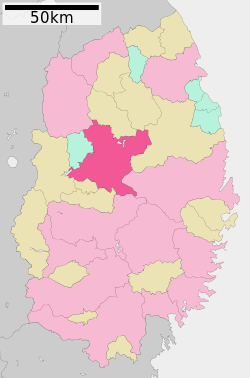
Morioka and Mount Iwate | |||
| |||
 Map of Iwate Prefecture with Morioka highlighted in pink | |||
 Morioka
| |||
| Coordinates: 39°42′7.5″N 141°09′16.2″E / 39.702083°N 141.154500°ECoordinates: 39°42′7.5″N 141°09′16.2″E / 39.702083°N 141.154500°E | |||
| Country | Japan | ||
| Region | Tōhoku | ||
| Prefecture | Iwate | ||
| Government | |||
| • -Mayor | Hiroaki Tanifuji | ||
| Area | |||
| • Total | 886.47 km2 (342.27 sq mi) | ||
| Population (September 2015) | |||
| • Total | 299,169 | ||
| • Density | 337/km2 (870/sq mi) | ||
| Time zone | Japan Standard Time (UTC+9) | ||
| Symbols | |||
| • Tree | Katsura | ||
| • Flower | Rabbit-ear iris | ||
| • Bird | Wagtail | ||
| Phone number | 019-651-4111 | ||
| Address | 12-2 Uchimaru, Morioka-shi, Iwate-ken 020-8530 | ||
| Website | Official website | ||

Morioka (盛岡市 Morioka-shi) is the capital city of Iwate Prefecture located in the Tōhoku region of northern Japan. As of September 2015, the city had an estimated population of 299,169 and a population density of 337 persons per km2. The total area was 886.47 square kilometres (342.27 sq mi).
History
The area of present-day Morioka has been continuously inhabited since the Japanese Paleolithic period. Numerous Jomon, Yayoi and Kofun period tombs and remains have been found. The Emishi inhabited the area into the Heian period. During the Enryaku era of the Heian period, Sakanoue no Tamuramaro, was ordered north to Shiwa Castle in 803 AD, as a military center to extend the domination of the Yamato dynasty over Mutsu Province. The area was later ruled by the Abe clan until their destruction during the Former Nine Years War at the hands of the Minamoto and Kiyohara clans. The Kiyohara were in turn defeated in the Gosannen War and the area came under the control of the Ōshū Fujiwara Clan based in Hiraizumi, to the south of Morioka. After the Ōshū Fujiwara were destroyed by Minamoto no Yoritomo at the start of the Kamakura period, the area was disputed by several samurai clans until the Nanbu clan, based in Sannohe to the north, expanded their territory during the Sengoku period and built Kozukata Castle in 1592.
Following the Battle of Sekigahara and the formal recognition of Morioka Domain under the Tokugawa Shogunate, Kozukata Castle was renamed Morioka Castle.[1] Its name was changed from 森岡 to 盛岡 (both read as "Morioka")[2] During the Boshin War of the Meiji restoration, Morioka Domain was a key member of the pro-Tokugawa Ōuetsu Reppan Dōmei.
After the start of the Meiji period, former Morioka Domain became Morioka Prefecture in 1870, and part of Iwate Prefecture from 1872. With the establishment of the municipality system in 1889, the city of Morioka was established and made the capital of Iwate Prefecture. The city was connected by train to Tokyo in 1890. The city emerged from World War II with very little damage, having been subject to only two minor air raids during the war.[3]
On January 10, 2006, the village of Tamayama (from Iwate District) was merged into Morioka. Morioka was proclaimed a core city in 2008, with increased local autonomy.
During the 2011 Tōhoku earthquake, Morioka was hit by a 6.1 earthquake, and numerous aftershocks, but with little damage other than extensive power outages.[4]
Geography
Morioka is located in the Kitakami Basin in central Iwate Prefecture, at the confluence of three rivers, the Kitakami, the Shizukuishi and the Nakatsu. The Kitakami River is the second largest river on the Pacific side of Japan (after the Kiso River) and the longest in the Tohoku region. It runs through the city from north to south and has a number of dams within the city boundaries, including the Shijūshida Dam and Gandō Dam. An active volcano, Mount Iwate, dominates the view to the northwest of the city. Mount Himekami is to the north and Mount Hayachine can sometimes be seen to the southeast.
Surrounding municipalities
- Iwate Prefecture
Climate
Morioka has a transitional climate between the subtropical and continental climates. It is humid, wet and snowy, also a normal feature for the area. Under the Köppen classification with an August mean of 23.4 °C (74.1 °F) and January mean of −1.9 °C (28.6 °F) it falls under the subtropical classification, due to winters being milder than the −3 °C (27 °F) isotherm for continental. Temperature differences are still largely associated with moderate continental.
| Climate data for Morioka, Iwate (1981-2010) | |||||||||||||
|---|---|---|---|---|---|---|---|---|---|---|---|---|---|
| Month | Jan | Feb | Mar | Apr | May | Jun | Jul | Aug | Sep | Oct | Nov | Dec | Year |
| Average high °C (°F) | 1.8 (35.2) |
2.9 (37.2) |
7.0 (44.6) |
14.4 (57.9) |
19.7 (67.5) |
23.5 (74.3) |
26.4 (79.5) |
28.3 (82.9) |
23.6 (74.5) |
17.6 (63.7) |
10.6 (51.1) |
4.6 (40.3) |
15.03 (59.06) |
| Daily mean °C (°F) | −1.9 (28.6) |
−1.2 (29.8) |
2.2 (36) |
8.6 (47.5) |
14.0 (57.2) |
18.3 (64.9) |
21.8 (71.2) |
23.4 (74.1) |
18.7 (65.7) |
12.1 (53.8) |
5.9 (42.6) |
1.0 (33.8) |
10.24 (50.43) |
| Average low °C (°F) | −5.6 (21.9) |
−5.2 (22.6) |
−2.2 (28) |
3.0 (37.4) |
8.5 (47.3) |
13.8 (56.8) |
18.1 (64.6) |
19.6 (67.3) |
14.6 (58.3) |
7.3 (45.1) |
1.5 (34.7) |
−2.4 (27.7) |
5.92 (42.64) |
| Average precipitation mm (inches) | 53.1 (2.091) |
48.7 (1.917) |
80.5 (3.169) |
87.5 (3.445) |
102.7 (4.043) |
110.1 (4.335) |
185.5 (7.303) |
183.8 (7.236) |
160.3 (6.311) |
93.0 (3.661) |
90.2 (3.551) |
70.8 (2.787) |
1,266.2 (49.849) |
| Average snowfall cm (inches) | 85 (33.5) |
74 (29.1) |
46 (18.1) |
4 (1.6) |
0 (0) |
0 (0) |
0 (0) |
0 (0) |
0 (0) |
0 (0) |
10 (3.9) |
53 (20.9) |
272 (107.1) |
| Average relative humidity (%) | 73 | 70 | 67 | 65 | 69 | 75 | 80 | 79 | 80 | 77 | 75 | 74 | 69 |
| Mean monthly sunshine hours | 116.9 | 127.5 | 160.4 | 173.7 | 185.4 | 154.7 | 128.5 | 149.1 | 123.7 | 145.8 | 116.9 | 101.6 | 1,684.2 |
| Source: Japan Meteorological Agency | |||||||||||||
Transportation
- East Japan Railway Company (JR East) – Tōhoku Shinkansen
- East Japan Railway Company (JR East) - Tōhoku Main Line
- Iwate-Iioka - Sembokuchō - Morioka
- East Japan Railway Company (JR East) - Tazawako Line (Akita Shinkansen)
- Morioka
- East Japan Railway Company (JR East) - Yamada Line
- Morioka - Kamimorioka - Yamagishi - Kamiyonai - Ōshida - Asagishi
- East Japan Railway Company (JR East) - Hanawa Line
- Morioka - Kōma
- Iwate Galaxy Railway Line
- Morioka – Aoyama – Kuriyagawa – Shibutami – Kōma
Highway
- Tōhoku Expressway – Morioka-Minami IC, Morioka IC
- National Route 4
- National Route 46
- National Route 106
- National Route 281
- National Route 282
- National Route 396
- National Route 455
- National Route 456
Local attractions
- The Iwate Museum of Art in Morioka displays works by three notable local artists, Tetsugoro Yorozu, Shunsuke Matsumoto and Yasutake Funakoshi, as well as holding exhibitions on national and international themes.
- Rock-Breaking Cherry Tree - designated a natural monument of Japan.
Sports venues
Temples and shrines
- Hoon-ji is a Sōtō Zen Buddhist temple which was originally built at Sannohe by the 13th lord of the Nambu clan, Nambu Moriyuki, in 1394, and brought to Morioka by the 27th lord, Nambu Toshinao. It was considered the head temple among the 280 operated by the Nambu clan. A notable feature is the Rakan-dō, built in 1735 and rebuilt in 1858. Its central statue Rushana butsu is reported to be made by Kōbō-daishi. Within the Rakan-dō are statues of the 500 Rakan, which were made in Kyoto and later brought to Morioka. Included are representations of Kublai Khan and Marco Polo. It is an active Zen training temple for monks.
- Mitsuishi (literally, 'three rocks') is a Shinto shrine which has three large rocks on the grounds with shackles around them to represent the story of 'Oni no tegata', which is a legend explaining the origin of the name of Iwate prefecture. According to the legend, there was once an Oni or demon who often tormented and harassed the local people. When the people prayed to the spirit of Mitsuishi for protection, the demon was immediately shackled to the rocks and made to promise never to trouble the people again. As a sign of this promise, the demon left a handprint on one of the rocks, thus giving rise to the name Iwate, literally meaning "rock hand".
- Morioka Hachiman Shrine
Food
Morioka attracts tourists with local noodles such as jajamen, reimen, and wanko soba. Brewing is also a thriving industry of the city. Nambu Senbei, a type of rice cracker, is considered a local specialty.
Education
University
Public High Schools
- Morioka First High School
- Morioka Second High School
- Morioka Third High School
- Morioka Fourth High School
- Morioka South High School
- Morioka Agricultural High School
- Morioka Industrial High School
- Morioka Commercial High School
- Iwate Prefectural Toryo High School
- Morioka City High School
Media
- Iwate Asahi Television
- Iwate Broadcasting Company
- Iwate Menkoi Television
- Iwate Nippo
- Television Iwate
Sports
The FIS Alpine World Ski Championships 1993 were held there.
Sister city relations
-
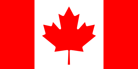 Victoria, British Columbia, Canada [5] (since 1985)
Notable persons
- Takashi Hara, former Prime Minister of Japan
- Takuboku Ishikawa - poet
- Seishirō Itagaki, general in the Imperial Japanese Army
- Yōko Mihara, actress
- Milano Collection A.T., professional wrestler[6]
- The Great Sasuke, professional wrestler
- Inazo Nitobe, author, educator, diplomat, and politician during the Meiji period and Taishō period
- Mitsuo Ogasawara, footballer
- Takatō Ōshima, engineer - made the first Western-style cannon in Japan
- Mikoi Sasaki, actress
- Mitsumasa Yonai, former Prime Minister of Japan
References
- ↑ 不来方 [Kozukata]. Dijitaru Daijisen (in Japanese). Tokyo: Shogakukan. 2013. OCLC 56431036. Retrieved 2013-02-01.
- ↑
- ↑ Ministry of Home Affairs of Japan (Japanese)
- ↑ http://www.marketwatch.com/story/new-61-magnitude-quake-hits-near-morioka-japan-2011-03-11 - retrieved March 14, 2011
- ↑ "International Exchange". List of Affiliation Partners within Prefectures. Council of Local Authorities for International Relations (CLAIR). Retrieved 21 November 2015.
- ↑ "ミラノコレクションA.T." [Milano Collection A.T.]. New Japan Pro Wrestling (in Japanese). Archived from the original on 2010-06-18. Retrieved 2014-02-03.
External links
| Wikimedia Commons has media related to Morioka, Iwate. |
-
 Morioka travel guide from Wikivoyage
 - Morioka City official website (Japanese) (English) (German)
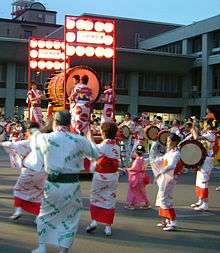
- Morioka Sansa Odori FestivalNHK(video)
- Nagai Dainenbutsu Kenbai sword dance - National Folklore Heritage in Morioka
| Core city | ||
|---|---|---|
| Cities | ||
| Isawa District | ||
| Iwate District | ||
| Kamihei District | ||
| Kesen District | ||
| Kunohe District | ||
| Ninohe District | ||
| Nishiiwai District | ||
| Shimohei District | ||
| Shiwa District | ||
| Waga District | ||