Morgan County, Missouri
| Morgan County, Missouri | |
|---|---|
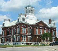 Morgan County Courthouse in Versailles | |
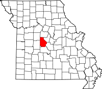 Location in the U.S. state of Missouri | |
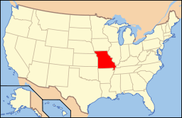 Missouri's location in the U.S. | |
| Founded | January 5, 1833 |
| Named for | Daniel Morgan |
| Seat | Versailles |
| Largest city | Versailles |
| Area | |
| • Total | 614 sq mi (1,590 km2) |
| • Land | 598 sq mi (1,549 km2) |
| • Water | 16 sq mi (41 km2), 2.7% |
| Population (est.) | |
| • (2015) | 20,171 |
| • Density | 34/sq mi (13/km²) |
| Congressional district | 4th |
| Time zone | Central: UTC-6/-5 |
| Website |
www |
Morgan County is a county located in the central portion of the U.S. state of Missouri. As of the 2010 census, the population was 20,565.[1] Its county seat is Versailles.[2] The county was organized January 5, 1833 and named for General Daniel Morgan of the American Revolutionary War.
History
Morgan County was organized in 1833 upon separation from Cooper County. It is named in honor of Revolutionary War General Daniel Morgan. Some parts of Morgan County touch the Lake of the Ozarks.
Its varied history includes the Mulhollen Station, through which mail traveled with the Butterfield Stage Line in 1858. Established in 1853, the Martin Hotel was visited by P. T. Barnum and Jesse James. Listed on the National Register of Historic Places in 1978, the Martin Hotel operates as a museum. The Morgan County Courthouse, established in Versailles, burned in 1887; however, the majority of the records were rescued, and the courthouse was soon rebuilt.
Coal mining was historically an important economic activity in Morgan County.[3]
Geography
According to the U.S. Census Bureau, the county has a total area of 614 square miles (1,590 km2), of which 598 square miles (1,550 km2) is land and 16 square miles (41 km2) (2.7%) is water.[4]
Adjacent counties
- Cooper County (north)
- Moniteau County (northeast)
- Miller County (southeast)
- Camden County (south)
- Benton County (west)
- Pettis County (northwest)
Major highways
Demographics
| Historical population | |||
|---|---|---|---|
| Census | Pop. | %± | |
| 1840 | 4,407 | — | |
| 1850 | 4,650 | 5.5% | |
| 1860 | 8,202 | 76.4% | |
| 1870 | 8,434 | 2.8% | |
| 1880 | 10,132 | 20.1% | |
| 1890 | 12,311 | 21.5% | |
| 1900 | 12,175 | −1.1% | |
| 1910 | 12,863 | 5.7% | |
| 1920 | 12,015 | −6.6% | |
| 1930 | 10,968 | −8.7% | |
| 1940 | 11,140 | 1.6% | |
| 1950 | 10,270 | −7.8% | |
| 1960 | 9,476 | −7.7% | |
| 1970 | 10,068 | 6.2% | |
| 1980 | 13,807 | 37.1% | |
| 1990 | 15,574 | 12.8% | |
| 2000 | 20,820 | 33.7% | |
| 2010 | 20,565 | −1.2% | |
| Est. 2015 | 20,171 | [5] | −1.9% |
| U.S. Decennial Census[6] 1790-1960[7] 1900-1990[8] 1990-2000[9] 2010-2015[1] | |||
As of the census[10] of 2007, there were 20,820 people, over 7,850 households, and over 5,549 families residing in the county. The population density was 32 people per square mile (12/km²). There were 13,898 housing units at an average density of 23 per square mile (9/km²). The racial makeup of the county was 97.34% White, 0.51% Black or African American, 0.63% Native American, 0.12% Asian, 0.02% Pacific Islander, 0.16% from other races, and 1.22% from two or more races. Approximately 0.83% of the population were Hispanic or Latino of any race.
There were 7,850 households out of which 26.60% had children under the age of 18 living with them, 60.50% were married couples living together, 7.10% had a female householder with no husband present, and 29.30% were non-families. 25.10% of all households were made up of individuals and 11.90% had someone living alone who was 65 years of age or older. The average household size was 2.42 and the average family size was 2.88.
In the county the population was spread out with 23.80% under the age of 18, 6.20% from 18 to 24, 23.10% from 25 to 44, 27.30% from 45 to 64, and 19.60% who were 65 years of age or older. The median age was 43 years. For every 100 females there were 97.20 males. For every 100 females age 18 and over, there were 95.00 males.
The median income for a household in the county was $30,659, and the median income for a family was $35,908. Males had a median income of $26,579 versus $19,072 for females. The per capita income for the county was $15,950. About 12.10% of families and 16.20% of the population were below the poverty line, including 25.60% of those under age 18 and 9.70% of those age 65 or over.
Education
Public schools
- Morgan County R-I School District – Stover
- Morgan County R-I Elementary School (PK-04)
- Morgan County R-I Middle School (05-08)
- Morgan County R-I High School (09-12)
- Morgan County R-II School District – Versailles
- Morgan County R-II Elementary School (PK-05)
- Morgan County R-II South Elementary School (PK-02)
- Morgan County R-II Middle School (06-08)
- Morgan County R-II High School (09-12)
Private schools
- Dogwood Grove School – Versailles (02-09) – Mennonite
- St. Paul Lutheran School – Stover (K-09) – Lutheran
Politics
Local
The Republican Party controls politics at the local level in Morgan County. Republicans hold all but five of the elected positions in the county.
| Morgan County, Missouri | ||||
|---|---|---|---|---|
| Elected countywide officials | ||||
| Assessor | Jim Anderson | Republican | ||
| Circuit Clerk | Lori Moon | Republican | ||
| County Clerk | Cathy Daniels | Democratic | ||
| Collector | Kathy Francis | Democratic | ||
| Commissioner (Presiding) |
James Bryant | Republican | ||
| Commissioner (District 1) |
Rodney Schad | Republican | ||
| Commissioner (District 2) |
Wayne Kroeschen, Jr. | Republican | ||
| Coroner | Maynard B. Jones | Democratic | ||
| Prosecuting Attorney | Dustin Dunklee | Democratic | ||
| Public Administrator | Amanda Huffman | Republican | ||
| Recorder | Nancy Boles | Republican | ||
| Sheriff | Jim Petty | Democratic | ||
| Surveyor | Lonny Allen | Republican | ||
| Treasurer | Kimberly Gunn Ingersoll | Republican | ||
State
| Year | Republican | Democratic | Third Parties |
|---|---|---|---|
| 2008 | 47.58% 4,333 | 50.18% 4,570 | 2.24% 204 |
| 2004 | 60.18% 5,273 | 38.54% 3,377 | 1.27% 112 |
| 2000 | 53.57% 4,207 | 43.60% 3,424 | 2.83% 223 |
| 1996 | 45.08% 3,220 | 51.99% 3,714 | 2.93% 209 |
Morgan County is divided into four legislative districts in the Missouri House of Representatives, all of which are held by Republicans.
- District 115 – Rodney Schad (R-Versailles). Consists of the communities of Barnett and Gravois Mills.
| Party | Candidate | Votes | % | ± | |
|---|---|---|---|---|---|
| Republican | Rodney Schad | 1,884 | 79.73 | ||
| Independent | Randy Dinwiddie | 479 | 20.27 | ||
- District 116 – Wanda Brown (R-Lincoln). Consists of the communities of Laurie, Stover, and Versailles.
| Party | Candidate | Votes | % | ± | |
|---|---|---|---|---|---|
| Republican | Wanda Brown | 2,847 | 68.98 | ||
| Democratic | Mike Stevenson | 1,132 | 27.43 | ||
| Constitution | Ray Herron | 148 | 3.59 | ||
- District 117 – Caleb Jones (R-California). Consists of a small portion of the county.
| Party | Candidate | Votes | % | ± | |
|---|---|---|---|---|---|
| Republican | Caleb Jones | 260 | 73.45 | ||
| Libertarian | Jacob Luetkemeyer | 94 | 26.55 | ||
- District 155 – Diane Franklin (R-Camdenton). Consists of the community of Sunrise Beach.
| Party | Candidate | Votes | % | ± | |
|---|---|---|---|---|---|
| Republican | Diane Franklin | 20 | 60.61 | ||
| Democratic | John W. Page | 13 | 39.39 | ||
All of Morgan County is a part of Missouri’s 6th District in the Missouri Senate and is currently represented by Mike Kehoe (R-Jefferson City).
| Party | Candidate | Votes | % | ± | |
|---|---|---|---|---|---|
| Republican | Mike Kehoe | 5,848 | 100.00 | ||
Federal
All of Morgan County is included in Missouri’s 4th Congressional District and is currently represented by Vicky Hartzler (R-Harrisonville) in the U.S. House of Representatives.
| Party | Candidate | Votes | % | ± | |
|---|---|---|---|---|---|
| Republican | Vicky Hartzler | 3,436 | 48.70 | ||
| Democratic | Ike Skelton | 3,265 | 46.27 | ||
| Libertarian | Jason Michael Braun | 227 | 3.22 | ||
| Constitution | Greg Cowan | 128 | 1.81 | ||
Political culture
| Year | Republican | Democratic | Third Parties |
|---|---|---|---|
| 2008 | 59.58% 5,451 | 38.97% 3,565 | 1.45% 133 |
| 2004 | 64.50% 5,657 | 34.81% 3,053 | 0.69% 61 |
| 2000 | 56.59% 4,460 | 41.05% 3,235 | 2.36% 186 |
| 1996 | 42.89% 3,059 | 42.14% 3,006 | 14.97% 1,068 |
Missouri Presidential Preference Primary (2008)
- Former U.S. Senator Hillary Clinton (D-New York) received more votes, a total of 1,434, than any candidate from either party in Morgan County during the 2008 presidential primary.
| Morgan County, Missouri | ||
|---|---|---|
| 2008 Republican primary in Missouri | ||
| John McCain | 857 (34.29%) | |
| Mike Huckabee | 896 (35.85%) | |
| Mitt Romney | 615 (24.61%) | |
| Ron Paul | 76 (3.04%) | |
| Morgan County, Missouri | ||
|---|---|---|
| 2008 Democratic primary in Missouri | ||
| Hillary Clinton | 1,434 (62.05%) | |
| Barack Obama | 776 (33.58%) | |
| John Edwards (withdrawn) | 78 (3.38%) | |
Cities and towns
- Barnett
- Florence
- Gravois Mills
- Laurie
- Rocky Mount
- Stover
- Sunrise Beach
- Syracuse
- Versailles (county seat)
Townships
See also
References
- 1 2 "State & County QuickFacts". United States Census Bureau. Retrieved September 10, 2013.
- ↑ "Find a County". National Association of Counties. Retrieved 2011-06-07.
- ↑ Williams, Walter (1904). The State of Missouri. p. 456.
- ↑ "2010 Census Gazetteer Files". United States Census Bureau. August 22, 2012. Retrieved November 16, 2014.
- ↑ "County Totals Dataset: Population, Population Change and Estimated Components of Population Change: April 1, 2010 to July 1, 2015". Retrieved July 2, 2016.
- ↑ "U.S. Decennial Census". United States Census Bureau. Retrieved November 16, 2014.
- ↑ "Historical Census Browser". University of Virginia Library. Retrieved November 16, 2014.
- ↑ "Population of Counties by Decennial Census: 1900 to 1990". United States Census Bureau. Retrieved November 16, 2014.
- ↑ "Census 2000 PHC-T-4. Ranking Tables for Counties: 1990 and 2000" (PDF). United States Census Bureau. Retrieved November 16, 2014.
- ↑ "American FactFinder". United States Census Bureau. Retrieved 2008-01-31.
Further reading
- History of Cole, Moniteau, Morgan, Benton, Miller, Maries and Osage counties, Missouri : from the earliest time to the present, including a department devoted to the preservation of sundry personal, business,professional and the private records; besides a valuable fund of notes, original observations, etc. etc. (1889) online
External links
- Digitized 1930 Plat Book of Morgan County from University of Missouri Division of Special Collections, Archives, and Rare Books
- Morgan County Sheriff's Office
 |
Pettis County | Cooper County | Moniteau County | |
| Benton County | |
|||
| ||||
| | ||||
| Camden County | Miller County |
Municipalities and communities of Morgan County, Missouri, United States | ||
|---|---|---|
| Cities | | |
| Villages | ||
| Townships | ||
| Unincorporated communities | ||
| Ghost town | ||
| Footnotes | ‡This populated place also has portions in an adjacent county or counties | |
Coordinates: 38°26′N 92°53′W / 38.43°N 92.89°W