California State Route 60
| ||||
|---|---|---|---|---|
 | ||||
| Route information | ||||
| Defined by Streets and Highways Code § 360 | ||||
| Maintained by Caltrans | ||||
| Length: | 70 mi[1] (113 km) | |||
| Existed: | 1964 – present | |||
| Major junctions | ||||
| West end: |
| |||
|
| ||||
| East end: |
| |||
| Highway system | ||||
| ||||

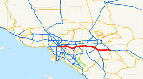
State Route 60 is a state highway in the U.S. state of California. It runs from Interstate 10 near the Los Angeles River in Los Angeles east to I-10 in Riverside County, with overlaps at State Route 57 and Interstate 215.
Route description
This route is part of the California Freeway and Expressway System.[2]
Route 60 serves the cities and communities on the eastern side of the Los Angeles metropolitan area and runs along the south side of the San Gabriel Valley. The west terminus of the freeway is at the East Los Angeles Interchange complex. The east terminus is at the junction with Interstate 10 (I-10) in Beaumont. The freeway is known as the Pomona Freeway west of its junction with State Route 91 and Interstate 215 in Riverside. East of this interchange the freeway is known as the Moreno Valley Freeway until its terminus at its junction with Interstate 10. The freeway shares the alignment of the Orange Freeway, State Route 57 for some 2 miles (3.2 km) in Diamond Bar and also shares the alignment of Interstate 215 for about 5 miles (8.0 km) in Riverside. The route takes its number from former U.S. Route 60, which now begins near Brenda, Arizona and terminates on the east coast at Virginia Beach, Virginia.
Pomona Freeway
The Pomona Freeway is the assigned name Route 60 (SR 60) between its western terminus at the East Los Angeles Interchange complex and its junction with the Riverside Freeway, State Route 91 (SR 91) and Interstate 215 (I-215) in Riverside.
It traverses Los Angeles, San Bernardino, and Riverside Counties. As it passes through many of Los Angeles' east side suburbs in southern San Gabriel and Pomona Valleys, it is a major transportation corridor. For the majority of its length it is generally parallel to, and south of, the San Bernardino Freeway, Interstate 10 (I-10), and generally parallel to, and north of, the Riverside Freeway, California State Route 91. Traffic congestion is exacerbated by the rapid population growth and, therefore, residential, commercial, and industrial development in the inland communities known informally as the Inland Empire. In particular, it has become increasingly clogged of late with shipping container-laden trucks travelling from the ports of Los Angeles and Long Beach to rail yards and warehouses in the Inland Empire.
Moreno Valley Freeway
The Moreno Valley Freeway is a freeway segment of State Route 60 and Interstate 215, connecting Riverside to communities further east in the Inland Empire and (via Interstate 10) to the Coachella Valley. Its western terminus is at the intersection of the Pomona (State Route 60) and Riverside Freeways (State Route 91 and Interstate 215), near downtown Riverside. The freeway is cosigned as State Route 60 and Interstate 215 for several miles in Riverside, traveling southeast, until the border between Riverside and Moreno Valley, where Interstate 215 branches southward as the Escondido Freeway, and State Route 60 (maintaining the Moreno Valley Freeway designation) branches eastward for approximately 20 miles (32 km). East of Moreno Valley, Route 60 technically loses its freeway status and becomes an expressway (because Caltrans has not yet found the money to close off all driveways and rebuild all at-grade intersections as grade-separated interchanges). After passing through Moreno Valley and the rugged hill country to the east (known as the Badlands to the locals), Route 60 ends at Interstate 10 in Beaumont.
As a result of the rapid development of the Inland Empire since the 1980s, the Moreno Valley Freeway now suffers from severe traffic congestion. The northwestern section that is concurrently signed with Interstate 215 recently underwent significant construction to improve traffic flow.
History
Before 1964, U.S. 60 ran from Los Angeles to the Arizona state line, where it continued its nationwide trek, often overlapping U.S. 99 and U.S. 70 along the way. The advent of Interstate 10 created a situation where, at one point, four different signed routes would run along the state-maintained highway.
In 1964, California implemented a plan to simplify its highway-numbering system, where one state highway had only one route number and concurrencies were sternly discouraged. As a result, the U.S. 60 designation (along with U.S. 70 and U.S. 99) was removed. Interstate 10 (as Route 10) superseded U.S. 60's alignment from Beaumont and towards the Arizona state line, even though the routing was only partly a freeway. This left the officially designated Route 60 from Beaumont to Los Angeles orphaned from its original U.S. Highway (which to this day begins at a point on Interstate 10 east of Quartzsite, Arizona). This new Route 60 was provisionally signed as a U.S. Highway since the designation would guide motorists from Los Angeles to Arizona in the absence of a completed freeway for Interstate 10; when all of Route 10 was upgraded to a freeway, the U.S. Highway designation disappeared.
At least one California highway sign managed to be overlooked for many years afterward. A sign on Hess Boulevard at California State Route 62 in the unincorporated town of Morongo Valley pointing not to Interstate 10 but to U.S. 60 (with evidence of the sign having pointed to both U.S. 70 and U.S. 99 as well) stood through the early 2000s. It has since been removed.[3]
The stretch of Route 60 along the Moreno Valley Freeway made national headlines in April 2004, when five-year-old Ruby Bustamante of Indio and her 26-year-old mother, Norma, were reported missing. Their car had left the road, apparently unwitnessed, between the gap in two guard rails on April 4. It then crashed underneath a tree in a deep ravine. Though Mrs. Bustamante lost her life, presumably at the moment of impact, Ruby survived on her own for ten days on cups of uncooked Top Ramen noodles and bottles of Gatorade which were in the car.[4][5][6]
On December 14, 2011, a tanker truck carrying 8,800 gallons of gasoline caught fire and exploded on the Pomona Freeway in Montebello, causing Caltrans to have to rebuild the Paramount Boulevard overpass.[7][8]
There is a project that will begin in November 2016 and will end in the middle of 2018 that will construct a partial interchange at Lemon Avenue.[9]
Exit list
Except where prefixed with a letter, postmiles were measured on the road as it was in 1964, based on the alignment that existed at the time, and do not necessarily reflect current mileage. R reflects a realignment in the route since then, M indicates a second realignment, L refers an overlap due to a correction or change, and T indicates postmiles classified as temporary (for a full list of prefixes, see the list of postmile definitions).[10] Segments that remain unconstructed or have been relinquished to local control may be omitted. The numbers reset at county lines; the start and end postmiles in each county are given in the county column.
| County | Location | Postmile [10][11][12] | Exit [13][14] | Destinations | Notes |
|---|---|---|---|---|---|
| Los Angeles LA 0.00-R30.46 | Los Angeles | 0.00 | 1A | Westbound exit and eastbound entrance; west end of SR 60/Pomona Freeway;[15] I-10 east exit 16B | |
| 0.04 | 1B | Santa Fe Avenue, Mateo Street | Westbound exit and eastbound entrance | ||
| R0.55 | 1A | Eastbound exit only; I-5 north exit 134 goes directly to I-10 west | |||
| 0.38– R0.55 | 1C | Westbound exit and eastbound entrance | |||
| R0.55 | 1E | Westbound exit and eastbound entrance; I-5 south exit 134A | |||
| R1.48 | 1D | Whittier Boulevard, Lorena Street | Signed as exit 1B eastbound; Whittier Boulevard was former US 101 | ||
| R1.94 | 2 | Indiana Street | Westbound exit and eastbound entrance | ||
| R2.59 | 3A | Downey Road | |||
| R3.27 | 3B | I-710 north exit 20A, south exit 20B | |||
| Monterey Park | R4.43 | 4 | Atlantic Boulevard | ||
| Montebello | R5.16 | 6A | Findlay Avenue | Eastbound exit and westbound entrance | |
| R5.89 | 6B | Garfield Avenue, Wilcox Avenue | Signed as exit 6 westbound | ||
| R7.77 | 8 | Paramount Boulevard – Montebello | |||
| Rosemead | R8.55 | 9 | San Gabriel Boulevard – Rosemead | ||
| 9.51 | 10A | ||||
| South El Monte | 10.23 | 10B | Santa Anita Avenue – South El Monte | ||
| 11.01 | 11 | Peck Road | |||
| Industry | 11.71 | 12 | I-605 exit 19 | ||
| 12.63 | 13 | Crossroads Parkway | |||
| Hacienda Heights | 14.26 | 14 | Seventh Avenue – Industry | Signed as exits 14A (south) and 14B (north) eastbound | |
| 15.93 | 16 | Hacienda Boulevard | Former SR 39 | ||
| Industry | 17.97 | 18 | Azusa Avenue (CR N8) | ||
| 19.46 | 19 | Fullerton Road | |||
| Rowland Heights | 20.43 | 20 | Nogales Street | ||
| Industry | R21.48 | 21 | Fairway Drive – Walnut | ||
| Diamond Bar | | 22 | Lemon Avenue | Future partial interchange; to be a three-legged interchange with no westbound exit[16][17] | |
| R22.97 | 23 | Brea Canyon Road | No westbound exit | ||
| Diamond Bar–Industry line | R23.56 | 24A | West end of SR 57 overlap; SR 57 north exit 16 | ||
| | — | HOV access only; westbound exit and eastbound entrance | |||
| R24.45 | 24B | Grand Avenue – Diamond Bar | |||
| Diamond Bar | R25.46 | 25 | East end of SR 57 overlap; eastbound exit and westbound entrance; westbound access is via exit 26 | ||
| R25.56 | 26 | Diamond Bar Boulevard | |||
| Pomona | R28.04 | 28 | Phillips Ranch Road | ||
| R29.39 | 29A | Signed as exit 29B westbound; eastbound exit to SR 71 north is via exit 29B; SR 71 north exits 12A-B, south exits 12-13 | |||
| R29.39 | 29B | Garey Avenue | Signed as exit 29A westbound | ||
| R30.33 | 30 | Reservoir Street | |||
| San Bernardino R0.00-R9.96 | Chino | R1.37 | 32 | Ramona Avenue | |
| R2.37 | 33 | Central Avenue | |||
| R3.60 | 34 | Mountain Avenue | |||
| Ontario | R4.58 | 35 | |||
| R5.86 | 36 | ||||
| R6.86 | 37 | Vineyard Avenue | |||
| R7.87 | 38 | Archibald Avenue | |||
| R8.91 | 39 | ||||
| San Bernardino–Riverside county line | R9.96 | 40 | Milliken Avenue, Hamner Avenue | Signed as exit 41A westbound; former SR 31 | |
| Riverside R0.00-30.50 | | R0.49 | 41 | Signed as exit 41B westbound; I-15 south exit 106, north exits 106A-B | |
| Jurupa Valley | R1.99 | 42 | Van Buren Boulevard, Etiwanda Avenue, Mission Boulevard | ||
| R3.03 | 43 | Country Village Road, Mission Boulevard | |||
| R4.55 | 45 | Pedley Road | |||
| R5.58 | 46 | Pyrite Street | |||
| 7.53 | 48 | Valley Way, Mission Boulevard – Rubidoux | |||
| 9.56 | 50 | Rubidoux Boulevard – Rubidoux | |||
| Riverside | 11.07 | 52A | Market Street – Downtown Riverside | ||
| 11.73 | 52B | Main Street | former US 91 / US 395 | ||
| R12.06 | 53A | Signed as exit 34B westbound; former US 91 south; east end of Pomona Freeway; SR 91 exits 65B-C | |||
| R12.21 43.27[N 1] | 53B | West end of I-215 overlap; no exit number westbound; former I-15E north / US 91 north / US 395 north; I-215 exit 34C | |||
| 42.84[N 1] | 34A[N 2] | Spruce Street | Closed[18] | ||
| 42.16[N 1] | 33[N 2] | 3rd Street, Blaine Street | |||
| 41.49[N 1] | 32[N 2] | University Avenue | former US 395 | ||
| 40.98[N 1] | 31[N 2] | Martin Luther King Boulevard | |||
| 40.28[N 1] | 31[N 2] | El Cerrito Drive | Closed[18] | ||
| 39.48[N 1] | 30B[N 2] | Watkins Drive, Central Avenue | |||
| R38.92[N 1] | 30A[N 2] | Fair Isle Drive – Box Springs | No westbound exit from I-215 north | ||
| R38.34[N 1] R12.21 | 58 | East end of I-215 overlap; no exit number eastbound; former I-15E south / US 395 south; west end of Moreno Valley Freeway; I-215 exit 29 | |||
| Moreno Valley | 13.31 | 59 | Day Street | ||
| 14.32 | 60 | Frederick Street, Pigeon Pass Road | To SR 60 Business, former US 60 east | ||
| 15.34 | 61 | Heacock Street | |||
| 16.35 | 62 | Perris Boulevard | |||
| 18.37 | 64 | Nason Street | |||
| 19.20 | 65 | Moreno Beach Drive | |||
| 20.37 | 66 | Redlands Boulevard – Moreno | |||
| 21.37 | 67 | Theodore Street | |||
| 22.10 | 68 | Gilman Springs Road – Hemet, San Jacinto | Former SR 177 | ||
| Beaumont | 27.98 | 74 | Jack Rabbit Trail | East end of freeway; interchange eastbound, at-grade intersection westbound; no exit number westbound | |
| | Western Knolls Avenue | At-grade intersection; west end of freeway | |||
| 30.50 | — | 6th Street – Beaumont | Eastbound exit and westbound entrance | ||
| 30.50 | East end of SR 60/Moreno Valley Freeway;[15] I-10 exit 93 | ||||
1.000 mi = 1.609 km; 1.000 km = 0.621 mi
| |||||
See also
-
 California Roads portal
 - Interstate 10
- U.S. Route 60
- U.S. Route 70
- U.S. Route 99
References
- ↑ January 1, 2006 California Log of Bridges on State Highways
- ↑ CA Codes (shc:250-257)
- ↑ http://www.aaroads.com/california/ca-062.html Link to California 62 article at Westcoastroads. November 2000 photo of the Morongo Valley U.S. 60 sign on Hess Boulevard is near the bottom of the page
- ↑ Pugmire, Lance; Sahagun, Louis (April 14, 2004). "Girl Survives 10 Days After Crash Killed Mom Child is found with woman's body and car near bottom of canyon". Los Angeles Times.
- ↑ Hutchinson, Bill (April 15, 2004). "How Miracle Girl Survived". The New York Daily News.
- ↑ Madigan, Nick (April 15, 2004). "5-Year-Old's Survival Tale of 10 Days Alone, Her Mother Dead". The New York Times.
- ↑ "Tanker fire: Westbound 60 freeway now open, official says". Los Angeles Times. December 17, 2011.
- ↑ Lloyd, Jonathan; Guinyard, Toni; Murphy, Sean. "Bridge to Be Demolished After Tanker Fire". KNSD.
- ↑ http://cityofdiamondbar.com/index.aspx?page=704
- 1 2 California Department of Transportation. "State Truck Route List". Sacramento: California Department of Transportation. Archived from the original (XLS file) on June 30, 2015. Retrieved June 30, 2015.
- ↑ California Department of Transportation, Log of Bridges on State Highways, July 2007
- ↑ California Department of Transportation, All Traffic Volumes on CSHS, 2005 and 2006
- ↑ California Department of Transportation, California Numbered Exit Uniform System, State Route 60 Freeway Interchanges, Retrieved on 2009-02-05.
- ↑ California Department of Transportation, California Numbered Exit Uniform System, Interstate 215 Freeway Interchanges Northbound and Interstate 215 Freeway Interchanges Southbound, Retrieved on 2009-02-05.
- 1 2 "2014 Named Freeways, Highways, Structures and Other Appurtenances in California" (PDF). California Department of Transportation. Retrieved June 20, 2015.
- ↑ "Lemon Avenue / SR-60 Interchange". City of Diamond Bar. City of Diamond Bar. Retrieved February 20, 2016.
- ↑ "State Route 60/Lemon Avenue Interchange" (PDF). Caltrans. January 2008. p. vii. Retrieved February 20, 2016.
- 1 2 Caltrans District 8: 60-91-215 Interchange Project
External links
- California @ AARoads.com - State Route 60
- Caltrans: Route 60 highway conditions
- California Highways: Route 60
- The 60/91/215 Freeway Improvement Project
| Wikimedia Commons has media related to California State Route 60. |