Morant Point
| Morant Point | |
|---|---|
| Easternmost extremity | |
|
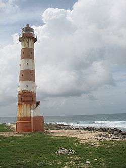
Morant Point Lighthouse looking north north east. | |
 Morant Point | |
| Coordinates: 17°54′54″N 76°11′17″W / 17.9149202°N 76.1881685°WCoordinates: 17°54′54″N 76°11′17″W / 17.9149202°N 76.1881685°W | |
| Country | Jamaica |
| Parish | St Thomas |
| Time zone | EST (UTC-5) |
Morant Point in Saint Thomas Parish is the easternmost point of mainland Jamaica and the site of Morant Point Lighthouse.
History
.jpg)
1572 map of Jamaica by Tomaso Porcacchi.
It is called Cape Morante on several early maps including one dated 1572.[1] It has had the name Morant Point since at least 1671.[2]
Climate
| Climate data for Morant Point Lighthouse | |||||||||||||
|---|---|---|---|---|---|---|---|---|---|---|---|---|---|
| Month | Jan | Feb | Mar | Apr | May | Jun | Jul | Aug | Sep | Oct | Nov | Dec | Year |
| Average high °C (°F) | 27.6 (81.7) |
27.9 (82.2) |
28.8 (83.8) |
29.3 (84.7) |
29.9 (85.8) |
30.2 (86.4) |
30.6 (87.1) |
30.9 (87.6) |
30.6 (87.1) |
30.3 (86.5) |
29.2 (84.6) |
28.2 (82.8) |
29.5 (85.1) |
| Average low °C (°F) | 22.2 (72) |
21.8 (71.2) |
22.1 (71.8) |
22.4 (72.3) |
23.2 (73.8) |
23.8 (74.8) |
24.4 (75.9) |
25.2 (77.4) |
23.4 (74.1) |
22.7 (72.9) |
23.1 (73.6) |
22.7 (72.9) |
23.1 (73.6) |
| Average precipitation mm (inches) | 89 (3.5) |
81 (3.19) |
55 (2.17) |
74 (2.91) |
178 (7.01) |
151 (5.94) |
86 (3.39) |
125 (4.92) |
188 (7.4) |
266 (10.47) |
205 (8.07) |
136 (5.35) |
1,634 (64.33) |
| Average relative humidity (%) (at 13:00) | 79 | 77 | 76 | 75 | 79 | 80 | 83 | 80 | 79 | 75 | 81 | 78 | 79 |
| Source: Meteorological Service (Jamaica)[3] | |||||||||||||
See also
External links
References
- ↑ Map of Jamaica, Tomaso Porcacchi Castilione, 1572.
- ↑ Map of Jamaica, John Ogilby, 1671.
- ↑ "Mean Climatological Data" (PDF). Meteorological Service (Jamaica). Retrieved 7 September 2016.
This article is issued from Wikipedia - version of the 9/7/2016. The text is available under the Creative Commons Attribution/Share Alike but additional terms may apply for the media files.