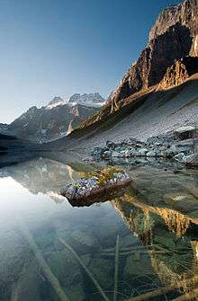
Moraine Lake
| Moraine Lake | |
|---|---|
 Moraine Lake from the Rockpile, Valley of the Ten Peaks, Alberta, Canada | |
| Location | Banff National Park, Alberta |
| Coordinates | 51°19′21″N 116°11′08″W / 51.32250°N 116.18556°WCoordinates: 51°19′21″N 116°11′08″W / 51.32250°N 116.18556°W |
| Primary inflows |
Fay Glacier Larch Creek |
| Primary outflows | Moraine Creek |
| Basin countries | Canada |
| Surface area | 0.5 km2 (0.19 sq mi) |
| Max. depth | 14 metres (46 ft) |
| Surface elevation | 1,884 m (6,181 ft) |
Moraine Lake is a glacially fed lake in Banff National Park, 14 kilometres (8.7 mi) outside the Village of Lake Louise, Alberta, Canada. It is situated in the Valley of the Ten Peaks, at an elevation of approximately 6,183 feet (1,885 m). The lake has a surface area of 0.5 square kilometres (0.19 sq mi).
The lake, being glacially fed, does not reach its crest until mid to late June. When it is full, it reflects a distinctive shade of blue. The colour is due to the refraction of light off the rock flour deposited in the lake on a continual basis.
Tourism
Hiking trails
The area around the lake has several walking/hiking trails which are, from time to time, restricted. The trail most commonly taken by tourists is The Rockpile Trail, which is along the actual moraine. The trail is approximately 300 metres long, with an elevation change of 24 metres (79 ft). The view of the lake from the top of the rockpile is one of the most photographed locations in all of Canada.[1] That view of the mountains behind the lake in Valley of the Ten Peaks is known as the Twenty Dollar View, as Moraine Lake was featured on the reverse side of the 1969 and 1979 issues of the Canadian twenty dollar bill.[2][3]
Along the same trailhead, the Consolation Lakes trail starts, which is approximately 3 kilometres (1.9 mi) long, with an elevation change of 90 metres (300 ft). Upon reaching Consolation Lakes hikers may continue along to the upper lake, which is not visible from the end of the lower lake. There is, however, no clearly marked trail, and can often be a scramble over large rocky areas.

Near the canoe docks of Moraine Lake Lodge[4] there is another trailhead. This trailhead is the start of two trails, one of which branches out into four different trails - so there are in total, five trails starting at that trailhead (Moraine Lake Lakeshore Trail, Eiffel Lake, Wenkchemna Pass, Larch Valley, and Sentinel Pass). The Lake Louise & Yoho Map[5] provides information on these trails.
Mountaineering routes
The Neil Colgan Hut can be reached in 8 to 12 hours climbing the Perren Route[6] from Moraine Lake.
Appearances

The image of Moraine Lake is world-famous and appears in many places, including:
- On the reverse side of the 1969 and 1979 issues of the Canadian twenty dollar bill.[7]
- In one of the main preview pictures for Google's operating system Android, Moraine lake was used as a background picture.
- Bernard Callebaut print advertisements
- In one of the backgrounds available on the Blackberry Pearl.
- In one of the backgrounds available on the Palm Pre
- In one of Windows 7's backgrounds in the "Canada" series.
- In one of Windows 7's backgrounds in the "Winter" series.
- As the Bing homepage on October 13, 2009, on October 2, 2013, and again on September 10, 2014.
- As the National Geographic Travel 365: Photo of the Day for October 8, 2013
- As a photo in Joel's Texas home in the video game The Last of Us
- In the login screen of Windows 10
See also
References
- ↑ Ellis, Cathy - Moraine Lake's Rockpile Trail to receive upgrades. Rocky Mountain Outlook, August 28, 2008
- ↑ Bank of Canada - 1969-1979 Canadian $20 Bank note featuring Moraine Lake
- ↑ Weddell, Peggy - Banff: A Rocky Mountain Treasure. Legion Magazine, January 1, 1997
- ↑ Moraine Lake Lodge
- ↑ Gemtreck - Lake Louise & Yoho Map
- ↑ http://www.summitpost.org/route/162264/Perren-route-to-Neil-Colgan-Hut.html Summit Post: Perren Route
- ↑ Bank of Canada - 1969-1979 Canadian $20 Bank note featuring Moraine Lake
External links
| Wikimedia Commons has media related to Moraine Lake. |
- Parks Canada - Banff National Park Visitor Information Centres, including hours of operation and contact information.
- Moraine Lake, Banff National Park
- Moraine Lake Video - Video and Geographic Position of Moraine Lake.
- Interactive Panorama: Moraine Lake