Unorganized North Algoma District
| Unorganized North Algoma District | |
|---|---|
| Unorganized area | |
| Algoma, Unorganized, North Part | |
|
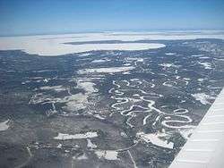
An aerial view of Goulais River. | |
 Unorganized North Algoma | |
| Coordinates: 47°30′N 84°15′W / 47.500°N 84.250°WCoordinates: 47°30′N 84°15′W / 47.500°N 84.250°W | |
| Country |
|
| Province |
|
| District | Algoma |
| Government | |
| • MPs |
Carol Hughes (NDP) Terry Sheehan (Liberal) |
| • MPPs |
Michael Mantha (NDP) David Orazietti (Liberal) |
| Area[1] | |
| • Land | 44,077.03 km2 (17,018.24 sq mi) |
| Population (2011)[1] | |
| • Total | 5,518 |
| • Density | 0.1/km2 (0.3/sq mi) |
| Time zone | EST (UTC-5) |
| • Summer (DST) | EDT (UTC-4) |
| Postal code span | P0M, P0R |
| Area code(s) | 705 |
Unorganized North Algoma District is an unorganized area in northeastern Ontario, Canada, comprising all areas in Algoma District, north of the Sault Ste. Marie to Elliot Lake corridor, which are not part of an incorporated municipality or a First Nation. It covers 44,077.03 km2 (17,018.24 sq mi) of land, and had a population of 5,717 in 2006, that dropped to 5,518 in 2011.
Local services boards
- Aweres
- Batchawana Bay
- Goulais and District
- Hawk Junction
- Missanabie
- Peace Tree
- Searchmont
- Wharncliffe and Kynoch
Communities
Agawa Bay
Agawa Bay (47°20′N 84°40′W / 47.333°N 84.667°W) is located along Highway 17 at the southern boundary of Lake Superior Provincial Park.
Amyot
Amyot (48°29′N 84°57′W / 48.483°N 84.950°W) is located on the Canadian Pacific rail line, on the shores of Negwazu Lake, around 10 km east of Highway 17.
Boon
Dalton
Dalton is an abandoned village in the middle of Highway 651 about 27 km or 30 minutes from Missanabie. There is a small train station and some old buildings that serve as cottages. The railroad passes through the little town that has some ATV trails to get to the nearby lakes.
Dunns Valley
Dunns Valley is located 30 km north of Bruce Mines at the end of Highway 670.
Fire River
Fire River is an uninhabited railway siding located west of the Missinaibi River, between the Dishnish and Argolis stations. It can only be accessed by train as there are no roads leading to it. It is located about halfway between Hearst and Chapleau
Franz
Franz (48°28′N 84°25′W / 48.467°N 84.417°W) is located at the junction of the Canadian Pacific and Algoma Central Railways near Hobon Lake, 209 kilometres (130 mi) north of Sault Ste. Marie and 65 kilometres (40 mi) from Chapleau. Franz once had a booming economy in forestry, transportation and mining. The community's original name was Hobon. In 1914, the post office's name was changed to Franz, and the railway station was renamed from Hobon to Franz Station after former Algoma Steel executive William Charles Franz. The station closed in 1991 and the building was moved to Dubreuilville where it serves as a library and tourist office.
Frater
Frater, Ontario is an uninhabited railway siding located 91 kilometres north of Sault Ste. Marie and is 3.5 kilometres from the Trans-Canada Highway and 4.3 from the shore of Lake Superior. It is located on the shores of Frater Lake.
Girdwood
Goudreau
Goudreau (48°15′00″N 84°31′59″W / 48.250°N 84.533°W) was built as a stopping point along the Algoma Central Railway.
When the Cline mine opened, Goudreau sprang to life with some 200 residents coming to the area to work. Not all of the residents worked in the mine, some of them were prospectors in search of the gold, silver, copper and iron pyrite. During the First World War, the mine was leased to the Nichols Chemicals company for the production of sulphuric acid. After the war ended, the market fell and the mine ceased operations. Other mines soon set up operations in the area. They went by the names of The Emily, Algold, Algoma Summit and The Edward. Each mine had a town site for their employees.
The town continued to grow, with the building of a two-storey railway station, workers homes and a movie theatre. A post office was built in 1915 and closed in 1966.
The Second World War ultimately led to Goudreau's demise as the demand for gold came second to iron and steel for the war. The mines eventually closed down as costs increased. Located along Highway 519, Goudreau is now a virtual ghost town, still used for logging operations and summer homes.
Goulais Mission
Hale
Haviland Bay
Haviland Bay is a small unincorporated community built around a beach on Lake Superior.
Horsey
Island Lake
Kennedy
Leeburn
Leeburn (46°28′00″N 83°48′52″W / 46.46667°N 83.81444°W) is located along Highway 638. At one time there was a gold mine at Bass Lake, a few kilometres north of Leeburn. The quality of the ore found was not sufficient to make the mine profitable.
Lochalsh
Lochalsh (48°21′00″N 84°16′00″W / 48.35000°N 84.26667°W) is a ghost town and rail siding located at the very south end of Wabatongushi Lake, along the Canadian Pacific Railway between Missanabie and Franz. A taxi ran between Lochalsh, Goudreau, and the Cline Mine. When the mine closed in 1946, both towns became ghost towns. There are still active mining operations in the area as well as a few ghost mines. The area around Lochalsh has a population of one.
Montreal River
Montreal River or Montreal River Harbour (47°14′25″N 84°38′45″W / 47.24028°N 84.64583°W) is a very small community located at the mouth of the Montreal River just south of Lake Superior Provincial Park. Immediately north of the community, the Montreal River Hill is one of the more famous segments of Ontario Highway 17, simultaneously recognized for both its scenic vistas of the surrounding wilderness and its potential to create a bottleneck in the Trans-Canada Highway system because winter storms can render it impassable.[2]
Northland Lake
The community of Northland Lake (46°42′29″N 84°7′20″W / 46.70806°N 84.12222°W) is located near Highway 556 and found by following the Northland Lake Road that intersects it . The community is mostly a collection of summer cottages. The Algoma Central Railway also operated a train station in the community by the name of Northland Station. The building still stands to this day but has been converted to a private cottage.
Norris
Oba
Oba (49°04′01″N 84°06′00″W / 49.067°N 84.100°W) is located at the junction of the Canadian National and the Algoma Central Railways, approximately halfway between Dubreuilville and Hearst. The community is also accessible by a forest roads extending from Highway 583.
Ophir
Ophir (46°27′48″N 83°43′44″W / 46.46333°N 83.72889°W) is a sparsely populated farming community located 25 km north of Bruce Mines. It is centered at the intersection of the east-west and north-south portions of Highway 638.
Non-native settlers began farming in the area around the time the mines of Bruce Mines closed in 1875. In November, 1889, William Moor, a farmer prospecting after the fall harvest, found ore containing gold atop a ridge overlooking what was then Lake Ickta (now Havilah Lake). After some ownership dispute, American investors organized the Ophir Gold Mining Company (named after the biblical Ophir) to purchase the land in 1892. A small mining town was built, and gold mining operations commenced in 1893, producing 2489 tons of ore worth $8459. Operations ceased due to a financial panic in the United States and a fatal mining accident. The name of the mine and lake were changed to Havilah, another biblical reference, as mining resumed from 1910 to 1911, but the operation and its buildings were subsequently abandoned [3][4][5]
Poplar Dale
North of Ophir, this region was settled in the late 19th century for primarily agricultural reasons. The community comprises all peoples living along the Poplar Dale Rd. and its tributaries, north of the Thessalon River. The community's major exports are beef and timber.
Ranger Lake
The community of Ranger Lake (46°52′25″N 83°34′50″W / 46.87361°N 83.58056°W) is located along Highway 556 at the south end of the lake with the same name. It is mostly a collection of summer cottages and resorts. There is an old fire tower.
Ryerson
Swanson
Wabos
Wabos (46°49′00″N 84°06′55″W / 46.81667°N 84.11528°W) is a railway siding along the Algoma Central Railway located approximately 8.6 kilometres (5.3 mi) north-west of Searchmont.
Demographics
| Canada census – Algoma, Unorganized, North Part community profile | |||
|---|---|---|---|
| 2011 | 2006 | 2001 | |
| Population: | 5518 (-3.5% from 2006) | 5717 (-6.5% from 2001) | 6114 (-0.8% from 1996) |
| Land area: | 44,077.03 km2 (17,018.24 sq mi) | 44,096.97 km2 (17,025.94 sq mi) | 44,132.64 km2 (17,039.71 sq mi) |
| Population density: | 0.1/km2 (0.26/sq mi) | 0.1/km2 (0.26/sq mi) | 0.1/km2 (0.26/sq mi) |
| Median age: | 47.2 (M: 47.5, F: 47.0) | 41.4 (M: 41.6, F: 41.2) | |
| Total private dwellings: | 5118 | 5307 | 6353 |
| Median household income: | $47,422 | $41,265 | |
| References: 2011[6] 2006[7] 2001[8] | |||
- N/A = Data not available
| Historical population | ||
|---|---|---|
| Year | Pop. | ±% |
| 1991 | 7,450 | — |
| 1996 | 7,383 | −0.9% |
| 1996 (adj.) | 6,161 | −16.6% |
| 2001 | 6,114 | −0.8% |
| 2006 | 5,717 | −6.5% |
| 2011 | 5,518 | −3.5% |
| [1][7][8][9] The 1996 population is 6,161 when adjusted to the 2001 boundaries. Area: 47,119.59 square kilometres (18,192.98 sq mi) | ||
| Visible minority and Aboriginal population (Canada 2006 Census) | |||
|---|---|---|---|
| Population group | Population | % of total population | |
| White | 5,045 | 88.1% | |
| Visible minority group Source:[10] | South Asian | 0 | 0% |
| Chinese | 0 | 0% | |
| Black | 10 | 0.2% | |
| Filipino | 75 | 1.3% | |
| Latin American | 10 | 0.2% | |
| Arab | 0 | 0% | |
| Southeast Asian | 0 | 0% | |
| West Asian | 0 | 0% | |
| Korean | 0 | 0% | |
| Japanese | 0 | 0% | |
| Visible minority, n.i.e. | 0 | 0% | |
| Multiple visible minority | 0 | 0% | |
| Total visible minority population | 95 | 1.7% | |
| Aboriginal group Source:[11] | First Nations | 285 | 5% |
| Métis | 290 | 5.1% | |
| Inuit | 0 | 0% | |
| Aboriginal, n.i.e. | 10 | 0.2% | |
| Multiple Aboriginal identity | 0 | 0% | |
| Total Aboriginal population | 585 | 10.2% | |
| Total population | 5,725 | 100% | |
See also
References
- 1 2 3 "Algoma, Unorganized, North Part census profile". 2011 Census of Population. Statistics Canada. Retrieved 2012-02-10.
- ↑ "The Montreal River hill: Nine years for nothing?". Northern Ontario Business, May 16, 2006.
- ↑ Third Report of the Bureau of Mines, 1893.
- ↑ Nineteenth Annual Report of the Bureau of Mines, 1910
- ↑ Forty-fifth Annual Report of the Ontario Department of Mines
- ↑ "2011 Community Profiles". Canada 2011 Census. Statistics Canada. July 5, 2013. Retrieved 2012-02-10.
- 1 2 "2006 Community Profiles". Canada 2006 Census. Statistics Canada. March 30, 2011. Retrieved 2009-02-24.
- 1 2 "2001 Community Profiles". Canada 2001 Census. Statistics Canada. February 17, 2012. Retrieved 2012-02-10.
- ↑ Statistics Canada: 1996 census
- ↑ Unorganized, North Part&SearchType=Begins&SearchPR=01&B1=All&Custom=, Community Profiles from the 2006 Census, Statistics Canada - Census Subdivision
- ↑ Unorganized, North Part&SearchType=Begins&SearchPR=01&B1=All&Custom=, Aboriginal Population Profile from the 2006 Census, Statistics Canada - Census Subdivision
External links

| Cities | 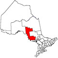 | |
|---|---|---|
| Towns | ||
| Townships | ||
| Villages | ||
| First Nations | ||
| Indian reserves | ||
| Local services boards | ||
| Unorganized areas | ||
| ||