Monterey, California
| City of Monterey | |||
|---|---|---|---|
| City | |||
|
| |||
| |||
|
Nickname(s): Language Capital of the World,[1] California's "First" City | |||
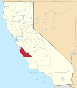
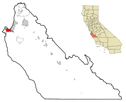 Location of Monterey, California | |||
 City of Monterey Location in the United States | |||
| Coordinates: 36°36′N 121°54′W / 36.600°N 121.900°WCoordinates: 36°36′N 121°54′W / 36.600°N 121.900°W | |||
| Country |
| ||
| State |
| ||
| County | Monterey | ||
| Incorporated | June 14, 1890[2] | ||
| Government | |||
| • Type | Council-manager | ||
| • City council[3] |
Mayor Clyde Roberson Vice Mayor Alan Haffa Timothy Barrett Libby Downey Ed Smith | ||
| • City manager | Mike McCarthy[4] | ||
| • State senator | Bill Monning (D)[5] | ||
| • Assemblymember | Mark Stone (D)[5] | ||
| • U. S. rep. | Sam Farr (D)[6] | ||
| Area[7] | |||
| • Total | 11.764 sq mi (30.469 km2) | ||
| • Land | 8.466 sq mi (21.927 km2) | ||
| • Water | 3.298 sq mi (8.542 km2) 28.03% | ||
| Elevation[8] | 26 ft (8 m) | ||
| Population (April 1, 2010)[9] | |||
| • Total | 27,810 | ||
| • Estimate (2013)[9] | 28,294 | ||
| • Density | 2,400/sq mi (910/km2) | ||
| Time zone | Pacific (UTC−8) | ||
| • Summer (DST) | PDT (UTC−7) | ||
| ZIP codes | 93940–93944 | ||
| Area code | 831 | ||
| FIPS code | 06-48872[8] | ||
| GNIS feature IDs | 1659762, 2411145 | ||
| Website |
www | ||


The City of Monterey in Monterey County is located on the southern edge of Monterey Bay, in the Northern Portion of California's Central Coast. It stands at an elevation of 26 feet (8 m) above sea level,[8] on a land area of 8.466 sq mi (21.93 km2). The 2010 census recorded a population of 27,810.
Monterey was the capital of Alta California under both Spain and Mexico. It was the only port of entry for taxable goods in California. In 1846 the U.S. flag was raised over the Customs House, and California became part of the United States after the ensuing Mexican–American War.
The city had California's first theater, public building, public library, publicly funded school, printing press, and newspaper. The city and surrounding area have attracted artists since the late 19th century and many celebrated painters and writers have lived there. Until the 1950s, there was an abundant fishery.
Among Monterey's notable present-day attractions are the Monterey Bay Aquarium, Cannery Row, Fisherman's Wharf and the annual Monterey Jazz Festival.
History
Native American period
Long before the arrival of Spanish explorers, the Rumsen Ohlone tribe, one of seven linguistically distinct Ohlone groups in California, inhabited the area now known as Monterey.[10] They subsisted by hunting, fishing and gathering food on and around the biologically rich Monterey Peninsula. Researchers have found a number of shell middens in the area and, based on the archaeological evidence, concluded the Ohlone's primary marine food consisted at various times of mussels and abalone.[11] A number of midden sites have been located along about 12 miles (19 km) of rocky coast on the Monterey Peninsula from the current site of Fishermans' Wharf in Monterey to Carmel.[12]
Spanish period
In 1602, Spanish maritime explorer Sebastian Vizcaino recorded the name "Bahía de Monterrey", which has evolved into Monterey Bay. Vizcaino landed at the southern end of the bay and described a great port, suitable for use as an anchorage by southbound Manila galleons. Vizcaino also noted and named the "Point of Pines" (labeled on today's maps as "Point Pinos", the northernmost point of the Monterey Peninsula). All other uses of the name Monterey derive from Vizcaino's name for the bay. Variants of the city's name (from the Spanish Monterrey) are recorded as Monte Rey and Montery.[13]
In 1769, the first European land exploration of Alta California, the Spanish Portolá expedition, traveled north from San Diego, seeking Vizcaino's "Port of Monterey" from 167 years earlier. For some reason, the explorers failed to recognize the place when they came to it on October 1, 1769. The party continued north as far as San Francisco Bay before turning back. On the return journey, they camped near one of Monterey's lagoons on November 27, still not convinced they had found the place Vizcaino had described. Franciscan missionary Juan Crespí noted in his diary, "We halted in sight of the Point of Pines (recognized, as was said, in the beginning of October) and camped near a small lagoon which has rather muddy water, but abounds in pasture and firewood."[14]
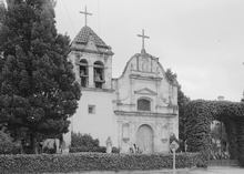
Portolá returned by land to Monterey the next year, having concluded that he must have been at Vizcaino's Port of Monterey after all. The land party was met at Monterey by Junípero Serra who traveled by sea. Portolá erected the Presidio of Monterey to defend the port and, on June 3, 1770, Serra founded the Cathedral of San Carlos Borromeo inside the presidio enclosure. Portolá returned to Mexico, replaced in Monterey by Captain Pedro Fages, who had been third in command on the exploratory expeditions. Fages became the second governor of Alta California, serving from 1770 to 1774.[15]
Serra's missionary aims soon came into conflict with Fages and the soldiers, and he moved the mission to Carmel the following year to gain greater independence from Fages. The existing wood and adobe building became the chapel for the Presidio.
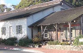
Monterey became the capital of the "Province of Both Californias" in 1777, and the chapel was renamed the Royal Presidio Chapel. The original church was destroyed by fire in 1789 and replaced by the present sandstone structure. It was completed in 1794 by Indian labor.[16] In 1840, the chapel was rededicated to the patronage of Saint Charles Borromeo. The cathedral is the oldest continuously operating parish and the oldest stone building in California. It is also the oldest (and smallest) serving cathedral along with St. Louis Cathedral in New Orleans, Louisiana. It is the only existing presidio chapel in California and the only surviving building from the original Monterey Presidio.[17]
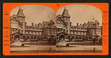
The city was originally the only port of entry for all taxable goods in California. All shipments into California by sea were required to go through the Custom House, the oldest governmental building in the state and California's Historic Landmark Number One.[18] Built in three phases, the Spanish began construction of the Custom House in 1814, the Mexican government completed the center section in 1827, and the United States government finished the lower end in 1846.[19]
.jpg)
Mexican period
Mexico gained independence from Spain in 1821, but the civil and religious institutions of Alta California remained much the same until the 1830s, when the secularization of the missions converted most of the mission pasture lands into private land grant ranchos.
Monterey was the site of the Battle of Monterey on July 7, 1846, during the Mexican-American War. It was on this date that John D. Sloat, Commodore in the United States Navy, raised the U.S. flag over the Monterey Custom House and claimed California for the United States.
In addition, many historic "firsts" occurred in Monterey. These include California's first theater, brick house, publicly funded school, public building, public library, and printing press, which printed The Californian, California's first newspaper. Larkin House,[20] one of Monterey State Historic Park’s National Historic Landmarks, built in the Mexican period by Thomas Oliver Larkin, is an early example of Monterey Colonial architecture. The old Custom House,[21] the historic district and the Royal Presidio Chapel are also National Historic Landmarks.[22] The Cooper-Molera Adobe is a National Trust Historic Site.[23]
State of California
Colton Hall,[24] built in 1849 by Walter Colton, was originally both a public school and government meeting place. It hosted California's first constitutional convention in 1849, which composed the documents necessary to apply to the United States for statehood. Today it houses a museum, while adjacent buildings serve as the seat of local government. The Monterey post office opened in 1849.[13] Monterey was incorporated in 1889.[13]
Monterey had long been famous for the abundant fishery in Monterey Bay. That changed in the 1950s when the local fishery business collapsed due to overfishing. A few of the old fishermen's cabins from the early 20th century have been preserved as they originally stood along Cannery Row.
The city has a noteworthy history as a center for California painters in the late 19th and early 20th centuries. Such painters as Arthur Frank Mathews, Armin Hansen, Xavier Martinez, Rowena Meeks Abdy and Percy Gray lived or visited to pursue painting in the style of either En plein air or Tonalism.
In addition to painters, many noted authors have also lived in and around the Monterey area, including John Steinbeck, Robinson Jeffers, Robert A. Heinlein, Henry Miller, Ed Ricketts, and Robert Louis Stevenson.
More recently, Monterey has been recognized for its significant involvement in post-secondary learning of languages other than English and its major role in delivering translation and interpretation services around the world. In November 1995, California Governor Pete Wilson proclaimed Monterey as "The Language Capital of the World".[1]
Environmental features and geography
According to the United States Census Bureau, the city has a total area of 11.7 sq mi (30.4 km2), of which 8.5 sq mi (21.9 km2) is land and 3.3 sq mi (8.5 km2) (28.05%) is water. Sand deposits in the northern coastal area comprise the sole known mineral resources.
Local soil is Quaternary Alluvium. Common soil series include the Baywood fine sand on the east side, Narlon loamy sand on the west side, Sheridan coarse sandy loam on hilly terrain, and the pale Tangair sand on hills supporting closed-cone pine habitat. The city is in a moderate to high seismic risk zone, the principal threat being the active San Andreas Fault approximately 26 miles (42 km) to the east. The Monterey Bay fault, which tracks three miles (4.8 km) to the north, is also active, as is the Palo Colorado fault seven miles (11.3 km) to the south. Also nearby, minor but potentially active, are the Berwick Canyon, Seaside, Tularcitos and Chupines faults.
Monterey Bay's maximum credible tsunami for a 100-year interval has been calculated as a wave nine feet (2.7 m) high. The considerable undeveloped area in the northwest part of the city has a high potential for landslides and erosion.
The city is adjacent to the Monterey Bay National Marine Sanctuary, a federally protected ocean area extending 276 mi (444 km) along the coast. Sometimes this sanctuary is confused with the local bay which is also termed Monterey Bay.
Soquel Canyon State Marine Conservation Area, Portuguese Ledge State Marine Conservation Area, Pacific Grove Marine Gardens State Marine Conservation Area, Lovers Point State Marine Reserve, Edward F. Ricketts State Marine Conservation Area and Asilomar State Marine Reserve are marine protected areas established by the state of California in Monterey Bay. Like underwater parks, these marine protected areas help conserve ocean wildlife and marine ecosystems.
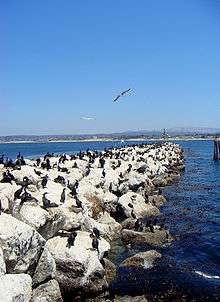
The California sea otter, a threatened subspecies, inhabits the local Monterey Bay marine environment, and a field station of The Marine Mammal Center is located in Monterey to support sea rescue operations in this section of the California coast. Monterey is home to some endangered bird species: the California clapper rail, found in salt marshes; plus the California brown pelican and the Yuma Ridgway's rail, both of whose habitats are dunes and rocky headlands. The rare San Joaquin kit fox is also found in Monterey's oak-forest and chaparral habitats. The chaparral, found mainly on the city's drier eastern slopes, hosts such plants as manzanita, chamise and ceanothus. Additional species of interest (that is, potential candidates for endangered species status) are the Salinas kangaroo rat and the silver-sided legless lizard.
There is a variety of natural habitat in Monterey: littoral zone and sand dunes; closed-cone pine forest; and Monterey Cypress. There are no dairy farms in the city of Monterey; the semi-hard cheese known as Monterey Jack originated in nearby Carmel Valley, California, and is named after businessman and land speculator David Jack.
The closed-cone pine habitat is dominated by Monterey pine, Knobcone pine and Bishop pine, and contains the rare Monterey manzanita. In the early 20th century the botanist Willis Linn Jepson characterized Monterey Peninsula's forests as the "most important silva ever", and encouraged Samuel F.B. Morse (a century younger than the inventor Samuel F. B. Morse) of the Del Monte Properties Company Properties Company to explore the possibilities of preserving the unique forest communities.[25] The dune area is no less important, as it hosts endangered species such as the vascular plants Seaside birds beak, Hickman's potentilla and Eastwood's Ericameria. Rare plants also inhabit the chaparral: Hickman's onion, Yadon's piperia (Piperia yadonii) and Sandmat manzanita. Other rare plants in Monterey include Hutchinson's delphinium, Tidestrom lupine, Gardner's yampah and Monterey Knotweed, the latter perhaps already extinct.
Monterey's noise pollution has been mapped to define the principal sources of noise and to ascertain the areas of the population exposed to significant levels. Principal sources are the Monterey Regional Airport, State Route 1 and major arterial streets such as Munras Avenue, Fremont Street, Del Monte Boulevard, and Camino Aguajito. While most of Monterey is a quiet residential city, a moderate number of people in the northern part of the city are exposed to aircraft noise at levels in excess of 60 dB on the Community Noise Equivalent Level (CNEL) scale. The most intense source is State Route 1: all residents exposed to levels greater than 65 CNEL—about 1600 people—live near State Route 1 or one of the principal arterial streets.
Surrounding towns
Monterey is located in Central Coast, surrounded by several cities and regions:
 |
Pacific Grove | Monterey Bay | Sand City, Seaside | |
| Del Monte Forest (CDP) | |
Corral de Tierra (unincorporated), Del Rey Oaks | ||
| ||||
| | ||||
| Carmel-By-The-Sea |
Climate
The climate of Monterey is regulated by its proximity to the Pacific Ocean resulting in a cool-summer Mediterranean climate (Köppen climate classification: Csb). Monterey's average high temperature ranges from around 14 °C (57 °F) in winter to 21 °C (70 °F) during the summer months. Average annual precipitation is around 19.5 inches (500 mm), with most rainfall occurring between October and April, with little to no precipitation falling during the summer months. There is an average of 70 days with measurable precipitation annually. Summers in Monterey are often cool and foggy. The cold surface waters cause even summer nights to be unusually cool for the latitude, opposite to on the U.S. east coast where coastal summer days and nights are much warmer. The extreme moderation is further underlined by that Monterey is on a similar latitude in California as Death Valley – the hottest area in the world.
During winter, snow occasionally falls in the higher elevations of the Santa Lucia Mountains and Gabilan Mountains that overlook Monterey, but snow in Monterey itself is extremely rare. A few unusual events in January 1962, February 1976, and December 1997 brought a light coating of snow to Monterey. In March 2006, a total of 3.2 inches (81 mm) fell in Monterey, including 2.2 inches (56 mm) on March 10, 2006. The snowfall on January 21, 1962, of 1.5 inches (38 mm), is remembered for delaying the Bing Crosby golf tournament in nearby Pebble Beach.
The record lowest temperature was 20 °F (−7 °C) on December 22, 1990. Annually, there are an average of 2.9 days with 90 °F (32 °C)+ highs, and an average of 2 days with lows reaching the freezing mark or lower.
The wettest year on record was 1998 with 41.01 inches (1,042 mm) of precipitation. The driest year was 1953 with 8.95 inches (227 mm). The most precipitation in one month was 14.26 inches (362 mm) in February 1998. The record maximum 24-hour precipitation was 3.85 inches (98 mm) on December 23, 1995.[26]
| Climate data for Monterey | |||||||||||||
|---|---|---|---|---|---|---|---|---|---|---|---|---|---|
| Month | Jan | Feb | Mar | Apr | May | Jun | Jul | Aug | Sep | Oct | Nov | Dec | Year |
| Record high °F (°C) | 90 (32) |
86 (30) |
85 (29) |
93 (34) |
95 (35) |
101 (38) |
98 (37) |
96 (36) |
101 (38) |
104 (40) |
95 (35) |
89 (32) |
104 (40) |
| Average high °F (°C) | 58.3 (14.6) |
59.6 (15.3) |
60.8 (16) |
62.1 (16.7) |
63.0 (17.2) |
64.9 (18.3) |
66.3 (19.1) |
67.6 (19.8) |
69.6 (20.9) |
68.2 (20.1) |
62.8 (17.1) |
57.8 (14.3) |
63.4 (17.4) |
| Average low °F (°C) | 43.7 (6.5) |
44.7 (7.1) |
45.4 (7.4) |
46.2 (7.9) |
48.1 (8.9) |
50.3 (10.2) |
52.2 (11.2) |
53.1 (11.7) |
52.8 (11.6) |
50.8 (10.4) |
47.1 (8.4) |
43.8 (6.6) |
48.2 (9) |
| Record low °F (°C) | 22 (−6) |
26 (−3) |
32 (0) |
35 (2) |
35 (2) |
41 (5) |
43 (6) |
45 (7) |
41 (5) |
35 (2) |
30 (−1) |
20 (−7) |
20 (−7) |
| Average precipitation inches (mm) | 4.40 (111.8) |
3.92 (99.6) |
3.38 (85.9) |
1.49 (37.8) |
0.56 (14.2) |
0.20 (5.1) |
0.05 (1.3) |
0.07 (1.8) |
0.24 (6.1) |
1.06 (26.9) |
2.32 (58.9) |
3.41 (86.6) |
21.10 (535.9) |
| Average precipitation days (≥ 0.01 in) | 11 | 10 | 10 | 6 | 4 | 3 | 2 | 2 | 2 | 4 | 7 | 10 | 70 |
| Source #1: WRCC (temperature and precipitation 1981-2010, extremes 1906–present)[27] | |||||||||||||
| Source #2: Weather Channel[28] | |||||||||||||
Arts and culture
Visual arts
Monterey is the home of the Monterey Museum of Art, its annex museum La Mirada and the Salvador Dali Museum. There are several commercial galleries located in the historic district of Cannery Row, New Monterey and Customs House Plaza [29]
Monterey is also the site of numerous waterfront arts and crafts festivals held in the Custom House Plaza at the top of Fisherman's Wharf.
Literary arts
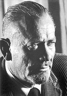

Artists who have made the area their home have included John Steinbeck, who grew up in Salinas and lived many years in nearby Pacific Grove, as well as very briefly in the city of Monterey. Steinbeck immortalized Monterey in his novels Cannery Row, Tortilla Flat, and East of Eden.
Steinbeck's friends included some of the city's more colorful characters, including Ed Ricketts, a marine biologist, and Bruce Ariss, artist and theater enthusiast who designed and built the Wharf Theater.
After Ricketts' death, the new owner of his lab and a group of friends assembled each Wednesday at the lab for drinks and jazz music. While visiting with the group, San Francisco disc jockey Jimmy Lyons suggested holding a jazz celebration in Monterey, which eventually became the Monterey Jazz Festival.[30]
In 1879 Robert Louis Stevenson spent a short time in Monterey at the French Hotel while writing The Amateur Emigrant, "The Old Pacific Capital," and "Vendetta of the West." The former hotel, now known as the "Stevenson House", stands at 530 Houston Street and features items that belonged to the writer.[31]
Music
The Monterey Jazz Festival began in 1958, presenting such artists as Louie Armstrong, Dizzy Gillespie, and Billie Holiday, and now claims to be "the longest running jazz festival in the world" (since the Newport Jazz Festival moved locations).[32]
In June 1967 the city was the venue of the Monterey Pop Festival. Formally known as the Monterey International Pop Music Festival the three-day concert event was held June 16 to June 18, 1967, at the Monterey County Fairgrounds. It was the first widely promoted and heavily attended rock festival, attracting an estimated 200,000 total attendees with 55,000 to 90,000 people present at the event's peak at midnight on Sunday. It was notable as hosting the first major American appearances by Jimi Hendrix and The Who, as well as the first major public performances of Janis Joplin and Otis Redding.[33]
The Monterey Pop Festival embodied the themes of San Francisco as a focal point for the counterculture and is generally regarded as one of the beginnings of the "Summer of Love" in 1967.[34] It also became the template for future music festivals, notably the Woodstock Festival two years later.
In 1986, the Monterey Blues Festival was created and has run continuously for over two decades.[35]
Theater arts
The building in which the first paid public dramatic entertainment in California is located in Monterey and is called, appropriately, "California's First Theater". In 1847, a sailor named Jack Swan began construction on an adobe building at the corner of Pacific St. and Scott Ave, near the Pacific House and Fisherman's Wharf. Between 1847 and 1848 several detachments of soldiers were stationed in Monterey and some of the sailors approached Swan with a proposition to lease a section of his building for use as a theater and money making venture – a proposal that Swan accepted. The enterprise collected $500 on its first performance, a considerable sum at that time. The primary mediums presented were melodramas and Olios (a form of musical revue and audience sing-along). In the spring of 1848, the play Putnam, the Iron Son of '76, was presented. After the California Gold Rush of 1849, much of the population, including Swan, traveled to northern California in search of riches. As a result, by the end that year, the company disbanded. In 1896, Swan died and the building was abandoned until 1906 when it was purchased by the California Historic Landmarks League, who deeded it to the State of California. In 1937, the building was leased to Denny-Watrous Management, who revived the tradition of melodrama at the now historic building. A resident company was created and named the Troupers of the Gold Coast, who maintained the tradition for over 50 years, closing for renovation in 1999.[36] It is now permanently closed.
In 2005, former movie-theater the Golden State Theatre located on Alvarado Street was refurbished to produce live theatrical events. The Forest Theater Guild produced several plays at the Golden State including: Aida (musical). Grease (musical), Zoot Suit (play), and Fiddler on the Roof. The theater's new owners, Eric and Lori Lochtefeld, have produced several musicals in the theater in conjunction with Broadway By the Bay.
The Bruce Ariss Wharf Theater formerly run by Angelo Di Girolamo, known now as The New Wharf Theater, whose brother had the original idea for a theater on the wharf. "The Wharf Theater" opened May 18, 1950, with a production of Happy Birthday, featuring a set design by Ariss. The theater also produced one of Bruce Ariss' original plays and was successful enough to draw the attention of MGM who brought the artist to Hollywood to work for several years. The theater was destroyed by fire December 31, 1959. It re-opened in 1960 in a new location on Alvarado Street (formerly "The Monterey Theater") and in 1963 was renamed "The Old Monterey Opera House". It continued until the mid-1960s when it fell to urban renewal. In the early 1970s, discussions began about rebuilding back on the wharf itself, and theater plans began to take shape. Designed by Ariss, the new Wharf Theater opened its doors on December 3, 1976, with a community theater production of Guys and Dolls, directed by Monterey Peninsula College Drama Department chairman, Morgan Stock. Located at the northwest end of old Fisherman's Wharf. Girolamo died in September 2014.[37][38]
Economy
Top employers
According to the City's 2015 Comprehensive Annual Financial Report,[39] the top private sector employers in the city are (in alphabetical order):
| Employer | # of Employees |
|---|---|
| Community Hospital of the Monterey Peninsula | 1,000 to 4,999 |
| Ctb Mc Graw-Hill LLC | 500 to 999 |
| Dole Fresh Vegetables | 250 to 499 |
| Hyatt Regency Monterey Hotel & Spa | 250 to 499 |
| Language Line | 250 to 499 |
| Macy's | 250 to 499 |
| Monterey Bay Aquarium | 250 to 499 |
| Monterey Institute of International Studies | 250 to 499 |
| Monterey Plaza Hotel & Spa | 250 to 499 |
| Portola Hotel & Spa | 250 to 499 |
The top public sector employers are (in alphabetical order):
| Employer | # of Employees |
|---|---|
| City of Monterey | 250 to 499 |
| Defense Language Institute | 1,000 to 4,999 |
| Monterey Peninsula College | 500 to 999 |
| Monterey-Salinas Transit | 250-499 |
| Naval Postgraduate School | 1,000 to 4,999 |
Other private sector employers based in Monterey include Monterey Peninsula Unified School District, and Mapleton Communications. Additional military facilities in Monterey include the Fleet Numerical Meteorology and Oceanography Center, and the United States Naval Research Laboratory - Monterey.
Government
Municipal government
Monterey is governed by a mayor and 4 city council members, all elected by the public.[40]
The current mayor is Clyde Roberson, and the current city council members are Alan Haffa (Vice Mayor), Libby Downey, Timothy Barrett, and Ed Smith.[3]
The City of Monterey provides base maintenance support services for the Presidio of Monterey and the Naval Postgraduate School, including streets, parks, and building maintenance. Additional support services include traffic engineering, inspections, construction engineering and project management.[41] This innovative partnership has become known as the "Monterey Model" and is now being adopted by communities across the country. This service reduces maintenance costs by millions of dollars and supports a continued military presence in Monterey.[42]
County, state, and federal representatives
Monterey is represented on the Monterey County Board of Supervisors by Supervisor Dave Potter.[43]
In the California State Legislature, Monterey is in the 17th Senate District, represented by Democrat Bill Monning, and the 29th Assembly District, represented by Democrat Mark Stone.[5]
In the United States House of Representatives, Monterey is part of California's 20th congressional district, represented by Democrat Sam Farr.[44]
Media
Local radio stations include KPIG-FM 107.5, KAZU-FM - 90.3 KDON-FM - 102.5, KCDU-FM – 101.7, KWAV-FM – 96.9, KDFG-FM – 103.9, KIDD-AM – 630, KNRY-AM – 1240, KRML 94.7 FM jazz, and 1610-AM the city information station. Television service for the community comes from the Monterey-Salinas-Santa Cruz designated market area (DMA). Local newspapers include the Monterey County Herald and the Monterey County Weekly.
Education
There are several institutions of higher education in the area: the Defense Language Institute, located on the Presidio of Monterey, California; the Naval Postgraduate School, on the site of a former resort hotel; the Middlebury Institute of International Studies at Monterey (a graduate school of Middlebury College); and Monterey Peninsula College, part of the California Community Colleges system. The federal institutions (the Defense Language Institute (DLI) and the Naval Postgraduate School (NPS)) are important employers in and strongly associated with the city.
California State University, Monterey Bay and the Monterey College of Law are located at the site of the former Fort Ord in neighboring Seaside. CSU Monterey Bay has developed several programs in marine and watershed sciences.
The Monterey Peninsula Unified School District operates a high school, a middle school and three elementary schools.[45] Private schools include Santa Catalina School (girls, co-ed elementary and middle school) and Trinity Christian High School (co-ed).
Transportation
The city is serviced by California State Route 1, also known as the Cabrillo Highway, as it runs along the coastline of the rest of Monterey Bay to the north and Big Sur to the south. California State Route 68, also known as the Monterey-Salinas Highway, connects the city to U.S. Route 101 at Salinas and to Pacific Grove.
Monterey Regional Airport connects the city to the large metropolitan areas in California, Arizona, and Nevada.
Religion
The headquarters of the Roman Catholic Diocese of Monterey in California is in Monterey, and one of the relatively few Oratorian communities in the USA is located in the city. The city is adjacent to the historic Catholic Carmel Mission.
Demographics
| Historical population | |||
|---|---|---|---|
| Census | Pop. | %± | |
| 1850 | 1,092 | — | |
| 1870 | 1,112 | — | |
| 1880 | 1,396 | 25.5% | |
| 1890 | 1,662 | 19.1% | |
| 1900 | 1,748 | 5.2% | |
| 1910 | 4,923 | 181.6% | |
| 1920 | 5,479 | 11.3% | |
| 1930 | 9,141 | 66.8% | |
| 1940 | 10,084 | 10.3% | |
| 1950 | 16,205 | 60.7% | |
| 1960 | 22,618 | 39.6% | |
| 1970 | 26,302 | 16.3% | |
| 1980 | 27,558 | 4.8% | |
| 1990 | 31,954 | 16.0% | |
| 2000 | 29,674 | −7.1% | |
| 2010 | 27,810 | −6.3% | |
| Est. 2015 | 28,338 | [46] | 1.9% |
2010
The 2010 United States Census[48] reported that Monterey had a population of 27,810. The population density was 2,364.0 people per square mile (912.7/km²). The racial makeup of Monterey was 21,788 (78.3%) White, 777 (2.8%) African American, 149 (0.5%) Native American, 2,204 (7.9%) Asian, 91 (0.3%) Pacific Islander, 1,382 (5.0%) from other races, and 1,419 (5.1%) from two or more races. There were 3,817 people of (13.7%) Hispanic or Latino origin, of any race.
The Census reported that 25,307 people (91.0% of the population) lived in households, 2,210 (7.9%) lived in non-institutionalized group quarters, and 293 (1.1%) were institutionalized.
There were 12,184 households, out of which 2,475 (20.3%) had children under the age of 18 living in them, 4,690 (38.5%) were opposite-sex married couples living together, 902 (7.4%) had a female householder with no husband present, 371 (3.0%) had a male householder with no wife present. 4,778 households (39.2%) were made up of individuals and 1,432 (11.8%) had someone living alone who was 65 years of age or older. The average household size was 2.08. There were 5,963 families (48.9% of all households); the average family size was 2.81.
The population was spread out with 4,266 people (15.3%) under the age of 18, 3,841 people (13.8%) aged 18 to 24, 8,474 people (30.5%) aged 25 to 44, 6,932 people (24.9%) aged 45 to 64, and 4,297 people (15.5%) who were 65 years of age or older. The median age was 36.9 years. For every 100 females, there were 101.2 males. For every 100 females age 18 and over, there were 100.6 males.
There were 13,584 housing units at an average density of 1,154.7 per square mile (445.8/km²), of which 4,360 (35.8%) were owner-occupied, and 7,824 (64.2%) were occupied by renters. The homeowner vacancy rate was 2.0%; the rental vacancy rate was 6.5%. 9,458 people (34.0% of the population) lived in owner-occupied housing units and 15,849 people (57.0%) lived in rental housing units.
2000
As of the census of 2000,[49] there were 29,674 people, 12,600 households, and 6,476 families residing in the city. The population density was 3,516.9 people per square mile (1,357.5/km²). There were 13,382 housing units at an average density of 1,586.0 per square mile (612.2/km²). The racial makeup of the city was 80.8% White, 10.9% Hispanic, 7.4% Asian, 2.5% African American, 0.6% Native American, 0.3% Pacific Islander, 3.9% from other races, and 4.5% from two or more races.
There were 12,600 households out of which 21.8% had children under the age of 18 living with them, 39.5% were married couples living together, 8.4% had a female householder with no husband present, and 48.6% were non-families. 37.0% of all households consist of individuals and 11.0% have a lone dweller who is over 64. The average household size was 2.13 and the average family size was 2.82.
The age distribution is as follows: 16.6% under the age of 18, 13.1% from 18 to 24, 33.8% from 25 to 44, 21.7% from 45 to 64, and 14.9% who were 65 years of age or older. The median age was 36 years. For every 100 females, there were 96.8 males. For every 100 females age 18 and over, there were 96.1 males.
The median income for a household in the city was $49,109, and the median income for a family was $58,757. Males had a median income of $40,410 versus $31,258 for females. The per capita income for the city was $27,133. About 4.4% of families and 7.8% of the population were below the poverty line, including 6.5% of those under age 18 and 4.8% of those age 65 or over.
The city is served by Monterey Regional Airport, and local bus Service is provided by Monterey-Salinas Transit. The city government's Recreation and Community Services department runs the Monterey Sports Center.[50]
Attractions
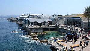
Monterey is well known for the abundance and diversity of its marine life,[51] which includes sea lions, sea otters, harbor seals, bat rays, kelp forests, pelicans and dolphins and several species of whales. Only a few miles offshore is the Monterey Canyon, the largest and deepest (3.2 km) underwater canyon off the Pacific coast of North America, which grants scientists access to the deep sea within hours.[52] The cornucopia of marine life makes Monterey a popular destination for scuba divers of all abilities ranging from novice to expert. Scuba classes are held at San Carlos State Beach,[53] which has been a favorite with divers since the 1960s. Monterey is home to one of the largest aquariums in North America, namely the Monterey Bay Aquarium, as well as several marine science laboratories, including Hopkins Marine Station.
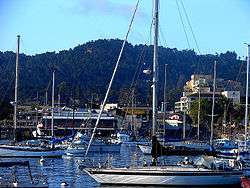
Monterey's historic Fisherman's Wharf was constructed in 1845,reconstructed in 1870 and is now a commercial shopping and restaurant district with several whale watching entities operating at the end of its pier.
Monterey is home to several museums and more than thirty carefully preserved historic buildings. Most of these buildings are adobes built in the mid-1800s, many are museums, but only open during Monterey's adobe tour. Adobes and historic structures that are open regularly are the Cooper Molera Adobe, Robert Louis Stevenson House, Casa Serrano, The Perry House, The Customs House, Colton Hall, Mayo Hayes O'Donnell Library and The First Brick House.[51][54] Monterey boasts a very active art museum, the Monterey Museum of Art and its annex museum LaMirada, which specializes in Early California Impressionist painting, photography, as well as, Contemporary art. Other youth-oriented art attractions include MY Museum, a children's museum, and YAC, an arts organization for teens.
What may be the only whalebone sidewalk still in existence in the United States lies in front of the Old Whaling Station.[55]

Cannery Row is the historic industrial district located on the ocean just west of downtown Monterey. It operated several large canneries, mostly packing sardines from the 1920s until the 1950s when the sardines were overfished and the industry collapsed. It remained largely empty from the 1950s until the late 1980s when the Monterey Bay Aquarium annexed part of the Hovden Cannery. The Aquarium revitalized this neighborhood and it is now the number one tourist destination on the Monterey Peninsula. Several of the canneries burnt down in the 1970s but their ruins can still be seen along the oceanfront. A free shuttle, The Wave, runs visitors between downtown Monterey and the Aquarium with stops in-between year round.
Once called Ocean View Boulevard, Cannery Row street was renamed in 1953 in honor of writer John Steinbeck,[56] who had written a well-known novel of the same name. It has now become a tourist attraction with numerous establishments located in former cannery buildings, including Cannery Row Antique Mall which is located in the most historically intact cannery building open to the public. Other historical buildings in this district include Wing Chong Market, The American Tin Cannery which is a shopping mall, Doc Rickett's lab, next door to the aquarium and only open to the public a few times a year, and some of the water tanks written about by Steinbeck. A few privately owned and operated fishing companies still exist on Cannery Row, housed on piers located a short distance from the historic district frequented by tourists. Cannery Row is now considered the historic cannery district from Foam St. to the ocean.
Lake El Estero is a popular Monterey park. Recreation opportunities include paddle boats, the Dennis the Menace Park (named after the comics character Dennis the Menace), and a skate park designed by local skaters. Birders are especially fond of this park due to its easy accessibility and the diversity of bird life it attracts.
Pebble Beach hosts the Pebble Beach National Pro-Am, a PGA Tour golf tournament that rotates between the Pebble Beach Golf Links, Spyglass Hill Golf Course and Poppy Hills Golf Course. The Pebble Beach Golf Links has also hosted six men's golf major tournaments.
Mazda Raceway Laguna Seca is a motorsport track near Monterey that has been used by formula, sports car and motorcycle series such as Champ Car, IMSA GT Championship, American Le Mans Series, MotoGP and Superbike World Championship.
Other attractions within easy reach of Monterey include:
Notable people
- Mike Aldrete, coach with St. Louis Cardinals and former Major League Baseball player (1986–1996)
- Gina Aliotti, IFBB professional figure champion
- John Whitby Allen, model railroader
- Paul Anka, singer, songwriter
- Jean Arthur, actress
- Art Bell, resident in the 1970s
- Tory Belleci, MythBusters
- Josh Billings, pen name for Henry Wheeler Shaw, second most famous humorist (after Mark Twain) of the mid-to-late 19th century, died at Monterey
- Lisa Bruce, film producer
- Beverly Cleary, author
- Nick Cunningham, Team USA bobsledder; 2010-2014 Winter Olympian (2-Man & 4-Man)
- Peter J. Cutino, educator and head coach of University of California (Berkeley) water polo program
- Salvador Dali, artist. Maintained a studio in the 1920s on what is now the Santa Catalina school grounds
- Doris Day, actress, singer.
- Olin Dutra, 1934 U.S. Open golf champion
- Clint Eastwood, iconic film actor, Oscar-winning director, and producer[57]
- Darcie Edgemon, children's author
- Herman Edwards, head coach with New York Jets (2001–2005) and Kansas City Chiefs (2006–2009), NFL player for Philadelphia Eagles (1977–1986), TV commentator
- Abe Espinosa, pro golfer, winner of Western Open
- Joan Fontaine, Oscar-winning actress, Rebecca (1940 film), Suspicion (1941 film)
- Percy Gray, artist, Early California Impressionist
- Richard Hamming, mathematician whose work had many implications for computer science and telecommunications
- George Lopez, comedian, actor
- Ron Johnson, American football player
- Gary Kildall, founder of Digital Research, designer of the CP/M operating system, and teacher at the Naval Postgraduate School. Lived in Pacific Grove and later Pebble Beach.
- Lou Henry Hoover (1874–1944), wife of U. S. President Herbert Hoover and First Lady of the United States, 1929-1933[58]
- Pete Incaviglia, manager of Grand Prairie AirHogs (Minor League Baseball) and Major League Baseball player (1986–1998).
- Edward Kennedy, journalist
- James Lofton, football player for Green Bay Packers, Los Angeles Raiders, Buffalo Bills, Los Angeles Rams, and Philadelphia Eagles; member of Pro Football Hall of Fame
- Jack London, author
- Katerina Moutsatsou, Greek actress
- Michael Nesmith, member of the band The Monkees, songwriter
- Kim Novak, actress
- Leon Panetta, Secretary of Defense (2011–2013), Director of the Central Intelligence Agency (2009–2011), Congressman (1977–1993) and White House Chief of Staff (1994–1997)
- Ed Ricketts (1897–1948), Marine biologist, pioneer ecologist, and key influence on John Steinbeck and Joseph Campbell
- Moqut Ruffins, American football player
- Allison Scagliotti, actress
- Jean Bruce Scott, actress
- Charles Schwab, businessman
- Vera Steadman, actress
- John Steinbeck, Nobel Prize-winning author of Of Mice and Men and The Grapes of Wrath
- Robert Louis Stevenson, Scottish author and poet, famous for writing The Strange Case of Dr Jekyll and Mr Hyde and Treasure Island, lived in Monterey during the 1870s
- Jeremy Sumpter, actor
- Edward Weston, photographer
- Betty White, actress
- Frank Zappa, musician[59]
Twin cities
Monterey is twinned with:
-
 Nanao, Ishikawa (Japan)
 -
 Monterrey (Mexico)
 -
 Dubrovnik (Croatia), since 2007
 -
 Kuşadası (Turkey), since August 6, 2007
 -
 Lankaran (Azerbaijan), since June 27, 2011[60]
See also
- Monterey State Historic Park
- Coastal California
- "Monterey", a famous song by Eric Burdon & The Animals
References
- 1 2 "Monterey - Language Capital of the World". Retrieved February 18, 2015.
- ↑ "California Cities by Incorporation Date" (Word). California Association of Local Agency Formation Commissions. Retrieved August 25, 2014.
- 1 2 "Mayor and Council Members". City of Monterey. Retrieved December 16, 2014.
- ↑ "City Manager's Office". City of Monterey. Retrieved November 23, 2014.
- 1 2 3 "Statewide Database". UC Regents. Retrieved October 16, 2014.
- ↑ "California's 20th Congressional District - Representatives & District Map". Civic Impulse, LLC. Retrieved September 24, 2014.
- ↑ "2010 Census U.S. Gazetteer Files – Places – California". United States Census Bureau.
- 1 2 3 "Monterey". Geographic Names Information System. United States Geological Survey.
- 1 2 "Monterey (city) QuickFacts". United States Census Bureau. Retrieved February 23, 2015.
- ↑ Henson, Paul; Donald J. Usner (1996). The Natural History of Big Sur (illus. by Valerie A. Kells ed.). Berkeley: University of California Press. p. 265. ISBN 0-520-20510-3.
- ↑ Breschini, Gary S.; Trudy Haversat (1986). "Archaeological Investigations at CA-MNT-149, In the Del Monte Forest, Monterey County, California". Retrieved 22 June 2012.
- ↑ Breschini, Gary S.; Trudy Haversat (Winter 2002). "Radiocarbon Dating and Cultural Models on the Monterey Peninsula, California" (PDF). Pacific Coast Archaeological Society Quarterly. 38 (1). Retrieved 22 June 2012.
- 1 2 3 Durham, David L. (1998). California's Geographic Names: A Gazetteer of Historic and Modern Names of the State. Clovis, Calif.: Word Dancer Press. p. 926. ISBN 1-884995-14-4.
- ↑ Bolton, Herbert E. (1927). Fray Juan Crespi: Missionary Explorer on the Pacific Coast, 1769-1774. HathiTrust Digital Library. pp. 240–241. Retrieved April 2014. Check date values in:
|access-date=(help) - ↑ Paddison, Joshua (ed.) (1999). A World Transformed: Firsthand Accounts of California Before the Gold Rush. Heyday Books, Berkeley, CA. p. 23. ISBN 1-890771-13-9.
- ↑ "Early History of the California Coast Travel Itinerary: Royal Presidio Chapel". Washington, D.C.: National Park Service. Retrieved January 17, 2012.
- ↑ NHL Summary "Royal Presidio Chapel" Check
|url=value (help). Retrieved June 22, 2012. - ↑ "California State Parks: Custom House". Retrieved June 22, 2012.
- ↑ "Custom House, Monterey". Retrieved June 22, 2012.
- ↑ "Larkin House". Retrieved 2008-03-14.
- ↑ "Custom House". Retrieved 2008-03-14.
- ↑ "Royal Presidio Chapel". Retrieved 2008-03-14.
- ↑ "Cooper-Molera Adobe". Retrieved 2008-03-14.
- ↑ "Colton Hall". Retrieved 2008-03-14.
- ↑ U.S. Federal Register: August 2, 1995 (Volume 60, Number 148), Pages 39326-39337
- ↑ MONTEREY, CALIFORNIA - Climate Summary
- ↑ "NCDC 1981-2010 Monthly Normals". Western Regional Climate Center. Retrieved November 25, 2016.
- ↑ Average weather for Monterey, Weather Channel. Retrieved 2009-05-20
- ↑ Ryce, Walter (12 August 2014). "Monterey's art scene was misrepresented for years on Wikipedia. Is it any better now?". Monterey County Weekly. Retrieved 14 August 2014.
- ↑ "Monterey Today". VIA Magazine. Retrieved 2009-02-09.
- ↑ Robert Louis Stevenson House - Monterey, California « Historical Sites
- ↑ Sutro, Dirk (July 5, 2006). Jazz for Dummies. For Dummies; 2 edition. pp. 244. ISBN 978-0-471-76844-9.
- ↑ Grunenberg, Christoph; Jonathan Harris (2005). Summer of Love: Psychedelic Art, Social Crisis and Counterculture in the 1960s. Liverpool University Press. p. 347. ISBN 978-0-85323-929-1. Retrieved 2009-01-08.
- ↑ Walser, Robert. L. Macy, ed. "Pop III, North America. 3. 1960s". Grove Music Online. Retrieved 2008-01-24.
- ↑ Monterey Bay Blues Festival Home Page - Official Web Site!
- ↑ http://www.oac.cdlib.org/data/13030/d9/kt058002d9/files/kt058002d9.pdf
- ↑ "SPOTLIGHT ON... The Bruce Ariss Wharf Theater". Monterey County Theater Alliance. Retrieved 2009-02-09.
- ↑ http://www.legacy.com/obituaries/montereyherald/obituary.aspx?pid=172552106
- ↑ City of Monterey, California Comprehensive Annual Financial Report, for the Year ended June 30, 2015 Retrieved 2015-11-08
- ↑ "City Council". City of Monterey. Retrieved 16 May 2013.
- ↑ "Military-Municipal Partnerships". City of Monterey. Retrieved 2 February 2016.
- ↑ Seitchek, Glenn; Bonner, Steve (September–October 2013). "Helping Defense Communities Save Money". The Military Engineer. September–October (685): 57–58. Retrieved 2 February 2016.
- ↑ "Monterey County 5th District Supervisor". County of Monterey. Retrieved 16 May 2012.
- ↑ "California's 20th Congressional District - Representatives & District Map". Civic Impulse, LLC.
- ↑ "Our Schools". Monterey Peninsula Unified School District.
- ↑ "Annual Estimates of the Resident Population for Incorporated Places: April 1, 2010 to July 1, 2015". Retrieved July 2, 2016.
- ↑ "Census of Population and Housing". Census.gov. Retrieved June 4, 2015.
- ↑ "2010 Census Interactive Population Search: CA - Monterey city". U.S. Census Bureau. Retrieved July 12, 2014.
- ↑ "American FactFinder". United States Census Bureau. Retrieved 2008-01-31.
- ↑ City of Monterey | Monterey Sports Center
- 1 2 Historic Monterey website
- ↑ Encyclopædia Britannica, Monterey Canyon. Retrieved on 2008-03-14.
- ↑ California Travel, San Carlos State Beach, a guide by Betsy Malloy. Retrieved on 2008-03-14.
- ↑ City of Monterey Museums website
- ↑ California State Parks: Old Whaling Station
- ↑ John Steinbeck's Cannery Row: More Than a Literary Pilgrimage - Los Angeles Times
- ↑ Clint Eastwood Biography - Facts, Birthday, Life Story. Biography.com (1930-05-31). Retrieved on 2013-07-19.
- ↑ Allen, Anne Beiser and Jon L. Wakelyn (2000). An independent woman: the life of Lou Henry Hoover. Greenwood Press, p. 12.
- ↑ FELDMAN, PAUL (1993-12-06). "Frank Zappa, Iconoclast of Rock, Dies at 52". Los Angeles Times. ISSN 0458-3035. Retrieved 2016-02-28.
- ↑ Города США и Азербайджана стали побратимами - ФОТО: Политика, 27 июня 2011
Further reading
- Augusta Fink, Monterey: The Presence of the Past, Chronicle Books, San Francisco, California (1972) ISBN 978-87-7010-720-4
- California State Waters Map Series—Offshore of Monterey, California, U.S. Geological Survey (2015)
- City of Monterey Parks and Recreation Master Plan, City of Monterey Parks and Recreation Department (1986)
- Environmental Hazards Element, city of Monterey, A part of the General Plan, February 1977
- Flora and Fauna Resources: City of Monterey General Plan Technical Study, prepared for City of Monterey by Bainbridge Behrens Moore Inc., Nov. 2, 1977
- General Plan, the City of Monterey, (1980)
- Helen Spangenberg, Yesterday's Artists of the Monterey Peninsula, Monterey museum of Art (1976)
- Prehistoric Sources Technical Study, prepared for the city of Monterey by Bainbridge Behrens Moore Inc., May 23, 1977
External links
| Wikimedia Commons has media related to Monterey, California. |
| Wikivoyage has a travel guide for Monterey, California. |