Monte San Giorgio
| Monte San Giorgio | |
|---|---|
|
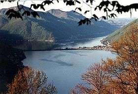
Monte San Giorgio, shown on the left in the background of Lake Lugano | |
| Highest point | |
| Elevation | 1,097 m (3,599 ft) |
| Prominence | 758 m (2,487 ft) [1] |
| Coordinates | 45°54′49″N 8°56′59″E / 45.91361°N 8.94972°ECoordinates: 45°54′49″N 8°56′59″E / 45.91361°N 8.94972°E |
| Geography | |
 Monte San Giorgio Location in Switzerland | |
| Location | Ticino, Switzerland |
| Parent range | Lugano Prealps |
| Topo map | Swisstopo 1373 Mendrisio |
| Climbing | |
| Easiest route | Trail |
| Official name | Monte San Giorgio |
| Type | Natural |
| Criteria | viii |
| Designated | 2003 (27th session) |
| Reference no. | 1090 |
| State Party | Switzerland-Italy |
| Region | Europe and North America |
| Extensions | 2010 |
Monte San Giorgio is a wooded mountain (1,097 m above sea level) of the Lugano Prealps, overlooking Lake Lugano in Switzerland. It lies in the southern part of the canton of Ticino, between the municipalities of Brusino Arsizio, Riva San Vitale and Meride. Monte San Giorgio became a UNESCO World Heritage Sites in 2003, because it "is the single best known record of marine life in the Triassic period, and records important remains of life on land as well."[2] The Italian region west of Poncione d'Arzo (Porto Ceresio) was added as an extension to the World Heritage Site in 2010.
In Meride is the Museum of fossils from Monte San Giorgio, designed by the Ticinese architect Mario Botta.
Notes and references
External links
 Media related to Monte San Giorgio at Wikimedia Commons
- Monte San Giorgio on Hikr
- World Heritage official website
World Heritage Sites in Switzerland | ||
|---|---|---|
| Lake Geneva region | ||
| Espace Mittelland | ||
| Eastern |
| |
| Ticino | ||
| Nationwide | ||

This article is issued from Wikipedia - version of the 1/26/2016. The text is available under the Creative Commons Attribution/Share Alike but additional terms may apply for the media files.