Montbronn
| Montbronn | ||
|---|---|---|
|
Village view. | ||
| ||
 Montbronn | ||
|
Location within Grand Est region  Montbronn | ||
| Coordinates: 48°59′42″N 7°18′38″E / 48.995°N 7.3106°ECoordinates: 48°59′42″N 7°18′38″E / 48.995°N 7.3106°E | ||
| Country | France | |
| Region | Grand Est | |
| Department | Moselle | |
| Arrondissement | Sarreguemines | |
| Canton | Bitche | |
| Intercommunality | Pays de Bitche | |
| Government | ||
| • Mayor (1977–2020) | Francis Sidot | |
| Area1 | 14.99 km2 (5.79 sq mi) | |
| Population (2013)2 | 1,653 | |
| • Density | 110/km2 (290/sq mi) | |
| Time zone | CET (UTC+1) | |
| • Summer (DST) | CEST (UTC+2) | |
| INSEE/Postal code | 57477 / 57415 | |
| Elevation |
238–381 m (781–1,250 ft) (avg. 360 m or 1,180 ft) | |
|
1 French Land Register data, which excludes lakes, ponds, glaciers > 1 km² (0.386 sq mi or 247 acres) and river estuaries. 2 Population without double counting: residents of multiple communes (e.g., students and military personnel) only counted once. | ||


Montbronn (German: Mombronn, Lorraine Franconian: Mumere) is a commune in the Moselle department of the Grand Est administrative region in north-eastern France.
The village belongs to the Pays de Bitche and to the Northern Vosges Regional Nature Park. As of the 2013 France census, the village's population is 1,653. The inhabitants of the commune are known as Montbronnois or Montbronnoises.
Geography
Location
Located east of the Moselle department, the commune is part of the Pays de Bitche; It borders the neighboring Bas-Rhin department, territory also known as the Alsace bossue.[1]
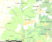
The village is located 11 kilometres (6.8 mi) south-west of Bitche, the county's chief town, 21.8 kilometres (13.5 mi) south-east of Sarreguemines, the arrondissement's subprefecture, about 83 kilometres (52 mi) east of Metz, the department's prefecture and about 56 kilometres (35 mi) north-west of Strasbourg, the region's prefecture.[2] Neighboring communes include Rahling to the west, Bining, Rohrbach-lès-Bitche and Enchenberg to the north, Saint-Louis-lès-Bitche and Meisenthal to the east, and Soucht to the south.[3]
Neighbouring communes and villages[4]
 |
Bining | Rohrbach-lès-Bitche | Enchenberg | |
| Rahling | |
Saint-Louis-lès-Bitche | ||
| ||||
| | ||||
| Butten, Ratzwiller | Soucht | Meisenthal |
Communications
Road network
The town is crossed from west to east (Main Street) by the D83 which connects Kalhausen to Enchenberg. This road crosses both the D110F and the D36A in the village, linking it to respectively Rohrbach-lès-Bitche and Lemberg. Thoses roads are later extended by several county roads. The nearest entrance to the Autoroute de L'Est (A4 autoroute) is via the D83 through the Sarre-Union interchange at Thal-Drulingen.[1] · [4]
Public transport
The Sarreguemines–Bitche railway line has passed through the neighboring commune of Enchenberg from 1869 to 2014. The railway line is now disused and has been replaced by a TER Lorraine bus line. Now the nearest SNCF station is at Diemeringen, commune served by the Sarreguemines–Strasbourg railway line.[5]
School buses to the Lemberg collège (middle school) and to the collèges and lycées (middle and high schools) of Bitche are available during school terms.[6]
Administration
Canton and intercommunality
Montbronn is one of 46 communes in the canton of Bitche. Its general counsels since the French legislative election of 2012 are Anne Mazuy-Harter (DVD) and David Suck (UDI).[7]
The town is part of the Pays de Bitche community of communes (French: Communauté de communes du Pays de Bitche) which includes 37 of the 46 communes in the canton. This grouping is headed by Francis Vogt, municipal counsel of Bitche.[3] · [8]
List of successive mayors
| From | To | Name | Party | Position |
|---|---|---|---|---|
| 1977 | 2020 | Francis Sidot | independent |
(Not all data is known)
Population
In 2013 the commune had 1,653 inhabitants. The evolution of the number of inhabitants is known through the population censuses conducted in the town since 1793. From the 21st century, a census of municipalities with fewer than 10,000 inhabitants is held every five years, unlike larger towns that have a sample survey every year.[Note 1]
| 1793 | 1800 | 1806 | 1821 | 1836 | 1841 | 1861 | 1866 | 1871 |
|---|---|---|---|---|---|---|---|---|
| 960 | 959 | 1,323 | 1,500 | 1,595 | 1,711 | 1,739 | 1,708 | 1,618 |
| 1875 | 1880 | 1885 | 1890 | 1895 | 1900 | 1905 | 1910 | 1921 |
|---|---|---|---|---|---|---|---|---|
| 1,533 | 1,430 | 1,486 | 1,538 | 1,612 | 1,623 | 1,742 | 1,757 | 1,652 |
| 1926 | 1931 | 1936 | 1946 | 1954 | 1962 | 1968 | 1975 | 1982 |
|---|---|---|---|---|---|---|---|---|
| 1,657 | 1,643 | 1,673 | 1,627 | 1,540 | 1,649 | 1,755 | 1,791 | 1,743 |
| 1990 | 1999 | 2008 | 2013 | - | - | - | - | - |
|---|---|---|---|---|---|---|---|---|
| 1,698 | 1,668 | 1,672 | 1,653 | - | - | - | - | - |
Sources : Ldh/EHESS/Cassini until 1962, INSEE database from 1968 (population without double counting and municipal population from 2006) · [9]

Local life
Language
The majority of the inhabitants can speak and/or understand German and also speak French. The local dialect is known as Lorraine Franconian. Lorraine Franconian is a dialect of German that has been spoken and developed in the region for over a thousand years.[10]
Education
Montbronn depends on the Academy of Nancy-Metz.
The village is provided with a preschool (French: école maternelle) and a primary school (French: école primaire).[11]
Studies then go on at the collège La Paraison in Lemberg. To continue their studies in high school, young Montbronnois mainly go to Bitche or Sarreguemines.
Health
Two general practitioners reside in Montbronn. Thus, both a medical home and a pharmacy are located in the village. As for hospitals, they are located in Bitche, Ingwiller, Sarreguemines, Saverne, Haguenau and Strasbourg.[12] · [13] · [14] · [15]
See also
Bibliography
- Beck, Joël (1988). Rohrbach-lès-Bitche et son canton (in French).
- Beck, Joël (1999). Les moulins et scieries du Pays de Bitche (in French).
- Beck, Joël (2004). Le canton de Rohrbach-lès-Bitche (in French).
- Beck, Joël (2005). Le Pays de Bitche 1900-1939 (in French). p. 128.
- Conrad, Joseph (2000). Les habitants de Montbronn (in French).
- Glath, Paul-Édouard (1997). Du pays de Bitche en Charente-Maritime : Souvenirs de 1939-40 (in French). p. 94.
- Hemmert, Didier (1998). Le Pays de Bitche (in French).
- Kochert, Francis; Michaux, Laurette; Michaux, Gérard (2008). Moselle : Metz et le pays messin, pays de Bitche, Nied, Sarrebourg, Saulnois, trois frontières et bassin houiller (in French). p. 345.
- Mazerang, Albert (2013). Les cloches de Montbronn (in French).
- Charpentier, Nöelle-Vix (2011). Plan local d'urbanisme de Montbronn [Rapport de présentation] (PDF) (in French). Metz. p. 120.
- Schaefer, Joseph (2004). Le Pays de Bitche, passionnément (in French). p. 174.
- Schutz, André (1992). Bitche et son pays (in French).
Related articles
External links
| Wikimedia Commons has media related to Montbronn. |
- "Montbronn". bitscherland.fr (in French).
- "Montbronn". geneawiki.com (in French).
Notes and references
Notes
- ↑ At the beginning of the 21st century, the methods of identification have been modified by law No. 2002-276 of 27 February 2002 , the so-called "law of local democracy" and in particular Title V "census operations" which allow, after a transitional period running from 2004 to 2008, the annual publication of the legal population of the different French administrative districts. For municipalities with a population greater than 10,000 inhabitants, a sample survey is conducted annually, the entire territory of these municipalities is taken into account at the end of the period of five years. The first "legal population" after 1999 under this new law came into force on 1 January 2009 and was based on the census of 2006.
References
- 1 2 (Charpentier 2011, p. 9).
- ↑ "Orthodromy". Lion1906 from Lionel Delvarre. Retrieved 21 March 2016.
- 1 2 (Charpentier 2011, p. 11).
- 1 2 Google Maps
- ↑ "TER Lorraine". SNCF's website. Retrieved 21 March 2016.
- ↑ "School buses". cg57.fr. Retrieved 21 March 2016.
- ↑ "County Council". moselle.fr. Retrieved 21 March 2016.
- ↑ "The community of communes's elected representatives". Pays de Bitche community of communes's website. Retrieved 21 March 2016.
- ↑ Census of population on 1 January 2006 on the site of Insee.
- ↑ S. Legrand - according to the INSEE's numbers.
- ↑ "Montbronn's public preschool". education.gouv.fr. Retrieved 7 May 2016.
- ↑ "Montbronn's general practitioners". doctolib.fr. Retrieved 18 May 2016.
- ↑ "The Montbronn medical home's opening". republicain-lorrain.fr. Retrieved 18 May 2016.
- ↑ "Montbronn's pharmacy". Pages Jaunes's website. Retrieved 18 May 2016.
- ↑ "Nearest hospitals from Montbronn". medecin-360.fr. Retrieved 18 May 2016.