Montaione
| Montaione | ||
|---|---|---|
| Comune | ||
| Comune di Montaione | ||
|
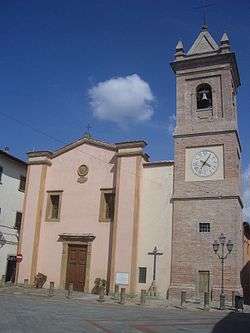
Church of San Regolo. | ||
| ||
 Montaione Location of Montaione in Italy | ||
| Coordinates: 43°33′12″N 10°54′42″E / 43.55333°N 10.91167°ECoordinates: 43°33′12″N 10°54′42″E / 43.55333°N 10.91167°E | ||
| Country | Italy | |
| Region | Toscana | |
| Province / Metropolitan city | Florence (FI) | |
| Frazioni | Barbialla, Casetta, Castelfalfi, Collegalli, Filicaja, Alberi, Iano, Sughera, Mura, Olmo, Palagio, Piaggia, Santo Stefano, San Vivaldo, Tonda, Vignale | |
| Government | ||
| • Mayor | Paola Rossetti in Benassi | |
| Area | ||
| • Total | 104.8 km2 (40.5 sq mi) | |
| Elevation | 342 m (1,122 ft) | |
| Population (1 January 2007)[1] | ||
| • Total | 3,667 | |
| • Density | 35/km2 (91/sq mi) | |
| Demonym(s) | Montaionesi | |
| Time zone | CET (UTC+1) | |
| • Summer (DST) | CEST (UTC+2) | |
| Postal code | 50050 | |
| Dialing code | 0571 | |
| Saint day | May 3 | |
| Website | Official website | |

Montaione is a comune (municipality) in the Province of Florence in the Italian region Tuscany, located about 35 kilometres (22 mi) southwest of Florence.
Geography
The frazione of Filicaja that is famous as the starting point of Antonio da Filicaja for the invasion of Pisa by the Florentine army in 1509.
Main sights
- The church of San Ragolo houses the Madonna del Buonconsiglio by Guido da Graziano (late 13th century)
- Church and convent of San Vivaldo. The church has works attributed to Giovanni della Robbia, Benedetto Buglioni, Raffaellino del Garbo and Andrea Sansovino
- Castles include those of:
- Iano
- Camporena, destroyed by the Florentines in 1329.
- Vignale
- Collegalli, now a patrician villa
- Figline, known from the 12th century. It is owned by the Filicaja family.
- Barbialla, owned in the Middle Aged by the Cadolingians and the della Gherardesca families, then by the bishops of Volterra, the commune of San Miniato, the Republic of Florence and the Republic of Pisa.
- Castelfafi, allegedly founded by the Lombards in the 8th century. It was a possession of the della Gherardesca and then of the bishops of Volterra. Later it was acquired by the Caetani. In 1554 it was sacked by the troops of Piero Strozzi.
- Tonda
- Sughera
- Scopeto
- Santo Stefano
Animal sanctuaries
The Italian Horse Protection Association (IHP) has its main base in Montaione's frazione of Filicaja.[2]
References
- ↑ All demographics and other statistics: Italian statistical institute Istat
- ↑ Where we are - IHP internet site
External links
| Wikimedia Commons has media related to Montaione. |
This article is issued from Wikipedia - version of the 1/31/2015. The text is available under the Creative Commons Attribution/Share Alike but additional terms may apply for the media files.