Mont Puget
| Mont Puget | |
|---|---|
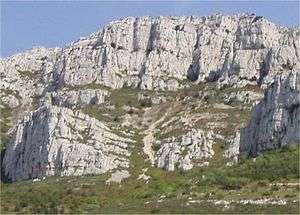
 Mont Puget from the Luminy University campus | |
| Highest point | |
| Elevation | 563 m (1,847 ft) |
| Coordinates | 43°13′19″N 05°27′31″E / 43.22194°N 5.45861°ECoordinates: 43°13′19″N 05°27′31″E / 43.22194°N 5.45861°E |
| Geography | |
 Mont Puget France | |
| Location | Bouches-du-Rhône, France |
| Parent range | Calanques de Marseille |
| Geology | |
| Mountain type | Limestone |
Mont Puget, named after the French sculptor Pierre Puget, is a mountain, part of Marseille-Cassis calanques, located south-east of Marseille. Like most Marseille mountains, it is formed from limestone.
Tourism
Often neglected by tourists, much interested by the Calanques themselves and by the sea, the Mont Puget can provide for some interesting hiking and climbing.
A very good trail leads to the very top of the mountain (like on most of Marseille mountain ranges, so that firefighters can get everywhere should a fire start).
However, one can also climb the mountain directly, which can provide for many interesting experiences.
One of them are "stone rivers", or collections of numerous small stones "flowing" from the mountain at angles reaching 45 degrees.
The top of the mountain is covered with eroded limestone that sticks out in numerous needle-like spikes.
Crest of Luminy University
A stylized representation of Mont Puget is displayed on the crest of Luminy Faculty of Sciences, part of the University of the Mediterranean Aix-Marseille II. The Luminy campus is located 1 km northwest of Mont Puget.
References
- Marseille Tourism Office Information
- French Nationan Geographic Institute maps (for altitude figure)
External links
- Le massif des Calanques
- A satellite view of Mont Puget the city and the university campus are on the left, the road at the top is Marseille-Cassis road (the Gineste).