Monson, Massachusetts
| Monson, Massachusetts | ||
|---|---|---|
| Town | ||
|
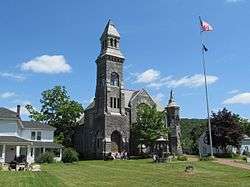
Memorial Hall | ||
| ||
 Location in Hampden County in Massachusetts | ||
| Coordinates: 42°06′15″N 72°19′10″W / 42.10417°N 72.31944°WCoordinates: 42°06′15″N 72°19′10″W / 42.10417°N 72.31944°W | ||
| Country | United States | |
| State | Massachusetts | |
| County | Hampden | |
| Settled | 1715 | |
| Incorporated | 1775 | |
| Government | ||
| • Type | Open town meeting | |
| • Board of Selectmen |
Dr. Richard M. Smith (chairman), Edward S. Harrison, and Edward A. Maia | |
| Area | ||
| • Total | 44.8 sq mi (116.1 km2) | |
| • Land | 44.3 sq mi (114.7 km2) | |
| • Water | 0.5 sq mi (1.4 km2) | |
| Elevation | 407 ft (124 m) | |
| Population (2010) | ||
| • Total | 8,560 | |
| • Density | 193.2/sq mi (74.6/km2) | |
| Time zone | Eastern (UTC-5) | |
| • Summer (DST) | Eastern (UTC-4) | |
| ZIP code | 01057 | |
| Area code(s) | 413 | |
| FIPS code | 25-42145 | |
| GNIS feature ID | 0618188 | |
| Website | http://www.monson-ma.gov/ | |

Monson /ˈmʌnsən/ is a town in Hampden County, Massachusetts, United States. The population was 8,560 at the 2010 census. It is part of the Springfield, Massachusetts Metropolitan Statistical Area.
The CDP of Monson Center lies at the center of the town.
History
The first colonist to settle in present-day Monson was Richard Fellows, who in 1657 was granted 200 acres of land by the Massachusetts General Court. He built a tavern along the Bay Path, which was the primary route from Springfield to Boston, and which ran through the northern part of Monson. It was the first house built between Springfield and Brookfield, but the tavern was short-lived; within a year or two, Fellows abandoned it for fear of attacks from local Native Americans.[1]
The first permanent settlers arrived in 1715, and in 1735 the town of Brimfield was incorporated, and included present-day Monson within its boundaries. The eastern part of the town later separated, and was incorporated as the town of Monson in 1775. The town was named after Sir John Monson, president of the British Board of Trade and a friend of Massachusetts governor Thomas Pownall.[2]
In the 19th century and early 20th century, mills were built along the Chicopee Brook, which runs south to north through the center of the town. One of the most successful industries during this time was the woolen mills, which were operated by industrialists such as Joseph L. Reynolds, Dwight W. Ellis, C. W. Holmes, and S. F. Cushman. In addition, Heiman & Lichten operated a successful straw and felt goods factory on Main Street.[1]
Monson was also known for its granite quarries; the first quarry was opened in 1809, east of present-day Margaret Street. It was used for a short time by the federal government to supply stone for the Springfield Armory, and was later sold to Rufus Flynt, who opened a commercial quarry on the site in 1825 with five employees. By 1900, the quarry was operating under the name of W.N. Flynt Granite Co., and had expanded to almost 500 employees.[1] The quarry continued in operation until about 1935.
On June 1, 2011, an EF3 tornado crossed through the center of the town, causing $11.9 million in property damage, which included 238 damaged buildings,[3] 77 of which were damaged beyond repair.[4] Several town landmarks were damaged or destroyed: the First Church of Monson and the Unitarian Universalist Church buildings each lost their steeple, the historic 1900 Holmes Gymnasium, once part of Monson Academy, was destroyed, and the town office building, built in 1925 as the first Monson High School, was damaged beyond repair and demolished in 2013.
Geography
According to the United States Census Bureau, the town has a total area of 44.8 square miles (116 km2), 44.3 square miles (115 km2) of which is land and 0.5 square miles (1.3 km2) of which is water.
Monson is bordered on the north by Palmer, on the east by Brimfield and Wales, on the south by Stafford, Connecticut and on the west by Hampden and Wilbraham.
Demographics
| Historical population | ||
|---|---|---|
| Year | Pop. | ±% |
| 1850 | 2,831 | — |
| 1860 | 3,164 | +11.8% |
| 1870 | 3,204 | +1.3% |
| 1880 | 3,758 | +17.3% |
| 1890 | 3,650 | −2.9% |
| 1900 | 3,402 | −6.8% |
| 1910 | 4,758 | +39.9% |
| 1920 | 4,826 | +1.4% |
| 1930 | 4,918 | +1.9% |
| 1940 | 5,597 | +13.8% |
| 1950 | 6,125 | +9.4% |
| 1960 | 6,712 | +9.6% |
| 1970 | 7,355 | +9.6% |
| 1980 | 7,315 | −0.5% |
| 1990 | 7,776 | +6.3% |
| 2000 | 8,359 | +7.5% |
| 2010 | 8,560 | +2.4% |
| * = population estimate. Source: United States Census records and Population Estimates Program data.[5][6][7][8][9][10][11][12][13][14] | ||
As of the census[15] of 2000, there were 8,359 people, 3,095 households, and 2,203 families residing in the town. The population density was 188.8 people per square mile (72.9/km²). There were 3,213 housing units at an average density of 72.6 per square mile (28.0/km²). The racial makeup of the town was 97.69% White, 0.67% African American, 0.23% Native American, 0.31% Asian, 0.01% Pacific Islander, 0.23% from other races, and 0.86% from two or more races. Hispanic or Latino of any race were 1.17% of the population.
There were 3,095 households out of which 34.2% had children under the age of 18 living with them, 57.9% were married couples living together, 9.4% had a female householder with no husband present, and 28.8% were non-families. 22.8% of all households were made up of individuals and 9.1% had someone living alone who was 65 years of age or older. The average household size was 2.63 and the average family size was 3.12.
In the town the population was spread out with 25.2% under the age of 18, 6.7% from 18 to 24, 31.3% from 25 to 44, 25.8% from 45 to 64, and 10.9% who were 65 years of age or older. The median age was 38 years. For every 100 females there were 97.4 males. For every 100 females age 18 and over, there were 95.5 males.
The median income for a household in the town was $52,030, and the median income for a family was $58,607. Males had a median income of $41,373 versus $30,545 for females. The per capita income for the town was $22,519. About 5.2% of families and 5.6% of the population were below the poverty line, including 6.8% of those under age 18 and 3.7% of those age 65 or over.
Education
The town of Monson has three public schools: Quarry Hill Community School for grades preschool through fourth; Granite Valley Middle School for grades five through eight; and Monson High School for grades nine through twelve. As of the 2012-2013 school year, 1,255 students collectively are enrolled in the Monson Public Schools.[16]
The town of Monson was formerly the site of Monson Academy, a private school that was founded in 1804 and opened in 1806. In 1847, the academy became the first American school to enroll Chinese students. Among its graduates were abolitionist and suffragist Lucy Stone, and two United States Supreme Court justices: William Strong and Henry Billings Brown. Notable faculty members included US Secretary of Labor Frances Perkins, and Louise Torrey Taft, the mother of President William Howard Taft. In 1971, the academy merged with Wilbraham Academy to form Wilbraham & Monson Academy.[17]
Transportation
Two numbered highways pass through Monson: Massachusetts Route 32, which enters Monson from Connecticut, forms Main Street in the downtown area, and is the main north-south thoroughfare in the town. US Route 20 forms part of the northern border with Palmer, and also cuts across the extreme northeastern corner of the town.
The New England Central Railroad passes north-south through the town, roughly parallel to Route 32. No passenger service is available. The Boston & Albany Railroad line, now operated by CSX, travels across the northwestern part of the town.
Notable people
- Allan Bérubé (1946–2007), historian, activist, and author
- Samuel Robbins Brown (1810–1880), missionary
- George Stewart Miller (1884–1971), educator
- Effie Maud Aldrich Morrison, instigator for the plan of the first senior housing project
- Arthur D. Norcross (1848–1916), musician and politician
- Erasmus D. Peck (1808–1876), Congressman
- Albert G. Riddle (1816–1902), Congressman
- Sal Salvador (1928–1999), jazz musician
- Eliphalet Trask (1806-1890), Lieutenant Governor of Massachusetts
- Henry Martin Tupper (1831–1893), minister and educator
- William L. Utley (1814-1887), military officer and politician
- Kelly Dempsey (1983-), fashion designer
Notable places and mills
- Conant Brook Dam
- First Church of Monson
- W.N. Flynt Granite Co.
- Memorial Town Hall
- Monson High School
- Peaked Mountain
- William Norcross House
- Omega Metal Processing
- S. F. Cushman Woolen Mill
- Tree House Brewing Company
See also
References
- 1 2 3 Copeland, Alfred Minott (1902). "Our County and Its People": A History of Hampden County, Massachusetts.
- ↑ "Profile for Monson, Massachusetts". ePodunk. Retrieved 2010-05-07.
- ↑ Appleton, John (June 30, 2011). "Monson tornado debris cleanup expenses top $3.4 million". masslive.com. Retrieved April 7, 2016.
- ↑ Barnes, George; Bock, Linda; Croteau, Scott J.; Kievra, Bob (June 30, 2011). "Damage assessment". telegram.com. Retrieved April 7, 2016.
- ↑ "TOTAL POPULATION (P1), 2010 Census Summary File 1". American FactFinder, All County Subdivisions within Massachusetts. United States Census Bureau. 2010.
- ↑ "Massachusetts by Place and County Subdivision - GCT-T1. Population Estimates". United States Census Bureau. Retrieved July 12, 2011.
- ↑ "1990 Census of Population, General Population Characteristics: Massachusetts" (PDF). US Census Bureau. December 1990. Table 76: General Characteristics of Persons, Households, and Families: 1990. 1990 CP-1-23. Retrieved July 12, 2011.
- ↑ "1980 Census of the Population, Number of Inhabitants: Massachusetts" (PDF). US Census Bureau. December 1981. Table 4. Populations of County Subdivisions: 1960 to 1980. PC80-1-A23. Retrieved July 12, 2011.
- ↑ "1950 Census of Population" (PDF). Bureau of the Census. 1952. Section 6, Pages 21-10 and 21-11, Massachusetts Table 6. Population of Counties by Minor Civil Divisions: 1930 to 1950. Retrieved July 12, 2011.
- ↑ "1920 Census of Population" (PDF). Bureau of the Census. Number of Inhabitants, by Counties and Minor Civil Divisions. Pages 21-5 through 21-7. Massachusetts Table 2. Population of Counties by Minor Civil Divisions: 1920, 1910, and 1920. Retrieved July 12, 2011.
- ↑ "1890 Census of the Population" (PDF). Department of the Interior, Census Office. Pages 179 through 182. Massachusetts Table 5. Population of States and Territories by Minor Civil Divisions: 1880 and 1890. Retrieved July 12, 2011.
- ↑ "1870 Census of the Population" (PDF). Department of the Interior, Census Office. 1872. Pages 217 through 220. Table IX. Population of Minor Civil Divisions, &c. Massachusetts. Retrieved July 12, 2011.
- ↑ "1860 Census" (PDF). Department of the Interior, Census Office. 1864. Pages 220 through 226. State of Massachusetts Table No. 3. Populations of Cities, Towns, &c. Retrieved July 12, 2011.
- ↑ "1850 Census" (PDF). Department of the Interior, Census Office. 1854. Pages 338 through 393. Populations of Cities, Towns, &c. Retrieved July 12, 2011.
- ↑ "American FactFinder". United States Census Bureau. Retrieved 2008-01-31.
- ↑ "Monson Public Schools". Retrieved 2013-10-12.
- ↑ "Monson Academy". Monson Historical Society. Retrieved 2013-10-12.
External links
| Wikimedia Commons has media related to Monson, Massachusetts. |
Municipalities and communities of Hampden County, Massachusetts, United States | ||
|---|---|---|
| Cities | 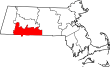 | |
| Towns | ||
| CDPs | ||
| Other villages | ||
| Footnotes | ‡This populated place also has portions in an adjacent county or counties | |