Moggill, Queensland
| Moggill Brisbane, Queensland | |||||||||||||
|---|---|---|---|---|---|---|---|---|---|---|---|---|---|
 Moggill | |||||||||||||
| Coordinates | 27°35′S 152°52′E / 27.583°S 152.867°ECoordinates: 27°35′S 152°52′E / 27.583°S 152.867°E | ||||||||||||
| Population | 3,606 (2011 census)[1] | ||||||||||||
| Postcode(s) | 4070 | ||||||||||||
| Location | 19 km (12 mi) from Brisbane GPO | ||||||||||||
| LGA(s) | City of Brisbane | ||||||||||||
| State electorate(s) | Moggill | ||||||||||||
| Federal Division(s) | Ryan | ||||||||||||
| |||||||||||||
Moggill is a suburb in the west of the City of Brisbane, Queensland, Australia.[2] It is about 19 kilometres (12 mi) from the Brisbane CBD. It comprises a mixture of small-lot and acreage residential homes along with a small number of remaining farms. Moggill is located in the Parish of Moggill[3] within the County of Stanley, Queensland.
History
The Brisbane River and Moggill Creek were rich in resources and evidence of Aboriginal occupation includes Bora grounds near the Moggill Pony Club and O'Brien Road. Another Bora ring is located at the end of Riversleigh Road.
John Oxley the first European visitor, named it Termination Plains when he landed in the Priors Pocket area in 1823.[4] In 1848 a profitable coal mine owned by John Williams commenced operation.[5] The first survey of Moggill was in 1851, with a township planned in the vicinity of Weekes Rd, however it was later established near the present school. A cemetery was established in 1865. The Moggill State School opened a year later starting as a two-room schoolhouse and remaining that way until 1970 when the population of the area started expanding rapidly.
At about this time Moggill was divided into three suburbs, the other two were named Anstead and Bellbowrie. The name of the creek is derived from 'Magil', from Yuggera (Jagera) Nation language meaning water dragon.[2]
After 2004, the traditional Moggill pineapple farms, situated on the rich red clay soils around Witty Road and Priors Pocket Road, began to be subdivided for housing. There was vocal opposition to the subdivision from Moggill residents, who wished to preserve the rural amenity of the area with larger block sizes. In spite of this, the average block size of the new estates is around 700 m².
Local government administration
Moggill has been administered by six local government entities:[6][7]
- Ipswich-Bundamba between 1876 and 1878 (Qld Electoral Rolls 1860-1884)
- Toowong Division between 1879 and 1880;
- Indooroopilly Division between 2 June 1880 and 31 March 1903;
- Indooroopilly Shire between 31 March 1903 and 8 December 1917;
- Moggill Shire between 8 December 1917 and 1 October 1925 and
- Brisbane City Council from 1 October 1925.
Demographics
In the 2011 census, Moggill recorded a population of 3,606 people; 51.1% female and 48.9% male.
The median age of the Moggill population was 34 years of age, 3 years below the Australian median. Children aged under 15 years made up 27.2% of the population and people aged 65 years and over made up 9.1% of the population.
67.1% of people living in Moggill were born in Australia, similar to the national average of 69.8%; the next most common countries of birth were England 7.3%, South Africa 5.8%, New Zealand 3.6%, India 1.4%, Zimbabwe 0.9%.
86.3% of people spoke only English at home; the next most popular languages were 1.7% Afrikaans, 0.9% Sinhalese, 0.9% Mandarin, 0.7% Spanish, 0.6% Korean.
The most common religious affiliation was "No Religion" 25.9%; the next most common responses were Catholic 24.1%, Anglican 18.5%, Uniting Church 6.7% and "Christian, nfd" 4.1%.[1]
Education
Schools
Moggill State Primary School, located at 3417 Moggill Road, offers primary education between Preparatory Year to Grade 7.[8] The school celebrated its sesquicentenary (150th anniversary) on 12 February 2016.[9] Kenmore State High School, located at Aberfeldy Street, Kenmore, which offers secondary education between Grades 8 to 12, contains Moggill within its catchment area.[10][11]
Emergency services
Police
Moggill is within the Brisbane West District of the Metropolitan North Region[12] of the Queensland Police Service. The Bellbowire Neighbourhood Police Beat, located at 5 Westaway Crescent, Bellbowrie,[13] provides Moggill with an effective policing presence in an urban situation.[14] The nearest police station within the Metropolitan North Region is Indooroopilly Police Station.[15] Ignoring the established District, police stations closer than Indooroopilly are Karana Downs Station, Goodna Station and Mount Ommaney Station.[16]
Medical
The Queensland Ambulance Service provide emergency care and transport services for Moggill residents. Funding was allocated within the Queensland Government's 2010-11 State Budget for the initial planning stage of a new ambulance station at Pinjarra Hills[17] which will be equipped with multiple ambulances and first responders.[18] The Pinjarra Hills ambulance station will be the closest but not the only ambulance station caring for Moggill residents.
Fire and rescue
Moggill is located within the City West Command of the Brisbane Region of the Queensland Fire and Rescue Service. In May 2010 construction commenced on a new fire station, located at 6 Pullenvale Road, Pullenvale, to replace the Kenmore Fire Station.[19][20] The Pullenvale fire station will be the closest but not the only fire station serving Moggill residents.
Evacuation centre
During the 2011 Brisbane River flood the Uniting Church, corner Moggill and Kangaroo Gully Roads, was used as an unofficial evacuation centre.[21][22]
Water

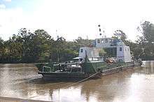
Moggill Ferry, a tolled vehicular cable ferry, crosses the Brisbane River between Moggill Road, Moggill, and Moggill Ferry Road, Riverview. The ferry was motorised in the 1940s under the joint control of the Ipswich and Brisbane City Councils. As of 2010, the service is provided by Stradbroke Ferries Ltd. The communities on either side of the Brisbane River have for a long time been divided on the topic of replacing the ferry service with a bridge. Naysayers concerns include: the ferry is historical; the rural lifestyle on the north side of the river will be replaced with urban sprawl; Moggill Road already suffers from congestion; and the cost would be too great. Yeasayers concerns include: there is a lack of alternative convenient river crossings (nearest are Colleges Crossing and Jindalee); the ferry does not operate at night; sporadic halts to service occur due to mechanical breakdowns; and severe weather causes dangerous river debris and strong river currents.[23] The ferry is free for pedestrians and bicycles.
During the 2011 Brisbane River flood, the service was suspended and the ferry secured on the western bank. On 12 January 2011, when the river reached the peak of 18 metres its force broke one of its 2 cables. An assessment was made as to whether to sink, demolish or secure the ferry to prevent it becoming a 'missile' downstream if it came free. A decision was made to further secure it with a 1.5 tonne anchor, which was flown in by helicopter.[24]
Road
Utilising Moggill Road, State Route 33, Brisbane via Toowong, Indooroopilly and Bellbowrie to Riverview, bisects Moggill. It has both a single and dual carriageway within Moggill.[25]
An alternative location for a bridge to replace Moggill Ferry is proposed within the Moggill Pocket Arterial Road Transport Corridor. Land has been set aside by the Queensland government as a future transport corridor passing through the suburbs of Kenmore, Pullenvale, Anstead and Karalee to connect the Centenary Highway at Fig Tree Pocket with the Warrego Highway at North Tivoli.[26]
On 15 February 2011, the Brisbane Times reported that the Queensland government were re-evaluating the possibility of constructing a bridge over the Brisbane River.[27]
The Kenmore Bypass is a proposed regional motorway designed to relieve congestion on the Ipswich Motorway. In 2010, land acquisitions commenced within the Federally funded Nation Building Program as a National Project to create a future transport corridor. The transport corridor passes through the suburbs of Riverview, Redbank, Moggill (including Priors Pocket) and Wacol. Essentially, the bypass will connect the Warrego and Cunningham Highways in the west with the Logan and Ipswich Motorways in the east. There will be four Brisbane River crossings.[28][29] It is unlikely local traffic on and off-ramp access to the bypass will be provided. As of 2010, there is no date or funding provided to commence the construction of the Kenmore Bypass.
Bus
Brisbane Transport operate two bus services, routes P443 and 444, under the TransLink integrated public transport scheme. Both services connect Moggill, via Moggill Road and Coronation Drive, with King George Square busway station. Route 444 carries on across Brisbane River to the Cultural Centre busway station, South Brisbane. Route P443 is an express service between Chapel Hill and Roma Street busway station.[30]
There is no bus service to both Ipswich CBD, a major commercial and industrial area approximately 12 kilometres (7.5 mi) away, and the City of Ipswich Local Government Area which is on the other side of the Brisbane River.
Taxicab
The Council Cab and Karana Downs Personalised Public Transport (PPT) services are provided by Brisbane City Council. The Council Cab is offered to a pre-defined list of residents who find it difficult to get to their local shops.[31] The Karana Downs PPT services areas where TransLink services are restricted with Black and White Cabs providing wheelchair accessible and air conditioned maxi-cabs. The Karana Downs PPT is a hail and ride service with a fixed route, within Moggill it is along Kangaroo Gully and Moggill Roads (including Moggill State School).[32]
Black & White Cabs and Yellow Cabs provide commercial taxicab services for Moggill within the Metropolitan Taxi District of Brisbane.[33]
Public libraries
Brisbane City Council provides a mobile library service every Thursday at Bellbowrie Shopping Plaza, Bellbowrie.[34] The nearest Brisbane City Council branch public library is Kenmore Library, located within Kenmore Village Shopping Centre, Kenmore.[35]
Utilities
Water
Water is sourced from the SEQ Water Grid.[36]
Since November 2009, the supply of water to Moggill has been managed by Queensland Urban Utilities when it took over the Water Retail and Water Distribution business units of Brisbane City Council.[37][38] Moggill residents are affected by steep increases to the Bulk Water Prices that are set by the Queensland Water Commission.[39] In August 2008, the Queensland Water Commission published a forward estimate audit table outlining Bulk Water Prices for every year from 2007/2008 until 2017/2018: the Brisbane City Council Bulk Water Prices in 2007/2008 was $628/ML, by 2017/2018 it is estimated to be $2,755 per ML.[40] In September 2010, there has been much political debate relating to future Bulk Water Prices.[41][42][43]
The Queensland Water Commission decision to introduce permanent water conservation measures on 1 December 2009 is designed to encourage suburbs, including Moggill, to continue to use less than 200 litres per person per day (as well as other measures).[44]
Wastewater
Wastewater from Moggill is pumped across the Brisbane River to the Wacol Wastewater Treatment Plant (WWTP) located in Grindle Road, Wacol.[45]
From July 2010, Queensland Urban Utilities took over the management of Brisbane City Council's sewerage catchment system, which includes Moggill. Brisbane City Council is a joint owner of Queensland Urban Utilities.[46]
In 2009, when Brisbane City Council still managed the sewerage catchment system, the Council published a need for a New Sewerage Transportation Infrastructure due to local population increases resulting in sewerage catchment growth. The Council's preferred augmentation works involve "developing a greenfield sewerage system in Moggill and Bellbowrie" with 10 pumping stations that connect to Wacol WWTP being switched off.[47]
The likelihood of a greenfield sewerage system in Moggill and Bellbowrie in the foreseeable future is slim when considering the capacity of the Wacol WWTP is 8.4 ML per day but it is only treating 4 ML per day.[48] If Queensland Urban Utilities adopted a Brisbane City Council treatment capacity strategy, its implementation will result in Wacol WWTP being able to treat 12 ML per day to meet ultimate flows from the catchment, which Moggill plays a small part in.[47] Treated water from Wacol WWTP is transported to the Bundamba Advanced Water Treatment Plant (AWTP), which is part of the Western Corridor Recycled Water Scheme. Bundamba AWTP also sources water from the Bundamba, Goodna and Oxley WWTPs.[49] The Bundamba AWTP has a capacity to produce up to 66 ML per day of treated water[50] and by 2009 it was receiving a total of 61.6 ML per day,[48] it was operating at 93.3% capacity. The Brisbane City Council treatment capacity strategy (mentioned above) had plans for Oxley WWTP to increases capacity from the existing 42.5 ML per day to 65 ML per day then to 90 ML per day to meet the ultimate flows from the catchment,[47] representing an additional 47.5 ML per day beyond its 2009 capacity. Increasing the capacity of Oxley WWTP will also require expensive capacity upgrades to Bundamba AWTP. A greenfield sewerage system in Moggill and Bellbowrie is unlikely any time soon.
Electricity
Moggill is located within the South East Queensland electricity distribution network owned and operated by Energex.[51] From July 2007, Moggill residents and businesses were able to choose their electricity retailer due to the commencement of competition.[52]
Community groups
Moggill Historical Society was formed in 2013 to research, preserve and promote the history and heritage of the Moggill district including the Brisbane suburbs of Anstead, Bellbowrie, Pullenvale and Pinjarra Hills.
Sport clubs
No sport clubs are located in Moggill. Due to the history of the Moggill area, there are several sports clubs that use the town's name in their title, they are located in neighbouring Bellbowrie and nearby Pullenvale. These include the Moggill Football Club and Moggill Cricket Club both situated at the Bellbowrie Sports and Recreation Club.
The former Moggill Country Club, established in the 1960s, was a privately owned golf course and club that was located at the eastern end of Weekes Road. In 2010, the land was described as "an overgrown paddock"[53] and an application was submitted to Brisbane City Council to sub-divide the land into 93 residential lots (development concept on-going since 2004).[54] The Country Club was, up until its closure, one of the oldest sporting and social clubs in the area.
Sport fields
In 2010, Brisbane City Council used the local print media to communicate a draft concept plan for a future Moggill District Sports Park[55] to be located along Moggill Road on Council acquired land.[56] The draft concept plan envisaged the District Sports Park will have facilities and change rooms to cater for several sports:
- 1 Rugby League/Union senior field;
- 1 Rugby League/Union junior area;
- 4 Netball courts;
- 4 Tennis courts;
- 1 Cricket oval (including nets) and
- 1 Australian Football oval.
The District Sports Park is planned for multiple uses with the layout changing depending on the sport seasons.
In 2010, a cricket oval was constructed on the corner of Moggill and Priors Pocket Roads as part of a residential housing subdivision known as The Pitch.[57]
Parks
Only one park within Moggill has facilities including a playground, barbecue & shelter but no toilets: Moggill Ferry Reserve, Moggill Road, next to Moggill Ferry.
Other parks within Moggill are:
- Aitcheson Street (no.5-6), Aitcheson Street (East), adjoining Brisbane River;
- Aitcheson Street (no.101), Aitcheson Street(West), adjoining Brisbane River;
- Sheldrake Place & Weekes Road;
- Ellerby Road, adjoining Brisbane River;
- Livesay Road, Beaufort Crescent and Forestwood and Livesay Roads;
- Moggill Road (no.3777), Aitcheson Street and Moggill Road;
- Myora Street, Hawkesbury Road and Myora Street;
- Priors Pocket Road (no.301), Priors Pocket Road;[58]
- Priors Pocket Road, Priors Pocket Road, adjoining Brisbane River and
- Stratford Street, Stratford and Avonmore Streets, on the Brisbane River.[59]
No parks within Moggill have toilet facilities, the two closest Brisbane City Council parks that do are located at: Booker Place Park, Birkin Road, Bellbowrie[60] and on the intersection of Hawkesbury & Mt Crosby Roads, Anstead.[61]
The majority of land that sits between the adjoining Brisbane River and private properties is classified as Park Land (PK) by Brisbane City Council.[62]
References
- 1 2 Australian Bureau of Statistics (31 October 2012). "Moggill (State Suburb)". 2011 Census QuickStats. Retrieved 23 August 2014.
- 1 2 "Moggill (entry 41507)". Queensland Place Names. Queensland Government. Retrieved 28 August 2015.
- ↑ Parishes of Moggill and Indooroopilly, City of Brisbane Town Plan Maps. Retrieved 8 February 2011
- ↑ "Moggill Brief History". moggillhistorical.org.au. Retrieved 2015-08-17.
- ↑ John Williams Biography, Australian Dictionary of Biography, 5 January 2007. Retrieved 5 January 2007
- ↑ Queensland Department of Public Works Queensland Government Gateway. Retrieved 26 September 2010
- ↑ Queensland Government Office of Economic & Statistical Research, Historical Register of Local Government Names, Queensland, 1859 to 2008–09. Retrieved 21 December 2010
- ↑ Moggill State School. Retrieved 27 September 2010
- ↑ "150 Years Celebrations". Moggill State School. Retrieved 8 July 2016.
- ↑ Kenmore State High School. Retrieved 27 September 2010
- ↑ Kenmore State High School Enrolment Management Plan Local Catchment Area. Retrieved 27 September 2010
- ↑ Queensland Police Service Metro North Region. Retrieved 7 October 2010
- ↑ Queensland Police Service Bellbowire Neighbourhood Police Beat. Retrieved 7 October 2010
- ↑ Queensland Police Service Police Beat Program. Retrieved 7 October 2010
- ↑ Queensland Police Service Police Station Locator Kenmore. Retrieved 7 October 2010
- ↑ Queensland Police Service Police Station Locator Moggill. Retrieved 7 October 2010
- ↑ Queensland Ambulance Service State Budget 2010-11 Agency Budget Highlights, page 5. Retrieved 7 October 2010
- ↑ Dr Bruce Flegg Member for Moggill Vital Facts on New Pinjarra Hills Ambulance Station, 8 September 2010. Retrieved 7 October 2010
- ↑ Westside News Fire Station Fight On, 3 February 2009. Retrieved 7 October 2009
- ↑ Queensland Department of Community Safety Annual Report 2009–2010 Our key focus areas, page 64. Retrieved 7 October 2009
- ↑ Brisbane Times, 'You have not been forgotten: Bligh', 14 January. Retrieved 15 January 2010
- ↑ Suburbs became 'islands' when floods hit, Courier Mail, 5 May 2011. Retrieved 5 May 2011
- ↑ The Queensland Times: Moggill Ferry Breaks Down Again. Retrieved 19 September 2010
- ↑ 612 ABC Radio Brisbane, Premier Anna Bligh's Flood Updates, 13 January 2011 5:20PM AEST. Retrieved 14 January 2011
- ↑ Paul Rands Road Photos & Information: Queensland State Route 33. Retrieved 28 September 2010
- ↑ Queensland Department of Transport & Main Roads Moggill Pocket Arterial Road/Moggill-Warrego Highway Connection. Retrieved 19 September 2010
- ↑ Is this the end for the Moggill Ferry?, Brisbane Times, 15 February 2011. Retrieved 15 February 2011
- ↑ Nation Building Program National Projects Goodna Bypass Land Acquisition. Retrieved 19 September 2010
- ↑ Queensland Department of Transport and Main Roads Goodna Bypass. Retrieved 19 September 2010
- ↑ TransLink Search and Browse Timetables. Retrieved 25 September 2010
- ↑ Brisbane City Council Council Cab. Retrieved 26 September 2010
- ↑ Brisbane City Council Personalised Public Transport Service. Retrieved 26 September 2010
- ↑ Taxi Council of Queensland. Retrieved 26 September 2010
- ↑ Brisbane City Council Mobile Library Services. Retrieved 28 September 2010
- ↑ State Library of Queensland. Retrieved 21 December 2010
- ↑ SEQ Water Grid. Retrieved 26 September 2010
- ↑ Queensland Urban Utilities Map. Retrieved 26 September 2010
- ↑ Queensland Urban Utilities Map Frequently Asked Questions. Retrieved 26 September 2010
- ↑ SEQ Water Grid Manager Bulk Water Price. Retrieved 29 September 2010
- ↑ Queensland Water Commission Bulk Water Prices 2008/2009 – 2017/2018, 19 August 2008. Retrieved 26 September 2010
- ↑ ABC News Governments Play Blame Game on Water Prices, 8 September 2010. Retrieved 27 September 2010
- ↑ Courier Mail Councils Dishonest Over Their Role in Water Bills, Says Anna Bligh, 7 September 2010. Retrieved 26 September 2010
- ↑ John-Paul Langbroek South East Queensland Water Delivering Affordable Water Security. Retrieved 26 September 2010
- ↑ Queensland Water Commission Permanent Water Conservation Measures. Retrieved 26 September 2010
- ↑ Brisbane City Plan 2000, Sewerage Infrastructure Contributions Planning Scheme Policy, July 2009. Retrieved 26 September 2010
- ↑ Queensland Urban Utilities Frequently Asked Questions. Retrieved 26 September 2010
- 1 2 3 Brisbane City Plan 2000, Sewerage Infrastructure Contributions Planning Scheme Policy, Section 6.2.5 New Sewerage Transportation Infrastructure, page 47, July 2009. Retrieved 26 September 2010
- 1 2 Urban Water Security Research Alliance Technical Report No. 11, table 1, page 13. Retrieved 29 September 2010
- ↑ Queensland Water Commission The Western Corridor Recycled Water Project – enabling the delivery of purified recycled water. Retrieved 29 September 2010
- ↑ Queensland Department of Infrastructure and Planning Western Corridor Recycled Water Project Annual Report 2007-08, page 3. Retrieved 29 September 2010
- ↑ Energex Our Network. Retrieved 27 September 2010
- ↑ Queensland Department of Employment, Economic Development and Innovation the Power to Choose the Power You Use. Retrieved 27 September 2010
- ↑ Karana Downs Community Lifestyle Protection Group (KDCLPG) Response from Cr de Wit 25/01/2010 . Retrieved 17 September 2010
- ↑ Brisbane City Council Property Search Database. Retrieved 17 September 2010
- ↑ Westside News: Where should council spend its money? community newspaper. Retrieved 17 September 2010
- ↑ Moggill Cricket Club President's Report. Retrieved 17 September 2010
- ↑ Mirvac Group The Sanctuary The Pitch (Stage 2a). Retrieved 17 September 2010
- ↑ "Moggill Place Names Gazetteer". Moggill Historical Society. Retrieved 19 August 2015.
- ↑ Brisbane City Council Moggill Parks (3 October 2010)
- ↑ Brisbane City Council Bellbowrie Parks (3 October 2010)
- ↑ Brisbane City Council Anstead Parks (3 October 2010)
- ↑ Brisbane City Council Interactive Mapping My Neighbourhood. Retrieved 7 October 2010
External links
| Wikimedia Commons has media related to Moggill, Queensland. |
- University of Queensland: Queensland Places: Moggill
- Brief History of Moggill and Pullenvale by Moggill Historical Society